Robert Dumont, international sales manager at Antcom Corporation, discusses the rugged GNSS and communication antennas as well as the microwave accessories Antcom manufactures while at the 2014 ION GNSS+ Conference September 9-12 in Tampa, Florida.
Tag: ION GNSS 2014
-
ION GNSS+ 2014: Loctronix
Michael B. Mathews, Ph.D., CEO and founder of Loctronix, details the company’s Interference Detection System (IDS) at the ION GNSS+ September 9-12 at the Tampa Convention Center in Tampa, Florida.
-
ION GNSS+ 2014: KVH Industries, Inc.
Jay Napoli, vice president of FOG/OEM sales for KVH Industries, Inc., chats with GPS World about fiber-optic gyros (FOGs) while at the ION GNSS+ Conference September 9-12 at the Tampa Bay Convention Center in Tampa, Florida.
-
ION GNSS+ 2014: NavtechGPS
Carolyn P. McDonald, president and CEO of NavtechGPS, catches up with GPS World at the ION GNSS+ Conference September 9-12, 2014, at the Tampa Convention Center in Tampa, Florida. Franck Boynton, vice president and CTO of NavtechGPS, also shares about simulators with software, the company’s OEM presence and more.
-
Unicore Announces BeiDou/GPS+MEMS GNSS Module, High-Precision Heading Board at ION GNSS+
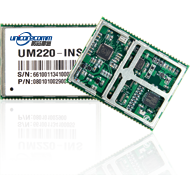
UM220-INS
BDS/GPS+MEMS dual-system inertial navigation module. Photo: UnicoreUnicore Communications, Inc., is showcasing two new products at ION GNSS+, being held September 10-12 in Tampa, Florida.
The UM220-INS is a BeiDou/GPS+MEMS dual-system inertial navigation module for in-dash automotive navigation and high-end navigation. Besides dual-system (BeiDou+GPS) GNSS navigation, the UM220-INS features a built in six-axis MEMS and can output a GNSS+MEMS inertial positioning result, making it suitable for applications requiring high accuracy, high reliability, and high continuity positioning.
The second product is the UB280, a BeiDou/GPS dual-system dual-antenna high-precision heading board for precise RTK position and heading. According to Unicore, UB280 is based on Unicore’s mature BeiDou compatible multi-system GNSS system-on-chip (SoC), features low-power design and dual-antenna input, can offer millimeter-level carrier phase observation value and centimeter-level RTK positioning accuracy, and supports multi-path mitigation. Its advanced technology of instant and long-distance RTK is designed for high-precision positioning, navigation, and heading applications in static and dynamic environments.
Features of the UM220-INS include:
- Built-in six-axis MEMS. UM220-INS has a built-in MEMS with a 3-axis gyroscope and a 3-axis accelerometer. The solution fusing GNSS and inertial MEMS enables car-navigation devices to provide a continuous and stable position under complicated environments such as basement parking and tunnels, regardless of satellite visibility.
- High-Sensitivity Design. With Unicore’s Ultra-Sense high-sensitivity design, UM220-INS can provide excellent acquisition and tracking sensitivity under weak signal conditions, maintaining the position continuity and reliability of the receiver.
- High-Integrated Design. Different from traditional GPS navigation products, built-in MEMS devices support the odometer / speed pulse, the reversing signal input, and more integrated, simplified overall unit manufacturers’ design.
- DGNSS and AGNSS Supprt. UM220-INS has extended support for differential GNSS and assisted GNSS positioning functions, and supports RTCM2.3/3.0.
- Backward Compatibility with UM220. The UM220-III N module is backward-compatible with the UM220 in size and interface, which makes upgrades easy.
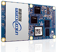
UB280 BDS/GPS dual-system dual-antenna high -precision heading board. Photo: Unicore Features of the UB280 incude:
- Design standard. This board is totally compatible with mainstream OEM boards in dimensions and electrical standards for the convenience of user’s further development. Apart from this, more hardware interfaces are available.
- Rapid RTK Integer Ambiguity Resolution. With super strong RTK algorithms, it ensures more rapid initializing speed and can make a GNSS-RTK solution on multi-constellation, thus ensuring users take the lead in the interoperability era.
- Web Interface. The UB280 supports an Ethernet interface, so users can configure the board through Ethernet, managing, upgrading, and restarting the device remotely.
- Instant Heading Technology. With an innovative RTK algorithm, Unicore has developed the real-time dynamic heading technology on variable baseline length for a moving base station. High-quality carrier observation and perfect RTK algorithm can provide a 0.2° heading accuracy on a 1-meter baseline.
- Graphical Interface. Based on the graphical Control and Display Tool (CDT), the state, SNR and elevating angle of the satellites of all the constellations could be displayed on the screen, which is convenient for application development.
Unicore Communications is located in Booth 118 in the ION GNSS+ exhibit hall.
-
Exelis GPS Threat Detection Offers Improved Capabilities
The Signal Sentry 1000. Based on customer use and feedback, Exelis has improved its Signal Sentry 1000 product to include enhanced, user-friendly analytics and alerts. Signal Sentry technology detects and locates sources of intentional and unintentional interference to GPS signals and provides users with actionable intelligence.
Exelis is showcasing Signal Sentry 1000 in Booth 619/621 at the ION GNSS+ conference September 10-12 in Tampa, Florida.
Enriched features of Signal Sentry 1000 include superior sensors that increase detection accuracy to better pinpoint the jamming source, enhanced analytics to recognize patterns of jamming, and easy-to-use history functionality to comprehend where interference happened and to follow its path. Instant reporting of jamming events via text or email so that appropriate resources may be deployed to an incident is also a new feature of Signal Sentry.
“Signal Sentry was developed by Exelis to protect critical infrastructure and to deliver intelligence to police agencies. Since Signal Sentry has been used by law enforcement, we have been able to enhance the products investigative and intelligent-led policing capabilities,” said Carl Slutsky, product line manager for Signal Sentry at Exelis. “Now, users can see patterns such as what happened and when and where it happened to better allocate their investigative resources. Additionally, we added an alert feature to Signal Sentry that provides real-time notice of a GPS jamming event, so law enforcement can dispatch a patrol unit to the precise location of the jamming event.”
Because of the broad availability of low-cost GPS jamming devices on the Internet, the risk associated with signal disruption has increased significantly. GPS jammers are often used by criminals to conceal stolen cars and by commercial drivers whose intent is merely to hide their location from their employer. Truckers who used personal-privacy GPS jammers near shipping ports have caused interference with the signal also used to navigate large ships, which severely compromised safety and the efficient operation of the port.
Signal Sentry leverages GNSS signal domain knowledge and is based upon patented technology developed through the company’s history of designing and fielding electronic intelligence systems. Exelis navigation payloads and components have been on board every U.S. GPS satellite ever launched and have more than 700 years of accumulated on-orbit success.
-
ION GNSS+ Blog: Ignite Presentations Spark Interest
Art Kalinski Blogs from ION GNSS+ in Tampa
I’m attending ION GNSS+ 2014 in Tampa, Florida, this week. Although this is a GPS conference, there are topics that will be of interest to us geospatial people. The opening plenary session Tuesday night included a series of short “Ignite” presentations that were moderated by Alan Cameron of GPS World.
I am completely sold on the concept of short “ignite” presentations, which are a preview of full sessions to come later in the conference. It was quick, kept my interest, and drew my attention to sessions that I may not have attended.
All conferences should start with this kind of quick preview of things to come.
-
Galileo Provides Update on FOC Anomaly, GLONASS a No Show
Experts representing the Galileo Program provided a frank and open update on how it is addressing the problem of the first two full operational capability (FOC) satellites being delivered to the wrong orbit. The presentation was part of the panel discussion “Status of GPS, GLONASS, Galileo, BeiDou, and QZSS” at ION GNSS+ Wednesday morning.
No one from Rocosmos attended to present information on the status of GLONASS. A Russian spokesperson had hoped to come but could not obtain a visa, for unknown reasons. There appear to be no Russians at the conference apart from one CEO of a Russian receiver manufacturing firm.
A new article in Nature magazine provides additional background on the Galileo FOC anomaly. Also, the CANSPACE listserv has been engaged in discussing the issue.
- An inquiry board is looking into problem to find the root cause of the anomaly. The board has already met several times.
- An intermediate report is due shortly; a final report and recommendations will come next month.
- The European Space Agency (ESA) is considering what can be done with the two satellites; ESA hopes to be able to use them operationally as much as possible.
- ESA is also looking at the impact on the commercial Galileo service and the search-and-rescue service.
- ESA is already narrowing down the possible causes of the anomaly.
- ESA is waiting for the enquiry board to report before deciding on when and how the next two satellites will be launched.
- The payloads of the errant satellites are currently off.
- ESA wants to try to raise the perigees of the satellites to get them out of the van Allan radiation belt as soon as possible to prevent damage to the satellites. Raising the perigrees will also to reduce the maximum Doppler frequency shift from 9.6 kHz to at least 6.8 kHz to allow receivers to easily acquire and track the satellites, but leave enough hydrazine for future station keeping.
- ESA is looking at the almanac problem and whether unused bits in the Galileo navigation message might be able to support a special almanac for the satellites.
- ESA is also looking at possible rephasing of the satellites to optimize their use with the other satellites in the constellation.
-
Loctronix Advances GNSS Integrity Monitoring with HGX Interference Detection System
Loctronix Corporation, a provider of positioning, navigation, and timing (PNT) solutions for GNSS-challenged environments, has unveiled the HGX Interference Detection System (IDS) for identifying and monitoring intentional and unintentional interference sources. The IDS is being demonstrated September 10-11 at ION GNSS+ 2014, in Tampa, Florida.
“The IDS can detect sources of interference ranging between 5 dB and 60 dB GNSS jamming to signal (J/S) ratio. Featuring a novel profiling function, the IDS not only detects, but can identify the type of interference given a database of known/previously recorded profiles,” stated Michael Mathews, Loctronix’ CEO and founder.
According to Mathews, “The greater dependence of GNSS within critical infrastructure — including, transportation, communications, finance and the growing availability of jammers — requires new tools to respond to potential threats. The IDS is the first tool to combine the powerful capabilities of Loctronix Spectral Compression Positioning (SCP) technology for identification and characterization of signals with traditional GNSS signal processing to provide full situational awareness of GPS/GNSS operations. The IDS system will benefit government, military, and commercial/industrial applications wherever there is a critical dependence upon quality GNSS data.”
The IDS was developed using the Loctronix HGX hybrid sensor toolkit along with the company’s ASR-2300 ASR Workbench software defined radio platform. The standard implementation supports L1 GNSS bands and measurement rates of 10 measurements per second. Partner-licensed custom/solutions can support multiple bands (such as L2, L5) with greater bandwidths and measurement rates. Multiple sensitivity modes enable monitoring of sub-thermal and high-power interference.
The HGX toolkit API will be available for specialization of the system for custom/embedded applications and adaptation to other hardware platforms. Visit Loctronix in Booth 422.
-

Live from ION GNSS+ 2014
Photo: GPS World The GPS World staff reports live from ION GNSS+ in Tampa, Florida, September 9-12, providing news, photos, videos and more. Check back throughout the week for updated information from the event.
BLOGS
Galileo Provides Update on FOC Anomaly, GLONASS a No Show (9/10/14)
By Richard LangleyAir Force Shares GPS Status at CGSIC at ION GNSS+ (9/10/14)
By Richard LangleyION GNSS+ Blog: Ignite Presentations Spark Interest (9/10/14)
By Art KalinksiNEWS
IWG Report: China to Join Effort on Aircraft Satnav Standards (9/23/14)
KVH Introduces Fiber-Optic Gyro IMUs for Demanding Applications (9/19/14)
IFEN Showcases SX3 Software Receiver at ION GNSS+ (9/11/14)
Topcon and MAVinci Announce Sirius Pro for Use with RTK Base Stations or NTRIP (9/11/14)
Unicore Announces BeiDou/GPS+MEMS GNSS Module, High-Precision Heading Board at ION GNSS+ (9/11/14)
Exelis GPS Threat Detection Offers Improved Capabilities (9/11/14)
Enge, van Diggelen to Teach Massively Open Online Course on GPS (9/11/14)
New Broadcom Chip Provides Always-On Location and Sensing for Mobile Applications (9/10/14)
NovAtel’s Velocity Magazine Features PPP (9/10/14)
Septentrio, Altus Showcase High-Performance RTK at ION GNSS+ (9/10/14)
Loctronix Advances GNSS Integrity Monitoring with HGX Interference Detection System (9/10/14)
Apply Orbital Science and Win at GPS World’s ION GNSS+ Booth (9/5/14)
Lockheed Martin-Built GPS Satellites Reach 200 Years of Operational Life (9/4/14)
Rohde & Schwarz Demos Latest Simulator at ION GNSS+ (9/3/14)
Sensonor Showcases STIM300 IMU at ION GNSS+ (9/4/14)
ION GNSS+ Features Natural Navigation, Commercial Track (9/3/14)
New at ION GNSS+: Live Indoor Demonstrations (9/3/14)
Dual-Frequency Pinwheel Antenna Designed for Optimal Positioning (9/3/2014)
PHOTOS

GPS World is at ION GNSS+ September 8-12, 2014, at the Tampa Convention Center in Tampa, Florida. Photo: GPS World 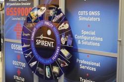
Spirent is exhibiting at the ION GNSS+ 2014. Photo: GPS World 
Exhibitors and attendees learn about one of NovAtel’s products. Photo: GPS World 
Attendees take a lunch break in the lounge at the Tampa Convention Center. Photo: GPS World 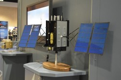
Lockheed Martin is developing the next-generation GPS III satellites (A 1/10 scale is pictured above). Photo: GPS World 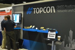
Topcon staff gather to set up their booth before attendees arrive. Photo: GPS World 
Attendees learn about StellaNGC by M3 Systems. Photo: GPS World 
Antcom antennas featured at the ION GNSS+ 2014. Photo: GPS World 
Hannu Laine of Nokia displays one of two tagged remote-controlled cars used in a demonstration of HAIP (High-Accuracy Indoor Positioning), one of seven demonstrations at the Indoor Location and Demonstration panel Wednesday afternoon. Photo: GPS World VIDEOS
Boeing
Larry Davidoff, director of advanced navigation systems at The Boeing Company, highlights the company’s Position, Navigation and Timing (PNT) system solutions at ION GNSS+ September 9-12 in Tampa, Florida. Jeffrey Goldstein shares digital navigation technology, which includes a GPS-enabled Jeppesen aeronautical aviation chart.
Antcom
Robert Dumont, international sales manager at Antcom Corporation, discusses the rugged GNSS and communication antennas as well as the microwave accessories Antcom manufactures while at the 2014 ION GNSS+ Conference September 9-12 in Tampa, Florida.
Loctronix
Michael B. Mathews, Ph.D., CEO and founder of Loctronix, details the company’s Interference Detection System (IDS) at the ION GNSS+ September 9-12 at the Tampa Convention Center in Tampa, Florida.
KVH Industries
Jay Napoli, vice president of FOG/OEM sales for KVH Industries, Inc., chats with GPS World about fiber-optic gyros (FOGs) while at the ION GNSS+ Conference September 9-12 at the Tampa Bay Convention Center in Tampa, Florida.
NavtechGPS
Carolyn P. McDonald, president and CEO of NavtechGPS, catches up with GPS World at the ION GNSS+ Conference September 9-12, 2014, at the Tampa Convention Center in Tampa, Florida. Franck Boynton, vice president and CTO of NavtechGPS, also shares about simulators with software, the company’s OEM presence and more.
Introduction to ION GNSS+
GPS World Editor and Publisher Alan Cameron discusses the importance of the annual ION GNSS Conference, held this year in Tampa, Florida.