Tag: Iridium NEXT

  • Low-cost antennas power high-precision space-based positioning

    Low-cost antennas power high-precision space-based positioning

    A novel method using signals of opportunity from low-Earth orbit (LEO) satellites is redefining what’s possible in satellite-based navigation. Researchers have developed a joint pseudo-range and Doppler positioning technique that taps into signals from constellations like Starlink and Iridium NEXT — without relying on traditional navigation signal structures.

    By employing low-cost, wide-beam antennas and a specially designed time–frequency inversion algorithm, the team achieved remarkable accuracy: 3.6 meters in 2D and 6.2 meters in 3D, surpassing Starlink positioning approaches based on parabolic antennas by 35%.

    Technical barriers in using signals of opportunity include signal transmission times, low signal power, and imprecise orbital data, all of which hinder accurate positioning. Addressing these challenges demands a new approach to extracting usable navigation data from LEO constellations.

    In response, researchers from the Aerospace Information Research Institute introduced a joint pseudo-range and Doppler positioning method using wide-beam antennas to receive LEO satellite SOPs. The approach centers on a signal time–frequency inversion algorithm that reconstructs key signal parameters, alongside a novel accuracy metric called Equivalent Position Dilution of Precision (EPDOP).

    Real-world experiments combining Starlink Doppler data and Iridium NEXT pseudo-range signals confirmed strong performance, especially in long-baseline conditions — reinforcing the method’s global applicability.

    To overcome the cost and complexity of existing satellite tracking equipment, the team employed low-noise bock (LNB) wide-beam antennas capable of simultaneously receiving signals from multiple Starlink satellites. The core innovation lies in a signal processing algorithm that estimates transmission time and frequency from the received code phase and Doppler shifts — enabling both pseudo-range and Doppler observations without needing exact satellite clock data or real-time ephemeris.

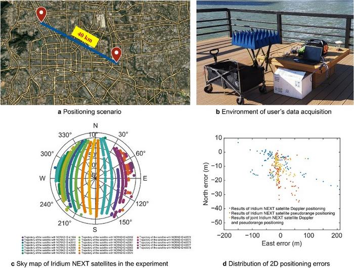
    To quantify system performance under real-world errors, the researchers developed the EPDOP metric, adapted to mixed measurement inputs. Tests demonstrated the method’s robustness: 3.6 m 2D and 6.2 m 3D positioning using Starlink Doppler signals, and up to 24 m (2D) and 41 m (3D) accuracy using Iridium NEXT SOPs over a 40 km baseline. Compared to Doppler positioning techniques, the algorithm reduced positioning errors by over one-third and successfully suppressed the impact of orbital inaccuracies inherent in public two-line element set (TLE) datasets.

    “This work marks a key step toward accessible, accurate navigation using commercial satellite constellations,” said lead author Ying Xu. “By integrating Doppler and pseudo-range measurements and introducing a flexible precision metric, we can now harness Starlink and Iridium NEXT signals for high-precision positioning, even without access to proprietary signal structures. The proposed low-cost architecture opens new possibilities for resilient navigation in GPS-denied environments.”

    Because of its ability to operate with low-cost antennas and weak, unstructured signals, the technique is poised to support a wide range of applications: from autonomous driving and unmanned aerial vehicle (UAV) navigation in remote regions to emergency response and IoT asset tracking. Its resilience to satellite orbital prediction errors and adaptability across different LEO constellations make it a strong contender for next-generation positioning systems. As LEO deployments continue to expand globally, this approach offers a scalable and practical solution for real-time, high-accuracy navigation—promising enhanced capabilities for both civilian infrastructure and defense operations.

    The researchers’ study is published in Satellite Navigation (DOI: 10.1186/s43020-025-00163-y).

    Signal acquisition of Iridium NEXT satellites’ signal in the long baseline positioning scenario. (Credit: Aerospace Information Research Institute)

  • Second set of Iridium NEXT satellites in orbit

    Second set of Iridium NEXT satellites in orbit

    The second set of 10 Iridium NEXT satellites, launched June 25 by SpaceX, are functioning nominally and have begun the testing and validation process.

    The batch of 10 satellites was launched from Vandenberg Air Force Base in California, increasing the total number of Iridium NEXT satellites in space to 20.

    “We are thrilled with yesterday’s success,” said Scott Smith, chief operating officer at Iridium. “These new satellites are functioning well, and we are pressing forward with the testing process.”

    “Since the last launch, the team at our Satellite Network Operations Center has been anxiously awaiting this new batch of satellites. There is a lot of work to do, and we are up for the challenge,” he said.

    Now, and for approximately the next 45 days, the newly launched satellites will undergo a series of testing and validation procedures, ensuring they are ready for integration with the operational constellation.

    Once testing is completed, Iridium will also hand over control of Aireon’s Automatic Dependent Surveillance-Broadcast hosted payload, to the team at Aireon’s Hosted Payload Operations Center, in Leesburg, Virginia.

  • SpaceX launches first batch of Iridium NEXT satellites

    Iridium Communications Inc. has successfully launched its first 10 Iridium NEXT satellites, which will support real-time automatic dependent surveillance broadcast (ADS-B) operations in oceanic regions.

    Iridium NEXT is the company’s next-generation satellite constellation, replacing and enhancing its existing network of low-Earth orbit satellites spanning the entire globe — the largest commercial satellite constellation in space.

    A SpaceX Falcon 9 rocket lifts off from Space Launch Complex 4E at Vandenberg Air Force Base, California, Jan. 14. (Photo: SpaceX)
    A SpaceX Falcon 9 rocket lifts off from Space Launch Complex 4E at Vandenberg Air Force Base, California, Jan. 14. (Photo: SpaceX)

    The satellites were delivered into low-Earth orbit an hour after a SpaceX Falcon 9 rocket lifted off from Vandenberg Air Force Base in California at 9:54:39 a.m. PST on Jan. 14.

    The launch is the start of a series of Iridium NEXT launches scheduled over the next 18 months, and marks the beginning of one of the biggest “tech refreshes” in history, completely replacing the only satellite constellation providing 100-percent global communications coverage.

    Once fully deployed, Iridium NEXT will enable a new broadband multi-service capability called Iridium CertusSM, while providing the technical flexibility to support innovative new services and technologies from Iridium’s extensive partner network.

    Aircraft surveillance

    Among those technologies is a unique hosted payload from Iridium’s partner Aireon, which will provide a real-time global aircraft surveillance service, extending aircraft visibility across the planet.

    Aerion’s space-based ADS-B receiver network will relay signals from all ADS-B equipped aircraft to controllers worldwide, allowing 100 pecent global air traffic surveillance. (Image: Aerion)
    Aireon’s space-based ADS-B receiver network will relay signals from all ADS-B equipped aircraft to controllers worldwide, allowing 100 pecent global air traffic surveillance. (Image: Aireon)

    According to Aireon, its space-based ADS-B network will transform air traffic management capabilities, providing air traffic surveillance and flight tracking across 100 percent of the planet. Currently, more than 70 percent of the earth, including oceanic and remote airspace, has no existing air traffic surveillance.

    The first 10 Iridium NEXT satellites were delivered to a 625 kilometer (km) temporary parking orbit where they will be tested and exercised by Iridium over the coming weeks. Upon meeting testing and validation requirements, the satellites will then be moved into their 780-km operational orbit and begin providing service to Iridium’s customers.

    As part of this testing and validation process, Aireon’s ADS-B receivers, which were manufactured by Harris Corporation, will provide air traffic surveillance data through the Aireon network to the Service Delivery Points (SDPs) at partners NAV CANADA, NATS, ENAV, the Irish Aviation Authority (IAA), as well as the Federal Aviation Administration (FAA) William J. Hughes Technical Center in Atlantic City, New Jersey.

    One by one, the new satellites will be positioned near a current generation satellite, each moving at approximately 17,000 miles per hour as testing begins. Iridium’s inter-satellite communication links from nearby satellites will be repositioned to point to the new Iridium NEXT satellite as it prepares to take over service. Existing satellites will eventually be de-boosted and de-orbited.

    “Today Iridium launches a new era in the history of our company and a new era in space as we start to deliver the next-generation of satellite communications,” said Matt Desch, chief executive officer of Iridium. “We have been working endless hours for the last eight years to get to this day, and to finally be here with ten Iridium NEXT satellites successfully launched into low-Earth orbit is a fulfilling moment. We are incredibly thankful for all of the hard work from our team, as well as our partners, to help us achieve this milestone.”

    Both Thales Alenia Space, System Prime Contractor for the program, and their subcontractor for production, Orbital ATK, have been integral in the development of the Iridium NEXT program, from the design and manufacturing of the Iridium NEXT satellite vehicles to managing an 18-station, state-of-the-art assembly line production system.

    “Leading a worldwide team to manufacture, assemble, test and prepare each satellite for this moment has been incredibly exciting,” said Bertrand Maureau, executive vice president of telecommunications at Thales Alenia Space. “We are very proud to have conducted such a unique program, in terms of scale and complexity as well as to have successfully completed the end-to-end whole constellation on-ground validation. The system is fully tested, and the compatibility of Iridium NEXT with the Block-1 operating satellites has been perfectly demonstrated. It has truly been an honor, and we are looking forward to completing the rest of the Iridium NEXT constellation through 2017 and early 2018.”

    “We are proud to be a part of this revolutionary satellite program,” said Frank Culbertson, president of Orbital ATK’s Space Systems Group. “Seeing these first ten satellites launch successfully into space is the result of a unique assembly-line process at our satellite manufacturing facility that represents a remarkable achievement. We look forward to seeing the innovative solutions these satellites, which are great examples of leading-edge technology and manufacturability, will enable.”

    In addition to partnering with Thales Alenia Space as System Prime Contractor, Iridium has partnered with SpaceX for the launch of 70 Iridium NEXT satellites on its Falcon 9 rocket.

    “We are very proud to be chosen as the launch provider for the entire Iridium NEXT program and are excited about today’s successful first launch,” said Gwynne Shotwell, President of SpaceX. “Iridium was one of SpaceX’s first customers, and working alongside them to deliver one of the largest aerospace projects underway is an exciting moment for us at SpaceX.”

    Iridium and SpaceX are partnered for a series of seven launches, deploying ten Iridium NEXT satellites at a time. The next major milestone will be the completion of on-orbit testing of these satellites, to validate performance requirements are met.

    The second Iridium NEXT launch will be scheduled after testing is completed in April. The entire Iridium NEXT network is scheduled to be completed by mid-2018.

  • Iridium launches alternative GPS PNT service

    Iridium Communications Inc. has introduced its Satellite Time and Location (STL) service, an alternative or complement to traditional indoor and outdoor location-based technologies, and declared it ready for use. STL’s position, navigation and timing (PNT) technology is deployed through Iridium’s 66 cross-linked, low-earth orbit satellite constellation.

    Through Iridium satellites and in GNSS receivers, STL technology can work to verify GPS, GLONASS, Galileo and other navigation services, and also can serve as an alternative for those services when GPS signals are degraded or unavailable. STL also can provide an alternative source of time when testing GPS signals.

    Iridium is working with Satelles, a division of iKare Corporation, as its primary technology partner. Satelles enables Iridium’s paging channels to reach small, low-cost receivers in nearly any environment, the company says in a news release.

    “We think STL can help solve an important and growing problem for governments and businesses, and serve as a platform for continued innovation,” says Matt Desch, chief executive officer at Iridium. “With STL, we are introducing a global capability that is already in space, technologically ready for use and is independent of any particular location technology. The team at Satelles has been able to leverage the unique capabilities that our network offers to create a solution that can ultimately be integrated into almost any kind of platform, including other Iridium machine-to-machine devices, heavy machinery, automobiles and even the power grid, to name a few. Once implemented, STL could revolutionize the way the world’s largest, global companies and governments operate and manage cyber security.”

    In a chipset about the size of a postage stamp, the technology can be embedded into many devices. STL’s signal strength may make spoofing GPS systems more difficult, the company says. STL transmits its signals through Iridium’s satellite constellation to deliver a unique code to each position on the ground that can be independently authenticated, which allows operation or access only if the user is in the location expected.

    “Commercial users are now able to use STL to deliver trustworthy timing solutions for critical infrastructure, such as LTE networks, transactional data centers and the power grid,” says Greg Gutt, president and chief technology officer of Satelles. “Military and government users can also acquire these commercial off-the-shelf solutions for the Department of Defense and other government applications. In addition to enhancing the security and resiliency of GPS, STL technology can be embedded into servers anywhere in the world to geo-fence data and applications, providing trusted time and location data as an independent factor for end-point authentication.”

    The STL solution has been successfully demonstrated across multiple sectors, including military, academia and commercial applications. The technology is available today and will be supported by Iridium NEXT, the Iridium’s next-generation global satellite constellation, which is scheduled for completion by late 2017, the company says.

  • Harris, exactEarth Form Alliance for Global Maritime Tracking

    exactEarth Ltd. and Harris Corporation have formed an alliance to provide a new level of Satellite Automatic Identification System (AIS) data service that will deliver real-time global coverage for maritime vessel tracking. The new service will leverage the persistent global coverage and real-time connectivity of the Iridium NEXT constellation through the implementation of 58 hosted payloads covering the Maritime VHF frequency band.

    Harris is a space, geospatial and remote sensing company, and exactEarth is a provider of AIS data services.

    Compatibility testing of the hosted payload with the Iridium satellites has been completed. The first launch is scheduled for early 2016, with the completed constellation expected in 2017. The new service will provide customers with the fastest, most accurate vessel information available. With revisit times and latency under one minute, the service expansion represents a leap forward in the ability for both Harris and exactEarth to offer global ship tracking and maritime information solutions, the companies said in a statement.

    The alliance leverages exactEarth’s proven and patented signal de-collision detection technology and Harris’ expertise in satellite hosted payloads, advanced radio frequency technology and antenna solutions. Harris becomes the exclusive provider to the US government of AIS products and services produced under the alliance, including exactEarth’s exactAIS product portfolio, while exactEarth continues to serve all other global markets.

    “This alliance will expand our IntelliEarth family of innovative solutions, which leverage Harris’ world-class remote sensing capabilities to help customers around the globe make smarter operational and business decisions,” said Bill Gattle, vice president and general manager, National Programs, Harris Government Communications Systems. “Harris is committed to exploring new technologies and partnering with world-leading organizations to provide our customers with the greatest value.” 

    “As the recognized Satellite AIS industry leader, this announcement further strengthens our commitment to provide best-in-class maritime intelligence solutions to our customers worldwide,” said Peter Mabson, Ppresident of exactEarth.  “We are thrilled to be able to offer the shortest revisit times and lowest latency for developing true maritime domain awareness. This partnership with Harris will allow us to significantly expand the range of advanced value-added services and information solutions that we can bring to the global maritime market.”

  • Aireon Plans Global Emergency Tracking Service for Aircraft

    Aireon LLC, developer of a space-based ADS-B global air traffic surveillance system, is planning the Aireon Aircraft Locating and Emergency Response Tracking (Aireon ALERT) service, a global emergency tracking service that will be provided free of charge to the aviation community beginning in 2017. The Aireon ALERT service will allow rescue agencies to request the location and last flight track of any 1090-MHz ADS-B equipped aircraft flying in airspace currently without surveillance.

    “A comprehensive, global aircraft tracking solution is essential in emergency situations, as evidenced by MH370 earlier this year and Air France 447 in 2009,” said Don Thoma, president and CEO, Aireon. “Aireon is being deployed to improve the efficiency and safety of aircraft operations in oceanic and unsurveilled airspace. The same technology behind these efficiency and safety gains can also make a significant difference in providing quick, accurate information in emergency situations. With one global view of ADS-B equipped aircraft, Aireon ALERT will provide accurate and real-time tracking data immediately to authorized search-and-rescue operations, without requiring airlines to equip aircraft with new avionics or the ANSPs and authorities to deploy new systems.”

    Aireon is deploying a global space-based ADS-B surveillance capability providing direct air traffic controller visibility of flights operating in oceanic or remote airspace, focused on improving the efficiency and safety of aircraft operations. When Aireon is fully operational, anticipated for 2017, it will create a powerful platform capable of tracking ADS-B equipped aircraft around the globe in real time.

    The Aireon ALERT service will be available soon after Aireon’s full deployment and will be provided through a 24/7 application and emergency call center. Historical track data will be available to pre-authorized users, including ANSPs, airlines, and search-and-rescue authorities, through Aireon ALERT soon after controller communications are lost with an aircraft. The system can also provide real-time tracking of aircraft in distress, provided ADS-B transmissions are still operational.

    “Tracking of aircraft in emergency and search-and-rescue situations is a complex issue,” said Cyriel Kronenburg, vice president sales and marketing for Aireon. “We plan to engage the various aviation stakeholders including the airlines, ANSPs, regulators, and search-and-rescue organizations over the next 12 months to define the technical, operational, and legal details of providing this data in emergency situations.”

    “We anticipate support from the world’s airlines for the approach taken by Aireon for emergency tracking,” said John Crichton, president and CEO of NAV CANADA. “Airlines already stand to gain over $125 million per year in fuel savings in the North Atlantic alone by using Aireon’s space-based surveillance service. The Aireon ALERT public service offers an additional benefit, free of charge, ensuring that ADS-B equipped aircraft can be tracked anywhere in the world, even in airspace managed by ANSPs that have not subscribed to the Aireon service.”

    Aireon is a joint venture among Iridium Communications Inc., NAV CANADA, ENAV, IAA, and Naviair, established to launch the Aireon system by hosting ADS-B receiver payloads on Iridium NEXT, Iridium’s second-generation satellite constellation, scheduled for first launch in 2015. This new capability will extend air traffic surveillance to the entire planet and increase the safety and efficiency of air travel over oceanic and remote regions.