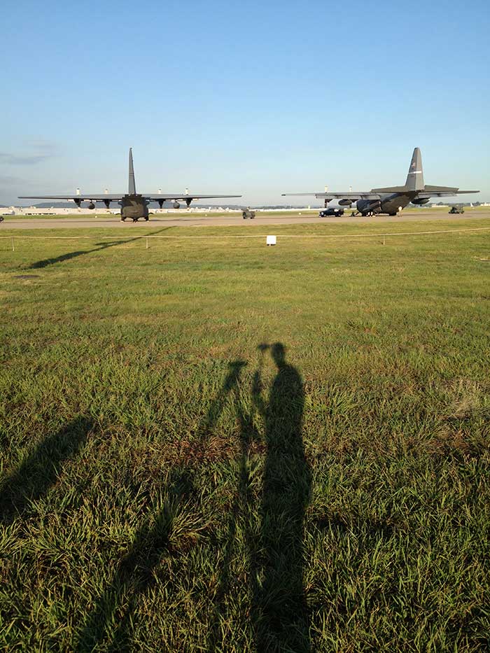
Helping the guard: For the Kentucky Air National Guard, Sibole surveyed for paint lines on the taxiway for C-130 aircraft. (Photo: Matt Sibole)
Like Adam Plumley, Matt Sibole is also a solo surveyor and a Javad GNSS advocate. Based in Kentucky, Sibole tackles up to 140 jobs a year, which he would be unable to do using only a total station or a robotic station. Instead, he relies on the accuracy of GNSS.
He particularly relies on J-Field, the Javad GNSS data-collection software. When using the software’s “Boundary Profile” feature, he can get a fix, then re-initialize and get another fix that he can then compare in real time to the previous fix.
“J-Field keeps all fixes in memory to compare to each other, until you get a group of fixes that agree with each other to verify which fix is the correct fix,” Sibole explained. “We all know that a fix is not necessarily the ‘right’ fix. Javad’s J-Field program will give the user the confidence to know in real time that the shot is correct.”
“J-Field also has a relative accuracy calculator built in to verify that I meet minimum standards in the field before I leave the site,” Sibole said.
Javad GNSS, makers of the Triumph-LS Rover receiver and the Triumph-1 and -2 base units, is offering a software procedure called Cluster Averaging, which takes advantage of its six different RTK engines and the J-Field receiver firmware.
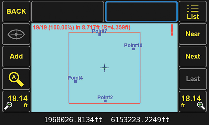
While a typical survey point collected by RTK methods requires multiple occupations to verify the integrity of the location and elevation, Javad GNSS’ J-Field program significantly reduces survey by collecting multiple sets of survey data through each RTK engine, the company said. During the data acquisition process, the receiver automatically forces a loss of satellite lock and restart to ensure multiple sets of independent data are collected for redundancy and quality assurance.
Four groups of surveyed points. (Image: Javad GNSS)
As the surveyor returns for another set of redundant data, Cluster Averaging will recognize the previous surveyed points to provide error analysis using their chosen parameters for quality assurance. The surveyor may allow the J-Field software to average all of the data points or pick and choose those needing specific verifications. Also, the surveyor can specific different precisions for varying types of data collection (for example, control points vs. topographic data).
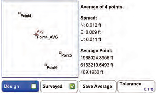
(Image: Javad GNSS)
Point numbering and data attributes are also automated during the cluster averaging processes. Once the operator has designated both number and field code, this information is reused each time to eliminate potential conflicts.
Reports from the J-Field program documenting the locations with multiple occupations are easy to generate and informative, Javad GNSS said. By reviewing the results of the clusters, data integrity can be decided at the time of the survey and save time by later office verification. The surveyor can confidently complete the survey task knowing proof of accurate data for the project is at his/her fingertips.
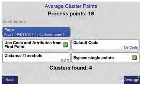
(Image: Javad GNSS)
Cluster averaging within the J-Field program simplifies the redundant task of point verification, with a user-friendly interface and report, the company added.