A little more than a year ago, I became a part of a team of surveyors from across the country to offer testing and input on new technology and programing coming out of JAVAD GNSS. It has been a great honor to work along with Dr. Javad Ashjaee, the other surveyors and Javad’s staff at JAVAD GNSS. Why Javad chose me, I doubt that I will ever know. While I am proud to be a part of what Javad has dubbed “J-Team,” I have realized very quickly how little I know about GNSS. In this series of articles that I plan on putting together, I will chronicle my advances in GNSS and testing of JAVAD GNSS equipment.
As part of my testing, I have been using a JAVAD Triumph 2 base (with 4-watt external radio) and a TRIUMPH-LS rover. I had seen advertisements for this system for many months prior to becoming a member of the J-team. I was apprehensive at first with the difference in the appearance and learning the new software. However, it did not take long to realize how advanced this system, namely the TRIUMPH-LS, was.
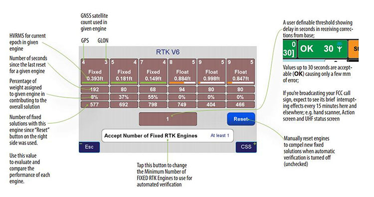
One key feature that I use to determine the quality of my shots is the V6 engines. The V6 engines that it uses to fix the ambiguities is unlike anything I have seen in any other software or receiver. The V6 engines are six separate RTK engines running simultaneously. Basically, this is like having six separate receivers in one.
When in heavy multipath area, I tend to stay fixated on this screen. Each engine can fix at different times. When another engine gets fixed, the resulting epochs are averaged between the two fixed engines and so on with any of the other engines. (See above image.)
This is only one of many technological advancements that Javad has included in his newest receivers. Please continue to follow my articles on other advancements and general surveying practice topics.
For more information on Javad’s J-Field software, the TRIUMPH-LS or other JAVAD GNSS solutions, please feel free to visit www.javad.com, email [email protected], or call 1-888-550-5301 or 1-408-770-1770.
Matthew D. Sibole is a Professional Land Surveyor (PLS) and a member of the JAVAD GNSS J-Team.
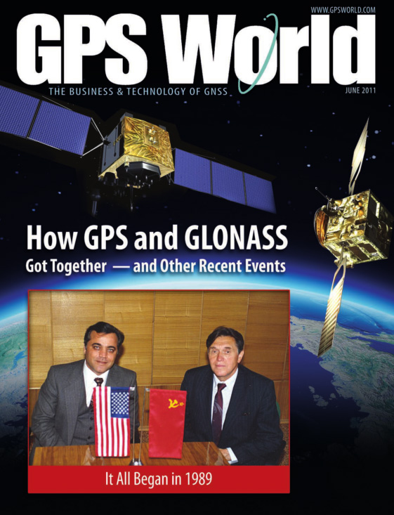
25 years ago, while the Soviet Union still existed, I began efforts that led me to become the first to combine United States’ GPS and Russia’s GLONASS satellites. Later I hosted many GPS and GLONASS authorities, fostered friendships among them, and promoted concepts such as “compatibility” and “interoperability” of satellite systems. See the details in the GPS World article, “How GPS and GLONASS Got Together.” The whole world now benefits from the combined GPS and GLONASS system.
As with GPS and GLONASS, we need to get together again. Just because I am passionate about technical issues does not mean that I ignore human issues. This time it is not about technology. This time it is about We the People.
For citizens of the United States, founded on this concept, it is inconceivable that we might one day wake up and learn that one of our States had been “gifted” to a neighboring country. But this is exactly what happened to the people of Crimea. Since 1784, Crimea was part of Russia and its people lived peacefully and happily as part of Russian culture and heritage. In 1954, approximately 75 % of the Crimea population were ethnic Russians. One day they woke up and learned that Nikita Khrushchev, the successor to Stalin, had “gifted” their land to Ukraine (reportedly for his own political gain).
Anyone familiar with the history of the Soviet Union knows that the people of Crimea were not able to raise objections. They were ruled under the dictatorship of Khrushchev who is known in the West for pounding his shoes on the table in the United Nations and threatening the United States. Those who claim Crimea does not belong as part of Russia give credence to the action of Khrushchev.
Should people have a ‘say’ or ‘voice’ in their future? Contrast the actions of Khrushchev in 1954 with that of Scotland and Quebec in more recent years. Crimeans had no choice about their fate, it was decided by the unilateral action of one man. Whereas, when some people in Scotland and Quebec wanted to secede, all people were allowed to vote to determine their fate.
After the collapse of the Soviet Union and the establishment of better relations between Russia and the Western world, East and West Germany rightfully reunified after an imposed ‘wrong’ of separation, but at no time did anyone come to the aid of the Crimean people to correct their ‘wrong’. Even worse, when the current issue surfaced, the US and Europe stood opposed to them.
It is not only my personal observation that Crimeans love their motherland of Russia. Forbes magazine contributor, Kenneth Rapoza, in his March 20, 2015 article writes that: “[…] poll after poll shows that the locals […] are all in agreement: life with Russia is better than life with Ukraine.”
The position of the West regarding Crimea has exacerbated the problem of Ukraine, and despite financial hardship in Russia, Putin’s popularity has skyrocketed while the United States’ standing has plummeted among the Russian people.
One can argue that President Putin and Russia could have used a better approach to help the people of Crimea achieve their goals and aspirations, but many believe that the West did not leave him a better choice. I don’t agree with many of President Putin decisions, but on this issue Vladimir Vladimirovich is exactly right.
I once worked to bring together GPS and GLONASS; I wish I had the opportunity to invite Presidents Obama and Putin to my California or my Moscow facilities to see if we could put an end to this situation.
Dr. Javad Ashjaee
JAVAD GNSS
March 21, 2015, San Jose, California
For the story of how Ashjaee “hosted many GPS and GLONASS authorities, fostered friendships among them, and promoted concepts such as compatibility and interoperability of satellite systems,” see the cover story of GPS World’s June 2011 issue, “How GPS and GLONASS Got Together.”
In the June issue’s cover story, “Interchangeability Accomplished,” is a paragraph headed, “Satellite Intersystem Biases,” which appears to assert that Galileo System Time (GST) is 3 seconds ahead of UTC.
However, in the version of the Galileo Signal In Space Interface Control Document posted at: http://ec.europa.eu/enterprise/policies/satnav/galileo/files/galileo-os-sis-icd-issue1-revision1_en.pdf, paragraph 5.1.2 appears to indicate that Galileo System Time (GST) was synchronized, at the second level, with GPS time on 22 August 1999 (that is, 13 seconds ahead of UTC). And, given that a) GST, like GPS time, does not step for announced leap seconds, and b) the IERS has, as of today, announced 3 leap seconds since 22 August 1999, such would appear to suggest that GST is presently roughly 16 seconds (vice 3 seconds) ahead of UTC.
— Stuart Eventhal Fountain, Colorado
Author Frank van Diggelen replies:
Yes! You are right, the article should have said 16 seconds for Galileo, not 3. Thanks for catching that. I’ve corrected the text that appears in the online version of the article, and the accompanying figure.
Media Scoop
The online article covering Javad Ashjaee’s input on the GLONASS situation makes a positive statement that clarifies what has been a horrible reporting job across the board by news channels.
Fox, CBS, NBC, and ABC should all be ashamed that GPS World scooped them on what appears to be a simple story.
Good work.
— Mark Silver IGage Mapping Corporation Salt Lake City, Utah
To Consumer-Grade GNSS Chip Manufacturers
I would like you to consider including a very simple feature in your GPS functionality that will permit elevation to be identified to decimeter level in many instances. The changes needed to the chip are simply the ability to accept an accurate latitude and longitude input, and an elevation calculation function that uses input latitude and longitude.
In addition to enabling instantaneous calculation of an accurate elevation, it may be that a “residual better accuracy” will remain for some time after the calculation, and that this will permit substantially improved latitude and longitude identification at a close distance.
The geo-location scene has evolved rapidly over the past 20 years. It is now very commonplace to be able to locate the latitude and longitude of a location extremely quickly and extremely accurately. For instance, the Google Earth image from the front of my house shows the dotted dividing line in the center of the road. Measuring one of these lines in Google Earth gives a size of 3.1 meters by 20 to 30 cm wide. The lines actually measure 3.0 meters by 12 cm wide. From within Google Earth I can identify the latitude and longitude of the end point on the centre of this line to within ±10 cm with a high degree of confidence. In addition there may be some other small errors in Google’s reporting of the latitude & longitude (for example due to placement of the image or distortion of the image), but these are hopefully minimal.
Now if I place my GPS unit on the end center of this line in the road, I am provided with a result that I know is erroneous. The GPS horizontal location shown in Google Earth is very rarely within two meters of my known location. It is known that altitudinal accuracy is always some two times worse than horizontal accuracy.
If I can simply tell the GPS unit that I am at this known horizontal location, it is a relatively simple calculation to recalibrate the clock and pseudoranges to provide my elevation, which will have an accuracy of a two times the accuracy of the horizontal position. Decimeter horizontal accuracy will provide 2-decimeter altitude accuracy. This is close to 100 times better than the elevation accuracy currently available on any consumer grade stand-alone device and is also effectively instantaneous!
This functionality is simple to implement. I would hope that it could be implemented with nothing more than an upgraded ROM which includes a new API function to allow the input of “I know this is my current horizontal location” and an enhanced calculation process which uses this horizontal location to calculate altitude.
I am unsure whether a residual improvement in accuracy can be attained. Even an improved accuracy for 1 minute after the fix would be useful in many situations, and an improved accuracy for 5 to 10 minutes would be a boon.
“Use any opportunity to create friendship and peace,” urged Javad Ashjaee, president and CEO of JAVAD GNSS, in a May 23 conversation with journalists. He decried the recent controversy about monitoring stations on both U.S. and Russian soil, saying it was based in misinformation and misinterpretations, inflated by a political crisis in a completely different area. “This [GNSS] is a good thing, that for 25 years kept us together. And if you see, there are lots of high-level meetings between U.S. and Russian officials, they are all very friendly meetings.”
A transcription of his remarks appears here, below the following main points and clarifications that he wished to make:
• Earlier this year, Russia sought GLONASS monitoring stations in the United States, not for uploading any data, but for monitoring GLONASS satellites to provide more accurate orbit and clock information, for the free and open benefit of all users.
• The Russian general who threatened to close down monitoring stations on Russian soil that contribute data to the International GNSS Service was immediately and roundly criticized by Russian scientists and surveyors. The general subsequently retracted his remarks.
• The 11-hour GLONASS outage on April 1 was not due to a wait for all satellites to pass over ground control stations on Russian soil to receive a fresh upload of data. GLONASS has the capability (as does GPS) to make such updates via inter-satellite communication. The delay was caused by the time it took to find the bug in the erroneous software that had been uploaded, and to correct it.
• Ashjaee also noted that “No military activity requires millimeter accuracy. It is only scientific applications for humanitarian tasks that require millimeter accuracy. Needing more monitoring stations, such as the IGS stations, is only for that purpose.”
The Background
Javad Ashjaee, founder and CEO of JAVAD GNSS, contacted GPS World on May 20 with a message: “I had a discussion today with the head of the GLONASS program in RosKosmos regarding the tracking sites that they wanted to establish in the United States, and the subsequent events. What has been published in most U.S. media is far from the truth. It is time that we contribute to defusing problems rather than putting more fuel on the fire. The world has enough problems already.”
The Full Statement
This is the story of GPS/GLONASS. It also gives some insight as to how things get out of control, and much, much bigger issues like war and things like Ukraine get created. It is just a tiny, simple example.
When I first heard the issue of GLONASS about 25 years ago and was invited by RosKosmos to Moscow, I didn’t think of Communism or anything political, I thought “30 satellites free, that they’re willing to give to the world, free of charge.” That’s how I got excited. Recently, GPS World published a wonderful history of the growing development of GLONASS and GPS.
What bothers me now is some negative reactions that I see towards GLONASS. It seems that when they see something negative about GLONASS, they enjoy it. In the reports, read between the lines. When there is a problem with GLONASS, you sense some sort of happiness. There is something of “them versus us.”
There was the question, “Why do they need things in our country? Don’t they have them in their country?”
When people don’t know each other, they fear and they create fear.
One thing we should look at: GLONASS is good for all of us. As President Reagan offered GPS free of charge to the world, and everybody applauded him — the Russians have done the same thing. In Oklahoma, California, everywhere, farmers and surveyors are using GLONASS free of charge, the same as GPS. And GLONASS has been better, and I emphasize, it has been better because they didn’t encrypt their code so that we had to go behind and decipher and decrypt and all the trouble that we went to during the past 20 years, because GPS didn’t think that we need carrier phase.
GLONASS is good for America, for the world, as is GPS. If there is a problem with GLONASS, we must be unhappy, as we are unhappy when there is a problem with GPS. And if we can help GLONASS, we must help GLONASS. There is nothing to fear about war, nobody needs [millimeter-level] accuracy of GPS or GLONASS if there is a war between super-powers.
We should all want GLONASS to give precise information. We care about centimeter-level accuracy, the military doesn’t. Five-meter accuracy is good enough for them. To improve the precise-orbit information of GLONASS is the concern of surveyors and those that need precision GPS.
Now, what’s the issue? GLONASS needs 50 reference stations all around the world to monitor the orbits of its satellites, to make the precise-orbit information [furnished to users] better. Not to upload information to the satellites. For this, one station is enough, for both GPS and GLONASS, because both have inter-satellite connections that can do this.
There was speculation in early April that it took GLONASS 11 hours to correct a software bug because it took that long for all the satellites to pass over a control station on Russian soil. This was not the case, I have learned from conversations with their engineers and with the head person responsible for all of this. One engineer made a mistake and uploaded the wrong software. Until they could find it and debug it — and it took them 11 hours to do so — they could not upload correct software to the satellites.
What they are asking for from the United States is not an upload station. They need as many [globally-distributed] monitoring stations as possible; 50 is good.
The International GNSS Service (IGS) has 300. To have a good orbit determination for scientific work, to get to the depth of centimeter- or millimeter-level accuracy, the objectives of IGS reports is to have 200 or 300 monitoring stations. For military work, three or four is enough.
Russia already has more than 50 monitoring stations. They use IGS stations. They didn’t need to ask for anything. Even [data from] the units we have in our San Jose office is available to everybody.
So I asked the GLONASS people, “Why did you ask? You have [access to more than] 200 monitoring stations!”
This was the issue: it was only political. When RosKosmos made internal presentations in Russia to their [government and military] decision-makers, they were asked, “OK, these stations are controlled by who?” By the IGS, they answered. They were told “You must have stations under Russian control.”
I explained to them that IGS stations, for them, are more convenient and more secure. If President Obama told the IGS, told Stanford University and 200 other universities, to turn off their IGS stations, there would be a lot of disagreement! President Obama could turn off Russian stations on U.S. soil. I told them, IGS stations are more convenient and more secure for you than your own stations, and they understood. They are not pushing for it, they said those officials on the top, they know nothing. They were asking that we must have five stations under our control.
If you understand this: that the issue was [Russian internal] political, that they don’t need anything. They already get the precise orbit data from IGS stations.
Now, the second part or episode of this problem: when a Russian general heard that the United States said “No” to the request for Russian-controlled monitoring stations on U.S. soil, he said “Oh, now they don’t let us do this? We will turn off their stations in Russia.” All surveyors and all scientists in Russia jumped at that general, and he retracted what he had said.
But people who didn’t understand this [that IGS-participating stations in Russia have nothing to do with controlling GPS satellites or supplying GPS data to users], they put their own statements in the press, they added fuel to the fire.
The Q&A
When asked how surveyors in Oklahoma could help GLONASS, as he had urged, Ashjaee replied “They can write to their senators and ask, why didn’t you let monitoring stations be in the heart of Oklahoma too?”
Afterthought
Once the first version of this online story was posted, Javad Ashjaee sent in this further comment:
“Part of my admiration for the GLONASS team is that they managed to pull this project off amidst their worst economical, social, and political times. Compare their situation with GPS that had a huge budget (and still ran way over budget) and with Galileo that took several rich countries to put the budgets and technology together. GLONASS also offered this free and unrestricted service to the world without making any political gestures. No encryption of codes and no selective availability either.
“There is an abundance of opportunities to create hostility, and there are enough people to promote it. Situations like this are rare that we can grasp the opportunity to promote friendship.”
On Thursday, March 20, CEO Javad Ashjaee of JAVAD GNSS will conduct a free webinar on the current state-of-the art in high-precision GNSS technology: Where is high-precision GNSS today? Where is it headed?
Further topics include new products and solutions from JAVAD GNSS, U.S. sales and customer-support news, and the offer of a two-week free trial for professional land surveyors of the JAVAD GNSS’s newest equipment, the TRIUMPH-LS and TRIUMPH-2. There will also be a question and comment session with one of the industry’s most accessible CEOs. Register here.
The 75-minute free webinar starts at 1 p.m. Eastern U.S. Time, 10 a.m. Pacific.
JAVAD GNSS has launched a new version of the TRIUMPH GNSS receiver, which features 864 channels — more than any receiver it has yet offered. The TRIUMPH-LS land survey receiver offers, in addition to the 864 GNSS channels, three powerful processors, 256 I/O, 24 digital filters, 24 anti-jam filters and 14-MB program memory all in a single chip, which uses less power and makes the total system less expensive, according to the company.
The announcement was made at the ION GNSS+ Conference, being held this week in Nashville, Tennessee.
Javad Ashjaee, CEO and founder, explained the decision to incorporate 864 channels. “Some questioned the need for the 216 channels. They now realize the need for 440 channels. We assign multiple channels to each satellite for redundancy and reliability. We use more than 100 channels to scan GNSS bands for interference — 864 channels is the key to reliable performance.”
The TRIUMPH-LS provides visual stake-out, six parallel RTK engines, more than 3,000 coordinate conversions, advanced coordinate geometry features, and rich attribute tagging on a high-resolution 800 x 480 pixel display. When used in photogrammetry, offsets can be calculated using the internal camera for 10-centimeter accuracy, or an external camera for 5-centimenter accuracy. TRIUMPH-LS is the first JAVAD GNSS receiver to offer photogrammetry for land survey.
Other features include versatile attribute tagging, feature coding, automatic photo and voice documentation, and an interference monitoring and reporting feature.
The TRIUMPH-LS has a battery life of 25 hours in RTK rover mode with full screen brightness and UHF/GSM. Two hours of charge equals two days of surveying. The internal batteries are field serviceable and can be easily replaced by the user when needed.
The TRIUMPH-LS, including batteries and pole, is the lightest GNSS RTK receiver in its class, according to JAVAD GNSS. The total weight of the system — including radio, controller, pole and 25 hours of internal battery — is 2.5 kilograms.
Built on a tough magnesium alloy chassis, all connectors, SIM cards, and micro-SD cards are protected against harsh environmental conditions. The pole can be collapsed and the unit can easily fit in a car seat — there are no long poles and no separate controller or brackets to disassemble.
The TRIUMPH-LS automatically updates all firmware when connected to the Internet via Wi-Fi. The built-in GNSS full tracking antenna has a large ground place and excellent centering and rotational performance.
To learn more about the TRIUMPH-LS, stop by the JAVAD GNSS booth (Booth D) in the ION GNSS+ Exhibit Hall now through Friday.Presentation will be given Thursday at the conference room of the exhibition hall at 2:00 pm.
A Proactive Approach for More Efficient Spectrum Use
In my vision of the future of GNSS, I see a pressing need to manage radio-frequency spectrum more efficiently. This will drive the creation of official standards for GNSS receivers, and better design of those receivers with better filters at lower cost, to protect against out-of-band and near-band interference. This in turn will enable user to undertake widespread monitoring and reporting of in-band interference, and create the freedom for many technologies to explore wider and more productive use of all bands of the radio-frequency spectrum.
Spectrum Management
As a consequence of unprecedented technological development on all fronts and in many fields, the radio-frequency spectrum is very congested. All countries, and the United States in particular, must find ways to use this spectrum more efficiently. Licenses for spectrum bands are very expensive, and special interest groups do all they can to secure ownership of any part of the spectrum and to prevent others from competing with them. There is an intense struggle going on, both behind the scenes and in the public arena; it has been called “the spectrum wars.” These involve big companies, very high stakes, politicians, and special interest groups. The Federal Communications Commission (FCC) seems caught, powerless, in the crossfire between these powerhouses.
GNSS Interference
GNSS interference exists everywhere and comes from many different sources, identified and unidentified, intentional or unintentional. The 1-dB effect on GNSS of the proposed LightSquared signal is negligible compared to what already exists. The reason that the LightSquared plan encountered so much opposition was not because of its effect on GNSS. It was because of its effect on the competing business models of large companies and special interest groups.
With the tools that we have created and embedded in our receivers, everyone can easily see that widespread interference already exists in most places, especially in cities, and that interferences can easily be monitored and automatically reported. It seems no organization has ownership of regularly monitoring interferences on these bands and taking corrective actions. This is partly because the tools to easily monitor and report interferences did not exist earlier.
GNSS Receivers
Current GNSS receivers on the market and in use around the world rely on inadequate designs. The technology does in fact exist to overcome out-of-band interference problems such as LightSquared and many others commonly encountered in today’s congested radio-frequency environment. There is no reason to prohibit others from using bands near GNSS; this just makes spectrum use inefficient. Continued shipping of inadequate, inefficient receivers by current manufacturers only increases and compounds the problems encountered by users.
There are standards for manufacturing countless industrial goods — for example, something as ordinary as car tires or — but there is no standard for building GNSS receivers that will be used in critical applications.
So far, the FCC has been silent on this topic, and has not established guidelines for GNSS receivers that are used in critical applications. The civilian users of GNSS, such as the U.S. National Geodetic Survey, the U.S. Geological Survey, the Federal Aviation Administration, and so on, have criteria for all sorts of little equipment, but there is no criteria for GNSS receivers that they claim are so important for their job.
Instead of taking the proactive and productive approach of putting filters into the receivers that they use, these organizations advocate keeping spectrum bands adjacent to GNSS off-limits to other users. Manufacturers do not see any reason to make better receivers while such a powerful lobby protects them.
Interference monitoring and reporting is strongly desirable for places such as GNSS reference stations, or for users to see the interferences before they start a jog that they are tracking on their GPS-enabled personal training device — just as pilots check the weather before they take off.
Special Interest Groups, Politics, and Blind Followers
The problem that LightSquared encountered was that its proposal impacted the business models of special interest groups. Although we — that is, JAVAD GNSS in presentations before the FCC in Washington DC — showed that other interferences exist in cities, the FCC did not care, and GNSS magazine editors did not care. They just blindly followed what the special interest groups had planned for them.
Brad Parkinson, in his article “PNT for the Nation: Three Key Attributes and Nine Druthers” in the October issue of GPS World, did not even hint at guidelines for building GNSS receivers. This is similar to formulating guideline on how to build and clean the roads while having no guidelines on how to build tires that are going to ride on the roads.
In Parkinson’s long list of recommendations, there was no mention at all that we need to build better GNSS receivers and be able to monitor interferences. There are guidelines and standards for how build every little item, but none for GNSS receivers that are claimed to be so essential for our security and prosperity.
Military GPS receivers do not have protection against even one particular type of interference such as that posed by LightSquared — and the suggested approach was to bomb such interferences, which most admit that of course cannot be done. This is a bad attitude. The cost of a filter in a receiver is almost nothing. A precision bomb costs millions if you factor in development costs, and deployment and delivery puts the full cost even higher.
The case is similar for GNSS receivers used in commercial airplanes. Instead of pushing for a better GNSS receiver design, the FAA simply hopes that interference does not happen.
Conclusion
These are my predictions — and my strongest possible recommendations — for the future of GNSS.
The FCC will create standards for GNSS receivers.
GNSS manufacturers will be forced to build better receivers.
GNSS users will benefit from better receivers at a lower cost.
Interference monitoring and reporting will become a desirable feature of GNSS receivers.
Bands near the GNSS spectrum will be freed for more efficient use by all types of productive technology.
I am proud to be a part of the efforts to make these happen, against all odds.
Javad Ashjaee received his Ph.D. in electrical engineering from the University of Iowa. He was chairman of the Computer Engineering Department, Tehran University of Technology, 1976-1981. He began his GPS engineering career at Trimble Navigation, 1981–1986. Founder and president of Ashtech Inc., 1986–1995, the company that produced the first integrated GPS-GLONASS receivers; founder and CEO of Javad Positioning Systems, 1996–2000, which he sold to Topcon Corporation. He founded JAVAD GNSS in 2007, and is currently president and CEO. In 2010, the company introduced the integrated geodetic receiver TRIUMPH-VS, with a GNSS Interference Analyzer, capable of tracking current and next-generation signals of GPS, GLONASS, QZSS, and Galileo signals. In 2011, the company introduced a LightSquared-compatible GNSS receiver.