A technician scans for UXO on steep terrain in a wooded GPS-denied area. (Photo: Kaarta)
Kaarta and Exploration Instruments have announced a collaboration and distribution agreement to address the needs of the unexploded ordnance (UXO) and geophysical industries.
Kaarta provides real-time mobile 3D reality capture, and Exploration Instruments LLC (EXI) has expertise in near-surface geophysical equipment and applications.
EXI now offers rental, sales, and training for Kaarta’s SLAM-based mobile mapping systems and the integration with geophysical equipment such as digital geophysical mapping (DGM) and advanced geophysical classification (AGC) sensors.
Contamination and munitions from former combat areas or military training grounds is a global hazard. In the U.S. alone, more than 5,400 sites covering millions of acres have been identified for investigation and environmental restoration according to the U.S. Army Corps of Engineers.
The general remediation approach pinpoints buried ordnance location using electromagnetic and magnetic detection systems with GNSS positioning technology. While these systems perform well in open areas, other common environments such as steep terrain and wooded areas under tree canopy are challenging to find and remediate UXO.
The most common method for achieving required positional accuracy for DGM or AGC in wooded terrain is the use of robotic total stations (RTS) to tie surveyed locations to detection systems. However, RTS line-of-sight requirements make mapping and classification difficult and time-consuming, resulting in slower production rates and increased effort as data-collection teams must revisit common data gaps in the RTS coverage to achieve 100% coverage of the mappable areas.
Kaarta’s simultaneous location and mapping (SLAM) solution provides accurate global positions within several centimeters in these demanding environments. Kaarta Stencil 2-16 mobile mapping system combines lidar, an inertial measurement unit (IMU) and visual odometry measurements to build a 3D map of the environment while updating global position data in real-time when moving through the map, without the need for external signals such as GNSS.
The U.S. Army Corps of Engineers tested Kaarta’s Stencil 2-16 to provide rapid positioning data in GNSS-denied areas and found it provides positional data with the required accuracy for DGM and AGC at military munitions response sites.
Kaarta systems are successfully integrated and used with a range of geophysical equipment including Geometrics MetalMapper 2×2, Geonics EM-61, and White River Technology’s APEX systems. EXI ties it together by providing geophysical expertise, training and access to the latest equipment through both rental and sales. Stencil 2-16 integration with other sensors is easy using customizable GNSS NMEA strings and supports a wide range of RS-232, USB and Ethernet interfaces.
“It’s exciting when a combination of technologies come together to address such a significant problem as locating UXO in the most challenging of environments,” said Dave Duggins, UXO applications specialist at Kaarta. “We’ve been out in the woods with customers and are thrilled with the results we’ve achieved which include increased production rates with fewer personnel. Partnering with EXI to bring this solution to market is a perfect match.”
“There are hundreds of thousands of wooded acres that still need to be remediated,” said Dennis Mills, EXI’s President, “Providing geophysicists with a proven integrated solution that significantly improves productivity over current methods is a win all around.”
Kaarta systems can also be integrated with other sensors that use GNSS for positioning – ground penetrating radar, magnetometers, terrain conductivity meters — for a wide range of applications where positioning is needed in GNSS-denied areas. Kaarta was recently issued a patent covering its novel approach to fuse data captured by SLAM systems with data from other sensors to measure and localize sensed data in the scanned environment.
EXI will be the primary provider of Stencil 2 rentals, sales, and training to the UXO and geophysical industry.
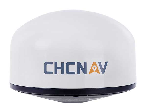
Designed for GNSS networks and monitoring applications
Photo: CHC Navigation
The AT661 geodetic antenna for GNSS networks or monitoring applications supports all current and future GNSS signals, including GPS, GLONASS, BeiDou, Galileo, QZSS, IRNSS, SBAS and L-band. The antenna features both high-gain LNA and wide beamwidth to provide excellent flexibility in applications requiring low-elevation satellite reception and high availability of GNSS signals, especially in obstructed situations. The accuracy of the antenna’s phase center reaches the millimeter level with extremely high stability and repeatability to ensure perfect processing of GNSS data regardless of the length of the baselines. The AT661 withstands all types of weather, including large temperature fluctuations, and is protected by a waterproof radome.
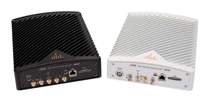
The ThinkRF R5750 Real-Time Spectrum Analyzer with GPS offers high spectral performance, low power consumption, and portability. The R5750 analyzer is built for outdoor, mobile and distributed deployment scenarios, including regulatory and intelligence monitoring, telecom deployment optimization, and RF application development. Users can deploy units in a variety of network architectures, analyze signals in real-time or later, and easily integrate with leading software applications to conduct demodulation or deeper analysis of signals up to 27 GHz. The R5750 analyzer includes embedded GPS for time and location data, and comes with an optional IP66 rating for increased durability and ruggedness in difficult environments.
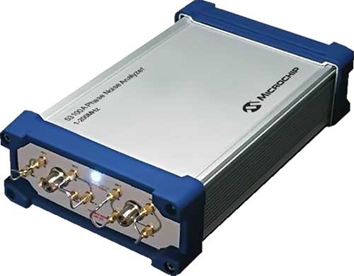
The 53100A Phase Noise Analyzer takes precise and accurate measurements of frequency signals, including those generated by atomic clocks and other high-performance frequency reference modules and subsystems. It combines timing technologies in a small, high-performance measurement instrument designed for engineers and scientists who rely on precise and accurate measurement of frequency signals generated for 5G networks, data centers, commercial and military aircraft systems, space vehicles, communication satellites and metrology applications. Up to three separate devices can be tested simultaneously using a single reference, enabling higher capacity for stability measurements.
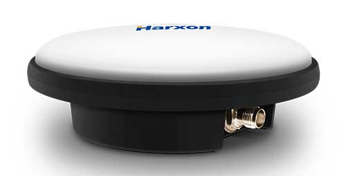
The IP69K ruggedized HX-CVX600A antenna provides end users with millimeter accuracy, durability and productivity. The antenna is designed for applications subject to high shock and vibration environments such as machine control. Integrated with reliable signal tracking and strong anti-interference performance, the Harxon HX-CVX600A offers full support for reliable and consistent satellite signal tracking, including GPS, GLONASS, Galileo, BeiDou, QZSS, IRNSS and SBAS, as well as L-band correction services. Its stable phase center adopts multipoint feeding technology, exceptional low-elevation satellite tracking with symmetric radiation patterns, high gain with ultra-low signal loss, as well as outstanding wide-angle circular polarization. The aerodynamic enclosure withstands exposure against dust, rain, splash or sunlight.
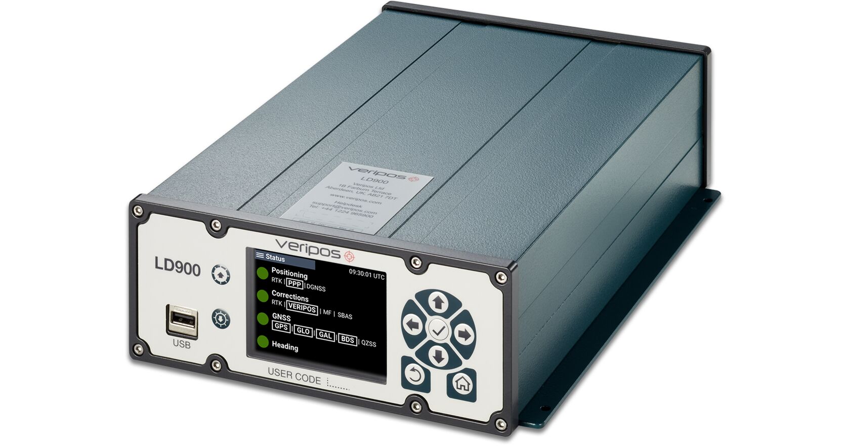
The LD900 is a quad-band GNSS receiver capable of tracking GPS, GLONASS, BeiDou, Galileo and QZSS constellations to provide reliable and accurate positioning. The LD900 also receives L-band signals on multiple channels, providing access to Veripos’ worldwide independent correction services. Using the independent L-band RF input on the LD900 allows the connection of a dedicated L-band antenna ensuring optimal reception of correction services, especially at high latitudes. Veripos provides accurate and reliable positioning for all marine applications via their redundant positioning and multi-frequency precise point positioning (PPP) Apex and Ultra services. The Apex5 correction service utilizes all GNSS constellations delivering 5cm positioning accuracy for use in the most demanding offshore applications. Real-time kinematic (RTK) corrections can be utilized by the LD900 for applications where this service is required. The intuitive color display and navigation menu makes setup, configuration and system status monitoring simple. The display also helps troubleshoot issues with the LD900, allowing faults to be quickly diagnosed and resolved. The LD900 can also be configured remotely through the Veripos Quantum software.
The edge-to-cloud IoT platform Particle is offering a new tracking system that allows organizations to track the locations of a wide variety of mobile assets. Particle’s Tracker system-on-module (SoM) provides a powerful GNSS, microcontroller and advanced peripherals in a compact form factor. Tracker SoM serves as a starting point for organizations that require a tailored tracking solution for sophisticated applications, as well as a fully certified foundation for OEMs developing commercial products. All of the company’s tracking solutions come with a high-gain GNSS antenna accurate to 1.8 meters. The field-ready solution is configurable and can track the real-time location of critical assets and capture additional intelligence via sensor data including temperature and acceleration as well as remotely controlled mobile equipment and vehicles.
Designed in Europe, now available in North America
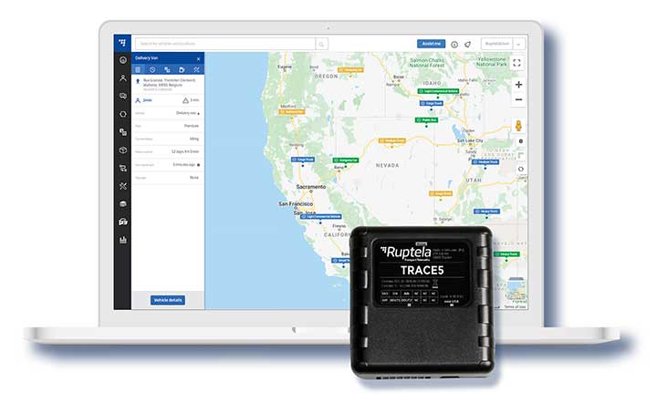
Photo: Ruptela
The Trace 5 plug-and-play GPS-based automatic vehicle location (AVL) tracker and multifunctional fleet management platform TrustTrack provide a ready-to-use telematics solution. The Trace 5 GPS tracker has LTE Cat M1 (4G) connectivity and an integrated battery. TrustTrack is an advanced telematics platform for businesses to manage transport resources. It connects dispatchers and drivers and enables real-time monitoring and drivers’ management. It also generates trip reports.
The HawkEye 5500 is the a dual-mode real-time tracking and vehicle management system that supports Iridium, GPS and 2G/3G/LTE. A GNSS/Iridium antenna is included in the kit. The HawkEye 5500 offers full integration of on-board systems, support for both light and heavy-duty vehicles, two-way messaging, a remote emergency switch, collision detection, audible alerts, RFID and Bluetooth driver identification and customizable application integration. It provides global always-on coverage with high-resolution tracking and communication. Users can customize reporting rates based on movement or location and provide driver feedback when safety violations occur. All operations are tracked via Blue Sky Network’s portal, SkyRouter, which allows for effective high-security command and control of fleets anywhere on the planet.
For infrastructure, mining, forestry, construction
Photo: Kaarta
The Stencil Pro, now in beta testing, is a professional-grade mobile mapping platform with dimensional and visual fidelity. The all-in-one system can scan, process and view captured data in real time. It offers panoramic high-definition 4K imagery and colorized point clouds, and is optimized for both indoor and outdoor lighting. Its simultaneous localization and mapping (SLAM) capabilities enable it to operate in GNSS-denied areas such as indoor, underground, under thick canopy, or in urban canyons. However, it is also fully geo-enabled with an integrated Trimble BD-990 receiver, AV-28 antenna and a range of other third-party GNSS antennas. It supports accuracy enhancements through live RTK/NTRIP processing as well as PPK corrections. GNSS positioning data is used to align and geo-register data for accuracy. The onboard GNSS and color cameras are fully integrated into real-time capture. If a colorized point cloud is not required, or GNSS is not available, reliance on other sensors is seamless.
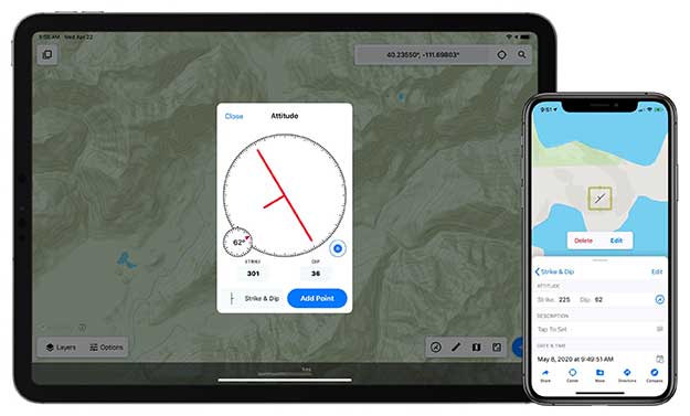
Touch GIS is a powerful mobile app for field data collection and visualization. Version 1.3 features a digital clinometer to assist field geologists in recording strike and dip readings as well as a new attitude attribute type, which makes it easy to record and display these readings on the map. Touch GIS has powerful file support for industry-standard types, offline mapping capabilities, and accurate drawing tools for points, lines and polygons.
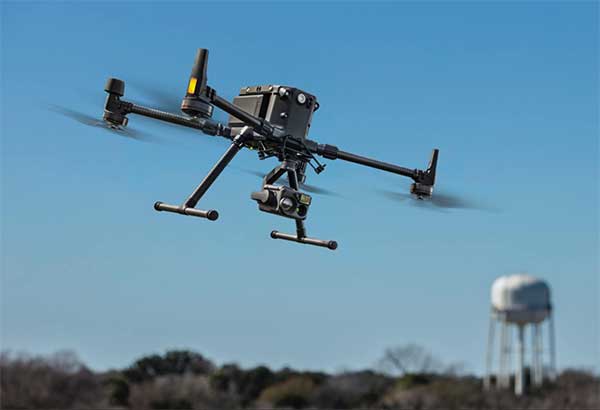
For precise aerial inspections and data collection
The Matrice 300 RTK UAV. (Photo: DJI)
The Matrice 300 RTK is DJI’s most advanced commercial drone platform to date. It integrates modern aviation features, advanced artificial intelligence capabilities, a six-directional sensing and positioning system and a UAV health management system. It has 55 minutes of flight time. The drone platform has AES-256 encryption and an IP45 weather-resistant enclosure. A built-in all-new OcuSync Enterprise transmission system provides a triple-channel 1080p video transmission signal reaching up to 15 kilometers away. The M300 RTK can support up to three payloads simultaneously and up to a total payload capability of 2.7 kg.
Robust positioning in demanding industrial environments
Photo: Septentrio
The AsteRx-i D UAS combines centimeter-level positioning with 3D orientation, enabling automated navigation of aerial drones and robots. It is compact and lightweight, with a high-performance inertial measurement unit from Analog Devices integrated directly into the receiver board. Its small form-factor combined with exceptionally low power consumption results in extended battery life and longer flight times. Both single-antenna and dual-antenna versions are available. The single-antenna version provides a lightweight solution optimizing the system size, weight and power (SWaP). The dual-antenna version is designed for machines that need reliable heading from the start.
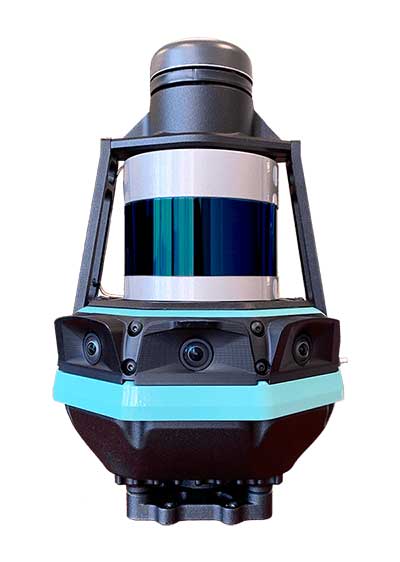
SLAM-based mobile mapping with integrated 360° color is a rugged, geo-enabled, high-density and versatile workhorse
Photo: Kaarta
Kaarta, an innovator of real-time mobile 3D reality capture, has announced beta testing on Stencil Pro, a versatile professional-grade mobile mapping platform with dimensional and visual fidelity.
According to a Kaarta press release, “Whether on the road or on a job site, in a warehouse or an office, an underground mine or in the woods, along a utility corridor or a railway, the multipurpose Stencil Pro mobile mapping system is ready to take on the most challenging environments with impressive speed, providing accurate and visually stunning results.”
An all-in-one system to scan, process and view captured data in real time, Stencil Pro offers panoramic high-definition 4K imagery and colorized point clouds. With robust surround-view perception in a wide range of light conditions, Stencil Pro is optimized for both indoor and outdoor performance.
Featuring a 32-line high-density, low-noise lidar with a range of 120 meters (nearly 400 feet) and a data rate of 600,000 points per second, Stencil Pro produces a highly accurate 3D model in minutes.
With an IP65 rating, Stencil Pro is safeguarded against adverse elements such as dirt, dust, fog and rain, making it the ideal tool for infrastructure mapping, mining, forestry, earthworks, construction and other harsh environments. Stencil Pro’s rugged and versatile design is adaptable to many environments, capturing data amidst poor weather, dusty work environments, and below-ground cavities or when mounted on vehicles, locomotives, ATVs and other platforms.
Like all Kaarta systems, Stencil Pro’s simultaneous localization and mapping (SLAM) capabilities means it operates in GNSS-denied areas such as indoor, underground, under canopy, or in urban canyons. However, it is also fully geo-enabled for the many applications such as street, corridor and rail mapping where the addition of a GNSS signal is highly beneficial.
Stencil Pro integrates the Trimble BD-990 receiver, AV-28 antenna and a range of other third-party GNSS antennas. It supports positioning accuracy enhancements through live RTK/NTRIP processing as well as PPK corrections based on data provided by the NOAA CORS network or a user-supplied base station.
GNSS positioning data is used to align and geo-register data, providing global accuracy and further enhancing the fidelity of large area scans and long, linear scan paths. With the ruggedized design, enhanced power capabilities, as well as the option of incorporating the industry-leading SLAM accuracy in addition to – or independent of – geopositioning, Stencil Pro has the scale of traditional mobile mappers for a fraction of the investment.
The onboard GNSS and color cameras are fully integrated into real-time capture, allowing for optimization of collected data as well as flexibility in output. The advantage of absolute positioning and accuracy coupled with 360 degree imaging technologies produces a true color, rich and robust point cloud when needed. If a colorized point cloud is not required, or GNSS is not available, reliance on other sensors is seamless.
“Billions of dollars of commercial real estate transactions, construction projects, infrastructure maintenance and natural resource management decisions rely on understanding existing conditions data,” said Kevin Dowling, Kaarta CEO. “Obtaining up-to-date data for these environments is laborious, time consuming and expensive with current methods. Even in the most challenging scenarios, Stencil Pro rapidly provides the answers needed for managers to make informed decisions.”
Stencil Pro is powered by either 100-240 VAC input (or 12V with an inverter) or using its two hot-swappable batteries which last for up to 3 hours of scanning. Stencil Pro’s intuitive user interface makes data capture and processing simple. The user experience includes one-button scanning, real-time scan monitoring and streamlined post-processing options for maximizing data clarity and usability. Remote operation with a touchscreen monitor allows for mounting Stencil Pro on a multitude of transports. When hand-carried, scan status can be started and stopped with the press of a button.
Stencil Pro is built on Kaarta Engine, Kaarta’s patent-pending approach to solving the SLAM problem. Kaarta’s unparalleled expertise in localization – a result of its deep robotics roots – delivers definitively lower drift error than alternative SLAM systems by an order of magnitude. Kaarta’s proven technology, quality, and accuracy is trusted by AEC, geospatial, natural resource management and autonomous mobile robot professionals worldwide.
Limited quantities of Stencil Pro will be available to ship in June. Those interested in being considered for early access to discuss a specific application, schedule a demonstration or review sample data sets can apply for the Stencil Pro Early Access Program.