Easily installed GNSS guidance kits offer access to design and payload data
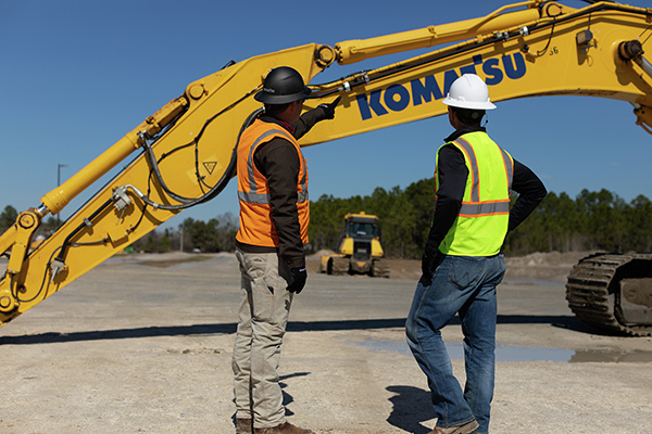
Heavy equipment maker Komatsu is offering Smart Construction Retrofit kits to enable affordable fleet upgrades. With the kits installed, conventional Komatsu excavators become “smart” with 3D guidance and payload monitoring.
Once a conventional excavator is retrofitted, operators no longer have to set up a laser or bench every time the machine moves. The kit’s GNSS receiver determines where a machine is on the job site and what the target grade is. The need for additional labor is reduced because the technology collects and delivers information directly to the operator, so fewer people have to be working on the ground or in an open trench.
Designed to improve grading performance and provide more time- and cost-management tools, Smart Construction Retrofit can bring 3D to most Komatsu excavators in a fleet. The entry-level solution can help bridge the technology gap. It gives operators the latest design data, measures payload volumes and load counts, and allows managers to monitor production from the office by integrating Smart Construction applications.
The payload meter helps prevent overloaded trucks by promoting proper loading weights for on- and off-road vehicles, to reduce the potential for equipment damage and other risks.
Heavy-equipment maker Komatsu has added two new “smart” products to its job-site solutions for construction contractors, Smart Construction Field and Smart Construction Drone.
Smart Construction Field
Komatsu has partnered with Moovila, an experienced provider of project management software, to develop Smart Construction Field, a mobile app that allows contractors to easily record job site activity and analyze operational efficiencies in near real time.
Reports generated by Smart Construction Field can track daily job-site conditions. Task progress can be broken down by labor, equipment and materials, including machine utilization and fuel distribution, receipts, timecards and subcontractor work. Regardless of equipment brand, Smart Construction Field can collect machine data from an entire fleet.
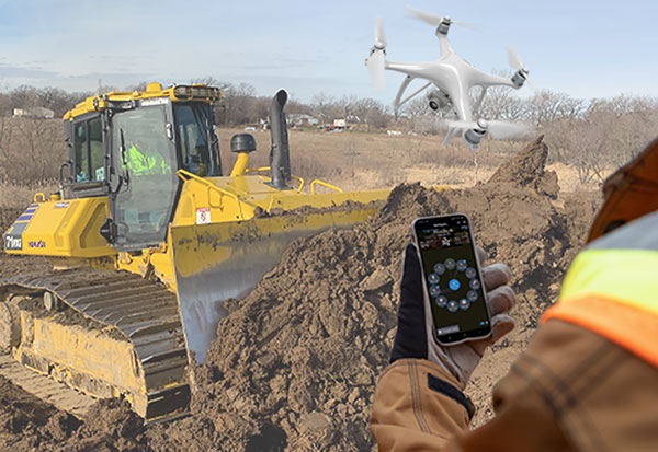
Smart Construction Drone
Smart Construction Drone survey technology collects accurate topography, including quantities for production tracking and billing, without personnel walking the job site to do a manual survey.
Contractors can gather and analyze data throughout each project phase with topographic surveys that incorporate hundreds of thousands of data points. With the capability to take still photos from up to 400 feet above ground level or under bridge decks, Smart Construction Drone can be used as pre-job verification or to keep stakeholders up to date.
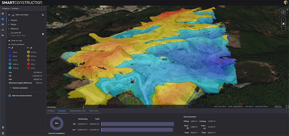
Smart Construction Drone is designed to work with Smart Construction Dashboard. Built to combine data from multiple sources into one comprehensive picture, Smart Construction Dashboard combines 3D design data with aerial mapping and intelligent machine data, allowing contractors to confirm quantities and visualize job-site progress.
Smart Construction Dashboard is powered by the 3D visualization power and geospatial accuracy of Cesium, a platform that visualizes, analyzes and shares 3D data.
Both Smart Construction Drone and Smart Construction Field are part of Komatsu’s Smart Construction solutions, an umbrella of smart applications created to help construction customers optimize their business remotely, and in near-real time.
“When the Smart Construction group came in, they integrated everything, and the transition felt seamless,” said Kevin Hawkinson, vice president of operations, A.W. Oakes & Son. “Now, we can take the data, transfer it to the machines, get data back from the machines to the office, and utilize all of that information across the board for bidding, customer reference and billing.”
Cesium’s 3D technology will power smart construction dashboard to make construction safer, more efficient and more profitable
Komatsu has officially announced an incoming suite of the company’s Smart Construction solutions, which will include the 3D visualization power and geospatial accuracy of Cesium, a platform to visualize, analyze and share 3D data.
“Together, Komatsu and Cesium are bringing a new era of innovation to the construction industry,” said Rod Schrader, Chairman and CEO of Komatsu’s North American operations. “As experts in 3D data visualization, computer graphics and open-source software, Cesium’s technology will help power our Smart Construction Dashboard.”
Komatsu made the announcement at ConExpo 2020, held in Las Vegas.
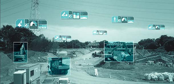
As the key strategic partner for 3D data visualization, Cesium built the company’s Smart Construction dashboard. The dashboard enables users to monitor a construction site from anywhere in the world, see how it changes over time and compare architectural plans with real-world data.
It is compatible with different types of data — collected from sensors on individual construction machines, drone surveys, or computer generated files like BIM/CAD models — allowing users to visualize them all in a single scene within a web browser, as well as calculate precise measurements for cut and fill, slope, contours and more.
As Komatsu noted today, the worldwide construction industry is on the cusp of rapid change and innovation driven by technology. Collecting data from people and machines — and connecting all of it across an open platform — optimizes processes and delivers insights that will enable customers to make data-driven decisions.
Komatsu chose to partner with Cesium because of its powerful 3D visualization engine and accuracy in tying data to precise locations on the globe. Cesium’s ability to keep millimeter-level accuracy while tracking satellites in complex orbits was important to attain the level of precision Komatsu’s Smart Construction initiative demands.
“We believe in Komatsu’s vision to create construction sites that are safer and more efficient through Smart Construction.” said Cesium CEO Patrick Cozzi. “We are proud that visualization and analytics with the hallmark precision of Cesium will provide technology for the industry’s digital transformation.”
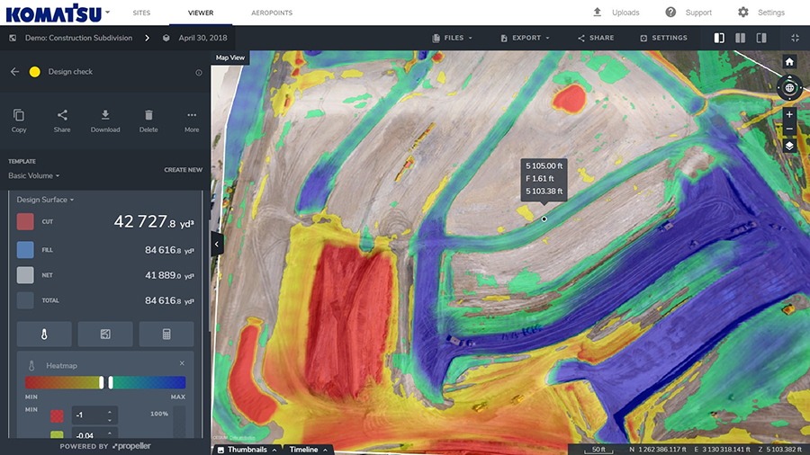
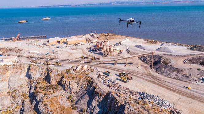
Komatsu America Corp. and Propeller Aero Inc. are partnering to boost the efficiency of construction job sites using drone-powered mapping and analytics software.
With drones becoming an increasingly common worksite tool, Komatsu has identified aerial mapping and analytics as a key component of its Smart Construction initiative — a range of integrated hardware and software products designed to offer an end-to-end workflow for each phase of construction.
Komatsu America Corp. spent several years testing various commercial drone mapping and analytics products in North America. In Propeller, Komatsu found a robust product suited to meet the needs of modern construction operations. Propeller expertly balances ease-of-use with survey accuracy and reliability, Komatsu said.
Propeller’s processing machinery crunches thousands of drone images in hours, and delivers the results as a cloud-based 3D model to the user’s desktop or tablet. From there, powerful collaboration and analysis tools let users perform height, volume and slope calculations, and measure change over time to confirm that a project is on track, the companies said.
(Image: PRNewsfoto/Propeller Aero)
Propeller’s technology platform supports multiple coordinate systems, including local site calibrations. This allows personnel to capture up-to-date survey data expressed in the specific geospatial coordinates they already use on that job site. Local grid support is crucial for ensuring drone-captured maps and models match up with plans and previous surveys.
“A Komatsu Smart Construction jobsite by definition is technology enhanced and production optimized,” said Jason Anetsberger, senior product manager at Komatsu America Corp. “Adding Propeller Aero as one of our key partners gives our North American distributors and customers exceptional capabilities to achieve this standard in the aerial mapping space. Propeller combines simple, yet powerful analysis tools with accurate and fast site visualization.”
“Worksites are starting to see the real business value of accurate, up-to-date drone data,” said John Frost, vice president of business development at Propeller. “We drive that value through workflows that enable everyone to understand who’s moved what material, how much, and where. It’s all about empowering worksites with the information they need to make data-driven decisions to reduce costs, ensure quality, and use resources efficiently. Now more than ever, stakeholders on site, or in the head office miles away, can stay up-to-date with exactly what’s happening on the ground.”
“Anyone can fly a drone — it’s what you do with the data that makes an impression,” said Chris Faulhaber, smart construction business manager at Komatsu Equipment Co. “Propeller provides fast, accurate data processing via a web platform that is unparalleled. The platform is easy to use, facilitates healthy collaboration and delivers vital information quickly — so everyone can work together better and faster than anticipated.”
As the days tick down towards the coming AUVSI Xponential convention in Denver April 30 to May 3, new UAV/UAS developments and applications continue to appear, indicating that this industry could be moving from startup into the beginning of a growth phase.
Skycatch and DJI high-precision drones for Komatsu
The construction industry has always been one of the preeminent areas that require medium- to high-precision surveys. And Komatsu has become one of the world’s leaders in machine automation for the construction site.
Now Komatsu has committed to the automation of site surveys using drones, which ultimately appears to be packaged as a turnkey service for construction companies.
Komatsu aims to show up at a site with all the necessary automated construction machinery and a small staff of automation experts. The experts will survey the site using Skycatch drones and manage the construction for the contractor.
Skycatch drones will survey construction sites with existing RTK networks. (Photo: Skycatch)
Skycatch, based in San Francisco, California, has teamed with Komatsu, who has apparently invested financially in the company and purchased around 1,000 Explore1 drones manufactured by DJI from Skycatch.
Explore1 is actually a modified Matrice 100 DJI drone with special additions. A Skycatch onboard computer links GPS real-time kinematic (RTK) high-precision positioning with a gimbal-mounted 20-megapixel high-resolution camera and the flight computer, resulting in centimeter-level geocoded data.
The big deal is that the system uses existing RTK networks.
Komatsu has been using Skycatch systems for more than three years. The Explore1 system is a combination of all the lessons learned on ease of use and time to collect usable data. Explore1 is used to digitize construction sites during planning, construction and completion.
NASCAR drone protection
It’s unfortunate, but nowadays there always seems to be heightened awareness that events where lots of people gather may present ideal opportunities for possible terrorist attacks. And there has been much made of the possibility that UAVs may be included in the next wave of offensive means for terrorists to inflict civilian casualties on the Western world.
So it’s comforting to hear that for the recent NASCAR race in Fort Worth, Texas, a number of security organizations decided to take the precaution of installing drone countermeasures for the event.
DroneGun, part of the DroneShield anti-UAV system. (Photo: DroneShield)
At the Fort Worth race, the Texas State Department of Public Safety, the Denton County Sheriff, the Fort Worth Police Department, the Texas Forest Service and the Texas Rangers used DroneShield anti-drone systems for the protection of the 2018 Monster Energy NASCAR Cup Series at the Texas Motor Speedway on April 8.
DroneSentinel for drone detection, DroneSentry used for integrated detection and defeat, and DroneGun drone interception were all deployed to determine where drones may be operating and to intercept them if required.
This appears to have been the first known live operational use of all three products by U.S. law enforcement to provide “peace of mind in the aerial domain,” as expressed by an officer about the event.
No bees? Just call for a drone
I’m always frustrated by the fruit tree in my backyard — it absolutely insists on flowering in March when there seems to be more high winds than at any other time of the year, so most of its blossoms are blown to the ground. It’s a mature tree, and you would imagine that it should have learned by now.
But when it is calm and warm, only a few butterflies and birds seem to show any interest. I hardly ever see any bees buzzing around and doing their pollinating thing, and so fruit is hard to come by later in the year.
I’ve thought of borrowing my wife’s make-up brush and dabbing my way round the flowers, but the neighbors, or my wife for that matter, might see me and call the cops to get me taken away…
So I was quite interested when I saw that an outfit called DropCopter, based in Corning, California, is setting about pollination using customized drones. DropCopter basically supplements lost bees by flying over flowering fruit trees and dropping pollen on their blossoms using a drone.
This UAS start-up has initiated a drone pollination service which uses automated multi-rotor drones to dust almonds, pistachios and cherries, boosting crops by up to 15 percent! It seems that fruit producers can rent bees when it comes to pollination time, but bee-rental costs have apparently soared recently. Growers may have been paying up to $180 for one hive to be relocated among their fruit trees. These costs have been cutting into margins and raising the price of fruit at the store.
Enter DropCopter to alleviate pollination problems and restore profit margins for the growers.
DropCopter is using some funding provided by GENIUS NY sponsorship to operate its patent-pending pollination system during nighttime over local New York orchards. Bees don’t like the colder night temperatures, so DropCopter can double the pollination time by operating at night while the bees work the day shift.
But where the heck does DropCopter find all the pollen necessary to fill its pollen distribution containers on its drones? The mystery of fruit pollination still puzzles me.
Range of novel UAV applications grows
So, it’s quite a range of interesting drone applications: automated site survey using drones and a suite of Skycatch processing and data-delivery software; anti-drone protection systems becoming commonplace at larger events; and nature getting a helping hand from pollinating drone systems… Who would have ever thought we’d be seeing these novel, innovative drone solutions?
But, then again, who would have ever expected in the pre-2000 timeframe all the applications that GNSS alone has managed to open up?
Komatsu plans to introduce NVIDIA graphics processing units (GPUs) to its SmartConstrution jobsites. The GPUs will communicate with drones from Skycatch, a Komatsu partner, which will collect 3D images, generate terrain data and “visualize” site conditions.
Komatsu is deploying the artifical intelligence (AI) project as an extension of its SmartConstruction initiative in Japan; the drone-assisted, automated equipment service was launched to alleviate the burden of the country’s severe shortage of skilled workers.
The company has deployed SmartConstruction at than 4,000 jobsites across the country, and the AI extension will be integrated into those sites.
Working with NVIDIA, OPTiM Corp. — another Komatsu partner and an internet of things management software company — will provide an application to correlate terrain data to jobsite workers and construction machines for visualization.
Enter Jetson. At the center of this collaboration is the NVIDIA Jetson artificial intelligence platform. When Jetson, which works with NVIDIA’s cloud technology, is installed in construction machines, it will be able to provide 360-degree images, enabling prompt recognition of workers and other machines nearby. The technology could potentially decrease fatalities that result from workers being struck by an object, piece of equipment or vehicle.
Jetson will also be used with the stereo cameras installed in the cabs of construction equipment, and will recognize continuously changing jobsite conditions on a real-time basis, to better provide accurate instructions to machine operators.
Future plans call for use not only for automatic control of devices, but also for high-resolution rendering and virtual simulation of construction and quarry jobsite operations.
The PC210LCi-11 is designed to increase jobsite efficiency. (Photo: Komastu)
Komatsu America Corp. has launched the PC210LCi-11 intelligent machine control hydraulic excavator.
This second-generation PC210LCi leverages the proven track record and success of the pioneering PC210LCi-10, while adding machine-control joystick functionality.
The technology offers up to a 63 percent improvement in excavating efficiency over a standard PC210LC-11 and traditional stake-plus-grade-checker methods, the company said.
The extra efficiency can save time and money by minimizing the need and expense of grading dozers and grade checkers. It also minimizes the costs associated with over-excavating, including extra materials, fuel and time. It saves time wasted waiting on grade checkers and over-excavation to finish jobs and potentially collect on-time or finish-early project bonuses.
Key features of intelligent machine control technology include:
Full 3D GNSS Capabilities: Not limited like 2D only systems, the PC210LCi-11 features full 3D capabilities, allowing it to dig to grade everywhere on the jobsite a 3D GNSS dozer can.
Work Equipment Automation: GNSS technology tied into machine hydraulics to allow actual automation of work equipment functions — not just the indication/manual-only operation typical of aftermarket offerings.
Machine Control Function Enabled Joysticks: Frequently used machine control functions are now located on the operator’s control lever for increased convenience and comfort.
Stroke Sensing Hydraulic Cylinders: No delay position readout with our proven, robust technology, validated in thousands of machines worldwide.
Intelligent Guidance: Advanced features such as facing angle compass and minimum distance bucket control are delivered in a simple and intuitive manner, with a class-leading 12.1” touchscreen display.
Factory Integrated: Intelligent Machine Control technology factory installed, integrated into the base machine, and validated to the Komatsu quality standards.
“The excavator is productive and precise enough to be a fixture on jobsites from basement and foundation pads to utility work,” said Sebastian Witkowski, product marketing manager for Komatsu America.