Tag: KVH

  • KVH Launches TACNAV 3D Inertial Nav System with Embedded GPS/GNSS

    KVH Launches TACNAV 3D Inertial Nav System with Embedded GPS/GNSS

    TACNAV-3D-KVH-O

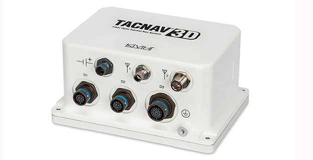
    KVH Industries has introduced TACNAV 3D, a highly accurate inertial navigation system designed for battlefield vehicles, at Eurosatory 2014, an international defense and security industry trade show in Paris, France.

    The TACNAV 3D system is the latest product in KVH’s TACNAV line of tactical navigation systems, and will be on display in the KVH booth (Stand J531, Hall 6) at Eurosatory through June 20.

    The fiber-optic gyro-based TACNAV 3D inertial navigation system provides full three-dimensional navigation and an embedded GNSS. Its modular tactical design and flexible architecture allow it to function as either a standalone inertial navigation solution or as the core of an expandable, multi-functional battlefield management system. It is designed to provide navigation for light armored vehicles, both wheeled and tracked, medium and heavy combat vehicles, and main battle tanks.

    The TACNAV 3D system is fitted with an Iridium transceiver to transmit and receive vehicle position, waypoint, and target location to or from a command center or other vehicles, and can receive messages from the battlefield management system to pass on to the command center via the Iridium short duration burst message function. TACNAV 3D can also receive and transmit Ethernet and CANbus signals, and RS-422.

    “For military vehicles operating on the modern digital battlefield, this completely modular package is a vital component for effective battlefield management,” said Dan Conway, KVH executive vice president for Guidance & Stabilization sales. “It is affordable, lightweight, and easy to integrate with any number of existing vehicles, both turreted and non-turreted. With a built-in communications option, TACNAV 3D is designed for short duration burst messaging, which can make a life or death difference to a soldier.”

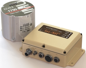
    TACNAV 3D builds upon the success of KVH’s TACNAV family of products, and incorporates the 1750 IMU, which combines 3 axes of KVH’s compact high accuracy DSP-1750 fiber optic gyro (FOG), with three axes of high-performance MEMS accelerometers. The TACNAV 3D system is designed to provide extremely accurate heading, dead reckoning, navigation, orientation, and 100% situational awareness in GNSS-denied environments.

  • KVH Precision Sensors Chosen by Geodetics for Inertial Navigation Systems

    KVH Precision Sensors Chosen by Geodetics for Inertial Navigation Systems

    The Geo-iNAV Advanced is a fully integrated GPS-aided inertial navigation system that utilizes KVH’s 1750 IMU to provide a high-performance navigation solution.
    The Geo-iNAV Advanced is a fully integrated GPS-aided inertial navigation system that utilizes KVH’s 1750 IMU to provide a high-performance navigation solution.

    KVH Industries, Inc., has entered into a strategic partnership with Geodetics Inc., developer of real-time, high-precision position and navigation solutions. The goal is to provide high-performance positioning and navigation products for commercial applications requiring high levels of precision, from unmanned platforms to terrestrial navigation.

    Geodetics is integrating the KVH 1750 inertial measurement unit (IMU) into two solutions: Geo-iNAV Advanced, a GPS-aided inertial navigation system; and Geo-RelNAV, a high-accuracy relative navigation, positioning, and orientation system. The KVH 1750 IMU provides highly accurate 6-degrees-of-freedom angular rate and acceleration data, contributing to the high performance of the Geodetics products while also providing a commercial off-the-shelf (COTS) solution. The COTS designation means the Geo-iNAV Advanced system is available for commercial applications such as manned and unmanned aircraft and control, security platforms on land, air and sea, surface or subsea unmanned vehicles, mobile mapping systems, and photogrammetry and terrestrial navigation.

    As reported April 9, NovAtel, Inc., has added the KVH 1750 as an inertial measurement unit (IMU) option in its SPAN GNSS/INS line of positioning products.

    “Geodetics evaluated a number of IMU technologies, and based on our desire to address the needs of the commercial marketplace worldwide without sacrificing performance, we chose the KVH 1750 IMU, says Dr. Jeffrey Fayman, vice president, planning and development for Geodetics Inc. “With the integration of the KVH 1750 IMU in Geo-iNAV Advanced, you have the best inertial navigation system Geodetics can provide worldwide.” The navigation, position, and orientation accuracy of the Geo-iNAV Advanced is centimeter level, according to Fayman, thanks in part to the high accuracy of the KVH 1750 IMU.

    “KVH is proud to have a strategic relationship with Geodetics,” says Jay Napoli, vice president, FOG/OEM sales at KVH. “The high performance of the 1750 IMU helps enable Geodetics’ systems to deliver ground-breaking accuracy while remaining available to the commercial marketplace.”

    For navigation challenges such as collision avoidance and vehicle-to-vehicle navigation and communication (V2V), the Geodetics Geo-RelNAV system offers a highly accurate, real-time relative positioning and orientation solution that utilizes single- or dual-frequency GPS receivers and the high performance KVH 1750 IMU. The Geo-RelNAV provides precise relative position and orientation between moving platforms such as manned or unmanned air, marine, and ground vehicles. This relative position data is used for such applications as autonomous aerial refueling, autonomous landing, and collision avoidance.

    KVH is one of the only fiber optic gyro manufacturers to control the entire production process, from creating its own specially designed polarization-maintaining optical fiber to packaging its gyros together in advanced systems for inertial measurement, inertial navigation, and attitude heading and reference systems. As a result, KVH’s inertial sensors and gyros offer outstanding accuracy and excellent durability at a lower cost than competing systems.

  • Advanced Navigation, KVH Release Spatial FOG GNSS/INS

    Advanced Navigation, in collaboration with KVH Industries, has announced its new Spatial FOG GNSS/INS. Spatial FOG is a ruggedized GNSS-aided inertial navigation system and AHRS that provides accurate position, velocity, acceleration and orientation under demanding conditions. It combines the new KVH Industries 1750 fiber-optic gyroscope-based inertial measurement unit with magnetometers, a pressure sensor and a dual-frequency RTK GNSS receiver. These are coupled in a sophisticated fusion algorithm to deliver highly accurate and reliable navigation and orientation, the companies said.

    Spatial FOG contains a dual-frequency RTK GNSS receiver that provides 1-centimeter accuracy positioning and supports all of the current and future satellite navigation systems, including GPS, GLONASS, Galileo and Compass.

    A next-generation memory backup system allows Spatial FOG to hot start inertial navigation from its last position in 2 seconds and obtain a GNSS fix in as little as 3 seconds. The memory backup system lasts for the lifetime of the product and will provide backup for 24 hours without power.

    Spatial FOG’s internal filter runs at 1,000 Hz, and data can also output at this rate over high speed RS232 or RS422. This allows for control of dynamically unstable platforms, the companies said. Spatial FOG is also highly tolerant to both shock and vibration thanks to the performance of the KVH 1750 IMU design and advanced filtering.

    Spatial FOG supports a wide range of peripherals including external GNSS receivers, odometers, DVLs, USBLs and NMEA devices. It also supports both industry-standard NMEA output and a binary protocol. Spatial FOG also is easily integrated into retrofits or new designs, said Advanced Navigation.