On Feb. 19, the Finnish government submitted a legislative proposal to parliament to criminalize possession and import of radio-frequency jammers and spoofers, including those blocking GNSS signals
According to Ministry of Transportation and Communications, the amendments would be made to the Act on Electronic Communications Services. The government proposes to amend the provisions on equipment that jam or spoof radio communications.
Unauthorized use of jammers is already banned. The government proposes to criminalize unauthorized possession of jammers, enabling confiscation and improving the authorities’ ability to intervene in the unauthorized possession and import of such devices. The proposal would introduce a distinct definition for jammers, separate from radio equipment, allowing for stricter regulation.
The amendment would set clearer conditions for the use and possession of jammers for the authorities and other authorized parties. The possession and use of jammers for research and product development would be permitted under a license if certain conditions are met.
The proposal would also introduce exceptions for NATO and its member states regarding the right of the Finnish Transport and Communications Agency (Traficom) to check radio equipment or jammers and confiscate them for inspection.
Parliament will first hold a debate on the government proposal in a plenary session. The proposal will then proceed to a committee reading. Following the committee report, the debate will continue in a plenary session.
The Act is scheduled to enter into force on July 1.
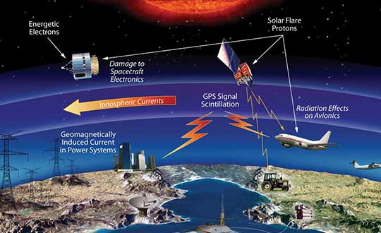
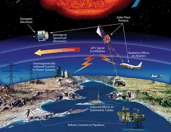
The effects of space weather on critical Earth systems. (Image: NASA)
The United States Congress has passed bipartisan legislation to address how the government deals with threats posed by emissions from the Sun to critical infrastructure such as GPS.
The Promoting Research and Observations of Space Weather to Improve the Forecasting of Tomorrow (PROSWIFT) Act S.881 now awaits signature by the president.
The bill sets forth provisions to improve the ability of the United States to forecast space weather events and mitigate its effects.
It provides statutory authority for the National Science and Technology Council’s Space Weather Operations, Research, and Mitigation Working Group, which coordinates executive branch efforts to understand, prepare, coordinate, and plan for space weather.
The bill directs the Office of Science and Technology Policy, National Oceanic and Atmospheric Administration (NOAA), National Science Foundation, Air Force, Navy, National Aeronautics and Space Administration (NASA), National Security Council, and Federal Aviation Administration (FAA) to carry out specified space weather activities.
The legislation
assigns roles and responsibilities to agencies involved in space weather research and forecasting
ensures agency coordination to better predict severe space weather events and mitigate impacts
calls for coordination between the government and the non-governmental space weather community including academia, the commercial sector and international partners.
Senators Gary Peters (D-MI) and Cory Gardner (R-CO) introduced the first version of the bill in 2016 and a successor passed the Senate in 2017. Reps. Ed Perlmutter (D-CO) and Mo Brooks (R-AL) shepherded it through the House, which passed it Sept. 16.
At first it was a flurry of letters and public statements from U.S. senators and members of the house. Then there was a senate hearing on the topic, and the issue was discussed in several other hearings.
The Federal Communications Commission’s (FCC) approval of a long-standing request by Ligado Networks continues to be controversial. The request was to make terrestrial broadcasts on a frequency near that used by GPS. Broadcasts which, according to analyses by the departments of Defense and Transportation, will interfere with GPS reception for many users.
Now it looks as though Congress is ready to move beyond talk and enact one or more pieces of legislation. These would require an independent technical review of the FCC’s decision and place limits on the ability of Ligado Networks to use the license it was granted.
Congressional interest has been fueled both by member concerns and a regular drumbeat of input from constituents. The recently formed Keep GPS Working Coalition is just one example. It was created from a larger group of more than 70 companies and organizations across a broad swath of industries that has gone on record against the decision and has been supporting congressional action.
National Defense Authorization Act
A primary vehicle for congressional action looks to be the National Defense Authorization Act (NDAA) for 2021. Unlike other “annual” legislation that often gets sidetracked or delayed during election years, Congress has passed an NDAA for each of the past 59 years. As such, it is a particularly powerful tool.
This is doubly so in this case, as the member of Congress that has been the most outspoken critic of the FCC’s decision is Senator Jim Inhofe (R-OK). He chairs the Senate Armed Services Committee that has direct responsibility for the NDAA.
Responding to conflicting claims about the findings of government and private tests, the bill requires the Defense department to contract with the National Academies of Science, Engineering and Medicine for an independent technical review.
Evaluating Potential Impact on GPS
Among other things, the review will compare the different methods of evaluating the potential impact on GPS services from Ligado’s transmissions, and determine which of those was the most effective in guarding against any harm.
The bill also prohibits the Defense Secretary from spending any money to comply with the FCC’s order until the Congress has been given an estimate of the total cost to the department of coping with Ligado’s transmissions.
While the FCC order requires Ligado to modify or replace any government receivers impacted by its operations, the Defense department and others have said this is only a small fraction of the overall costs they would incur.
The bill requires the Defense Department estimate to consider a much larger scope of costs including:
To upgrade, repair, or replace potentially affected receivers
To modify, repair, or replace equipment, pares, associated ancillary equipment, software, facilities, operating manuals, training, or compliance with regulations, including with regard to the underlying platform or system in which a capability of the Global Positioning System is embedded; and,
For personnel of the department to engineer, validate, and verify that any required remediation provides the Department with the same operational capability for the affected system prior to terrestrial operation in the 1525 to 1559 megahertz or 1626.5 to 1660.5 megahertz bands of electromagnetic spectrum.
The House version of the NDAA also provides that:
“The Secretary of Defense may not enter into a contract, or extend or renew a contract, with an entity that engages in commercial terrestrial operations using the 1525–1559 megahertz band or the 1626.5–1660.5 megahertz band unless the Secretary has certified to the congressional defense committees that such operations do not cause harmful interference to a Global Positioning System device of the Department of Defense.”
RETAIN GPS and Satellite Communications Act
Senator Inhofe has also announced he will introduce stand-alone legislation when Congress returns from summer recess. His “Recognizing and Ensuring Taxpayer Access to Infrastructure Necessary for GPS and Satellite Communications Act,” or “RETAIN GPS and Satellite Communications Act,” would require Ligado to modify or replace any receiver, including those used by private citizens, that would be impacted by Ligado’s operations.
This modification would be required before the FCC’s order allowing them to transmit could come into force. Most observers opine that the number of impacted civil receivers in the U.S. is so great that this would effectively deny Ligado use of the frequency.
Introduction of the RETAIN GPS and Satellite Communications Act was planned for before the summer recess. Its delay until after was likely to provide more time to recruit co-sponsors.
GPS Interference a ‘Niche’ Issue
One observer commented that “GPS and the FCC Ligado order are really niche issues. As time goes on, more and more members of Congress will hear about it from constituents and be appalled.”
The delay will also allow time for the mammoth NDAA bill to clear Congress. RETAIN GPS would then have more chance for the spotlight.
Many industry observers have opined that regardless of congressional action, Ligado will struggle to find a successful 5G or other business model that will generate a significant revenue stream from the spectrum.
As public concern continues to grow and Congress responds with legislation, it may turn out that Ligado finally won the battle at the FCC but ended up losing the war.
Coalition’s first action is to endorse Inhofe-Reed legislation forcing Ligado to provide financial relief to consumers, industries and other end users
Five organizations representing thousands of companies and millions of Americans have launched a new coalition to protect end users of GPS following the Federal Communications Commission’s (FCC’s) April 22 decision to permit Ligado Networks to operate a terrestrial wireless network using its satellite spectrum.
Ligado’s planned use of its L-band spectrum — adjacent to bands used by GPS — would threaten the reception capability of hundreds of millions of GPS devices, according to the coalition.
American Road & Transportation Builders Association (ARTBA)
Aircraft Owners & Pilots Association (AOPA)
Boat Owners Association of The United States (BoatU.S.)
As its first action, the Keep GPS Working Coalition will endorse the Recognizing and Ensuring Taxpayer Access to Infrastructure Necessary for GPS and Satellite Communications Act, which is expected to be formally introduced this week by Sens. Jim Inhofe (R-Okla.) and Jack Reed (D-R.I.).
GPS IIIF’s M-Code can be broadcast from a high-gain directional antenna in a concentrated, high-powered spot beam, in addition to a wide-angle, full-Earth antenna. (Artist rendering: Lockheed Martin)
The coalition explained in a press release,
The FCC’s decision threatens GPS reliability for countless consumers, farmers, ranchers, pilots, boat owners, surveyors, construction companies and other private GPS users who will be forced to suffer interference to their GPS devices or to pay to replace them.
The FCC admits in its order that there are cases where both government and private GPS receivers — including those that power aviation, agriculture and other key industries — will suffer harmful interference, but failed to provide a technically feasible and adequate remediation solution for consumer and business end users.
The FCC also failed to conduct an open and comprehensive rulemaking process before issuing the Ligado order, instead circulating a final decision only among FCC commissioners while major stakeholders grappled with the COVID-19 pandemic.
Notably, the FCC ignored established technical standards determining whether GPS devices would suffer harmful interference, instead relying on limited studies using vague and impractical criteria to assess interference with the GPS signal, while disregarding mountains of evidence on the topic under the established methodology.
“In issuing the Ligado order, the FCC threw millions of Americans who depend on GPS in their everyday lives under the bus with undue haste and inadequate consideration,” said Dale Leibach, spokesperson for the Keep GPS Working Coalition. “Alarmingly, the commission also ignored concerns raised by Congress and federal agencies — the experts that rely on GPS to protect our national and economic security — including the Departments of Defense, Transportation, Commerce, Interior, Justice and Homeland Security, as well as NASA, the National Science Foundation, the Coast Guard and the Federal Aviation Administration. DOD has even argued before Congress that the interference from Ligado’s network would put missions and troops at risk. It is a highly questionable decision that benefits a single company and its Wall Street investors at the expense of national and economic security.”
“The Keep GPS Working Coalition will ensure that the concerns of end users are represented in this critical public policy debate, joining the chorus of experts sounding the alarm over the Ligado order’s existential threat to GPS technology and urging the FCC to reverse its decision,” the press release stated.
“In the interest of the agriculture, construction, and other off-road equipment manufacturers, the Association of Equipment Manufacturers is taking a firm stance against the recent FCC Ligado decision,” said Kip Eideberg, Senior Vice President of Government and Industry Relations for AEM. “The FCC decision impacts millions of private GPS devices, many of which are used by farmers, contractors and consumers who depend on a reliable connection to plant, harvest, construct and move goods. We thank Senators Inhofe and Reed for their leadership and for introducing this legislation that will begin to address the wrongdoings the Ligado order will cause, and we urge the FCC to reconsider their imprudent decision.”
“America’s farmers and ranchers rely on precision agriculture technology and GPS so their farms and ranches can be more efficient, economical and environmentally responsible. Expanding broadband access is a top priority for Farm Bureau but not at the expense of losing the accuracy of GPS,” said Zippy Duvall, President of AFBF.
“The FCC’s actions threaten the profound improvements GPS has made possible in the construction industry, including increased efficiency, productivity and improved safety,” said Dave Bauer, President and CEO of the American Road & Transportation Builders Association. “ARTBA stands with our fellow Keep GPS Working Coalition members as we aim to reverse the FCC’s decision.”
“Reliable GPS is critical to aviation safety, a fact that was not adequately weighed by the FCC before reaching its decision. AOPA is grateful for the opportunity to represent aviation stakeholders as part of the Keep GPS Working Coalition,” said Jim Coon, Senior Vice President for Government Affairs for the Aircraft Owners & Pilots Association.
“The GPS technology that America’s boaters rely on every day is once again threatened by the FCC’s recent decision,” said David Kennedy, Government Affairs Manager of BoatU.S. “BoatU.S. is honored to be part of the Keep GPS Working Coalition and looks forward to working with the coalition’s other members to protect this critical technology.”
According to the coalition, in addition to requiring Ligado to satisfy additional conditions prior to the order becoming effective, the bipartisan Inhofe-Reed legislation would ensure the costs incurred by businesses and consumers as a result of the FCC’s decision would be covered by the licensee benefiting from the decision — in this case, Ligado.
“The Keep GPS Working Coalition thanks Senators Inhofe and Reed for introducing the Recognizing and Ensuring Taxpayer Access to Infrastructure Necessary for GPS and Satellite Communications Act, which acknowledges the potential harm to GPS end users caused by the Ligado order and ensures the burden of cost sits squarely where it belongs — on Ligado, rather than our farmers, pilots, boat owners, surveyors or construction companies,” said Leibach. “While we strongly urge the FCC to reconsider its position on this matter, we are deeply grateful to Senators Inhofe and Reed for recognizing the tremendous expense and burden the Ligado order places on American businesses and consumers and providing clear and immediate relief to critical stakeholders.”
For more information about the Keep GPS Working Coalition, visit www.keepgpsworking.com.
The scale and speed of the COVID-19 crisis has left policymakers searching for new tools to address an unprecedented challenge. Everything from faster testing to new treatments to more supplies for frontline providers is needed, and smart deployment of these resources requires an ability to track infections that is not yet available for a problem of the scale of COVID-19.
The recent economic stimulus package passed by Congress — the Coronavirus Aid, Relief, and Economic Security Act (“CARES Act”) – looks to fund this kind of tracking. Among its many priorities, the CARES Act appropriates half a billion dollars to the Centers for Disease Control and Prevention (CDC) for modernization of its public health data surveillance capabilities, and specifically directs the CDC to report to Congress on the development of a “public health surveillance and data collection system for coronavirus within 30 days.”
The legislation does not give much in the way of additional direction to the CDC, meaning that the CDC is likely to think expansively and look for proven models in other highly developed public health systems.
Disease surveillance efforts around the world have taken a variety of approaches, in many cases informed by experience in battling prior pandemics. Public health systems in places such as South Korea, Singapore and China were built on the lessons of the outbreak of Severe Acute Respiratory Syndrome (SARS) and similar conditions over the past several years.
Location-based tracking using GPS provides greater insight and precision than, for example, asking an infected patient to remember and re-trace his or her steps.
Among many other elements, these systems frequently employ GPS-enabled smartphone apps both to gather information and to target alerts to local populations. Location-based tracking using GPS provides greater insight and precision than, for example, asking an infected patient to remember and re-trace his or her steps.
As discussions of similar solutions have begun in the United States, privacy advocates have rightly pointed out the risks inherent in systems that necessarily gather and communicate health information and pair that information with location-based information provided by GPS. But both legally and practically, there need not be an exclusive choice between health information privacy and using GPS and other technology to gather and provide information about COVID-19.
On the legal front, HIPAA broadly exempts disclosures of protected health information for public health activities, allowing disclosures to public health authorities without first obtaining patient consent. Similarly, HIPAA permits data to be de-identified — subject to recognized standards laid out in regulations and guidance — and thereafter shared and used for research purposes, including public health research and similar purposes.
Legal avenues certainly exist to permit significant information sharing about COVID-19 in order to help protect public health.
Furthermore, federal authorities tasked with enforcing HIPAA have already signaled in guidance that they will take a flexible approach to enforcement in order to meet the exigencies of the crisis. Thus, while it is true that HIPAA has not been applied directly to a public health emergency on the scale of COVID-19, legal avenues certainly exist to permit significant information sharing about COVID-19 in order to help protect public health.
On the practical front, HIPAA also points the way to sensible decision-making that balances privacy interests with the needs of the crisis. First, de-identification provides a significant opportunity to share data in a way that is protective of privacy. Second, we should not assume that widespread participation — both in information gathering and information dissemination — must be involuntary in order to be widely adopted.
Smartphones users can — and should — be given a choice before enabling tracking features on their devices, just as they can and should be informed in a transparent way about what data would and would not be shared. HIPAA establishes a “minimum necessary” standard that should provide the guiding principle here: no more information should be shared than is necessary to accomplish the intended objective.
As we search quickly for tools to enable the kind of tracking that we have not undertaken before, we should be careful not to construct a false dilemma between privacy and efficacy — the two go hand in hand. Strong and transparent privacy protections are both possible and necessary to secure the public buy-in that is necessary to make public health surveillance work.
Jeremy Meisinger is a Boston-based attorney at Foley Hoag LLP.
While not as glamorous as mild-mannered Clark Kent holding down a day job while Superman comes to the rescue in time of crisis, there are professional surveyors who work day jobs to perform our duties as practitioners to make a living and participate in association activities in their off-hours to help promote and protect their profession as well as the public they serve.
Many of the hours spent to protect the profession are in the political arena, where the battle for budget dollars and service rights are fought on nearly a daily basis. Because of the reliance of the surveyor on technological advances, the profession has been thrust into the political arena at all legislative levels. The surveyor has been tasked with leading the discussion and help the public understand why significant dollars are needed for funding many different programs to continue with our high-tech trends and lifestyles.
Three of the four presidents on Mount Rushmore started as surveyors — George Washington, Thomas Jefferson and Abraham Lincoln. (Photo: National Park Service)
The role of the surveyor has not been considered political even though several significant U.S. presidents were surveyors in their early careers. Surveyors aren’t particularly known for their public personas, much less their political prowess. Other than states that still have county surveyors, rarely do practitioners stray beyond local municipal government. One is more likely to see a professional engineer or architect as an elected official than a surveyor, but that doesn’t mean the issues we face are any less important.
My current position is a professional land surveyor with a full-time job overseeing a department in a multi-discipline office in a major metropolitan area. Besides being a contributing editor to GPS World through these articles, I also voluntarily wear many hats within our state association and the national surveying society. Several of these hats are government affairs positions at both state and federal levels, as it has become a full-time operation to keep a watchful eye at all governmental levels. From changes in regulations, budgetary revisions and threats to our professionl by outside entities, government affairs take a small army of people to keep abreast of all situations.
This month’s submission is just a snapshot of the current National Society of Professional Surveyors (NSPS) Joint Government Affairs Committee action item list being addressed and monitored through its committee members and a governmental lobbyist. The importance of this list is to give the reader a sampling of the seemingly endless battles being waged on Capitol Hill by NSPS and its members nationwide.
All these issues have GNSS at their heart and will have dire consequences if any of these subjects fall short of their intended marks.
This is not just about the GNSS and how we collect data; it’s also about the necessity of large scale data collection to provide better and safer services to the citizens of the United States and its territories.
Our current datasets and standards for data collection, like our infrastructure, is aging and lacking in detail. Serious upgrades are overdue, so several actions have been put forth to try to rectify the shortcomings.
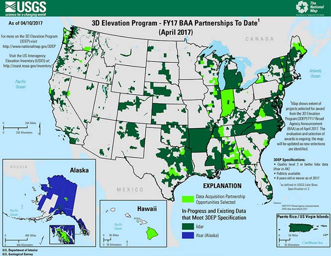
3DEP
Formally known as the 3D Elevation Program, this language was introduced as part of S. 1460 (“Energy and Natural Resources Act of 2017”) by Senator Lisa Murkowski of Alaska. This program is being created so that consistent elevation data, cultivated through many surveying and mapping sources including lidar, will be available for efficient design use throughout the American infrastructure.
While it currently does not have a single line item in any budget, the USGS Budget Summary lists its necessity in the Core Science Systems Program as part of the National Geospatial Program. This program is intended to provide high-quality topographic, geologic and hydrographic data nationwide to assist with further development of energy, transportation, drainage, emergency response and hazard mitigation.
As part of the 2019 President’s Budget, the USGS Green Book also lists having the entire nation covered by an ongoing lidar program by 2033, along with completing a significant amount of data collection by various means in Alaska by 2022, including high-resolution interferometric synthetic aperture radar (IfSAR) necessary for data collection in more difficult terrain.
The Green Book also lists high-resolution hydrographic data to support flood risk management studies, as the frequency of large scale flooding seems to be increasing substantially in more places than ever before. It also includes additional mapping data, programming and functionality for emergency personnel charged with oversight of public safety in times of crisis.
FAA reauthorization
The current FAA authorization bill expires on March 31. The biggest hang up holding up getting the bill reauthorized is privatization of the air traffic controllers, but there are rumors of tightening of UAV rules due to the rapidly growing use of the vehicles for business and personal use.
Surveyors are working with federal and state officials to help implement reasonable rules for use and coverage of the UAV as the field of surveying has been drastically affected by use of aerial vehicles. Many tasks that used to take days now take hours with increase accuracy, so the effects of the UAV will be seen for many years to come.
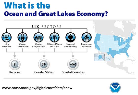
Digital Coast Act
One of the legislative acts that NSPS was a big part of in 2017 was Senate Bill 110, “The Digital Coast Act” which led to the introduction of the companion bill in the House as H.R. 4062. This Act will allow NOAA to perform the necessary actions to actively and effectively monitor all coasts (including the Great Lakes) by various means, including bathymetric and conventional survey methods. This will require services to be performed by public and private surveyors primarily with GNSS capability to provide NOAA with standardized information based upon established datum.
FLAIR Act
The Federal Land Asset Inventory Reform (FLAIR) Act of 2017 was introduced as House Resolution 2199 to help with creating a database of government property nationwide. The Government Accountability Office (GAO) has stated that the management of federal real property has become a “high-risk” item on its list of duties. Management of the number and value of properties has increased to a point that an overall dollar amount of federal buildings and land cannot be accurately determined.
How does the surveyor fit in with this issue? Simple. The U.S. government will need to upgrade its database of existing facilities through having them surveyed for asset management. Part of the requirements for providing these surveys will be completing the work in datums that will be following the geographical databases being designed to contain the parcel and building information. All this data will have geospatial information regarding parcel, address, utilities and functionality of the inventory, so providing the data with the sufficient attributes will become a key role for the surveyor. GNSS data collection will be at the heart of this monumental task.
Geospatial Data Act
As introduced in May 2017, the Geospatial Data Act (GDA) of 2017 is intended to jumpstart the nationwide initiative to develop and coordinate efforts to collect and maintain new datasets of elevation and infrastructure information. It is intended to improve and enhance federal geospatial activities to encourage state and local agencies to participate at the local level.
It is interesting to note, however, that the revised Geospatial Data Act was introduced by the same sponsors that did not include procurement procedures that follow the typical Brooks Act of quality-based selection, and instead relied on bid-based selection commonly found with suppliers. Both bills are being vetted by their sponsors and potential geospatial providers for clarity with ongoing debate going forward.
Hydrographic Services Improvement Act
H.R. 211 bring us the Hydrographic Services Improvement Act to provide NOAA with incentive and funding to standardize surveys desperately needed in waterway areas. Ongoing discussion continues this spring to determine sources of funding and priority of projects.
Infrastructure bill
February brought us the introduction of a significant infrastructure program aimed at improving roads, airports and bridges, with other major improvements across the country. This program is noteworthy in recognizing the need of current geospatial data and inventory of major infrastructure needs. The program sets forth the need for surveying, mapping and geospatial data for planning, design, construction, operations and maintenance for a multitude of projects nationwide. Much more will be discussed regarding the funding and priority of projects as the political year moves on.
LightSquared/Ligado
Readers may remember when the original confrontation with LightSquared began in 2011, and the subsequent battle over the frequency ranges adjacent to the GPS bandwidth. The FCC gave LightSquared initial but conditional approval to move forward with terrestrial-based transmission for 4G cellular transmission for up to 40,000 land-based stations. Testing by private and governmental agencies through 2011 and 2012 proved that LightSquared would greatly harm GPS activity for both public and private use. Once exposed, the conditional FCC approval was rescinded and LightSquared retreated into the shadows…until now.
Reformed as Ligado, it has fresh investors and is making a charge into 5G technology with a revised game plan. While it is also looking to use other spectrums for communication, it once again is dangerously close to other current uses. Couple the proximity of adjacent bandwidth with the intense land-based signal versus a very weak satellite signal, there will be significant overriding by the new user. All of this is still being worked out through the FCC and the Department of Defense, so final resolution is yet to be seen.
IMAGES Act
The National Flood Insurance Program (NFIP), as part of FEMA, is looking to move forward with legislation introduced as Improvement of Mapping, Addresses, Geography, Elevations and Structures (IMAGES) Act (H.R 4905). This act intends to reform the NFIP program by utilizing new elevation data collected through the 3DEP program, which will be combined with other parcel attributes including addresses and structure types. This data will then be combined with refined floodway information to identify parcels that are more susceptible to damage caused by storms and flooding.
New legislation can be a good thing, but only if funding can be provided. This bill could provide a major upgrade to the flood mapping and insurance program, but it will hit a big snag with lack of monetary support. The proposed funding for FY2019 is $100 million, yet the project costs for the FY2018 budget is $178 million. This significant difference will make a large impact on the effectiveness of the program and proposed revamp.
Railroad reauthorization
NSPS has spent several years working with various legislators trying to find the right bill to insert language to require railroads to monument their routes before removing tracks. But with the recent accidents of various rail lines, the spotlight has been put on various factors that cause the incidents and how to eliminate their occurrence.
Positive train control (PTC) systems incorporate geospatial data collected through GNSS, lidar and conventional surveying means to work with operational systems to assess dangerous situations. Surveyors will need to be at the forefront of the necessary data collection so our efforts to continue lobbying for railroad funding will continue.
Net Neutrality Act
A political hot topic the surveyor doesn’t typically think about is net neutrality. Most people think they will be affected by lack of neutrality slowing down their home internet or streaming service, but for surveyors it will be a much bigger deal.
A remarkable number of surveyors and mappers use cellular data streaming to provide a connection to a positional correction service. The throttling of this data will effectively slow down the performance and quality of the positional data, leading to less reliability and productivity. It will also slow down the data interaction of office and field staff exchanging data and image files critical to project productivity and success.
So, when the call goes out to contact your federal representative to protect net neutrality, remember how it will affect your surveying business model and make that call.
How professional land surveying associations get it done
Many thanks to the countless hours put in by the NSPS Joint Government Affairs team, consisting of Committee Chair Pat Smith, NSPS Government Consultant John Palatiello, NSPS Federal Lobbyist John “JB” Byrd and NSPS Executive Director Curt Sumner. This group is constantly monitoring legislative action across the country as well as in D.C. and is quick to respond when action is needed on legislative issues. They do a tremendous job, yet not many see them in action. Hopefully all surveyors will continue to see and feel the benefits of their results.
As simple as the process is, the political world has gotten much more complicated as time marches on. From local municipal offices to Washington, D.C., getting things done through legislation has become a long process that takes patience and plenty of money to get your voice heard. Surveyors are no different than any other profession in that we must stay out in front of issues that affect our physical and business world. The important part is to stay informed and have a voice.
Let’s also remember those three fine individuals, memorialized on Mount Rushmore, who accomplished great things after their stints as surveyors, so anything is possible if we keep our voice in government.
Surveying has evolved into a highly technical professional with GNSS as a backbone method of data collection. With the U.S. government at the center of that technology, we need to make sure we, as the surveying practitioner, stays engaged.
As the 2016 legislative session kicked off this month, the Association for Unmanned Vehicles Systems International (AUVSI) has been tracking all active legislation pertaining to unmanned systems. This year, to provide the best information to its members, legislators, regulators and the media, AUVSI has organized data on all unmanned systems-related state legislation into a sortable, interactive map with details that include a summary of each bill.
Included are bills that place restrictions on police, recreational or commercial unmanned aircraft systems; legislation that forms unmanned systems or autonomous vehicle commissions and task forces; bills that try to treat unmanned technology differently than other information-gathering devices; and bills that place operating limitations on unmanned aerial systems (UAS) in specific scenarios such as preventing all UAS from flying over prisons or from interfering with hunting and fishing.
To date, more than 150 active bills in more than 30 states have either carried over from 2015 or been introduced this year.