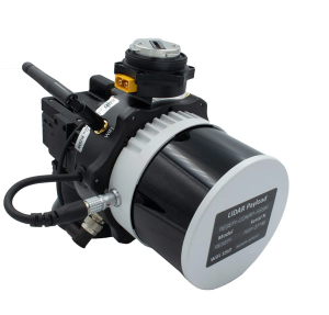
Inertial Labs has released a remote sensing payload instrument. The Resepi Hesai XT32 laser is designed for accurate remote-sensing applications. The Resepi laser can be used with commercially available lidar scanners, including Velodyne, Quanergy, Ouster, RIEGL, LIVOX and Hesai, as well as with UAVs.
Resepi is completely modular, so users have full control for customization. The remote sensing device uses a GPS-aided inertial navigation system with NovAtel RTK/PPK single- or dual-antenna GNSS receiver, integrated with a Linux-based processing platform. It also comes with a 2 TB USB memory drive and has an embedded Wi-Fi cellular modem.
Resepi has 3-5 cm point-cloud accuracy and can reach heights of more than 200 m above ground level. It is compatible with most UAV models; however, it is typically used with DJI M300, DJI M210 or DJI M600 models.
The device is suitable for scanning and mapping, precision agriculture with lidar, simultaneous localization and mapping (SLAM) algorithm development, utility inspection and construction site monitoring. Resepi-supported software includes Hexagon NovAtel, PCPainter and PCMaster.
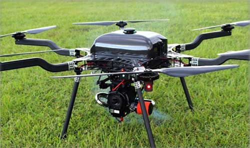
Lidar USA is integrating its UAV scanning systems with the Harris Aerial H4/H6 Hybrid multicopters.
As surveyors and mappers experience growth, they assume larger and larger projects, making longer flight times increasingly important. The Harris Hybrid can provide such flights with lidar and industrial-grade cameras, allowing for far greater coverage in a single flight.
“The beauty of the Harris Hybrid, is that the pilot continues to enjoy the flexibility of a multicopter, availability of fuel, and relatively compact packaging at an affordable price,” said Jeff Fagerman, CEO of Lidar USA. “While it is louder than an all-electric system, for particularly large, rural projects it is a very nice solution.”
Harris Aerial, a drone manufacturer near Orlando, Florida, builds and sells heavy-lift hybrid multicopters. These copters use a small generator running on 95 (or higher) octane fuel to power the UAV for up to 5 hours. The H6 can carry an A-series HD lidar system of 3 kg for 2.5 hours and a V-series of 5 kg up to 1.5 hours.
For the lidar operator, most projects require only one or two flights. On projects that are relatively flat with a clear line of sight to the horizon in all directions, these systems can cover everything legally possible in a single flight.
Lidar USA offers the Harris Aerial H4/H6 Hybrid an integrated package with any Lidar USA scanning system.
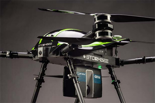
The Faro Focus scanner attached to a Stormbee UAV. (Photo: Stormbee)
3D measurement and imaging company Faro has joined with UAV provider Stormbee to offer an integrated airborne 3D scanning solution designed to quickly gather large area data for crash scene documentation, security pre-planning and military applications.
The integrated solution includes the Faro Focus laser scanner, the Stormbee S series UAV and the Beeflex software suite.
The airborne solution enables wide-area scanning missions, such as highways, train infrastructure, and buildings. While these would take days when scanned from the ground, they can now be completed in just hours without interrupting traffic or setting foot in a zone of interest.
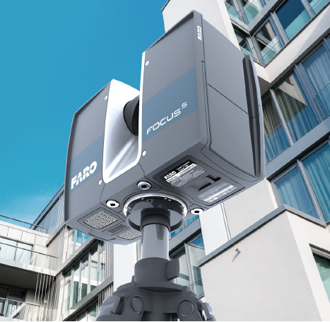
The Faro Focus laser scanner. (Photo: Faro)
The solution further enhances productivity by allowing users to capture complex environments where traditionally would be inaccessible to ground based scanning and levels of accuracy and detail from the air with exceptional.
The data can then download to FARO Zone for crash reconstruction, security pre-planning, military reconnaissance.
The Faro–Stormbee airborne solution has no need for control points, meaning is quicker to start scanning an area compared to other lidar drones. Drone pilots can fly with ease as it goes up to 100 meters (328 feet) in the air. With the drone’s integrated redundancy, even if a propeller or battery fails the UAV still flies.
“Stormbee has developed and validated its UAV credibility from real-life testing in the most rigorous environments,” said Liesbeth Buyck, CEO of Stormbee. “As a result, we are confident that this turnkey solution, that includes the Stormbee UAV and the FARO Focus laser scanner, creates a new reliability and quality benchmark for airborne 3D data capture solutions.”
Users can create centimeter-level accurate point clouds directly from the in-flight data. The user-friendly Beeflex software takes little training to use and can be exported directly into Faro Scene or Faro Zone 3D software for further analysis or to combine aerial scans with the detail-rich data from terrestrial scanners.
The Faro scanner can detach from the drone and be used as a terrestrial scanner or even a mobile mapper. This flexibility allows users to use one scanner in the air, on land or affixed to a vehicle.
Combined with Faro’s Focus laser scanner compact design, IP54 rating and laser technology users can scan a vast variety of scenarios, from large areas (railways, cities), areas with no light (tunnels, burned buildings), and hard-to-document areas (cluttered crime scenes, inside dumpsters).