Tells Space Advisory group spectrum issues a concern for all
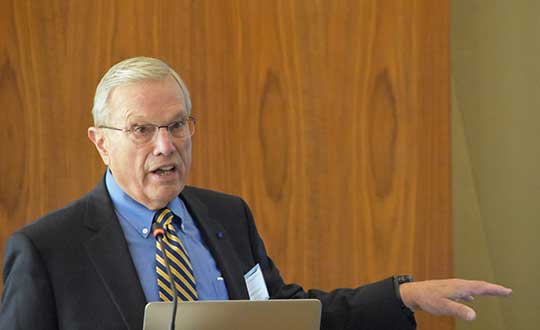
Speaking to a gathering of space industry leaders, Dr. Brad Parkinson, the original chief architect for establishment of the Global Positioning System, outlined the threats to GPS signals posed by a proposal from Ligado Networks that is before the Federal Communications Commission (FCC).
The proposal, which was initially approved, has been pending since 2011 over concerns about its impact on reception of GPS signals.
When asked why the proposal has been pending for so long, Parkinson speculated a combination of the enormous sums of money potentially involved and difficulties for the FCC in arriving at an equitable solution were to blame.
“I hope they find some spectrum for Ligado,” he said. “Just not the spectrum they are asking for.” Referring to the powerful proposed transmissions in frequencies adjacent to those used by weak GPS signals, he said “You don’t want to put a rock band next to a retirement home.”
“You don’t want to put a rock band next to a retirement home.”
Parkinson was speaking to the National Space Council’s User Advisory Group (UAG). The UAG was chartered under the Federal Advisory Committee Act in December 2017. Membership includes the CEOs of Lockheed, Boeing and other companies with interests in space, the Governor of Alabama, five former astronauts, and other leaders in space technology and policy.
This was the first time the UAG’s agenda focused on GPS and positioning, navigation, and timing issues. Parkinson was invited to discuss the activities of the U.S. National Space-based Positioning, Navigation, and Timing Advisory Board. The UAG was interested in learning from the PNT Advisory Board’s experience, and about some of the issues it has encountered over the 15 years since its establishment in 2004.
Parkinson used the PNT board’s experience with adjacent band compatibility and the Ligado proposal as an example of a particularly thorny issue. He said the Ligado issue was an ongoing concern that the UAG should share.
Brad Parkinson shared his concerns over lack of Ligado decision with the National Space Council’s User Advisory Group (UAG). (Photo: Rebecca Zia)
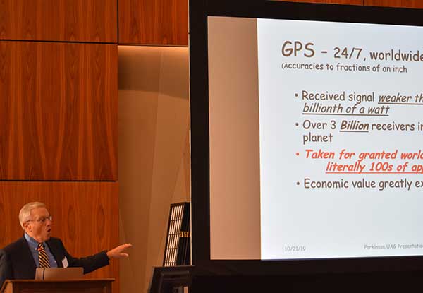
Also that spectrum issues writ large should be of great concern to all users of space as the competition for spectrum from terrestrial users will continue increase. He called the Ligado proposal “a grave threat to GPS,” especially for aviation and high-precision users.
During the course of the presentation Parkinson asked for the UAG’s support of the PNT Board’s recommendations on the Ligado proposal. He also asked the group to endorse the National PNT Executive Committee’s adjacent band compatibility methodology to any future such proposals.
Parkinson’s presentation concluded with a discussion of how GPS is increasingly being used to support activities in space. It has long been used for booster guidance during the initial phase of space flight.
Relatively recent work using side lobe signals from GPS satellites has caused engineers to recognize a Space Service Volume for GPS. This allows use of the signals for mid-course launch corrections, satellite station-keeping, rendezvous, and potentially trans-lunar navigation.
“In partnership with Ligado Networks, we have demonstrated delivery of TerraStar X technology over both satellite and cellular networks to position vehicles with 5-centimeter (2-inch) accuracy in under a minute,” Hexagon stated in a press release. “Combining TerraStar X technology with multiple delivery channels is a significant step towards the future of Autonomous X, where cars, UAVs, industrial vehicles, trains and more will operate safely, securely, reliably and efficiently.
TerraStar X technology is built on the latest precise point positioning algorithms. According to the company, it leverages existing Hexagon capabilities in ground network infrastructure, correction data generation and data packaging for delivery.
By eliminating convergence time while providing high-accuracy global positioning, TerraStar X will form the future of Hexagon’s correction services for safety-of-life applications and Autonomous X.
When combined with automotive-grade GNSS receivers available through Hexagon Positioning Intelligence, the technology allows automotive customers to evaluate positioning performance in real time using data delivered over the cellular network or the L-band frequency using Ligado’s SkyTerra satellite in North America.
Trial networks for customer evaluation are available in California, Arizona and Michigan over satellite or cellular network, and in Germany using cellular delivery. The infrastructure is scalable, enabling timely geographic expansion to accommodate automotive development programs globally.
Commercial solutions designed for the automotive market will be available in 2019.
“Ligado’s expertise in satellite delivery and proactive involvement in this project enabled rapid deployment of our TerraStar X correction technology over the test area,” said Sara Masterson, positioning services segment manager with Hexagon’s Positioning Intelligence division. “Their unique spot-beam technology enables efficient delivery of the higher bandwidth correction data required for this application and adds a delivery method providing continental scale coverage.”
The geostationary Skyterra satellite operated by Ligado uses a 22-meter reflector-based antenna to deliver an L-band signal over North America. Several of the L-band DGPS/PPP service providers, including Terrastar, have used the Skyterra-1 satellite since its 2010 launch to support North American coverage.
Hexagon has been providing highly reliable, precise GNSS corrections under VERIPOS, TerraStar, Oceanix, and SmartNet brands for more than 20 years, the company said. It operates the world’s largest reference station network, consisting of more than 4,500 stations.
“Hexagon is uniquely positioned to offer end to end solutions from correction data generation through to GNSS positioning solutions in the vehicle,” said Brian Deobald, vice president, strategic product and ecosystem development, Ligado Networks. “We are excited to partner with Hexagon on this opportunity to demonstrate the delivery of TerraStar X technology, using high throughput, cost-efficient satellite connectivity to enable superior performance and reliability for autonomous driving applications.”
Ligado. This development has no relationship to the current Ligado Networks petition before the Federal Communications Commission to repurpose some of its mobile satellite systems spectrum to broadcast from ground-based transmitters. That matter is still pending, and there is currently no such signal being broadcast.
Eight years on, and the money generated by a hedge fund still seeks to destabilize the Global Positioning System and the billions of people who benefit from it, whether they create it, administer it, sell it or use it.
That accounts for just about everybody touched by telecommunications and the industrial network, including the brave individuals serving in the military.
For rewards to the few, the U.S. government is lobbied to levy hardship on the many. In the service of that lobbying, the truth is manipulated to suit the ends. Sound familiar?
See this article for facts and findings of years of detailed study of this matter, recounted in the recently released Department of Transportation’s Adjacent Band Compatibility (ABC) Assessment Final Report. That it appears almost a year after all the research and nearly all the analysis was completed suggests that powerful forces are at work, perhaps warring with each other, within the government. Let us hope that the guys and gals with the good hats on can prevail.
The matter now rests with the Federal Communications Commission, an appointed panel not subject to the electorate nor to Congress, whose decisions sometimes carry a scent of influence from hidden quarters. Note particularly the recent ruling against net neutrality, which most agree runs counter to public interest and correlative with private corporate interests.
As our news story states, the ability to use the mobile satellite services (MSS) band for terrestrial services is “limited.” The DOT ABC Assessment, using the 1-dB Interference Protection Criterion of a 1-dB drop in carrier-to-noise density ratio that’s accepted by everybody — specifically, every engineer — on Earth except Ligado Networks, demonstrates conclusively there is no chance the company could actually deploy a viable commercial terrestrial service in the MSS spectrum without disrupting or degrading vital GPS and GNSS services.
The U.S. government and the GPS industry have both expended far too much money and time trying to accommodate a force-fit of a non-compatible use into the bands adjacent to the radionavigation satellite service band, to the benefit of one commercial company’s bottom line.
It’s high time for this nonsense to stop. Nobody, least of all the government and the GNSS industry, owes Ligado anything.
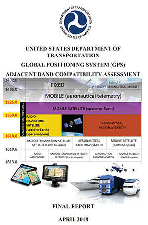
The culmination of several years of test and analysis conducted by the U.S. Department of Transportation, the assessment will play a key role in the Federal Communications Commission’s upcoming decision on a proposal from Ligado Networks.
The long-awaited Final Report for the U.S. Department of Transportation’s Adjacent Band Compatibility (ABC) Assessment was released on April 26.
The report is the culmination of several years of test and analysis conducted by the DOT, with input and assistance from the public and federal agency stakeholders. Though not explicitly motivated by it, the assessment appears to be responsive to the Positioning, Navigation, and Timing (PNT) Executive Committee’s (EXCOM’s) Jan. 13, 2012, memorandum to the National Telecommunications and Information Administration (NTIA) that sought to develop metrics to inform commercial non-space proposals for use of frequency bands adjacent to those used by GPS, so that existing and evolving space-based PNT services “vital to economic, public safety, scientific and national security needs” were not affected by implementing such proposals.
The assessment will likely play a key role in the Federal Communications Commission’s upcoming decision on a proposal from Ligado Networks to add an extensive complex of powerful ground transmitters to its system, broadcasting on frequencies allocated for satellites.
Open and Transparent. Two key attributes of the ABC assessment were that it was conducted openly and transparently, with numerous public workshops announced via the Federal Register, and it was agnostic to any particular proposal for use of bands adjacent to GPS/GNSS services. The approach chosen by DOT in performing its assessment was to develop maximum tolerable effective isotropic radiated power (EIRP) levels that could be transmitted at differing frequency offsets from the GPS L1 center frequency.
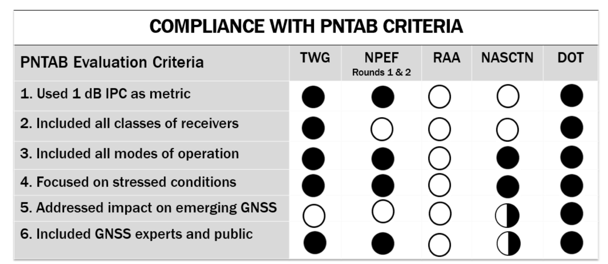
The term “adjacent” in this regard is a bit of a misnomer in that the assessment range extended to 100 MHz on either side of the GPS L1 center frequency of 1575.42 MHz. This approach was recently validated by the National PNT Systems Engineering Forum (NPEF), which found the ABC assessment was the only one of five test and analysis efforts conducted since 2011 on adjacent-band terrestrial operations that met all six of the test criteria recommended by the experts serving on the National PNT Advisory Board. The NPEF analysis is available here.
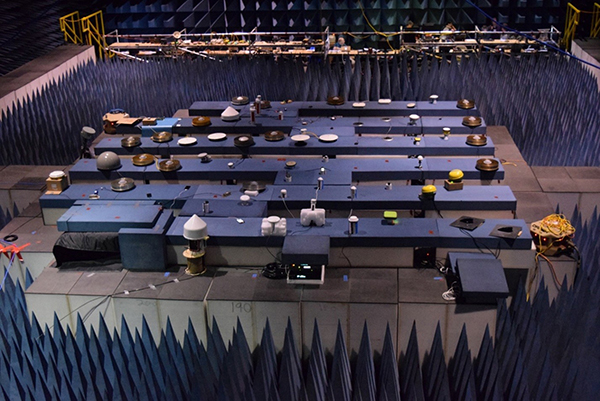
Measurements on 80 civil GNSS and GPS receivers were performed at White Sands Missile Range (WSMR) in New Mexico. The Air Force conducted a prior week of testing on military GPS receivers at WSMR, and while the results of that testing are classified, an Air Force briefing at the November 2017 PNT Advisory Board meeting indicated the military receiver test results supported the conclusions drawn by the DOT ABC assessment. Certified aviation GPS/GNSS receivers were analyzed by RTCA Inc. and are being analyzed by the FAA in terms of determining power levels in adjacent bands that don’t exceed FAA Technical Standard Orders. However, the overall ABC assessment indicates that certified aviation receivers are not the limiting case for tolerable interference from adjacent-band services to GPS and GNSS receivers.
Test Procedures
Compatibility assessment for the civil receivers consisted of conducting the initial measurements at WSMR for six categories of receivers: aviation (non-certified), cellular, general location/navigation, high-precision, timing, and space-based receivers. These were evaluated to determine what DOT called Interference Tolerance Masks (ITMs) for each category of receiver and each receiver tested. The ITMs define the maximum aggregate interfering power that can be tolerated by a given GPS or GNSS receiver. The ITMs are based on the internationally accepted Interference Protection Criterion (IPC) of a 1-dB drop-in carrier-to-noise density ratio (C/NO) for the receiver, or, equivalently, an interference density-to-noise ratio (IO/NO) of –6 dB. This 1 dB IPC standard, which NTIA directed to be used in the NPEF evaluation of the original LightSquared (now Ligado) adjacent-band proposal in late 2011, is explained in great detail in a white paper the Air Force made publicly available in 2017.
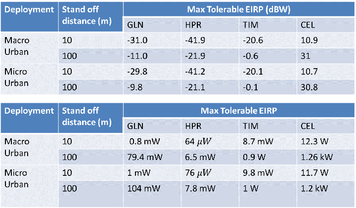
The assessment then developed, with input from the public at several workshops convened by the DOT, use cases to determine how close a receiver for a particular GPS or GNSS application might be to a base station or handset of a commercial terrestrial service in an adjacent band. Proximity distances of 10 and 100 meters were selected from these use cases, and maximum tolerable transmit EIRP levels for a given frequency offset were determined; see Figure 1. The high-precision receivers (HPRs) were the most susceptible to interference from terrestrial operations in the adjacent bands.
Figure 1. Maximum tolerable power level for GPS/GNSS receivers at 1530 MHz. (Table: DOT)
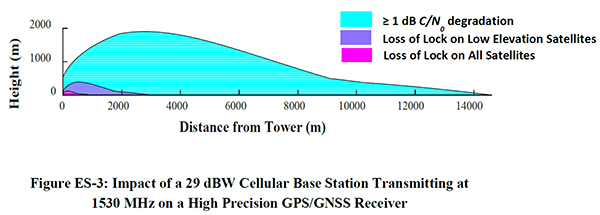
One thing that seems clear is that, with tolerable transmit power levels in the milliwatt and microwatt range, the potential to use the bands near GPS frequencies for commercial terrestrial wireless services may be limited. Illustrating that point further, the assessment shows that, based on the assumptions in the study, HPRs can be affected at distances beyond 14 kilometers (see Figure 2), and that loss of lock for low-elevation satellites can occur at distances of up to 3 kilometers from a base station providing terrestrial services using characteristics adopted internationally in the International Telecommunication Union (ITU) study groups.
Figure 2. Impact of a 29-dBW cellular base station transmitting at 1530 MHz on a high-precision GPS/GNSS receiver. (Chart: DOT)
Moreover, the assessment determined that the potential interference to other GNSS systems may be more problematic, noting that “the levels that protect all GNSS signals can be as much as 15 dB lower than those needed to protect L1 C/A signals from base station emissions with an average difference of 3.5 dB across all frequencies and five categories considered.”
Galileo’s Role. Since 2013, according to a Public Notice from the FCC, the European Commission has sought a waiver of FCC rules that require licensing of receivers operating with foreign satellites so that Galileo service can be provided in the United States. The FCC has yet to act on this waiver request, which was issued in a January 2017 Public Notice, despite overwhelming public support and a positive recommendation from the Executive Branch in 2015.
Figure 3. Bounding masks for each category corresponding to the 10 MHz LTE interference signal and L1 C/A GPS signal: general aviation, general location and navigation, high precision, timing, space-based, cellular. (Graph: DOT)
Conclusions
It is well known that all receivers take in some power from signals transmitted in nearby frequency bands. Considering this fact, the ABC assessment is relatively unique in that it examines the overall spectral environment in which GPS/GNSS operations can be affected rather than just the band allocated to the Radionavigation-Satellite Service (RNSS, the broad radiocommunication service defined in the ITU and in domestic rules under which GPS and other GNSS systems operate) between 1559–1610 MHz. That the overall environment should be considered is an important aspect of any discussion of protecting GPS and other GNSS services given the U.S. National Space Policy that was signed into effect June 28, 2010, that directs the U.S. government to “take necessary measures to sustain the radiofrequency environment in which critical U.S. space systems operate.” This policy is still in effect, and it would be difficult to argue that GPS is not a critical U.S. space system.
Recently, the reconstituted National Space Council adopted four recommendations, one of which related to spectrum used for satellite services and said that NTIA should coordinate with the FCC to ensure “the protection and stewardship of radio frequency spectrum necessary for commercial space activities.” Stewardship that is consistent with National Space Policy would include sustaining the RF environment for GPS.
As the PNT EXCOM has made clear, GPS is “vital to economic, public safety, scientific, and national security needs” of the U.S. Moreover, economic analysis presented to the PNT Advisory Board in 2015 estimated the economic benefit to the nation of GPS services at over 68 billion dollars annually. With the release of the ABC assessment, definitive information is now available to inform decisions on use of frequencies near those used to provide space-based PNT services so these critical services are not disrupted or degraded.
An independent technical review published earlier this month found sufficient data in three government-conducted tests to assess the risk of using frequencies near the GPS band for a ground-based communications network — specifically, the one proposed by Ligado Networks. The panel rejected two tests sponsored by Ligado Networks, saying they did not meet minimum criteria for inclusion or use.
The testing and various hearings before the Federal Communications Commission (FCC) come in response to increasing demand for commercial spectrum to support broadband wireless communications. The FCC and other branches of U.S. government are giving serious consideration to repurposing various radio frequencies, including the satellite communications bands next to GPS, to accommodate this.
Ligado Networks has petitioned the FCC to repurpose satellite frequencies near GPS to also support terrestrial telecom services, effectively transferring its license for space-based broadcasting to powerful terrestrially-based broadcast towers. Ligado’s custom networks would provide services for industrial operations such as power grids and connectivity for drones and driverless cars, in addition to consumer broadband services.
The National Executive Committee of the government’s National Coordination Office for Space-Based Positioning, Navigation, and Timing released the assessment by its National Space-Based PNT Systems Engineering Forum (NPEF) of testing methodologies used to analyze the impacts of adjacent band interference on GPS receivers. The assessment is also known as the “gap analysis.”
The NPEF evaluated five tests performed by the following organizations, the first three of them government organizations and the last two private tests sponsored by Ligado with little or no public or government input:
Federal Communication Commission (FCC)-mandated Technical Working Group (TWG) — done in 2011.
National Space-Based PNT Systems Engineering Forum (NPEF) — done in 2011.
Department of Transportation (DOT) Adjacent Band Compatibility (ABC) — done in 2017 but not previously released.
Roberson and Associates (RAA)
National Advanced Spectrum and Communications Test Network (NASCTN).
The gap analysis concluded that the results from the first three tests are sufficient and appropriate to inform spectrum policy makers on the major impacts of a proposed LTE network on GPS receivers. The DOT test results revealed the power levels that GPS and GNSS receivers can tolerate from interference sources in the adjacent band in an effort to inform the enforcement of a GPS interference protection criterion.
PNT Advisory Board’s set of minimum criteria. The two Ligado-sponsored tests are the RAA and the NASCTN. (Image: PNTAB)
The NPEF team found the scope and framework of the last two tests, sponsored by Ligado, to be insufficient when evaluated against the PNT Advisory Board’s set of minimum criteria. Key among these criteria is one that specifies use of the internationally accepted 1 dB degradation Interference Protection Criterion (IPC): a one-decibel (1 dB) degradation in C/N0, the carrier-to-noise power density ratio. Ligado has tried to redefine the standard measurement of interference to one more in its favor: a change in positioning and timing accuracy.
For further background on this and other aspects of the gap analysis, see the January 2018 GPS World article by Brad Parkinson, “A Grave Threat to GPS and GNSS.”
The NPEF strongly recommended that decisions impacting the GPS radio frequency environment be informed by data from tests that align with the PNTAB’s set of minimum criteria and with full consideration of the potential operational, scientific, and economic impacts.
The full gap analysis study can be downloaded here.
The NPEF is co-chaired by the Departments of Defense and Transportation and consists of representatives from at least 14 federal agencies.