NextNav is partnering with CentralSquare Technologies, a public-sector technology company, to integrate z-axis vertical location capabilities into its computer-aided dispatch products and mobile suite of public safety software solutions.
CentralSquare works with more than 75% of public safety agencies nationwide, including first responders, law enforcement, fire departments, emergency medical services and local governments, equipping them with real-time data and situational awareness to decrease emergency response times.
By tapping into NextNav’s Pinnacle network, CentralSquare will be able to provide public safety agencies with critical vertical location data needed to precisely pinpoint the location of civilians in need of assistance during an emergency.
The integration of Pinnacle into CentralSquare’s product suite will provide users with enhanced knowledge of the most efficient routes within multi-story buildings to further reduce response times.
“Together with NextNav, we’re helping public safety agencies meet the needs of today’s dynamic world, particularly in densely populated urban cities,” said David Zolet, CEO of CentralSquare. “Adding z-axis enables our systems to not only derive location (x-axis and y-axis) but height (z-axis). This capability is the next logical step, decreasing emergency response times and ultimately helping to protect our communities and those that serve them.”
CentralSquare’s partnership with NextNav further establishes the company as the market leader in public safety dispatch solutions with the addition of floor-level accurate z-axis location. Once deployed, CentralSquare will deliver z-axis visualization in a 3D view, bringing visualization to their agencies and clients’ first responders. Field trials of the technology will begin towards the end of the summer, with an initial rollout anticipated in the fall.
The Pinnacle network delivers precise vertical location in 4,400 cities and towns, covering more than 90% of buildings greater than three stories in the United States, enabling better situational awareness for first responders. Earlier this year, a tier-one wireless carrier selected NextNav Pinnacle to bring z-axis capabilities to wireless 9-1-1 phone calls to enhance caller geolocation and emergency response outcomes.
“Expanding access to the life-saving z-axis capabilities our Pinnacle network provides is a top priority for us. Partnering with CentralSquare allows us to use this technology to positively impact the lives of the majority of public safety workers in the United States,” said Ganesh Pattabiraman, CEO and co-founder of NextNav. “CentralSquare is the largest provider for dispatch solutions signed to our ecosystem to date, bringing actionable floor-level insights to a vast number of individuals and scenarios. We’re growing our user base significantly, and along with it bolstering public safety and saving lives.”
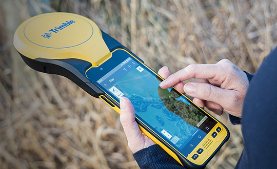
Trimble has announced a new high-performance data collector for its Mapping and Geographic Information Systems (GIS) portfolio — the Trimble TDC650 handheld. Built for GIS data collection, inspection and asset management activities, the TDC650 provides users a rugged solution with scalable high-accuracy GNSS positioning for professional field workflows.
The TDC650 is fully integrated with today’s demanding GIS data environment, powered by the Trimble Software Development Kit (SDK) that enables precision GNSS positioning for apps such as Esri ArcGIS Field Maps and Trimble TerraFlex software. The TDC650 is also a scalable solution that allows customers to choose their desired accuracy down to the centimeter-level to meet needs and budget requirements.
“This is an ideal tool for customers tasked with modernizing critical utilities including electric, gas and telecommunications networks,” said Gareth Gibson, marketing director, Trimble Mapping and GIS. “The precision, quality and data integration workflows needed to map the physical world to a digital one in these projects requires a modern data-collection platform like the TDC650.”
City, state and local governments and utilities will benefit from this solution, which is part of the larger Trimble Public Sector ecosystem that includes Cityworks software for stormwater inspections and Trimble Unity for monitoring municipal water pressure and hazards. As GIS data continues to grow more complex, Trimble helps simplify, visualize and make sense of the data so customers can make better decisions in managing their communities’ assets.
A bill moving through the U.S. Congress would impose a five-year ban on United States government purchases of drones manufactured or assembled in China, reports The Associated Press. The measure reflects bipartisan concerns that the unmanned aerial vehicles (UAVs) made in China could facilitate Chinese spying on critical infrastructure.
Major commercial and consumer UAV-maker company DJI is based in Shenzhen, China. Many of its small, low-altitude drones are employed by local and regional government users in law enforcement, emergency response and surveying. The ban could affect police departments that rely on federal funds for equipment. In 2020, the Department of Homeland Security halted such grants for Chinese-made drones.
Chinese-made components, including GNSS receivers and inertial sensors, are not addressed in the bill, and the Pentagon has acknowledged that many components for non-Chinese-company drones are made in China.
While the ban wouldn’t go into effect until 2023, many federal agencies have already imposed temporary restrictions on the use of Chinese drones. The Interior Department had flown more than 11,000 drone missions before January, when the agency temporarily grounded its fleet of more than 500 DJI drones over cybersecurity concerns, according to The Hill. The Hill cites a May 6 Pentagon report. The report found no malicious code in the software for DJI’s Government Edition drones.
An analysis by Booz Allen Hamilton released in June 2020 found no evidence that DJI drones have shared sensitive information with the company or the Chinese Communist Party.
In August 2020, the Defense Department issued approval to drones from five companies:
Skydio’s X2-D. Skydio is based in Redwood City, California.
Parrot’s Anafi USA. While Parrot is based in Paris, France, the ANAFI USA drone is manufactured in the United States for U.S. customers.
Teledyne FLIR’s Flir M440 Ion. The drone was originally made by Altavian in Florida, which was acquired by FLIR in December 2020, which was subsequently acquired by Teledyne Technologies in January. Teledyne FLIR is headquartered in Wilsonville, Oregon.
Teal Drones’ Golden Eagle. Teal Drones is based in Salt Lake City, Utah.
Vantage Robotics’ Vesper. Vantage is based in San Leandro, California.
Can GPS support a greener, more sustainable planet? The answer is an emphatic “yes,” and it is already doing so today.
GPS has become a fundamental technology across nearly every sector of the U.S. economy, including agriculture, transportation, construction and municipal services. In each of these industries, the use of GPS has produced substantial environmental benefits, such as lowered carbon emissions, increased water efficiency, decreased use of environmentally sensitive inputs, and reduced waste.
Agriculture
Let’s take a closer look at how GPS is protecting our nation’s critical environmental resources. We begin with agriculture where it is estimated that the absence of GPS during peak planting season could result in an economic loss of more than $15 billion, according to a National Institute of Standards and Technology report.
During the past two decades, GPS has transformed American farming, enabling increased crop yields, cost efficiencies, and environmental sustainability through the precise application of seed, water, fertilizers and pesticides and the efficient use of fuel. In sum, precision agriculture lets farmers do more with less wasted seed, less fertilizer, less fuel, less pesticide, and more crop yield.
GPS Innovation Alliance (GPSIA) founding member Deere & Company reports that precision agriculture technologies can have a huge impact on resource efficiency and sustainability. By 2030, GPS-enabled precision agriculture implemented globally could save 180 billion cubic meters of water, says the World Economic Forum.
Similarly, according to the U.S. Department of Agriculture’s Natural Resources Conservation Service (NRCS), if “[GPS] guidance systems were used on 10 percent of the planted acres in the United States, fuel use would be cut by 16 million gallons, herbicide use by two million quarts, and insecticide use by four million pounds per year.” For a single Midwest row crop farmer, with 6,500 acres using precision agriculture techniques, Deere & Company estimates that more than 1,600 gallons of fuel could be saved, and more than 400,000 kg CO2 equivalent emissions could be avoided, over the course of a production cycle — the equivalent of nearly a million (992,000) passenger car miles driven per year.
Infographic: GPS Innovation Alliance
Construction
Construction is another industry that has been revolutionized by GPS. Today, high-precision GPS is used to support the building of roads, bridges and other significant infrastructure projects. In 2019, testimony before the U.S. House Small Business Committee, an executive of GPSIA founding member Trimble described several examples of how digital construction technologies, including GPS, can more efficiently plan and execute complex construction projects.
In one such example from Southern California, the improvements “reduced the wetland impact by 58 acres; reduced the impact to sensitive species; reduced landslide risk; reduced residential displacement; and minimized the impact on existing utilities (resulting in few utility relocations to undisturbed areas).”
GPS receivers are also embedded in many bulldozers, excavators and graders, resulting in reduced waste and lower fuel consumption. They can reduce greenhouse gas emissions, with an estimate from Trimble suggesting that the use of machine control technologies can cut more than one billion pounds of CO2 usage per year.
NextGen Air
GPS is also at the heart of the Next Generation Air Transportation System, or NextGen, of the Federal Aviation Administration (FAA). Capt. Sully Sullenberger, during a 2020 GPSIA-sponsored event, described air traffic control modernization as depending “massively on the ubiquity and reliability of GPS.”
Along with the safety benefits of knowing the precise location of an aircraft, GPS enables optimized flight paths that the FAA says can reduce “flying time, fuel use, and aircraft exhaust emissions.” These efficiencies have already resulted in $1.2 billion in fuel savings, according to the FAA.
During a 2010 test flight over Puget Sound, Washington, Alaska Airlines found that the use of GPS-aided flight procedures reduced emissions by 35% compared to a conventional landing. Other airlines have also quantified these benefits, finding substantial savings in fuel consumption simply by cutting a single minute from each flight.
Weather and Disaster Forecasts
No one can argue the fact that weather events like hurricanes, floods and droughts have a huge impact on the environment and public safety. According to the National Oceanographic and Atmospheric Administration (NOAA), in 2020 such events cost $95 billion in damages. You may not realize, however, that NOAA uses GPS signals to support three-dimensional meteorology, space weather and geophysical applications throughout the United States.
Even NOAA’s Geostationary Operational Environmental Satellites (GOES) use GPS signals to enhance their ability to provide the data we all receive in each morning’s TV weather forecast, improving weather predictions and our own storm situational awareness. GPSIA member Lockheed Martin manufactures both the GOES-R series of weather satellites and the U.S. Space Force’s more powerful, next-generation GPS III satellites that are now being launched to modernize the GPS constellation.
Municipalities
Lastly, we examine the environmental benefits for municipalities that use GPS for key government services, including the real-time tracking of garbage trucks, snowplows and buses. Throughout the country, towns and cities have seen substantial savings in dollars, fuel and time from implementing GPS-enabled technologies.
In Niles, Illinois, for example, the Department of Public Works partnered with GPSIA founding member Garmin to optimize the routing of snowplows. Using GPS technology, drivers reduced the use of salt by as much as 40%, resulting in more than 700 tons saved. In 2020, in recognition of its innovative use of GPS, the department received the Management Innovation Award from the American Public Works Association. Similarly, GPSIA member CalAmp found that GPS use for vehicle tracking can result in fuel savings of $90 per vehicle per month.
Ensuring GPS
Ensuring these environmental benefits can continue to be realized requires that the spectrum used by GPS be protected from harmful interference. It will also depend on continued funding by Congress to modernize the GPS constellation and ground control. Additionally, as Congress considers a major infrastructure bill, including funding for states and localities, we would encourage projects to make use of GPS and other innovative technologies that can drive down costs, reduce carbon emissions, and eliminate waste — including advanced digital-construction management systems that use GPS data to reduce project costs and speed project delivery.
GPS has changed our everyday lives for the better, and as our dependence on this technology continues to grow, so will its impact on environmental sustainability efforts.
Aerial imagery company Nearmap is partnering with Geographic Technologies Group (GTG), which helps local government agencies throughout the United States and Canada with geographic information systems (GIS).
GTG offers local governments with GIS services including strategic planning, consulting, comprehensive data services, mapping services, software development, training and on-call support. GTG also provides ongoing GIS maintenance for villages, towns, cities, counties, multi-regional agencies, public works and public utilities, water districts, and Native American and Alaskan Tribes.
“Our range of high-resolution aerial content — from vertical to oblique, 3D and AI [artificial intelligence] — integrates easily with GTG’s applications and acts as a valuable component to the strategic planning services offered by GTG,” said Karl Terrey, director, Global Alliances at Nearmap. “Our imagery is refreshed multiple times per year and, when combined with GTG’s technology, allows cities, towns, counties and state governments to make decisions based on conditions in their communities in near real time, at a fraction of the cost.”
Nearmap’s 3D imagery provides local governments with the ability to quickly export custom areas for use in platforms such as Esri, Bentley Systems and Autodesk. Nearmap AI enables governments to instantly identify attributes about properties required for the appraisal process. Nearmap AI Packs enable users to determine the type of access made visible in MapBrowser for items such as impervious surfaces, vegetation and solar panels at citywide scale.
Nearmap’s library of aerial imagery provides some of the most accurate imagery available with updates occurring up to three times a year throughout more than 430 markets in North America, including 700 urban and regional areas accounting for more than 70 percent of the United States population.
“Our goal has always been to break through boundaries, solve problems, and introduce a new kind of decision support for our clients,” said James Kelt, vice president of corporate software at GTG. “We began using Nearmap’s aerial imagery a few years ago because we recognized it as a way to differentiate ourselves and push the envelope. Our clients love the imagery and the more we worked with Nearmap, the more it made sense to find a way to partner so we could provide this added value to all of our customers.”
Avineon, Inc., a global provider of information technology, geospatial, and engineering support services, will distribute discount coupons for its new Metrics Extension to ArcGIS for Server at the 2015 Esri User Conference. Ten customers who activate the permanent Metrics Extension license with the coupon code will receive it for free. All others using the coupon will receive a 50 percent discount off the $4,995 price if the permanent license is activated by Aug. 31, 2015.
Avineon will be handing out the discount coupons in booth #1015 at the Esri User Conference being held July 20-23 at the San Diego Convention Center in California.In addition, Avineon will be holding a drawing each day for a Windows Tablet. Anyone who registers at Booth #1015 will be entered into the drawing, no purchase required.
The Metrics Extension enhances the value and usability of GIS data in ArcGIS by creating a spatial data warehouse in which key business intelligence metrics can be created and stored for historical reporting. It computes and stores key metrics such as asset quantity, length, or area coverage for a specified period. Storing this data permits important historical trends to be documented and evaluated for potential performance improvements and cost savings.
“Metrics Extension gives ArcGIS users better visibility into their enterprise geodatabase by revealing trends in their global and regional data sets,” said Joel Campbell, Avineon vice president of commercial systems. “The return on investment for Metrics Extension will be fast.”
Avineon developed the Metrics Extension for ArcGIS users across all markets, especially in applications where the installation, operation, and decommissioning of assets need to be tracked over time. Asset changes and trends can be tracked by timeframe and by geographic area, such as neighborhood, zip code, and political district. The most common applications will be in energy and water/waste water utilities, telecommunications, and local/state/federal governments.
Avineon will also showcase its entire portfolio of geospatial services and solutions available to the Esri community. As a long time Esri business partner, Avineon specializes in data centric services and solutions serving a variety of industries.