Following is a guest editorial by GPS World’s contributing editor for Defense, Don Jewell.
Advanced low-frequency (LF) signals are back on the air in North America, with live testing of a wide-area precise-timing solution. Initial tests include a comprehensive pallet of signals, including eLoran, that are being evaluated for their ability to provide a robust, wide-area, wireless precise-timing alternative that can operate cooperatively with GPS, or during periods of GPS unavailability.
The high-power, virtually jam-proof and spoof-proof LF signals operate independently of GPS and GNSS, and provide a Universal Coordinated Time reference, critical to many aspects of U.S. national infrastructure, on the order of tens of nanoseconds.
Not only is this an independent timing backup, but the LF signals can also be used as pseudoranges mixed with GPS, or if enough transmitters are available, as a fully independent PNT network — in other words, a true backup PNT capability for safety-of-life navigation, for dispatching first responders, and for supporting critical national infrastructures.
This is an extremely positive development, especially in light of the LightSquared debacle and the now better-understood vulnerabilities of the very low-power GPS signals.
I hoped I would never have to type that word again, as a noun or a verb, but LightSquared did serve to point out a dire need and shortcoming in the U.S. PNT infrastructure. Fortunately, the proposed eLoran system appears to be on track to fill that need perfectly.
For the first 32 years that GPS signals were broadcast, Loran-C served as a timing backup and a less accurate but viable navigation alternative. In 2010, the current U.S. administration unplugged Loran-C, against the recommendations of the Department of Transportation’s Positioning and Navigation (PosNav) Committee, the Department of Homeland Security Geospatial Committee, the DOT Undersecretary for Policy, and the DHS Deputy Undersecretary for Preparedness and National Protection.
Long story short: non-technical people forced ill-advised technical decisions.
At that time, Loran-C was 80 percent of the way through a critical metamorphosis into a new digital version known as enhanced Loran or eLoran, with better, more reliable transmitters, smaller receivers, and a virtually jam-proof signal structure. Many likened eLoran to a strong ground-based GPS with coded signals for security.
Since then, the government has spent more money dismantling the legacy Loran-C infrastructure than it would have taken to complete the remaining 20 percent upgrade to eLoran.
Let’s hope the eLoran demonstrations continue successfully, and that a contract is forthcoming quickly before anyone forgets the LightSquared lessons learned — like we would ever let that happen.
In a few weeks, we will again observe the tragic anniversary of the 9/11 attacks on the United States. This will mark nearly a full decade since that terrible day that changed the lives of people around the world, forever. Many will remember. Many will mourn. Many will work to ensure that such an event never again threatens any nation. That is a good thing.
Few outside the position, navigation, and timing (PNT) community will also recall that the day before the 9/11 attacks, the U.S. government released a landmark document that described the vulnerabilities of services provided by GPS to disruption, whether by attack or inadvertent interference. The Department of Transportation Volpe Center’s GPS vulnerability assessment recommended that services utilizing GPS-provided PNT seek alternative sources of these services. What decisions and actions have the findings and recommendations of this report promoted? The answer is most disturbing.
The U.S. government has sealed the fate of Loran-C and kept the decision on an enhanced Loran system (eLoran) in limbo for more than 10 years. The government has spent hundreds of thousands (if not millions) of dollars studying the problem over and over again and either ignoring or classifying the results. The Department of Homeland Security (DHS), a direct outcome of the 9/11 attacks, has done nothing to address the need for a national backup other than study and re-study the problem and disregard the findings and warnings of world-class PNT experts.
On the positive side, a recent paper from the Federal Aviation Administration (FAA) attempts to address the problem by proposing to investigate alternative PNT (APNT). While the FAA does this under its Title 49 responsibility and authority to ensure the safety, security, and efficiency of our National Airspace System (NAS), and the alternatives it is looking at are certainly aviation-centric, it is admirable that somewhere in this government someone is finally moving forward to define and implement a real, operational PNT alternative to GNSS and its augmentations. [An abridgement of the FAA paper appeared in the July GPS World; the full paper is available here.]
I applaud the FAA’s actions and only hope that bureaucrats and bureaucratic processes don’t penalize it for its efforts.
But the question remains: When will a decision on the U.S. national PNT backup be made? The urgency of this issue can be highlighted by posing some simple questions about another current threat to the U.S. infrastructure and economy.
To what extent are GNSS-provided PNT services being used to identify the amount and movement of the oil in the Gulf of Mexico? What level of information exactness/integrity would be lost if GNSS-provided PNT services were not available?
To what extent are GNSS-provided PNT services being utilized by cleanup crews and other impact-mitigation services? How would the efficiency of the cleanup/mitigation activities be impeded if GNSS-provided services were not available?
Finally, what is the opportunity cost of not having a national PNT backup? Why has this decision been so hard to make? One would intuit that it has encountered political obstacles, not scientific ones. What are they, exactly?
While the FAA is doing what it must to ensure a safe, secure, and efficient national airspace, what about the rest of us? The boaters, the truckers, the farmers, the power transmission people, the telecom providers, the cell-phone users? The list goes on and on.
It has been nine years. Why is this so hard?
As we take time on September 11 to remember where we were when we heard the news, to mourn those lost, and to do, each in our our way, something to ensure that such a thing never happens again, we should also take time on September 10 to thank the folks at the Volpe Center for their important efforts. And we should try, each in our own way, to do something to ensure that the effects of a loss of GNSS-provided services will be once and for all properly mitigated.
The masked engineer harbors strong convictions, matched by a desire to hold onto a day job.
Yowza!!, an application designed for the latest GPS-enabled iPhone 3G and 3GS models and iPod Touch, brings relevant coupon offers to customers based on their location.
“Any time you insert a concept such as location into a marketing program, you end up with a far more compelling value proposition,” states Mike Wehrs, president of the Mobile Marketing Association.
Sales and discount offers via Yowza!! can be updated in real-time and targeted by region or store location. “The phone will deliver a list of stores within one mile that have offers on Yowza!!,” said August Trometer, co-founder of the recent startup. Users show the barcode and digital mobile coupon on their handset at checkout to redeem the discount on their purchase.
“We work directly with merchants; they provide us with their latitude and longitude, we get the GPS coordinates, do a database search with a proprietary algorithm,” said Trometer. “The phone constantly goes back and forth between our app, touching data from our database. When the person touches their location, it touches a new set of data in the database. The phone will work with them to keep delivering the closest store. There’s a lot of work on the database end of things.”
One drawback of the app is that it has to be turned on to work — it does not sit in the background, waiting to be activated by incoming offers. “Users have to give the application access to their GPS coordinates,” explained Trometer. “But the power of the device and all the applications it brings make it silly to turn off the location capability.”
Retailers that have signed with Yowza!! include Sears, McDonald’s, The Container Store, and more. Unlike traditional forms of couponing such as newspaper ads, Yowza!! offers can be updated in real time and targeted by region or store location.
Trometer expects to announce Yowza!! capability through other GPS-equipped phones: Blackberry Storm, Google’s Android-based phone, and the Palm Pre. “All three makers allow developer access to the GPS and this is very important, it’s crucial, obviously. They also have a high-res screen, which is a requirement for our scannable barcode that the user shows to the merchant.”
Referring to GPS handsets that lack a high-res screen, he claims “The other phone manufacturers really have an uphill battle right now.”
Whose GPS? The source of the GPS chip within Apple’s iPhone remains a mystery. “Even people who have done teardowns of the devices, the chips are completely blank,” says Trometer.
“There are so many possibilities, we’re just scratching the surface right now with what can be done,” Trometer said. “The mind reels with the things that can be done with that.”
>> SURVEY & CONSTRUCTION
Hemisphere, Juniper Jointly Offer DGPS Receiver for Demanding Environments
Juniper Systems and Hemisphere GPS offer the XF101 DGPS receiver for the Archer Field PC, designed to deliver sub-meter DGPS to location-based applications in demanding environments.
According to the companies, the Hemisphere GPS XF101 DGPS receiver provides: Crescent GPS technology for sub-meter accuracy; COAST technology to maintain accuracy during temporary loss of differential signal; optional external antenna for centimeter-level accuracy; low power consumption; modular connection for rapid field use; real-time or post-processed DGPS data collection; and multipath minimization.
The XF101 with the Archer is priced at less than $2,500. It fully supports mobile GIS applications such as ESRI ArcPad and OnPoz GNSS Driver.
>> AVIONICS
NovAtel Receiver for Next-Gen WAAS
NovAtel announced receipt of a contract from the U.S. Federal Aviation Administration (FAA) to develop the next generation Wide Area Augmentation System (WAAS) reference receiver, the GIII. Total contract value can go up to $9.7 million.
NovAtel has worked with the FAA WAAS program since 1995, providing and supporting two previous generations of reference receivers for the WAAS ground network. The technology refresh will add support for new L1C, L2C, and L5 signal capabilities, on a qualified RTCA DO-178B software and DO-254 hardware platform. The WAAS GIII receiver program is scheduled to be completed over the next three years, and will include growth provision for further signal capability such as Galileo. As many as 14 receivers will be produced in the GIII development and qualification program.
>> FLEET TRACKING
AT&T, Trimble Fleet Management
AT&T has broadened its fleet and mobile asset management portfolio with the latest version of Trimble’s GeoManager solution, which helps reduce fuel and maintenance costs by enabling operators to manage their vehicle assets more efficiently.
Trimble GeoManager enables transportation and field-service fleet operators to track their mobile workers and assets through software and GPS modems running on AT&T’s wireless network. GeoManager integrates GPS, wireless data communications, and a browser interface to help manage mobile workers, the mobile worker’s work, and the mobile worker’s assets.
AT&T and Trimble have jointly offered fleet-tracking solutions for several years. The GeoManager update features improved map and status, new landmark uploads, WLAN usage, schedule report enhancements, driver logs, and organizational hierarchy modifications.
>> TIMING
Timing Vulnerability Concern Grows
Industrial and enterprise users in telecommunications and utilities privately express concern over revelations from the April Government Accounting Office (GAO) report, “Global Positioning System: Significant Challenges in Sustaining and Upgrading Widely Used Capabilities.” The GPS signal is used for synchronizing almost all global computer networks belonging to the military, utilities, banks, telecomms, television companies, and many more.
Backup? What Backup? These same companies point to a continued lack of commitment on the part of the U.S. government to stable and reliable backup for GPS. As long ago as 2007, in comments before the Department of Transportation, wireless carrier Sprint Nextel stated: “Sprint Nextel Corporation respectfully requests that the U.S. government continue to operate and invest in the LORAN-C and eLORAN systems. Should the DOT and DHS decide to decommission the LORAN-C system, Sprint Nextel recommends that the agencies delay doing so until the eLORAN system is fully operational. Sprint Nextel and other communications providers use the frequency signals of the Global Positioning System, LORAN, and atomic clocks for multiple levels of redundancy and diversity in their networks. Therefore, Sprint Nextel urges the DOT and DHS to carefully weigh decisions which might impact LORAN’s availability to the nation’s voice and data communications networks.
“The loss of a primary reference source (PRS) can negatively impact a telecommunications network, and those impacts can vary from minor short-term noise impairments to long-term network-wide outages. Both traditional wireline services and newer wireless services require a precise frequency reference for basic service delivery . . . . The continental U.S. portion of the Sprint Nextel network requires a PRS at thousands of switch sites, interconnection sites
, and cell tower sites to ensure reliable service delivery.”
Deadlock on Capitol Hill. Competing resolutions to either discontinue or adequately fund LORAN and eLORAN continue fencing in Congressional subcommittees in both chambers. Nothing has changed since Sprint commented two years ago — aside from a potential rise in the susceptibility of GPS to jamming, unintentional interference, and decreased availability.
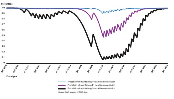
GAO REPORT, FIGURE 5. Probability of maintaining constellation of at least 18, 21, and 24 GPS satellites based on reliability data as of March 2009 and a two-year GPS III launch delay.
>> TIMING
Telecom Clock from EndRun
EndRun Technologies announced a Telecom Clock Option for its Meridian Precision GPS Timebase, which provides accurate and stable GPS-synchronized outputs for military communications, aerospace, broadcast, engineering and calibration laboratories, telecommunications, and more.
The option was designed as a plug-and-play module that can supply any combination of E1, T1, J1 and/or composite clock outputs. An alarm output is also available and single-satellite mode (SSM) is supported. The Telecom Clock Option can be installed in EndRun’s GPS or CDMA-based Meridian and Tycho product lines.