Honeywell has launched Kestrel, a compact navigation solution designed to help uncrewed aerial systems (UAS) operate reliably in contested environments where GPS signals may be degraded, jammed or spoofed.
Built to support the growing demand for smaller, more affordable and highly efficient platforms, Kestrel combines Honeywell Aerospace’s HG3900 MEMS inertial measurement unit with an M-code receiver and a multi-GNSS receiver. The platform is intended to meet the specific needs of Group 2 and 3 collaborative combat aircraft and loitering munitions platforms. It is also suitable for crewed aircraft where size, weight, power and cost are important considerations.
“Kestrel reflects the evolving needs of today’s uncrewed operations, where operators are looking for resilient navigation technology that is smaller, lighter and more cost-effective,” said Matt Picchetti, vice president and general manager of Navigation & Sensors at Honeywell Aerospace. “This system helps operators maintain mission objectives in environments where legacy GPS systems are lagging behind.”
Kestrel is an Embedded GNSS/INS (EGI) system for global defense and commercial operators in need of advanced inertial navigation technology with secure positioning capabilities in a smaller footprint. The system is 40 percent smaller and lighter than similar navigation products while delivering up to an 80 percent improvement in navigation accuracy for uncrewed platforms. It also reduces costs by as much as 50 percent, helping operators efficiently scale deployment across high-volume drone operations. Kestrel’s resiliency reduces UAS attrition by 60 percent, while more than doubling the capacity for mission distances.
The ability to operate without assured GNSS access is a distinct advantage for any military aircraft operating in contested or GNSS-denied environments because it provides continuous, self-contained position, velocity and attitude estimates independent of external signals.
Kestrel is designed to support a broad range of defense and commercial applications and will be available in configurations that support international and non-ITAR deployments.
Honeywell pioneered EGI technology and has produced more than 60,000 units since the mid-1990s to meet customers’ most challenging navigation, pointing, stabilization and flight-control applications.
The U.S. Air Force has opened market research for a GPS Increment 2 GNSS M-code receiver for the Joint Air-to-Surface Standoff Missile (JASSM) program.
The Air Force’s Materiel Command Lifecycle Management Center at Eglin Air Force Base published a Request for Information on March 17 to identify qualified vendors capable of developing and producing the receiver.
Key requirements include:
demonstrating a point-of-departure design at or above Technology Readiness Level/Manufacturing Readiness Level 5 applicable to U.S. Department of Defense tactical missiles
identifying existing programs leveraged
providing current TRL and MRL status
presenting a funded development plan to achieve required maturity.
Respondents must also
describe their technical approach for the GPS receiver
identify the status of Increment 2 M-code Application Specific Integrated Circuit certification with the GPS Directorate Security Team
demonstrate an active production line delivering DoD M-code receivers where possible
provide a notional low-risk development and integration schedule from contract award.
The government is using the market research phase to assess vendor capability before proceeding to formal solicitation. The opportunity is open to qualified commercial vendors without foreign participation. The government is seeking established manufacturers with demonstrated capability in DoD M-code receiver production.
Respondents must submit white paper responses of 10 pages or less by May 29. Administrative information including company credentials, facility security clearance, and executed Non-Disclosure Agreements must be submitted separately and do not count toward the 10-page limit.
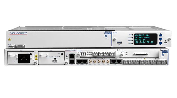
ADVA and Brandywine Communications have partnered to provide a defense-grade M-code device with advanced timing, the OSA 5422 grandmaster clock, for military applications. ADVA’s OSA 5422 meets key requirements of military networks by providing advanced positioning, navigation and timing (PNT) capabilities and improved resilience.
ADVA’s OSA 5422 grandmaster clock is integrated with a highly reliable M-code receiver, which meets stringent frequency and phase synchronization needs. The device is equipped with multi-band, multi-constellation GNSS receivers for when M-code is not available. OSA 5422 also has long holdover and precision time protocol backup, which enables it to maintain accurate timing even in the event of M-code disruption.
The OSA 5422 supports legacy interfaces such as BITS and IRIG and features eight field-upgradable 10G bit/s ports and 1G bit/s interfaces. The device is suitable for most demanding military edge applications.
A roundup of recent products in the GNSS and inertial positioning industry from the August 2022 issue of GPS World magazine.
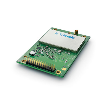
OEM
Receiver Module
Designed for autonomous applications
Photo: Trimble
The Trimble BD9250 dual-frequency receiver module supports Trimble RTX correction services and is designed to deliver high-accuracy positioning for high-volume, autonomous-ready applications in agriculture, construction, robotics and logistics. The compact receiver has an industry-standard form factor and pinout, allowing for easy system integration and configuration. Equipped with Trimble’s advanced ProPoint positioning engine, the BD9250 delivers robust and accurate positioning. It is compatible with Trimble RTX correction services or real-time kinematic (RTK) and supports GPS, Galileo, GLONASS and BeiDou as well as QZSS and NavIC. Support for the Indian NavIC S-Band signal is also available.
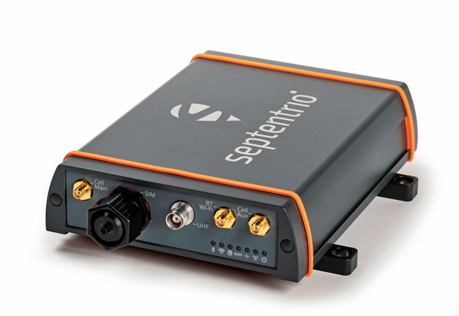
The AsteRx-U3 ruggedized GNSS receiver is the successor to the AsteRx-U for construction, mining and other machine control applications. It combines a triple-band precise positioning GNSS core with extended wireless communication features including Wi-Fi, UHF and 4G LTE, making it easy to fit it into any control system. The AsteRx-U3 offers low latency of under 10 msec with a high data rate, which allows machines to work rapidly and accurately. An IP68-rated housing, with fixing brackets and robust M12 connectors, enables quick installation.
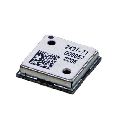
The M20071 integrated GNSS receiver module, measuring 9 x 9 x 1.8 mm, incorporates the MediaTek AG3335MN flash chip. The receiver tracks four GNSS constellations concurrently (GPS + Galileo + GLONASS + BeiDou). The 1.8-volt system power supply provides outstanding low power consumption. Its multipath algorithms improve position accuracy in inner-city environments. The onboard low noise amplifier provides good performance in weak signal environments such as wearable devices.
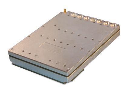
The Strategic Anti-jam Beamforming Receiver – M-Code (SABR-M) enables precise geolocation and strike capabilities in highly contested battlespaces. It integrates receiver technology with advanced antenna electronics in a small, hardened package designed to meet challenging performance requirements. It delivers accurate position, velocity, altitude and timing data, as well as strong protection against GPS signal jamming and spoofing. At 4.5 x 6 x 1 inches, the SABR-M meets size, weight, power, cost (SWaP-C) and thermal requirements for space-constrained military applications. It uses advanced beamforming technology to improve GPS signal reception and counter threat signals.
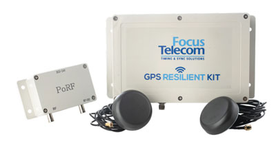
The GPS Resilient Kit (GRK) is a cybersecurity device that comes with two antennas for monitoring and protecting time-critical infrastructures. It can be integrated with any GNSS receiver, either as a retrofit or in greenfield deployment. The GRK features a proprietary interference filtering algorithm for maximum protection, up to 40-dB attenuation of jamming signals with the premium option. It requires minimal power consumption while providing cloud-based monitoring with real-time reporting of jamming attacks. It protects GPS L1 (C/A code) with a latency of 100 ns ±15 ns (fixed).
GBaaS enables providers to combat PNT cyberattacks
Photo: ADVA
GNSS-backup-as-a-service (GBaaS) enables service providers to help operators safeguard services that rely on positioning, navigation and timing (PNT). In-network timing based on network time protocols (NTP) and precision time protocols (PTP) are also increasingly vulnerable to cyber threats. GBaas is based on ADVA’s aPNT+ platform, which leverages a suite of technologies, including multi-band GNSS receivers and management software based on artificial intelligence and machine-learning. Service providers can offer ADVA’s aPNT+ protection as a subscription-based service as part of their service-level agreements.
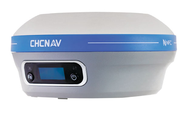
The i73+ pocket-sized receiver is a powerful and versatile receiver with an integrated UHF modem that delivers survey-grade accuracy in all jobsite configurations. It has 624 GNSS channels and the latest iStar technology and can be operated as either a base station or a rover. The i73+ is a highly productive NTRIP rover when used with a handheld controller or tablet and connected to a GNSS RTK network via CHCNAV LandStar field software. The receiver takes advantage of GPS, GLONASS, Galileo and BeiDou, in particular the latest BeiDou 3 signal, to provide robust data quality at all times.
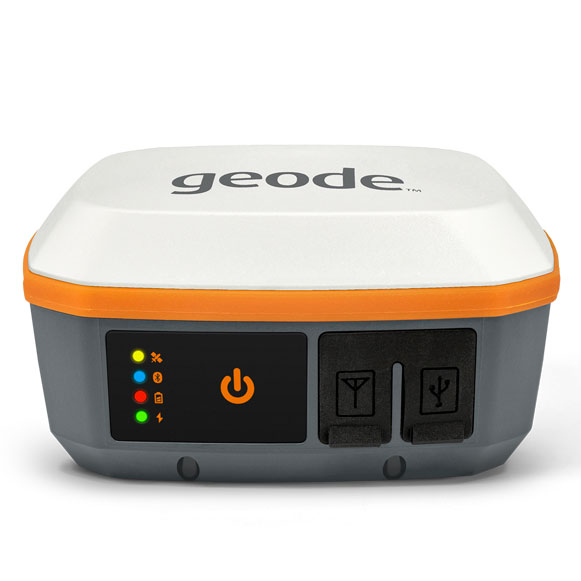
The Geode GNS3 GNSS receiver allows users to collect real-time GNSS data with sub-meter, sub-foot and decimeter accuracy options. With a scalable accuracy platform, users can purchase what they need now, while having the option to increase accuracy in the future. It offers sub-meter accuracy with a single-frequency antenna, while its multi-frequency antenna supports all constellations on L1, L2 and L5. Atlas L-band corrections allow the Geode to be used in water utility locating, agriculture and irrigation mapping, as well as mapping projects in remote locations where other correction services are not available. The Geode GNS3 can be used with Windows, Android, iPhone and iPad devices.
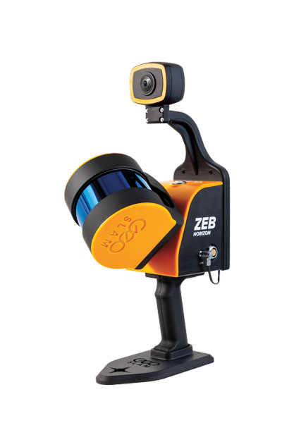
Improved colorization to contextualize point clouds
Photo: GeoSLAM
The ZEB Vision is a camera accessory for the ZEB Horizon system that can be used to capture 360° panoramic photography in 4K definition for point cloud colorization. Data is captured as the user walks through the area of interest. The ZEB Vision uses GeoSLAM’s SLAM algorithm to automatically and accurately position panoramic photos on a point cloud for an interactive viewing experience. The ZEB Vision attaches easily to the ZEB Horizon. The 4K resolution increases feature definition of objects within the point cloud, allowing for a new perspective on data by navigating within a virtual representation of an environment. This means industries such as architecture, construction and facilities can add real-world context to point clouds for the creation of CAD/BIM models.
The Leica Chiroptera-5 is a high-performance airborne bathymetric lidar sensor for coastal and inland water surveys. It combines airborne bathymetric and topographic lidar sensors with a four-band camera to collect seamless data from the seabed to land. Compared to previous models, the Chiroptera-5 provides 40% higher point density, a 20% increase in water-depth penetration, and improved topographic sensitivity for generating more detailed hydrographic maps. Its high-resolution lidar data supports nautical charting, coastal infrastructure planning, environmental monitoring and landslide and erosion risk assessments.
The Clirio application combines mobile lidar 3D scanning with smart remote collaboration tools to offer teams an end-to-end 3D solution to capture, organize, share and problem-solve. This is all based on real-time field observations and data, whether team members are on site or a continent away. Clirio is a set of mobile, web and VR/AR apps for instantly capturing, sharing, reviewing and resolving worksite field observations. At a field site, Clirio users collect notes, photos and 3D scans (using the laser scanner built into a new iPad Pro or iPhone Pro). These field observations are automatically geo-referenced within the map-based workspace and synced to a secure cloud workspace. An intuitive interface allows colleagues, managers, partners, or stakeholders to sort, review, compare, and act on field observations.
The Visual Parking System (VPS) by Bird is designed to keep track of scooter parking in a scalable, efficient and vandalism-immune way that requires zero infrastructure within a community. Powered by Google’s ARCore Geospatial API, VPS enables scooter parking with pinpoint accuracy. When parking a scooter, riders will be prompted to take a quick scan of their surroundings. The system seamlessly compares a rider’s images against Google’s data and Street View images in real time to produce the best available parking solution. Stationary objects such as buildings and signs are used as reference points, while more dynamic objects such as people and vehicles are disregarded. The near-instantaneous process results in a precise, centimeter-level geolocation that enables Bird VPS to detect and prevent improper parking with extreme accuracy, helping ensure Bird vehicles are only left in approved areas.
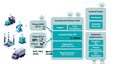
Supports Industry 4.0 with real-time visibility of assets
Photo: Pozyx
The Pozyx Platform is an asset tracking and identification solution for seamless indoor and outdoor tracking, following packages or other assets from trucks to their destination. It is based on the omlox hub, an open standard for real-time location systems that combines GPS data with data from ultra-wideband, 5G, radio-frequency identification, Wi-Fi and Bluetooth. The Pozyx Platform offers a seamless indoor/outdoor transition with zoom-in from a worldwide map to a detailed indoor map, showing highly accurate locations up to 10 cm. It is designed for smart manufacturing, providing a supply-chain solution that supports Industry 4.0. It tracks and identifies any asset, providing real-time data to facilitate warehouse and inventory control, keep track of critical tools, and slash lost asset costs.
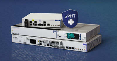
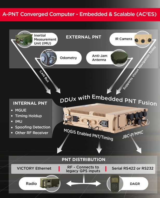
Leonardo DRS’ A-PNT Converged Computer – Embedded & Scalable (AC²ES) adds capabilities to its widely used DDUx. Photo: Leonardo DRS
To help counter attacks that degrade GNSS capability on combat vehicles, Leonardo DRS developed a modified data-distribution unit computer, the DDUx II, with an embedded assured positioning, navigation and timing (APNT) capability the company calls Assured Positioning, Navigation and Timing Converged Computer Embedded & Scalable (AC²ES). It augments standard military GPS PNT sources with technologies such as anti-jam, anti-spoof, M-code receivers, additional RF sources, vehicle infrared (IR) sensor vision navigation, wheel rotation and inertial measurement units (IMUs). It also offers a choice of multiple timing holdup modules that increase accuracy proportionately with cost.
The DDUx II and military variants, fielded by the U.S. Army and Marine Corps, allow for integration of APNT functionality with the Battle Management System (BMS). It can provide APNT distribution to all other devices needing PNT within the vehicle without adding to its size, weight and power (SWAP).
Following a five-year development program, Leonardo DRS launched the AC²ES in September 2021 as a commercial option while continuing discussions with the U.S. Army and Marine Corps, which have not yet adopted it. “We have tested it,” said Mike Stucki, business development manager for the company’s land electronics division. “We have gone to Army jamming and testing events. We have performance and results. However, it has not been officially tested under the Army or Marines programs, with which we are moving forward this year.”
Leonardo DRS wants to offer the armed services the additional components they need to achieve APNT “and not require them to buy anything they don’t need or want,” Stucki said. Those additional components include multiple GNSS receivers for timing and a low-end internal IMU to provide continuous navigation in case GNSS is disrupted. All these components fit directly into the existing DRS hardware. Under the Mounted Family of Computer Systems (MFoCS) program alone, the Army has fielded more than 100,000 DDUx units. Some vehicles already have high-end INS, wheel encoders, and other sensors, and MFoCS can ingest their data.
Navigating with Infrared
For vision navigation, Leonardo DRS uses software developed by its partner Leidos that ingests data from existing hardware on the vehicles, many of which already have IR cameras. In a GNSS-denied environment, this enables the system to navigate by matching what the IR camera sees to an imagery database. Leidos’ software is based on work it began in 2011 with the DARPA All-Source Positioning and Navigation (ASPN) program.
“Leidos developed algorithms that use these other sensor inputs in the sensor-fusion engine to provide more accurate absolute positioning in a completely RF-denied environment,” said Kevin Betts, PNT director for Leidos. “We take the live images from the vehicle’s existing IR camera and match them to a satellite-derived model of the environment. When the images match, we have an absolute position update that we can provide to the navigation filter.”
MFoCS “is the heart that runs the Blue Force tracker system that the soldiers use,” said Bart Blanchard, director of advanced programs at Leonardo DRS. “We’ve added the APNT components inside that box. They’re leveraging the hardware that they already own. It’s a very cost-effective solution.”
Flexible, resilient military PNT designed for every military environment
Orolia, through its Orolia Defense & Security business, has announced the availability of M-code military GPS receivers in its resilient PNT products and solutions, including M-code-enabled mobile mission timing and synchronization platforms.
M-code capabilities further enhance Orolia’s Versa mobile PNT platform for rugged, small SWaP-C requirements and Orolia’s flagship SecureSync resilient time and frequency reference solution — the first Defense Information Systems Agency (DISA) approved time server.
M-code is a military signal used in the L1 and L2 GPS bands and is required by congressional mandate for U.S. Department of Defense (DoD) military operations. It is designed to enhance positioning, navigation and timing (PNT) capabilities and improved resistance to existing and emerging GPS threats, such as jamming and spoofing.
M-code offers several operational benefits, including a higher power signal with improved resistance to jamming and interference; advanced security features to prevent unauthorized access or exploitation; and improved message formats and signal modulation techniques for faster and more accurate performance.
“As threats against GPS increase, military forces will need M-code capabilities on mobile PNT systems to ensure continuous operations wherever they go,” said Hironori Sasaki, president of Orolia Defense & Security. “Orolia is proud to continue to support Department of Defense initiatives to ensure that warfighters have the most secure, reliable and accurate positioning, timing and synchronization solutions in any environment.”
From resilient PNT solutions to GPS/GNSS simulation, interference detection and mitigation, Orolia provides end-to-end NAVWAR and resilient PNT solutions to protect, augment and strengthen military systems for GPS-denied environments.
In 2019, the U.S. Air Force certified the security architecture of Raytheon Intelligence & Space’s M-code modules and receivers as providers of secure and reliable access to modernized GPS. The resilient receivers are designed for high anti-jam performance.
Raytheon’s M-code application-specific integrated circuit (ASIC) chip is either integrated into a ground-based receiver card optimized for low dynamic applications, or used as an avionics/naval receiver card to support multiple end users.
“Our focus is on taking a comprehensive approach to resilient navigation,” explained Chad Pillsbury, director for Raytheon’s Secure Sensor Solutions. “We provide the complete family of PNT solutions. We start with the fundamental components, like the ASIC chip, and tailor our solution for the platform and mission requirements.”
Open Architecture. Raytheon successfully completed testing of the first M-code receiver onboard the U.S. Air Force’s B-2 bomber in 2017. “Since then, we’ve undergone a number of tests internally and with third-parties. Our M-code receivers have standard interfaces and open architecture protocols, enabling them to work with both U.S. and allied systems. By pairing our M-code receiver with our anti-jam electronics and antenna, our systems enable warfighters to combat the most advanced threats seen in the world today,” Pilsbury said.
The receiver is planned to be incorporated into many fighters, bombers and weapons systems across the U.S. Department of Defense. “We provide enhanced anti-jam, anti-spoof GPS capabilities, as well as alternate navigation and multi-constellation support that represent a significant improvement over the systems currently used by today’s warfighters,” Pillsbury said.
Meeting Advancing Threats. “The hardest part is meeting a changing threat target,” Pillsbury explained. “The fact is the threat is advancing at a rapid rate. Because of that, challenges are constantly evolving.
“That means we had to design solutions that were simultaneously robust and secure, but also flexible and open so we can continually upgrade them. That’s not an easy thing to do.
“But, by taking a comprehensive approach that looked at the whole problem rather than just part of it, we’ve developed systems that address these challenges and have the flexibility to address future challenges.”
Raytheon’s M-code products are now available to the U.S. military and its allies in accordance with International Traffic in Arms Regulations and the U.S. State Department.
Collins Aerospace announced that its miniature PLGR engine – M-code (MPE-M) receiver has received approval from the GPS Directorate. Collins Aerospace’s Mike Shepherd talks more about the approval at Xponential 2019, which took place April 29-May 2 in Chicago.