Tag: machine learning

  • L5-only receiver designed for mobile phones

    L5-only receiver designed for mobile phones

    Greg Turetsky, oneNav Inc.
    Greg Turetsky, oneNav Inc.

    GNSS receivers first reached the commercial domain in the early 1980s. They were bigger than your average carry-on suitcase, weighed more, and consumed so much power that they needed to be plugged into an outlet. But technology advanced quickly, and by the mid-1980s commercial GNSS receivers were appearing in survey and marine markets.

    Generation 1. The first generation of truly mobile receivers, in the late 1990s, used only L1 C/A code and were typically found in rugged handhelds for outdoor enthusiasts. The receivers began appearing in mobile phones in the late 1990s.

    Gen 2. The second generation added GLONASS. These receivers had to have wider bandwidths on the order of 20-30 MHz to support the GLONASS FDMA signals at a slightly offset frequency from GPS L1.

    Gen 3. These receivers added support for Galileo. They started appearing in mainstream cellphones in about 2014. These phones still retained a single frequency front end in the L1 band, but had separate digital processing chains for all three satellite systems.

    Gen 4. This evolution added support for BeiDou and a single sideband L5 receiver where BeiDou, Galileo and GPS all have modernized signals. These receivers first appeared in phones in 2019 because of the added size, power and complexity of supporting a dual-band receiver. The front end is a burden on many phone models, especially with the rise of 5G. Plus, the L1 band has reliability issues with jamming and interference. The receivers only support a single sideband at L5 and are not utilizing the full capability of L5.


    Read the full white paper from oneNav.


    Why Consumer Devices Need L5

    Every GNSS user in every segment benefits from using the new, modernized signals in the L5 band. L5 signals are more accurate, reliable and available in sufficient numbers to support all user segments. Here are the major advantages of L5 over L1.

    • Signal structure (narrow correlation peak) accuracy
    • Wide bandwidth (multipath mitigation) accuracy
    • Pilot codes (longer coherent integration increasing SNR)
    • Multiple constellations and signals with common signal structure
    • Stronger signal transmission
    • Cleaner band with less interference
    • Signal availability

    The benefits of L5 are clear. That’s why many GNSS suppliers have started building L1/L5 solutions, and they are starting to appear in smartphones. It seems to be a natural progression to add an L5 receiver chain on top of an existing L1 solution and be able to reap the benefits. But bringing along the legacy L1 solution could actually have a negative impact on the overall solution.

    The oneNav L5 mobile GNSS system architecture. (Image: oneNav)
    The oneNav L5 mobile GNSS system architecture. (Image: oneNav)

    L5 Wideband Receiver

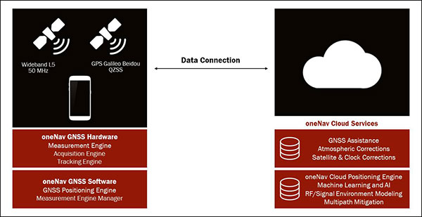
    We set out to build a fifth-generation GNSS receiver for mobile consumer products. Its single-frequency design only uses the modernized, wideband signals at L5. It has an acquisition engine sophisticated enough to acquire L5 signals directly and a navigation engine that uses artificial intelligence/machine learning (AI/ML) techniques to fully exploit all the signals in 50-MHz wideband at L5.

    Optimized engine. Building an acquisition engine for the L5 signal is a huge mathematical task. Since the codes are 10 times longer and have a 10 times faster chipping rate, it’s a 100 times more difficult search problem. The oneNav engine solves that problem with a customized array processor that has a GPU-like approach, maintaining TTFF.

    Single-frequency architecture. Pure L5 architecture eliminates the need for a second RF chain. The oneNav L5 engine uses common hardware for signals from all GNSS systems.

    Increased sensitivity. The L5 signal has a modernized signal structure that allows for increased sensitivity for both acquisition and tracking. With wideband architecture, all parts of the L5 signal can be combined for maximum performance and significantly more signal strength than L1.

    Improved time to fix. Dual-band receivers first get a fix on L1 and then begin the acquisition process on L5. By performing the L5 acquisition directly, we save time.

    Acquisition reliability. The L1 signal structures do not have the longer primary codes and the secondary codes like modernized signals on L5 that mitigate many of the reliability problems associated with cross correlation, jamming and spoofing.

    Improved tracking and measurement. Using the full bandwidth allows a more sophisticated channel estimation than a simple pseudorange measurement. With multiple signals contained within the L5 wideband signal, we gain advantages from channel diversity.

    AI/ML navigation engine. A cloud-connected navigation engine uses advanced AI/ML techniques to further improve navigation accuracy. Sophisticated ML techniques to predict if the received signal is line of sight and predict the measurement error caused by multipath. The cloud service allows reflected signals to be used correctly in the navigation solution rather than being excluded due to their multipath content. A sophisticated pattern-matching-based positioning algorithm combines the pseudorange measurements and the environment’s 3D building map model to enhance positioning accuracy in deep urban canyons.

    IP Core

    We designed the oneNav receiver as a licensable IP core rather than a discrete silicon solution. The complete solution includes all the firmware and an RF front-end reference design from antenna to A/D converter. This allows customers to determine how to best bring the oneNav advantages to their products.

    The IP core can be integrated into a larger ASIC such as a modem or an SOC. It could also be implemented as a discrete silicon solution. The RF could be combined into any of these solutions or implemented with other RF components in the system. The measurement and position engine firmware can be run on a dedicated CPU or shared in either the same or different CPUs for flexible system integration optimal for various applications. The IP core is both process independent and scalable. An integrated GNSS core means that GNSS performance can be maintained across multiple platforms and silicon generations, providing consistency of measurement and positioning performance needed to maintain system reliability and fusion.

    In my opinion, the Pure L5 wideband receiver can be considered a next generation — or fifth generation — of GNSS for mobile consumer products.


    Greg Turetzky is vice president, Product, for oneNav, and a member of GPS World’s Editorial Advisory Board. Read the full white paper from oneNav.

  • WHO Health Alert brings COVID-19 facts to billions via WhatsApp

    WHO Health Alert brings COVID-19 facts to billions via WhatsApp

    Image: wildpixel/iStock/Getty Images Plus/Getty Images
    Image: wildpixel/iStock/Getty Images Plus/Getty Images

    The World Health Organization (WHO) has launched a messaging service with partners WhatsApp and Facebook to keep people safe from coronavirus.

    The messaging service has the potential to reach 2 billion people and enables WHO to get information directly into the hands of the people that need it.

    From government leaders to health workers and family and friends, this messaging service will provide the latest news and information on coronavirus including details on symptoms and how people can protect themselves and others. It also provides the latest situation reports and numbers in real time to help government decision-makers protect the health of their populations.

    The service can be accessed through a link that opens a conversation on WhatsApp. Users can type “hi” to activate the conversation, prompting a menu of options that can help answer their questions about COVID-19.

    The WHO Health Alert was developed in collaboration with Praekelt.Org, using Turn machine learning technology.


    Check out more of GPS World‘s coverage of coronavirus here.

  • Apple applies for machine learning GNSS device

    Apple applies for machine learning GNSS device

    Logo: Apple

    Earlier this month, Apple applied to the Federal Communications Commission for to a license to install GPS testing equipment on its headquarters campus.

    This may be related to an application filed by Apple Inc. with the U.S. Patent Office in August 2019, which describes the company’s “Machine Learning Assisted Satellite Based Positioning.”

    From the patent application:

    MACHINE LEARNING ASSISTED SATELLITE BASED POSITIONING

    A device implementing a system for estimating device location includes at least one processor configured to receive an estimated position based on a positioning system comprising a Global Navigation Satellite System (GNSS) satellite, and receive a set of parameters associated with the estimated position.

    The processor is further configured to apply the set of parameters and the estimated position to a machine learning model, the machine learning model having been trained based at least on a position of a receiving device relative to the GNSS satellite.

    The processor is further configured to provide the estimated position and an output of the machine learning model to a Kalman filter, and provide an estimated device location based on an output of the Kalman filter.

    In 2015, Apple acquired the small enhanced-GPS company Coherent to aid the speed and accuracy of its devices’ location services. Presumably, Apple intends to incorporate its machine-learning positioning method into its navigation software.

  • ADVA tackles GNSS jamming and spoofing with AI solution

    ADVA has launched a centralized GNSS monitoring and assurance tool that uses artificial intelligence (AI) and machine learning (ML) for comprehensive predictive maintenance.

    The new customer-owned tool enables users to collect and analyze huge amounts of information from across the network to remotely identify issues and protect networks from GNSS vulnerabilities, including jamming and spoofing attacks.

    It also helps to identify GNSS obstruction issues, detect blind/poor spots that appear over time, and enable optimal antenna positioning.

    Built into ADVA’s Ensemble Controller network management suite with Sync Director, the solution enables customers to detect potential problems in advance, maintain the highest quality of network synchronization and significantly reduce opex. By complementing today’s limited distributed approach to GNSS assurance with a centralized-global system, it offers a major boost to critical infrastructure dependent on satellite-based timing.

    “What we’re offering is a way for network operators to see the bigger GNSS picture. Using AI and ML to analyze the entire synchronization network, our centralized GNSS monitoring and assurance solution will be key in the fight against GNSS cyber issues, such as jamming and spoofing attacks,” said Gil Biran, general manager, Oscilloquartz, ADVA.

    “This new technology provides the power to proactively tackle issues that jeopardize vital services,” Biran said. “Harnessing the capabilities of our synchronization devices to identify spoofing problems, it intelligently mines a wealth of data and gives network operators the precise info they need in a highly accessible way. By using long-term heat maps and enormous amounts of data from a wide range of GNSS receiver sources, our solution identifies patterns and preempts issues. It alerts maintenance teams to obstructions or jamming conditions so that countermeasures can be put in place well before services are affected.”

    As part of the network infrastructure, ADVA’s centralized GNSS assurance and monitoring solution enables a network-wide view of GNSS receiver health. Requiring no additional hardware or site visits, it remotely delivers detailed analysis, automatically detecting abnormal patterns with a patent-pending algorithm.

    Utilizing AI and ML, it alerts maintenance teams to potential GNSS service degradation and safeguards against spoofed signals. Network operators receive updates through a user-friendly GUI as well as regular reports tailored to individual criteria.

    As a component of ADVA’s comprehensive Ensemble Controller suite, the new technology makes synchronization monitoring and assurance an integral part of overall network management and control. For network operators, having a single system to track inventory simplifies operations and helps bolster network security.

    “GNSS is the fundamental source of network time, phase and frequency generation across so many of today’s industries. From IT to telecommunications, from energy to finance, the reliability of satellite-based timing is crucial and the cost of interference is huge. This latest launch is a key part of our ongoing mission to remove the risk of GNSS vulnerabilities,” said Nir Laufer, senior director, product line management, Oscilloquartz, ADVA.

    “The new solution joins our multi-band, multi-constellation GNSS receiver technology — which overcomes ionospheric delay variation — as well as our range of grandmaster clocks with network-based timing and outstanding holdover capabilities,” Laufer said. “Combined with our highly stable cesium clock technology, these create our ePRTC solutions for ultimate GNSS backup. With our comprehensive portfolio, all industry verticals are guaranteed accurate, cost-effective and highly resilient timing.”

  • Hexagon features smart autonomous solutions at CES 2020

    Hexagon features smart autonomous solutions at CES 2020

    Hexagon AB, a global leader in sensor, software and autonomous solutions, introduced its Smart Autonomous Mobility solutions portfolio today at CES 2020, bringing together all the necessary sensors, software and services to make autonomous driving possible.

    CES 2020, the massive annual consumer electronics show, is taking place Jan. 7-10 in Las Vegas. Hexagon’s Smart Autonomous Mobility solutions portfolio will be demonstrated in Hexagon’s pavilion CP-15.

    Hexagon said it is on a mission to enable all customers to accelerate and deploy a bold autonomous mobility vision — from research and development to advanced machine learning and simulation, to full integration and production into industry ecosystems.

    “Through our Smart Autonomous Mobility solutions portfolio, Hexagon is empowering an autonomous future that can transform ecosystems, protecting millions of lives and dramatically lowering carbon emissions,” said Ola Rollén, Hexagon president and CEO. “We are committed to providing complete technology solutions that enable our customers to build, test and put fully autonomous fleets to work safely.”

    The Smart Autonomous Mobility portfolio includes three solution sets: Enable, Accelerate and Deploy.

    Enable. Hexagon enables customers to fast-track R&D with hardware, software, and services to quickly enable autonomous driving systems across a variety of vehicle platforms and applications. From providing a turn-key automated driving research vehicle platform for field testing, integrating a customisable and assured positioning engine with reliable correction services, and offering baseline simulation tools and high-accuracy ground truth, Hexagon has already enabled thousands of customers worldwide with these technologies.

    Accelerate. Hexagon enables customers to create Smart Digital Realities — seamless workflows between real-world and simulated environments. To drive even 20% better than a human driver requires 11 billion miles of validation, which is equivalent to 500 years of non-stop driving in the real world with a fleet of 100 cars.

    Hexagon's Smart Solutions portfolio. (Image: Hexagon)
    Hexagon’s Smart Solutions portfolio. (Image: Hexagon)

    With machine learning, simulation and testing for entire system performance and engineering and integration services, and high-definition digital reality capture, visualization and on-demand feature extraction, Hexagon allows customers to optimise, verify and validate the necessary billions of miles of driving required to safely deploy autonomous vehicles to the road.

    Deploy. Hexagon allows customers to quickly scale from prototype and R&D phases to production for any autonomous application. The automotive-grade hardware solutions, autonomy software technologies, and functionally safe positioning solutions and services available in Hexagon’s Smart Autonomous Mobility portfolio are ready to deploy at scale for:

    • Mass production of passenger vehicles
    • Neighborhood electric vehicles (NEV)
    • Tractor trailers (class 8)
    • Off-road vehicles for mining, agriculture and defense
    • Robotics, aviation, marine and space travel.
  • Drones and imagery: Utilities turn to artificial intelligence

    How AI and machine learning algorithms redefine the way utility companies manage their infrastructure

    By Jaro Uljanovs, Lead AI Developer and Data Scientist, Sharper Shape

    Artificial intelligence (AI) boasts a wide range of potential applications, across nearly every industry imaginable — healthcare, automotive, retail, even fast food. But it’s the utility industry where AI and machine learning (ML) are beginning to demonstrate some of their most impactful effects on many aspects of the business. Power companies are increasingly leaning on AI to improve their electricity delivery and prevent potential wildfires, and AI is actually enhancing, rather than eliminating, human jobs.

    From data collection and analysis to their presentation of actionable insights, AI and ML algorithms are quickly redefining how utility companies manage their electric infrastructure.

    Consolidating and classifying data

    Utility companies oversee massive infrastructure networks, comprising poles, conductors, substations and transmission and distribution lines that span thousands of miles. The vegetation surrounding this key infrastructure must also be monitored, as it presents a danger of fire or outage.

    Taking a comprehensive snapshot of these assets means utilizing a variety of different sensors for network inspections. These sensors include lidar, color (RGB), hyperspectral and thermal imagery.

    This allows the system to capture everything — from vegetation proximity, to infrastructure assets, to individual components (such as insulators on poles) and their operational integrity, to hot spots indicating potential fire risks.

    That’s a lot of data to capture, catalog and process. And there are a lot of individual elements within that data — even in just one image — to pinpoint and classify, let alone do so accurately. Classifying billions of data points across all of those images is an impossibly time-consuming task to do manually.

    Photo: shaunl/E+/Getty Images
    Photo: shaunl/E+/Getty Images

    AI and ML tools can accomplish that same work — scanning thousands of images collected across thousands of miles of utility infrastructure — in seconds. Lidar point cloud segmentation can detect conductors (quite a difficult component-type to segment) with an accuracy of over 90%, while hyperspectral image segmentation can identify vegetation species with an accuracy of up to 99%.

    More than that, when paired with drone sensors, these algorithms can also improve the upfront collection of images and data. AI and ML tools help to adjust sensor positioning in real time, in the event a signal is lost or the drone veers slightly away from its inspection flight path.

    By helping to readjust the sensors’ bearings while in flight, AI not only ensures more accurate data collection, but also that the flight doesn’t need to be done again or prematurely ended because of faulty data collection, saving time and money. AI pinpoints any faults in the sensors or the drone’s flight path while in the air, recalibrating as needed and identifying individual elements within the data as it comes through the sensor’s video feed.

    Breaking down silos to create a holistic data approach

    Key to all of this is eliminating the silos that tend to naturally build up between different data segments. In the utility inspection space, asset management, vegetation management, different sensors and so on all produce their own disparate, walled-off sets of data.

    When data is kept siloed like this, it becomes unnecessarily difficult if not impossible for teams to derive companywide insights or conclusions from the information being collected. And what good is all that data if it can’t be used to check against itself and enhance other sets of data?

    The northwest fire line of the wildfire that devastated Santa Rosa, California, taken by satellite Oct. 10. (Satellite image ©2017 DigitalGlobe)
    The northwest fire line of the wildfire that devastated Santa Rosa, California, taken by satellite Oct. 10. (Satellite image ©2017 DigitalGlobe)

    Good data management can’t exist in a piecemeal approach. It needs to be holistic, and AI provides the impetus to make that happen. AI provides a central resource for pooling all these data sources together, making it easier to cross-analyze for potential problems — like wildfire-prone vegetation or damaged components. When these issues are collected in one system, it becomes much easier to identify faults and resolve them — and do so far faster than it would be to manually sift through countless images of poles or vegetation maps.

    And for all the stereotypical concerns about AI eliminating work for human beings, at utility companies AI actually enhances the role that people have to play in the network inspection process. Because the AI is what analyzes the data, it’s not something that is dependent on the potentially biased expertise of a professional human inspector, nor is it prone to fatigue and the anomalous results that can come from that. But at the same time, AI can’t do everything itself. It’s a tool for presenting clearer, more accurate and more actionable information for the people to then act on with their own judgment.

    There’s a lot of easy-to-make assumptions, both good and bad, about AI. But at the end of the day, what AI really means for the utility industry is a more efficient and effective tool for providing the right information about a power company’s infrastructure — its transmission and distributions lines, its poles, and its nearby vegetation — into the hands of its key decision makers.

  • Hexagon’s M.App Enterprise 2019 features 3D, machine learning

    Hexagon’s M.App Enterprise 2019 features 3D, machine learning

    LogoHexagon’s Geospatial Division launched M.App Enterprise 2019 at its user conference, HxGN LIVE 2019. The latest version of M.App Enterprise integrates capabilities from Hexagon’s Luciad Portfolio to enhance data visualizations, analytics and management.

    Designed to monitor assets, evaluate changes, and take action, M.App Enterprise is a privately-hosted platform that allows organizations to deploy Hexagon Smart M.Apps that dynamically address their location-based business problems.

    The new features in M.App Enterprise 2019 lay the foundation for users to experience a 5D smart digital reality, where data is connected seamlessly through the convergence of the physical world with the digital and intelligence is built into all processes.

    Screenshot: Hexagon Geospatial
    Screenshot: Hexagon Geospatial

    “The enhanced M.App Enterprise is now powered by our Luciad technology, which allows users to have the best of both worlds when it comes to data visualization and advanced analytics to communicate information effortlessly, and in real-time,” said Georg Hammerer, chief technology officer – applications for Hexagon’s Geospatial Division. “This unified geospatial enterprise platform can now further enable users and partners to create vertical solutions for their markets and industry segments.”

    The Luciad Portfolio integration will allow users to connect to, visualize and examine file-based vector and raster data from their Smart M.Apps in 3D. It also now renders terrain features realistically based on elevation data of the area.

    For covering large geographical areas with a higher resolution, M.App Enterprise 2019 allows users to connect to tiled elevation coverages offered by LuciadFusion.

    Furthermore, the addition of classification algorithms to the Spatial Workshop user interface enables M.App Enterprise to perform advanced remote sensing with machine learning.

  • Bentley Systems to acquire AIworx for machine learning, IoT

    Bentley Systems to acquire AIworx for machine learning, IoT

    Bentley Systems has entered an agreement to acquire Quebec City-based AIworx, provider of machine learning and internet of things (IoT) technologies and services.

    Bentley Systems is the leading global provider of software solutions to engineers, architects, geospatial professionals, constructors, and owner-operators for the design, construction, and operations of infrastructure.

    The addition of AIworx brings advancements in data collection and analysis to leverage infrastructure engineering digital twins, continuously updated with real-time contextual information, to optimize productivity, operations and maintenance, Bentley Systems said.

    Bentley Systems also announced the acquisition of ACE enterprise Slovakia, provider of innovative technology solutions to interface with enterprise resource planning (ERP), enterprise asset management (EAM), and geographical information systems. ACE enterprise has been a technology partner of Bentley Systems, and the ACE Enterprise Platform is used for the Bentley AssetWise connector that is certified for both SAP ERP and SAP HANA.

    AIworx machine learning and IoT technologies leverage digital twins’ analytics visibility for infrastructure asset performance. (Image: Bentley Systems)
    AIworx machine learning and IoT technologies leverage digital twins’ analytics visibility for infrastructure asset performance. (Image: Bentley Systems)

    “AIworx has been providing machine learning and IoT technologies and services to help organizations generate, understand, and act on data so they can make better business decisions,” said Andre Villemaire, co-founder and president of AIworx.

    “The biggest opportunities we’ve worked on have to do with improving infrastructure asset performance on an industrial scale, by way of the data from connected machines, instrumentation, sensors, and communications systems — and we’re excited to dedicate ourselves to that advancement,” Villemaire continued. “Now, by incorporating our tools into Bentley’s services for digital twins, we enable infrastructure operators to multiply the potential benefits of machine learning and IoT.”

    “Machine learning and IoT technologies have created the opportunity for profound improvements in productivity and efficiency of infrastructure,” said Francois Valois, vice president of portfolio development for Bentley Systems. “Our new colleagues from AIworx have already been delivering on this potential, and now, leveraging the analytics visibility, which Bentley’s digital twin cloud services uniquely provide, these advancements from going digital will accelerate exponentially.”

    Alexander Cimbalak, founder of ACE enterprise, said, “We have enjoyed our partnership with Bentley to provide enterprise connectors and are very excited to be part of Bentley and also now to enable Bentley’s digital twin cloud services to uniquely synchronize with infrastructure assets’ enterprise IT, OT, and ET data sources.”

    Alan Kiraly, senior vice president, asset performance for Bentley Systems, said, “ACE enterprise has consistently overcome IT interoperability challenges for us at Bentley. Now, as colleagues, this talented team will enable us to continue to expand the scope and breadth of information that can be accessed through AssetWise and digitally aligned within infrastructure digital twins.”

  • EagleView acquires OmniEarth machine learning for water management

    EagleView, provider of aerial imagery and data analytics for government and commercial industries, has acquired OmniEarth, developer of machine learning technologies and decision-making tools for the water resource management, energy and insurance markets.

    With the acquisition, EagleView gains OmniEarth’s machine learning capabilities, resulting in higher accuracy and precision of existing automated datasets.

    OmniEarth’s ability to extract data from geospatial imagery will enhance EagleView’s property reports and Pictometry imagery classification of land areas such as impervious surfaces or irrigated farmland. It will also better identify roof shape and condition, tree overhang, decks, pools and other notable property features, EagleView said.

    “We’re excited to welcome OmniEarth’s strong research-oriented management team, who will add to the innovative work that we’re doing at EagleView,” said EagleView President Rishi Daga. “This acquisition aligns perfectly with our mission of transforming industries by providing answers and saving time and money.”

    Water authorities and government agencies rely on the water resource management tools from OmniEarth to determine budgeting and water cost savings for individual parcels as well as identify the overuse or abuse of water. Like EagleView, OmniEarth also supports the insurance underwriting market through its property feature identification capabilities.

    “By gaining access to EagleView’s world-class Pictometry image library and product infrastructure, the OmniEarth team will be able to accelerate its development of advanced analytic solutions,” said Lars Dyrud, President and CEO of OmniEarth. “EagleView and OmniEarth have a shared goal of problem-solving and will be able to work together to achieve that vision.”

    The acquisition gives EagleView opportunities to offer additional property data solutions for roof rating, virtual inspection, vegetation mapping, impervious surface mapping, solar suitability, and insurance prefill.

    “OnmiEarth’s machine learning capabilities will create new opportunities for EagleView to use our imagery and property measurements to create a large prefill database,” said Frank Giuffrida, EagleView’s Executive Vice President of Engineering. “Additionally, marrying our high-resolution imagery and existing technologies with this machine learning system will help us accelerate our product development in existing markets as well as enter into new markets.”

    EagleView is enthusiastic that the OmniEarth technologies will accelerate time-to-market on new product enhancements and greatly improve customer workflow capabilities. These innovations align with EagleView’s goals of capturing more frequent, higher-resolution imagery that covers more physical area and scaling through automation.