Tag: Magellan

  • Magellan Debuts SmartGPS Apps for Apple and Android Mobile Devices

    Magellan SmartGPS App_iPhone
    screenshot: Magellan SmartGPS App

    Magellan has announced Magellan SmartGPS Apps for iOS and Android mobile devices.

    Following the recent announcement of Magellan’s SmartGPS device, the free Magellan SmartGPS Apps for iOS and Android devices are the next key elements in Magellan’s Smart Ecosystem, a cloud platform that integrates social media and navigation content directly onto a navigation map, the company said. The SmartGPS Apps automatically deliver continually updating reviews and tips for local businesses from social media including Yelp, Foursquare, and other partners to create current, local and personalized driving and pedestrian experiences.

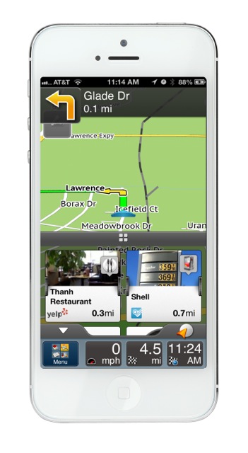
    The Magellan SmartGPS mobile apps display location-relevant information “squares” that graphically flip to show reviews, tips and offers from Yelp and Foursquare for nearby restaurants, stores and services. Users can then navigate to those locations directly from the SmartGPS App without needing to open an additional application or device. The cloud architecture enables new monetization of end users’ mobile search and navigation, and additional social media and content partners.

    “We architected the Smart Ecosystem to integrate with automotive infotainment and mobile network service platforms so users can enjoy a truly mobile, connected car experience now,” said Peggy Fong, president of MiTAC Digital Corporation. “SmartGPS mobile apps connect to the vehicle dash, allowing users to easily search social media and points-of-interest for destinations, and send the locations via Bluetooth or Wi-Fi to SmartGPS-enabled vehicle navigation systems.”

    Magellan’s free iOS and Android SmartGPS apps create a total-solution SmartGPS experience that is truly mobile. Magellan connects the smartphone to the vehicle dashboard, enabling location sync and sharing, hands-free operation and data connectivity. Users can pair their Magellan SmartGPS app with SmartGPS-enabled navigation systems. Using their SmartGPS App, SmartGPS enabled navigation system, or PC, users can search for a location, save the location in Magellan’s Smart Ecosystem cloud, and sync and share the location to any SmartGPS enabled device via Wi-Fi or Bluetooth.

    The free Magellan SmartGPS Apps will be available in North America this Spring, and in Europe this Summer, from iTunes and Google Play. Premium versions of both apps featuring spoken turn-by-turn navigation will also be available.

  • Magellan Launches Switch Series GPS Fitness Watches in Europe

    Magellan Launches Switch Series GPS Fitness Watches in Europe

    Magellan today announced that it has expanded the worldwide availability of the Magellan Switch Series of crossover GPS watches to Europe for athletes who run, bike, swim or participate in a variety of outdoor activities. The Magellan Switch and Switch Up watches are available this month from select retailers and through Magellan’s European distribution network.

    To support its European users, Magellan has also expanded its Magellan Active website with additional languages including French, Spanish, German, Italian and Dutch as well as English. Magellan Active makes it convenient for multisport athletes who record their performance data on Magellan’s Switch Series to easily upload and track data online with intuitive charts, maps and metrics, from a single location, Magellan said.

    “Magellan is continuing to further enrich the lives of multi-sport athletes worldwide with best-in-class fitness watches and innovative tools to help them take control of their active lifestyles,” said Clark Weber, Senior Director of Fitness Products for Magellan. “The Switch Series is rapidly gaining popularity with fitness enthusiasts, and we are pleased to work with our European distribution partners to make our GPS watches available to consumers throughout Europe.”

    Both Switch watches include features such as an Activity Pacer that shows runners if they are on target with their goal, and provides specific targets to attain the desired result. The Switch GPS watch, designed primarily for runners, includes nine customizable sport profiles, high-resolution display, eight hours of battery life, a high-sensitivity GPS receiver, 50-meter water resistance, and compatibility with ANT+ sensors. The Switch Up GPS watch has the same features as the Switch GPS watch but includes a barometric altimeter for precise elevation data, a thermometer to monitor and capture outside temperature, vibration alerts for notification in louder environments, and a quick-release mounting system to transition between sports.

    The Magellan Switch Series is available from Magellan’s European distribution partners serving UK, France, Germany, Turkey, Spain, Italy, Austria, Switzerland and Benelux.

    Developer API Program. Magellan also is making available its Magellan Active Developer API program. Third-party websites and applications can now access activity data from Magellan Active and import data into their websites once customer permission has been granted. A Magellan Active Web Widget can be embedded in any website for uploading activities and gives users the ability to upload activities and perform device software updates from within a personal website or HTML Widget/Gadget.

  • Magellan Personal Nav Integrates Cloud, Social Media, Real-Time Location Data

    Magellan has announced the Magellan SmartGPS, a GPS device based on navigation integrated with social, local and mobile content, including Yelp and Foursquare, through Magellan’s cloud-enabled Smart Ecosystem. The Magellan SmartGPS navigation device wirelessly syncs the user’s navigation data, such as favorite places and contacts, with a smartphone or personal computer. The device intelligently delivers stored and dynamic location-based information to the GPS display that is personalized to the driver’s locale.

    “Magellan pioneered the GPS navigation industry, and in today’s socially driven world, we recognize that consumers want and need a much more comprehensive navigation solution that surpasses what traditional GPS devices and smartphones can offer,” said Peggy Fong of MiTAC Digital Corporation. “We engineered our cloud-based Smart Ecosystem and SmartGPS device from the ground up to deliver an innovative SoLoMo experience to consumers who desire discovery, relevance and local awareness combined with navigation. Additionally, the Smart Ecosystem is architected to integrate with automotive infotainment and mobile network service platforms.”

    The Magellan SmartGPS communicates with Magellan’s custom-built Smart Ecosystem, a cloud platform for a database of constantly-updating, location-relevant social media and navigation content that is automatically pushed to the SmartGPS display to create a unique driving experience, the company said.

    Magellan SmartGPS users can simultaneously view maps, navigate, and see reviews, tips and offers from Yelp and Foursquare for nearby restaurants, stores and services, plus navigate to those locations without needing to use an additional device or application. As a vehicle progresses on its route, the SmartGPS accesses the cloud-based Smart Ecosystem to deliver a variety of location-relevant information “squares” that are displayed on the SmartGPS screen and graphically flip between service establishments in the vicinity. When the user taps on a square, detailed profile information is displayed including the address, phone and any available special offers or consumer reviews, plus an icon to navigate to their selected destination. In addition, the SmartGPS delivers current gas prices in the vicinity, weather, traffic events and speed camera warnings.


  • Magellan Introduces Five-Inch RoadMate RV GPS Navigator

    Magellan today announced its first 5-inch RV GPS model, the Magellan RoadMate RV5365T-LMB GPS, designed for RVs with smaller dashboard spaces. Magellan will display its new RoadMate RV5365T-LMB at the RVIA Show (Booth H) this week in Louisville, Kentucky.

    The ideal travel companion for drivers of Class B and Class C RVs and those who tow other recreational vehicles such as fifth-wheel trailers or boats, the Magellan RoadMate RV5365T-LMB helps when planning trips and promotes safety while on-the-road, the company said.

    When preparing for their trips, the Magellan RoadMate RV5365T-LMB makes it easier for RV drivers to set up profile data about their vehicle’s dimensions, vehicle type, hazmat materials, as well as navigational preference so they can customize the best routes.

    The Good Sam Campground Directory and Good Sam discount locations, pre-loaded into the RoadMate RV5365T-LMB, provide RV travel resources featuring comprehensive North America campground information and amenities to facilitate locating available facilities, RV services, pet-friendly campgrounds and parks, tent spaces, Wi-Fi and more.

    During trips, the Magellan RoadMate RV5365T-LMB helps drivers navigate on its 5-inch high-definition touch screen that adjusts color and contrast for the most optimal night visibility. To help drivers keep their eyes on the road, the RoadMate RV5365T-LMB features Spoken Street Name guidance to announce street names and give turn-by-turn directions. The integrated Bluetooth wireless technology enables RV drivers to safely talk hands-free when the GPS is paired with a compatible Bluetooth phone.

    In addition to free lifetime map updates and free lifetime traffic alerts, the Magellan RoadMate RV5365T-LMB GPS navigator includes many of Magellan’s latest high-end features to make navigation safer and easier.

    • Junction View displays a realistic image of the road and highway signs to help guide RV drivers to the correct lane that the vehicle needs to be in for safe merging and exits during their trip.
    • Next Turn visibility prepares drivers with valuable information about which lane to stay in or enter when approaching the next turning location.
    • Landmark Guidance gives RV drivers an easier way to navigate to their destinations by telling them to turn at familiar landmarks such as gas stations, stores or other large, easily-seen places instead of only street names that may be hard to locate and read.
    • The Magellan RoadMate RV5365T-LMB includes one year of free service to ‘Traffic Camera Alerts,’ powered by PhantomALERT, to warn drivers about upcoming red light and speed cameras on their route.
    • OneTouch, another Magellan-exclusive feature, enables drivers to bookmark and assign a button to their favorite destinations or searches for faster access.

    Continuing to enhance the driver safety and peace-of-mind to see behind their RV, the Magellan RoadMate RV5365T-LMB is compatible with Magellan’s award-winning Wireless Back-up Camera ($149.99 MSRP). When the vehicle is in reverse-mode, the RoadMate RV5365T-LMB will automatically switch from navigation mode to become a rear-view monitor that allows the driver to see what is behind the vehicle including children, pets and toys, or for assistance when parking into a tight parking space.

    “Driving an RV or towing any size recreational vehicle can be very challenging on today’s crowded roadways and Magellan is dedicated to giving RV drivers the best navigational tools for the safest journey,” said Stig Pedersen, Associate Vice President of Product Management for Magellan.  “We are pleased to offer the RV community the most innovative navigation features plus a choice of RoadMate RV GPS devices to best fit their needs.”

    Available in January through Magellan’s consumer electronics and online partners including Camping World, Canadian Tire Corp. and Amazon.com, the Magellan RoadMate RV 5365T-LMB is $299.99 (MSRP).

  • Magellan and Canada’s CCI Entertainment Launch GeoFreakZ GeoTrails Program

    Magellan is partnering with CCI Entertainment, a family programming production and distribution company in Canada. Their first initiative together, in partnership with Groundspeak, Inc. (owners of www.Geocaching.com), is a Canadian geocaching program called GeoFreakZ Geo Trails.

    The GeoFreakZ GeoTrails program enables families visiting participating Parks Canada national parks and historic sites through October 13 to use a Magellan eXplorist GC handheld GPS device, designed exclusively for geocaching, to find hidden geocache containers. Rugged and waterproof with a sunlight-readable color screen, the eXplorist GC comes pre-loaded with a worldwide map and the most popular geocaches for a complete paperless geocaching experience, Magellan said. The Magellan eXplorist GC makes geocaching, an outdoor "treasure hunting" game with location-based technology, easy for families and people of all ages, the company said.

    Participants who take photos of themselves discovering the caches are entered into a drawing to win a Magellan eXplorist GC device. Participants can also log their finds and communicate with other geocachers through Groundspeak's geocaching website, www.geocaching.com.

  • Magellan eXplorist GIS Pro 10 GPS Now Offers Effigis OnPOZ Data Collection and Post-Processing Software

    Magellan and Effigis announced a partnership and reseller agreement to create a comprehensive out-of-the-box solution for Magellan customers to collect and post-process geo-localized data using Effigis OnPOZ software on the Magellan eXplorist GIS Pro 10.


    According to the announcement, as part of the partnership, three Effigis OnPOZ precision positioning software products are available for the Magellan eXplorist GIS Pro 10, a rugged, lightweight and waterproof handheld GPS device specifically designed for professional GPS/GIS data collection.   

    • EZTag CE, geospatial data acquisition software, facilitates the collection of geospatial data including points, lines and polygons plus their specific attributes, and valuable GNSS observations necessary for post-processing.  Users can customize the data capture properties to match their office database structure. 
    • GNSS Driver for ArcPad, software extension that improves the quality of data collected using ESRI ArcPad GIS software.
    • EZSurv, GNSS post-processing software, provides a reliable, efficient RTK offline solution for data integrity. Users can play back their RTK survey for QA control, make corrections to non-RTK GNSS field data, or significantly improve GIS data accuracy.  

    “The combination of Effigis OnPOZ software and the Magellan eXplorist GIS Pro 10 device creates a powerful and accurate, yet cost-effective solution for collecting and post-processing GIS data,” said Stig Pedersen, Associate Vice President of Product Management for Magellan. “Our partnership with Effigis enables Magellan to continue providing GIS professionals with complete GIS data collection solutions to facilitate their biggest GIS mobile application challenges.”   

    Magellan reports that with its rugged IPX-7 waterproof casing, the eXplorist GIS Pro 10 device is designed for GIS professionals who need to collect GPS/GIS data. The GPS device can deliver 3 to 5 meters accuracy in real-time using its internal GPS receiver and works with supported Bluetooth-enabled GPS receivers to achieve 1 to 3 meter accuracy. Powered by Windows Mobile v6.5 OS, the Pro 10 GPS device allows GIS professionals to run powerful GIS data collection software, such as Effigis, and a wide range of Windows Mobile data collection applications.

    “Partnering with a leading GPS manufacturer like Magellan will allow Effigis to reach a wider range of GNSS users,” said Denis Parrot, President of Effigis. “With this agreement, we are very pleased to continue to bring an enhanced level of data accuracy and reliability to users.”

    Effigis OnPOZ software for the Magellan eXplorist GIS Pro 10 is available now from Magellan’s authorized GIS resellers as a bundled option with the GPS device, or as a software-only add-on for users who previously purchased the Pro 10 model. More details are available at www.MagellanGPS.com/GIS.

  • GPS for Truckers

    Magellan, maker of innovative GPS devices for vehicles, outdoor and mobile navigation, has announced the newest addition to its Magellan RoadMate Commercial GPS family for truckers and commercial drivers providing improved safety and productivity before, during and after their on-the-road trips. The compliance-ready Magellan RoadMate Commercial 9270T-LM GPS device is specifically designed for the needs of truckers including an extra-large GPS display, customizable truck-specific routing, hands-free communication, and trip logging.

    To prepare for their trips, truck drivers can use the Magellan RoadMate Commercial 9270T-LM to set up customizable routes based on the height, weight, width, and length of the vehicle, as well as applicable hazmat restrictions. Multi-destination routing allows drivers to plan their stops and optimize routes to help them save time and gas, Magellan said.

    While on-the-road, the Magellan RoadMate Commercial 9270T-LM helps drivers navigate on an extra-wide 7-inch high-definition touchscreen display that adjusts color and contrast for easy night-viewing. The large display also makes maps and other content easy to read when the GPS Navigator is mounted in large vehicles with deep dashboards. The integrated Bluetooth wireless technology, when paired with a compatible Bluetooth phone, enables drivers to safely talk hands-free while keeping their eyes on the road.

    At the end of their trip, the Magellan RoadMate Commercial 9270T-LM facilitates preparing required compliance reports including hours and state mileage for IFTA fuel records. A comprehensive log of trip information by each driver is retained in the Magellan GPS device for easy exporting into reports.

    “We expanded our family of Magellan RoadMate Commercial GPS Navigators to further meet the unique navigation needs of commercial and truck drivers who need a comprehensive solution to efficiently perform their jobs from the initial trip planning stage to their on-the-road requirements and managing required log reporting after their trip,” said Stig Pedersen, Associate Vice President of Product Management for Magellan. “The Magellan RoadMate Commercial series of GPS Navigators are designed to make drivers’ jobs safer and less stressful plus improve productivity, reduce costs and ultimately increase profits.”

    The Magellan RoadMate Commercial 9270T-LM functions as an “information dashboard” that not only navigates, but provides elevation and truck speed limit warnings. The 9270T-LM GPS device includes several valuable safety and convenience features:

    • Highway Lane Assist that shows realistic highway signs and guides truck drivers towards the correct lane when approaching complex highway interchanges and exits;
    • Free Lifetime Traffic Alerts that help drivers avoid traffic incidents on their route by offering an alternative solution;
    • Spoken Street Name guidance that announces the street name and gives turn-by-turn directions;
    • Highway Exit Points-of-Interest and a Truck Stop Directory help drivers find services including gas stations, restaurants, ATMs, rest areas and showers, truck services, Wi-Fi availability;
    • OneTouch lets truckers bookmark and assign a button to their favorite destinations or searches for faster access;
    • Heavy-duty extended windshield mount, designed for deep dashboards, is included to provide fully-adjustable, personalized comfort and safe viewing;
    • An A/V input for easy connection to external devices such as the Magellan Wireless Back-up Camera or a DVD player;
    • Free downloadable Lifetime Map Updates keep the pre-loaded maps of the United States, Canada and Puerto Rico up-to-date.

    The Magellan RoadMate Commercial GPS family now includes two models — the new 7-inch Magellan RoadMate Commercial 9270T-LM ($399.99 MSRP) and the 5-inch Magellan RoadMate Commercial 5190T ($379.99 MSRP). Both models are available in June at truck stops and through Magellan’s consumer electronics and online partners.

  • Magellan Truck GPS Navigator Helps Truckers Plan Routes, Drive Safely

    Magellan Truck GPS Navigator Helps Truckers Plan Routes, Drive Safely

    Photo: MagellanMagellan, maker of innovative GPS devices for vehicles, outdoor and mobile navigation, today announced the newest addition to its Magellan RoadMate Commercial GPS family for truckers and commercial drivers providing improved safety and productivity before, during and after their on-the-road trips. The compliance-ready Magellan RoadMate Commercial 9270T-LM GPS device is specifically designed for the needs of truckers including an extra-large GPS display, customizable truck-specific routing, hands-free communication, and trip logging.

    To prepare for their trips, truck drivers can use the Magellan RoadMate Commercial 9270T-LM to set up customizable routes based on the height, weight, width, and length of the vehicle, as well as applicable hazmat restrictions. Multi-destination routing allows drivers to plan their stops and optimize routes to help them save time and gas, Magellan said.

    While on-the-road, the Magellan RoadMate Commercial 9270T-LM helps drivers navigate on an extra-wide 7-inch high-definition touchscreen display that adjusts color and contrast for easy night-viewing. The large display also makes maps and other content easy to read when the GPS Navigator is mounted in large vehicles with deep dashboards. The integrated Bluetooth wireless technology, when paired with a compatible Bluetooth phone, enables drivers to safely talk hands-free while keeping their eyes on the road.

    At the end of their trip, the Magellan RoadMate Commercial 9270T-LM facilitates preparing required compliance reports including hours and state mileage for IFTA fuel records. A comprehensive log of trip information by each driver is retained in the Magellan GPS device for easy exporting into reports.

    “We expanded our family of Magellan RoadMate Commercial GPS Navigators to further meet the unique navigation needs of commercial and truck drivers who need a comprehensive solution to efficiently perform their jobs from the initial trip planning stage to their on-the-road requirements and managing required log reporting after their trip,” said Stig Pedersen, Associate Vice President of Product Management for Magellan. “The Magellan RoadMate Commercial series of GPS Navigators are designed to make drivers’ jobs safer and less stressful plus improve productivity, reduce costs and ultimately increase profits.”

    The Magellan RoadMate Commercial 9270T-LM functions as an “information dashboard” that not only navigates, but provides elevation and truck speed limit warnings. The 9270T-LM GPS device includes several valuable safety and convenience features:

    • Highway Lane Assist that shows realistic highway signs and guides truck drivers towards the correct lane when approaching complex highway interchanges and exits;
    • Free Lifetime Traffic Alerts that help drivers avoid traffic incidents on their route by offering an alternative solution;
    • Spoken Street Name guidance that announces the street name and gives turn-by-turn directions;
    • Highway Exit Points-of-Interest and a Truck Stop Directory help drivers find services including gas stations, restaurants, ATMs, rest areas and showers, truck services, Wi-Fi availability;
    • OneTouch lets truckers bookmark and assign a button to their favorite destinations or searches for faster access;
    • Heavy-duty extended windshield mount, designed for deep dashboards, is included to provide fully-adjustable, personalized comfort and safe viewing;
    • An A/V input for easy connection to external devices such as the Magellan Wireless Back-up Camera or a DVD player;
    • Free downloadable Lifetime Map Updates keep the pre-loaded maps of the United States, Canada and Puerto Rico up-to-date.

    The Magellan RoadMate Commercial GPS family now includes two models — the new 7-inch Magellan RoadMate Commercial 9270T-LM ($399.99 MSRP) and the 5-inch Magellan RoadMate Commercial 5190T ($379.99 MSRP). Both models are available in June at truck stops and through Magellan’s consumer electronics and online partners.

  • On the Edge: Making Peace: Surveyor’s GPS Device Serves as Mediator in Kenyan Land Dispute

    By Noah Kertich

    Early morning on February 2, 2011, I went to work in my job as a road surveyor in the Bungoma District of Kenya. Here, land disputes are common, though the government is trying to reduce the conflicts by issuing land titles and certificates.

    I carried with me a small handheld GPS, the Magellan Explorist 100. While I was using it, a stout man in early fifties approached me and introduced himself as a surveyor, too. He was very interested in the way I was walking around with the “gadget,” trying to locate a control point. He asked me how the gadget worked. I explained it to him, showing him how its easy to use in general boundary surveys. He was satisfied, and we exchanged contacts and parted.

    A month later, he called me for help. When I asked him what was wrong, he told me there were a group of land owners, or members, who were about to kill each other in a dispute over a 128-acre farm they had bought. These members had each contributed money to buy a single parcel with the intention of subdividing it fairly. They were engaged in a disagreement about the boundaries and the subdivision of the farm. The gentleman asked me if I could take a survey of the farm sometime in the next few days. Concerned about the conflict, I answered, “Yes, in hours not days.” Still, it wasn’t until two days later that he could assemble the members of the disputed farm and called me to mark the boundaries for them.

    I arrived at the farm with my Magellan GPS and my laptop. To my dismay, I found that some of the members were armed with crude weapons, ready to fight each other. I asked them to be peaceful and wait for just a few hours while I surveyed the site.
    I started picking the boundary corners of the farm all around the permiter. I was through with that task in less than 35 minutes. This parcel of land was to be divided into 18 pieces. I uploaded the data manually to my laptop, then I did the subdivision using AutoCAD Land Development 2000.

    After two hours and fifteen minutes, I called the members and told them to ready themselves to be shown the boundaries of their property.

    I walked around the property with them, guided by my handheld GPS, to each boundary beacon. After one and a half hours, the warring members were shaking hands and laughing, saying “So, it was that easy!”

    The dispute had ended, and was solved peacefully. My small Magellan Explorist 100 acted as a peace mediator.


    Noah Kertich is a surveyor with H Young Construction EA Ltd., which is under contract with the World Bank in conjunction with the government of Kenya. Kertich graduated from the Kenya Institute of Surveying and Mapping in 2004 and received a diploma in photogrammetry and GIS from Icaros Geosystems, Israel, in 2008.