Tag: marine applications

  • Savvy Navvy launches NMEA Connect for integrated onboard navigation

    Savvy Navvy launches NMEA Connect for integrated onboard navigation

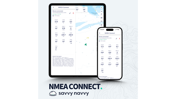
    Marine navigation company Savvy Navvy introduces a new NMEA Connect feature that seamlessly integrates NMEA-enabled boat instruments with the app, providing real-time data and enhanced AIS visibility.

    Working with award-winning Actisense, recognized globally for their NMEA interconnectivity specialty, Savvy Navvy’s new NMEA Connect feature enables boaters to view real-time data including wind, depth, engine RPMs, speed through water, heading and more in the app.

    By combining onboard and over-the-horizon AIS, NMEA Connect delivers a complete view of nearby vessels for safer, smarter navigation. Through NMEA Connect, boaters can now access their boat’s instruments and Savvy Navvy’s smart routing technology from their pocket, eliminating the need to switch between multiple screens or devices.

    “Boaters increasingly seek apps that simplify navigation and enhance onboard intelligence. NMEA Connect combines the proven reliability of NMEA technology with Savvy Navvy’s smart routing capabilities, giving boaters everything they need in one place. For boats without NMEA-compatible chart plotters, Savvy Navvy now becomes your all-in-one display,” says Misha Vysokovskiy, chief product officer at Savvy Navvy.

    Actisense, global specialists in marine electronics, help leisure and commercial operators build safer, smarter and more dependable onboard networks.

    “Savvy Navvy already delivers a huge amount of value to boaters, pulling together geographic location and environmental data streams. The addition of NMEA data connection means that other integral navigation and systems data will give boaters better visibility of things like depth, speed over ground, wind speed, heading and engine RPM — all within the easy-to-use Savvy Navvy app. Actisense are proud to have partnered with Savvy Navvy, lending our NMEA specialism. We share company missions of making journeys safer and more efficient through better data,” says Justin Cohen, commercial director at Actisense.

    Savvy Navvy has had more than 3 million downloads globally. Unlike any other boating navigation solution, Savvy Navvy provides smart routing — giving users optimal routes and dynamic ETAs based on real-time data: departure time, chart information, weather conditions, tide, boat specifications and local regulations.

    The NMEA Connect feature comes just weeks after Savvy Navvy launched an industry-first new chart annotation tool and Three Point Fix, following requests from boating instructors to turn digital charts into interactive learning tools for the next generation of boaters.

  • New GAJT-410MS provides anti-jamming in marine environments

    New GAJT-410MS provides anti-jamming in marine environments

    The GAJT-410MS provides anti-jamming to marine vessels. (Image: NovAtel)
    The GAJT-410MS provides anti-jamming to marine vessels. (Image: NovAtel)

    Hexagon | NovAtel has released the GAJT-410MS in response to the increase of interference and jamming in marine environments worldwide. The GAJT-410MS is the company’s latest addition to its proven GPS Anti-Jam Technology (GAJT) for the commercial and defense marine markets.

    The low size, weight and power (SWaP) variant protects civil and military operations from interference and jamming, with jammer direction-finding capabilities for enhanced situational awareness in the marine environment.

    The GAJT-410MS provides dynamic protection on both GPS L1 and L2 bands, as well as Galileo E1, QZSS L1 and L2 and SBAS L1 to combat intentional and unintentional interference. If a vessel experiences jamming, the device’s direction-finding capabilities provide improved situation awareness of their RF environment to identify and locate the source of the jamming signals.

    The commercial off-the-shelf, non-ITAR solution is easy to install or retrofit onto existing fleets, enabling assured PNT for continuous operations, cybersecurity and safe navigation at sea, NovAtel said.

    Interference, both benign and malicious, is a challenge facing civilian and military operations. Commercial marine applications like shipping, tankers and bulk carriers are under threat from interference targeting their navigation and cybersecurity. Without assured positioning, these vessels can drift off-course and place the vessel, crew and cargo at risk.

    Nearshore marine applications like survey, construction and piloting also require reliable positioning for uninterrupted operations in crowded waterways and RF environments. Interference mitigation and jammer direction-finding for advanced situation awareness ensure users acquire assured positioning, navigating and timing (PNT) while identifying and limiting risk from interference sources.

    “Assured navigation and cybersecurity defenses are growing priorities for marine users as global threats from interference and jamming increase,” said David Russell, marine segment portfolio manager for Hexagon’s Autonomy & Positioning division. “The GAJT-410MS is an anti-jam solution protecting vessels from interference and jamming disruptions to ensure continuous operations wherever your application takes you. With GAJT, your position, navigation and timing are protected and assured.”

    The GAJT-410MS is the latest iteration of proven, high-performance anti-jam products from NovAtel. It includes flexible mounting options, jammer presence and direction-finding capabilities for advanced situation awareness.

  • Veripos offers LD900 quad-band GNSS receiver for marine environments

    Veripos offers LD900 quad-band GNSS receiver for marine environments

    Photo: Veripos
    Photo: Veripos

    Veripos has released the LD900, a quad-band GNSS receiver capable of tracking GPS, GLONASS, BeiDou, Galileo and QZSS constellations to provide reliable and accurate positioning. Access to multiple GNSS signals allow for better satellite availability and reduce the impact of satellite masking or blockage, which can affect positioning.

    LD900 also receives L-band signals on multiple channels, providing access to the worldwide independent correction links and services provided by Veripos. With correction data available simultaneously from up to three correction satellites, the impact of satellite masking can be minimized to ensure reliable reception of correction data. Using the independent L-band RF input on the LD900 allows the connection of a dedicated L-band antenna ensuring optimal reception of correction services, especially at high latitudes, the company said.

    Veripos provides accurate and reliable positioning for all marine applications via their redundant positioning and multi-frequency precise point positioning (PPP) Apex and Ultra services.

    The Apex5 correction service utilizes all GNSS constellations delivering 5cm positioning accuracy for use in the most demanding offshore applications. Real-time kinematic (RTK) corrections can be utilized by the LD900 for applications where this service is required.

    The intuitive color display and navigation menu makes setup, configuration and system status monitoring simple. The display also helps troubleshoot issues with the LD900 allowing faults to be quickly diagnosed and resolved. The LD900 can also be configured remotely through the Veripos Quantum software.

    Features and Benefits

    • Supports decimeter-level multi-constellation positioning with Veripos Apex and Ultra PPP correction services
    • Multi-channel L-band allows simultaneous tracking of 3 Veripos correction service satellites
    • Independent L-band RF input
    • Easy-to-use, intuitive, color display for simple configuration and monitoring
    • Advanced signal filtering mitigates the effects of interference from other transmitters
    • Optional ALIGN GNSS heading solution
    • Optional MSK Beacon receives corrections from IALA marine radio beacon network
    • Automatic 72-hour rolling data log for incident support