Tag: Mark Sampson

  • Racelogic releases Galileo update for SatGen software

    Racelogic releases Galileo update for SatGen software

    Image: Racelogic
    Image: Racelogic

    Racelogic Ltd. has released the latest update to its SatGen GNSS simulation software for PC, which now incorporates Galileo RF simulation.

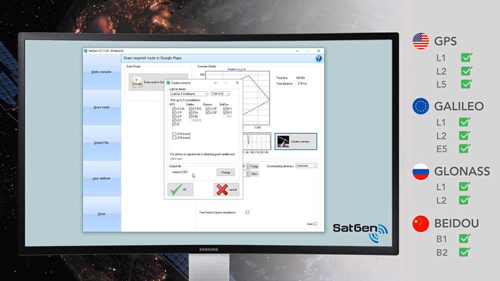
    Designed to create a GNSS RF I&Q or IF data file based on a user-generated trajectory file, the updated software can now accurately simulate the European Galileo GNSS satellite constellation alongside existing GPS, GLONASS and BeiDou RF signal generation.

    The full range of Galileo frequencies that SatGen can simulate are Galileo E1 B/C, E5a, E5b and E6 B/C (see below for details).


    SatGen 3.11.39 Galileo simulated RF frequencies

    Galileo E1 B/C. Transmitted by all Galileo satellites on the E1 (1575.42 MHz) frequency, same as GPS L1. Standard precision Open Service signal consisting of Data component B and Pilot component C.

    Galileo E5a. Transmitted by all Galileo satellites on the E5a (1176.45 MHz) frequency, same as GPS L5. Open Service signal consisting of Data component I with the F/NAV navigation message and Pilot component Q. Intended to be used together with E1 B/C to improve accuracy.

    Galileo E5b. Transmitted by all Galileo satellites on the E5b (1207.14 MHz) frequency, same as BeiDou B2. Open Service signal consisting of Data component I with the I/NAV navigation message and Pilot component Q. Intended to be used together with E1 B/C to improve accuracy.

    Galileo E6 B/C. Transmitted by all Galileo satellites on the E6 (1278.75 MHz) frequency. High accuracy Commercial Service signal consisting of Data component B and Pilot component C. Because the content of the C/NAV navigation message is encrypted, SatGen transmits a dummy navigation message, which should be accepted by all receivers.


    “Given the vast improvements in navigation and timing that Galileo has brought to its global users, we extremely excited to be releasing a version of SatGen that allows engineers to generate Galileo-specific scenarios for their test procedures,” said Mark Sampson, LabSat product manager.

    Other changes to the software include various user interface tweaks, performance optimization and fixes.

    For more information on SatGen, contact Katie Harland or call Racelogic LabSat at +44 1280 823 803.

    SatGen simulation software now features Galileo RF simulation from Racelogic VBOX on Vimeo.

  • Expert Advice: A Leap into the Unknown?


    By Mark Sampson

    A leap second will be introduced this year at 23:59 on June 30. This phenomenon comes around periodically and is necessary for keeping Coordinated Universal Time (UTC) in line with the small vagaries of the Earth’s slowing rotation. Although it is an event that will pass unnoticed by the majority of people, it has implications for anyone involved in the development of GNSS-enabled devices. For some, it can be the cause of a major headache.

    Part of the problem with the leap second is its irregularity. Occurring every two or three years, it means that receiver technology moves on in between — and because the Earth’s slowing rotation is not at a constant rate of change, it cannot be predicted when the next one will be announced. A rapidly developing market of GNSS products having to deal with random alterations to its time framework is not an ideal situation. Suitable preparations, clearly, should be employed.

    The behavior of a new receiver when subjected to a leap second may prove critical in certain instances, and without robust characterization it can lead to inconsistent performance. It has already happened this year: on January 21, GPS signals started to include information which effectively announced this year’s leap second event, with the relevant data for future delta time, and week and day numbers. This caused issues with some receivers that weren’t expecting it: some units applied the additional second immediately. It would be interesting to see how these systems might have reacted during an actual leap second transition.

    Receiver logic flow requires testing so that any GPS receiver can remain compliant with the IS-GPS-200 standard, and potential problems must  be mitigated and controlled. The use of a GNSS simulator — which outputs a scenario containing the leap second event — allows for the receiver and any systems around it to be exercised over and over again, ironing out any anomalies, to ensure total reliability.

    The recent issues with those non-compliant GPS engines highlights the advantage that simulation provides. The consistency it delivers enables a very thorough testing schedule, which will in turn lead to a straightforward application of the time change.

    One school of thought holds that leap seconds should be abandoned, and that we should stick to atomic time from now on. Their removal would mean that by 2100, the Earth’s rotation would be some two to three minutes behind humanity’s precise, atomic-powered, 24-hour clock, and half an hour or so by 2700.

    The World Radiocommunication Assembly, which has control over such matters, had been postponing a decision on whether to abolish the leap second for over a decade; another vote is due this year. It wouldn’t be any great wonder if this prevarication continues, so whilst it still exists, it is best to concentrate on what this June’s extra second might have in store for anyone currently developing a GNSS product. Armed with a simulator, the unpredictability of leap second scheduling should no longer be a major concern. Should this year’s vote be again inconclusive, those who have taken the positive step of acquiring a GNSS simulator will be in good shape to deal with the next time the clocks show 23:59:60.


    Mark Sampson is LabSat product manager for RaceLogic.

  • Expert Advice: Get Sporty

    Expert Advice: Get Sporty

    mountain bikers, with navigation device

    By Mark Sampson

    In recent years, the sporting world has seen an explosion in the use of GPS. You will rarely spot a runner or cyclist on the road without either a smartphone strapped to their arm or a dedicated GPS device clamped to their handlebars, tracking their every move.

    The amount of information that the modern sportsperson — from casual amateur to full-time professional — logs, analyzes, and shares is phenomenal. There are now dozens of ways of uploading data for the whole world to share and study.

    As more manufacturers come to this market with the hope of capturing a share of it, they face the challenge of effectively developing and then testing their devices. Among many factors to consider, new products must have capability for local constellations such as BeiDou, GLONASS, and QZSS, not just GPS alone. New market entrants won’t have the same budget as the established big players, and constantly traveling to China or Japan to try out a new gadget will escalate costs to an unsustainable degree.

    Then there’s the issue of getting out into the kind of environment in which you imagine your new sporting GPS device will be put to use. In many cases this will be remote: forests, hills, and mountains. Stepping outside to the office car park does not constitute a sufficient test for satellite acquisition and retention. Neither does simply driving the commute route home with it.

    A GPS simulator or replay device allows for bench testing, but such devices are expensive. They might not actually fulfill your testing requirements, either: a traditional GPS simulator outputs its scenarios based on constellation modeling, either as a perfect signal or one that has simulated multipath. But you need to genuinely know how your new product will operate through, say, a forest on a downhill mountain bike run, or during a city marathon through urban canyons, or on a trail under wet trees. Adventure sport participants want to record their achievements wherever they go.

    How do you obtain this kind of realistic scenario? It will require the use of a GNSS recorder, and in an ideal world you would lend it to someone who actually does some of this stuff. Perhaps one of your colleagues is an (insane) downhill skier — who better to capture exactly that type of data, which you can replay back in a nice warm lab?

    The trouble is that a person of this sporting ilk will be unwilling or unable to carry bulky equipment that weighs several kilos. It will slow them down, so a GNSS recorder that can be easily carried without affecting the sporting activity is essential. It has to be easy to use: self-contained, with a battery that will last a couple of hours, and with one big button to start and stop recording. The user shouldn’t need any training in its operation. And ideally, it won’t need a large ground-plane antenna to capture usable data; a well-designed unit will employ a sensitive GPS engine allowing for as complete a signal as possible to be logged through a standard passive antenna.

    Looking further afield, other industries will soon be seeking a device with this level of convenience. For instance, agricultural and automotive manufacturers want the ability to send test engineers out to record drive-cycle tests easily and in a variety of vehicles. Additional features, such as controlled area network (CAN) and inertial sensor logging, synchronized with the GNSS data, will also find favor.

    The nature of the simulation market is changing: increasing numbers of developers need not just a traditional constellation simulator, but rather a replay device that is feature-rich and that doesn’t cost the earth.
    Economies of scale will likely dictate the way that this develops, and GNSS simulation will no longer be the specialist and exclusive field it once was.


    Mark Sampson is the LabSat product manager for  RaceLogic, based in Buckingham, UK.