Receiver maker Septentrio, based in Leuven, Belgium, has made a series of announcements this year that push the industry forward, from updating existing receivers to accepting new services to launching new product lines.
Head of the CLAS
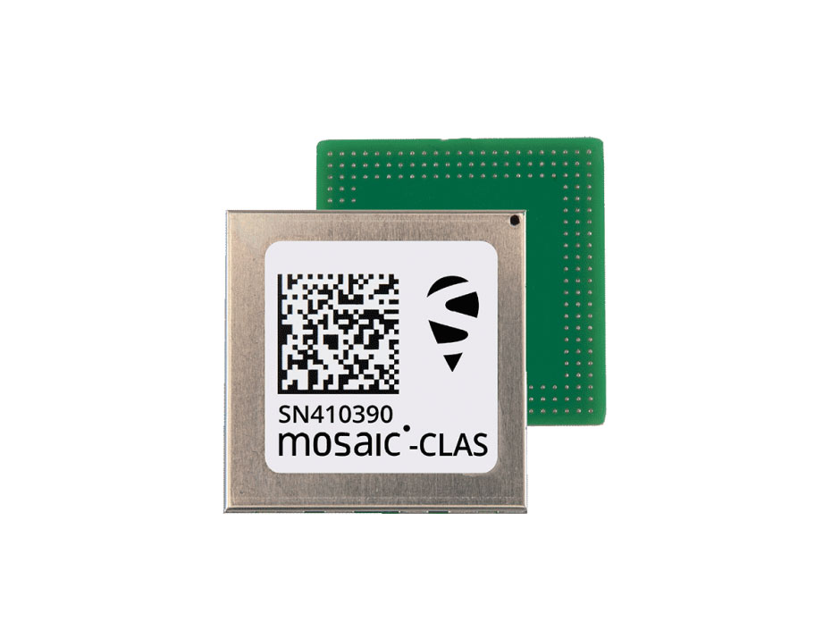
In March, the company launched three new products that support Japan’s high-accuracy Centimeter Level Augmentation Service (CLAS). CLAS, which receives the L6 signal, transmits high-accuracy corrections from Japan’s QZSS constellation. The technology was developed in close cooperation with CORE, a leading integrator of high-accuracy positioning technology and services in Japan.
Photo: Septentrio
Septentrio now offers the mosaic-CLAS receiver for high-volume industrial applications; the AsteRx-m3 CLAS that combines PPP-RTK CLAS with dual-antenna heading functionality; and the AsteRx SB3 CLAS in a ruggedized IP68 enclosure to protect it in harsh environments.
Septentrio is simultaneously offering various receiver types to the Japanese market ensuring an optimal match between products and customer needs in various applications including robotics, precision agriculture, construction, machine control and UAV.
Stopping the Spoofs
Following the CLAS upgrade, the mosaic line received another boost in April, when Septentrio announced Open Service Navigation Message Authentication (OSNMA) functionality. OSNMA offers end-to-end authentication on Galileo’s civilian signals, protecting receivers from OSNMA attacks.
For the past two years, Septentrio has been working closely with the European Space Agency (ESA) during the test phases of OSNMA deployment. The know-how gained during this period allowed Septentrio to be one of the first to market with this advanced security feature.
OSNMA’s anti-spoofing capability complements Septentrio’s Advanced Interference Mitigation (AIM+) technology and further strengthens the overall security of Septentrio GNSS receivers, making them suitable for assured PNT solutions as well as critical infrastructure, such as 5G network synchronization.
Vertical Markets
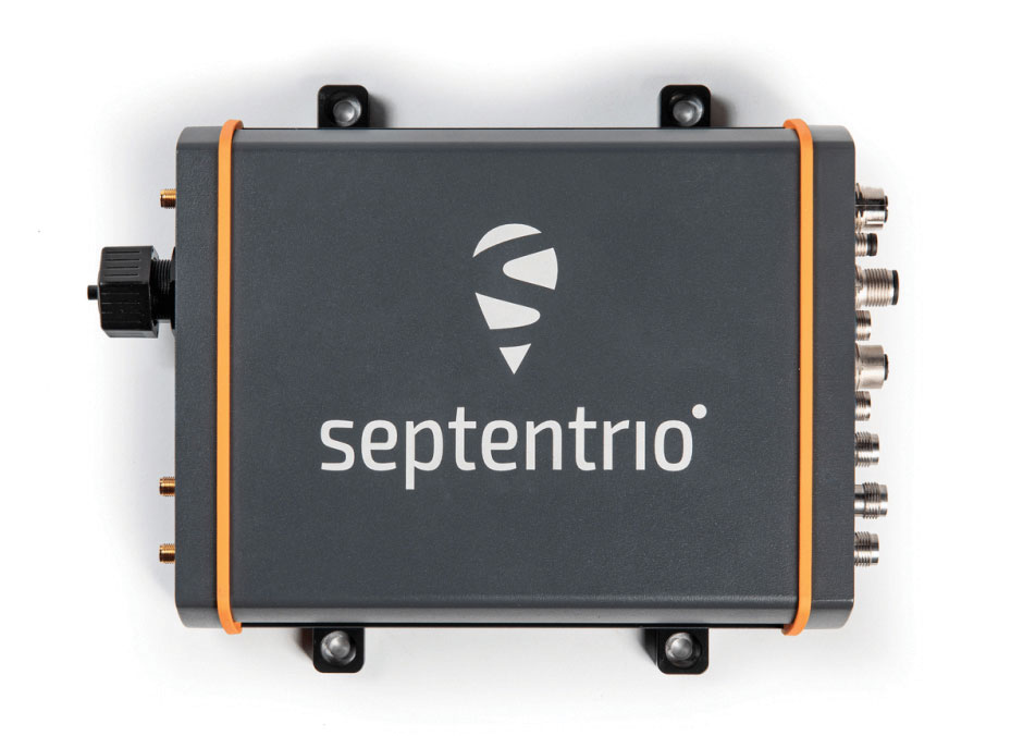
Machine Control. In April, Septentrio launched the AsteRx-U3 ruggedized GNSS receiver, successor to the AsteRx-U for construction, mining and other machine control applications. The new receiver combines Septentrio’s latest triple-band precise positioning GNSS core with extended wireless communication features including Wi-Fi, UHF and 4G LTE. The versatile connectivity features of this receiver make it easy to fit it into any control system and enable simple and cost-effective overall design.
Photo: Septentrio
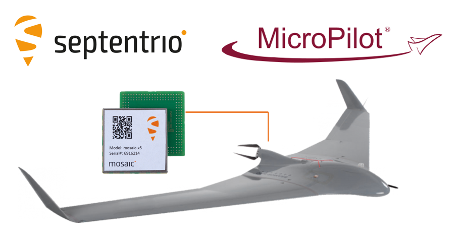
Unmanned Aerial Vehicles (UAVs). Also in April, Septentrio is collaborating with MicroPilot, maker of professional UAV autopilots. Septentrio receivers, including the small form factor mosaic modules, as well as the OEM board AsteRx-m3, will support seamless integration of positioning and orientation into MicroPilot’s autopilot ecosystem. MicroPilot chose Septentrio GNSS receivers for their resilience to radio interference such as jamming and spoofing, as well as security and robustness with high-accuracy real-time kinematic (RTK) positioning.
Marine. In May, Septentrio introduced the housed AsteRx-U3 Marine and the OEM board AsteRx-m3 Fg, two receivers for dredging, marine construction and offshore applications. Both offer accurate positioning near shore and offshore via centimeter-level real-time kinematic (RTK) or the built-in Fugro precise point positioning (PPP) sub-decimeter subscription service, delivered either over NTRIP internet or over L-band satellite.
Corrections delivered over L-band allow dredging, bathymetry or marine construction projects even in areas where there is no internet service. The AsteRx-U3 Marine receiver, enclosed in an IP68-rated housing, offers a dedicated L-band demodulator with a separate L-band RF input, which allows for the use of dedicated antennas for excellent reception of L-band signals even at high latitudes.
The collaboration ensures smooth and easy integration of high-accuracy GPS/GNSS positioning and professional-level autopilots into control systems where safety and reliability matter
Septentrio is collaborating with MicroPilot, maker of professional UAV autopilots.
Septentrio receivers, including the small form factor mosaic modules, as well as the OEM board AsteRx-m3, will support seamless integration of positioning and orientation into MicroPilot’s autopilot ecosystem.
MicroPilot chose Septentrio GNSS receivers for their resilience to radio interference such as jamming and spoofing, as well as security and robustness with high-accuracy real-time kinematic (RTK) positioning.
Self-interference or self-jamming is a common occurrence in UAVs, where devices such as cameras, servos or antennas, which emit electromagnetic radiation, are located close to the GPS receiver. Incorporating GNSS technology that is resilient to jamming and spoofing, in combination with reliable professional-level autopilots, is key to safe and secure flight navigation, according to Septentrio.
“Adopting new and resilient technology in UAVs is vital, and we want to ensure a smooth integration process into professional drone systems,” said Gustavo Lopez, senior market access manager at Septentrio. “We are very excited about the strong collaboration between Septentrio and MicroPilot, which now provides new alternatives to drone companies looking for safe and reliable flight operations.”
In addition to developing autopilots, MicroPilot provides supporting software and services that enable customers to use development time more efficiently, reducing time to market.
“Working closely with Septentrio gives MicroPilot the ability to better leverage resilient and robust GNSS technologies strengthening our offering to the professional UAV market for safe and reliable flight control,” said Howard Loewen, president of MicroPilot.
At Xponential 2019, MicroPilot President Howard Loewen discusses how the company has integrated the Trimble MB-Two receiver and Trimble BD940 receiver into its product line.
MicroPilot received a $2 million contribution toward its $5 million project to develop systems and processes that will allow certification to DO-178C airworthiness standards. In other words, MicroPilot aims to demonstrate a level of software reliability that will allow regulators to permit UAVs to operate over cities and towns.
MicroPilot is leading the Hi-Rise research consortium, a group of companies from different nations that is working to help achieve this goal.
“This is such a large project because the software and certification process for DO-178C compliance is complex and difficult,” said Howard Loewen, president of MicroPilot. “MicroPilot and the Hi-Rise consortium are always looking for new and innovative ways to assure regulators that the software is reliable.”
According to MicroPilot, it will use this contribution to further its goals to improve the regulatory and software certification framework for UAVs.
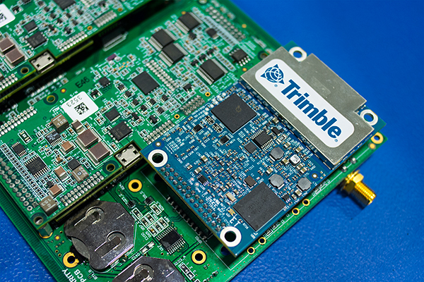
MicroPilot Inc. has teamed with Trimble to integrate high-precision GNSS technology as part of its autopilot for guidance and control of unmanned aerial vehicles (UAVs).
With centimeter-level, real-time kinematic (RTK) positioning capabilities, Trimble’s multi-constellation GNSS receivers are capable of tracking signals from GPS, GLONASS, Galileo and BeiDou, the company said. Trimble GNSS receivers are used in a wide variety of applications ranging from port automation and robotics to autonomous vehicle guidance.
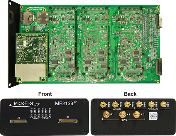
MicroPilot develops and manufactures autopilots for UAVs, including the triple-redundant MP21283X. The company also provides support products that enable customers to use their development time as efficiently as possible and bring their products to market faster. These products include the trueHWIL2 UAV autopilot simulator and the XTENDERmp software development kit.
The MP21283X UAV autopilot. (Image: Micropilot)
Working closely with Trimble gives MicroPilot the ability to better leverage Trimble’s GNSS technologies. This access improves the ability of MicroPilot’s support team to assist customers with their product development, testing and operations. Trimble will benefit from MicroPilot’s extensive experience integrating guidance, navigation and control systems for a wide variety of UAV platforms, the companies said.
“Reliable, robust and innovative GNSS solutions as well as strong technical support is key to bringing any UAV to market and our relationship with Trimble will allow MicroPilot to improve on our already industry-leading support,” said MicroPilot president Howard Loewen.
“We are very pleased to be working closely with MicroPilot to provide high-precision GNSS for its UAV autopilot solutions,” said Joseph Carey, director of strategic initiatives for Trimble’s Integrated Technologies Division. “MicroPilot autopilot’s simple installation, configuration and customization capabilities allow UAV manufacturers to easily integrate reliable, state-of-the-art, professional guidance, navigation and controls to their aerial platforms.”
MicroPilot is working with Simlat to develop a pan, tilt and zoom payload simulation tool to help improve the camera-centric parts of MicroPilot’s autopilot software.
Simlat is a provider of training systems for UAVs, enabling training on any platform with any payload for any mission. The tool Simlat has developed emulates a camera payload on a UAV, including simulated video, when set up with an “iron bird.”
This allows more testing to be performed on the ground, and potential problems with the payload worked out before flight testing begins.
“Flight testing is time consuming and expensive and simulation is an essential tool that reduces the amount of flight testing necessary to bring a drone to market,” said Howard Loewen, president of MicroPilot. “We are pleased to be working with Simlat to add this capability to our software development process.
“MicroPilot is always looking for useful tools and features to integrate with our products in order to help deliver more capable and reliable products to our customers. This camera payload emulator is just one of many third-party tools we have incorporated into our testing and development and yet another way MicroPilot has shown its dedication to product quality and performance.”
MicroPilot is an ISO 9001 autopilot manufacturer to bring to market an ISO 9001 sub-30-gram autopilot, triple redundant autopilot, and full-function general-purpose autopilot. MicroPilot offers a family of lightweight UAV autopilots that can fly fixed-wing, transitional, helicopter and multirotor UAVs.
Drone operational rules have quite a few restrictions, largely aimed at keeping unmanned aircraft away from manned and commercial aircraft operations. The Federal Aviation Administration (FAA) has set a boundary limit for UAV operations to stay a minimum of 5 miles away from any airport. So it’s a little surprising that at least one airport is actually carrying on trials to fly drones within airport property.
The reason is birds. Most airports are large, open spaces where birds love to land in large numbers to seek food and to rest, so airports and aircraft have to cope with the problem of avoiding bird-strikes in the critical phases of take-off and landing.
Airports have used remotely compressed air cannons, and manually fired ordinance that “screams” or explodes making various forms of loud noise, or dogs or even hunting falcons of different species. Birds, however, become habituated to cannons and guns, and neither dogs nor hunting falcons can be relied on to actually herd birds away from runways.
All this is in an effort to drive flocks of birds away from runways and low-altitude aircraft traffic corridors. At high altitude, a bird strike is usually survivable and an aircraft still has sufficient energy to be able to glide in the event of a complete engine-out situation, giving the pilot time to find a landing place. U.S. Air’s Chesley Sullenberger was a great airman to save his passengers and aircraft, but he was also lucky to have the Hudson right there to ditch into. He was some cool dude when he put his Airbus A320 down on the river, once losing both engines at low altitude on take-off after flying through a flock of Canada Geese.
Enter Robird, a drone that looks — and behaves, in the right operator’s hands — like a female peregrine falcon, with flapping wing propulsion and attack moves emulating the predatory bird. Flown by a pilot and accompanied by an observer whose primary job is to ensure the UAV “bird” stays away from runways, the pair seeks resting flocks of birds that pose risk to aircraft within the boundaries of an operational airport.
https://youtu.be/-gc8kBmzOOI
Clear Flight Solutions in Holland has recently undertaken a trial at Edmonton airport in Alberta, Canada, where it obtained special flight clearance to fly within the airport grounds to demonstrate how its mechanical falcon could clear birds away from airport danger zones.
Of course, drones and aircraft don’t mix either, so flight rules within the drone systems (GPS/autopilot?) apparently include geofenced no-go areas corresponding with runways and approach areas, and there is a shutdown mode in case of loss of signal or other failure — avoiding runway incursion is all important.
Registration is back on
Since U.S. Federal Aviation Administration (FAA) regulations requiring registration of small UAVs (sUAV) and model aircraft were struck down last spring by the appeals court, the need to register has been in abeyance. However, Congress has rolled a new requirement back into the recently signed $700 billion National Defense Authorization Act, making registration of any sUAS or recreational model aircraft a legal requirement, subject to fines for lack of compliance.
The FAA has continued to advocate registration as a means to track wayward operators and to enforce separation of drones from manned aircraft. AUVSI has also continued to support the FAA position. A 2012 law, on the other hand, was said to prevent the FAA from making rules covering “model aircraft,” defined as “unmanned aircraft” flown for recreational purposes.
The new regulation within the Defense Authorization Act has now apparently clarified and overcome any contradictions — recreational model aircraft and drones all have to be registered.
DJI claims and counter-claims
The U.S. Immigration and Customs Enforcement’s (ICE’s) recent claims that manufacturer DJI could be spying for the Chinese Government have been refuted by DJI.
DJI has responded that allegations are wrong and that ICE should consider withdrawing or correcting unsupportable assertions. But claims persist that the Chinese government may be using information gathered by DJI UAVs to target potential assets for purchase.
A large wine producer in California used DJI UAS to survey its vineyards and monitor grape production, but soon afterwards a number of Chinese companies apparently purchased vineyards in the same area. So it’s being alleged that the companies appear to somehow have used DJI data.
DJI UAVs collects reflective images of leaves to calculate the nitrogen levels of plants using a specialized infrared scanner. The scanner enables growers to deduce how much nitrogen to add to the soil to optimize plant growth. Information on the location and stages of crop growth can also be collected. As of May, it’s been reported that DJI’s only customers using this particular scanner were wine producers along California’s Pacific Coast.
Most UAVs would seem to be capable of collecting location and geographic information data; however, these claims are being leveled at manufacturer DJI. In a website statement, DJI denied any wrongdoing but hinted that some of its data storage may have been compromised.
This story may be far from over.
Potential new aircraft control systems?
I recall climbing around in the fuselage of a Jet Provost training jet back in my apprenticeship years at BAE in the UK — I was wiring in auxiliary systems. But the thing I remember most was the mass of control cables running down the top center of the aircraft and winding their way to control surfaces via pulleys, with in-line tensioners and rubber lined holes to pass through bulkheads. I thought, How reliable could this be? Of course, it’s the way almost every aircraft control system has been constructed since Wilber, Orville and wing-warping. Up until we got fly-by wire and electrical actuators, that is — then mechanical cables became less prevalent, except for reversionary back-up.
But making surfaces pop up into the airstream around an aircraft is how we’ve been able to take off, maneuver and land aircraft/UAVs — up to now. Elevators, rudders, ailerons, leading and trialling edge flaps, speed brakes — all of them control pitch (up and down), yaw (left to right), roll and manage lift. These mechanical control surfaces sprout out of the wings and horizontal and vertical stabilizers, and provide control for the pilot, autopilot or onboard flight computer.
Now BAE Systems and Manchester University (MAN U) in the UK have come up with a different way to control a flying vehicle without using moving control surfaces. If the smooth surfaces of a stealth aircraft were to be never disturbed, the stealth radar signature of the vehicle would remain unchanged even during maneuvering — a handy enhancement to have to keep an aircraft as invisible as when it’s “clean” in level flight.
The BAE/MAN U innovation, incorporated into a new MAGMA drone, uses internal, redirected air from the engine to “blow” the aircraft into a different direction. The small demonstration UAV has apparently completed a successful first flight.
These innovations could both reduce mechanical complexity and improve the integrity of a stealth signature, by removing conventional control surfaces. Wing circulation control redirects supersonic air from the engine and blows it through the trailing edge of the wing. Thrust vectoring changes the direction of the aircraft’s exhaust.
When used together, these control the direction of the aircraft by manipulating the air around it. Hydraulic and electrical actuators have been replaced by air redirecting ducts and air blowers, which may simplify build and flight controls without making the air vehicle more visible to radar. Of course, taking additional airflow from the engine means the engine has to be more powerful to provide the additional airflow, so this doesn’t come for free.
The technologies being developed may enable cheaper, higher performance, next-generation aircraft. Its hoped that R&D will contribute towards technological improvements for advanced military aircraft. These trials are an important step forward in the exploration of adaptable airframes — along with other work to improve the performance of UAVs in collaboration with the University of Arizona and NATO Science and Technology Organization.
MicroPilot adds sense and avoid
MicroPilot in Manitoba, Canada, is a leading supplier of autoflight solutions for the UAS industry. The latest MicroPilot autopilots include integrated control datalinks, and they are small, lightweight and interface with a wide range of sensors. MicroPilot has now integrated its UAV autopilot with the FLARM sense and avoid system, adding an essential element for autonomous and beyond-visual-line-of-sight (BVLOS) operations.
FLARM is a traffic awareness and collision avoidance technology used by light aircraft and UAVs. When integrated with MicroPilot’s autopilot, the system alerts the autopilot of any close-by, suitably equipped aircraft. FLARM outputs the velocity and altitude of these detected targets, and the autopilot then decides how to avoid them.
FLARM collision avoidance systems, used by manned aircraft for more than a decade, now come with an ADS-B out option that broadcasts the UAV’s position to alert other aircraft to its location. Together, the MicroPilot autopilot and integrated FLARM system offer a unique combination of automated flight control and sense-and-avoid capability for UAS developers.
Summary
So bird-hunting, wing-flapping, bird-like UAVs being used to clear airports to prevent collisions between birds and aircraft; you will need to put down your $5 registration fee with the FAA if you want to fly your own UAV because new legislation has replaced that previously struck down in the courts; DJI and the U.S. ICE seem to be on some sort of a collision course; BAE and MAN U appear to be on the verge of a potentially revolutionary system with which to affect flight control of aircraft and a combined system for autoflight and collision avoidance — just a few of the many things happening this month in the UAV industry.
Sponsored by: Hemisphere GNSS Original Broadcast Date: Thursday, November 21, 2013
Moderator: Tony Murfin, Editor, Professional OEM newsletter
Speakers: Olivier Casabianca, Business Area Manager, Trimble GNSS OEM; Hal Adams, Co-founder/Chief Operating Officer, Accord Technology; Neil Gerein, Defense Product Manager, NovAtel; Eric Brewer, Senior Systems Engineer, Rockwell Collins; and Howard William Loewen, President, MicroPilot Inc.
Summary: In recent years, there has been explosive growth in the Unmanned Aerial Vehicle (UAV) market segment, with most on-board navigation systems relying on GNSS or GNSS with inertial aiding. As military budgets decline, interest in civilian commercial applications is growing rapidly. The FAA recently awarded special type certification to two UAVs for commercial Arctic operations, and the industry is now poised for the opening of the regulation floodgates to address a growing commercial demand. In this webcast, we will hear from some of the industry leaders in GNSS-based navigation for UAVs, in both the military and civilian sectors: they will tell us what they are doing in UAV navigation and where they see this exciting market going.