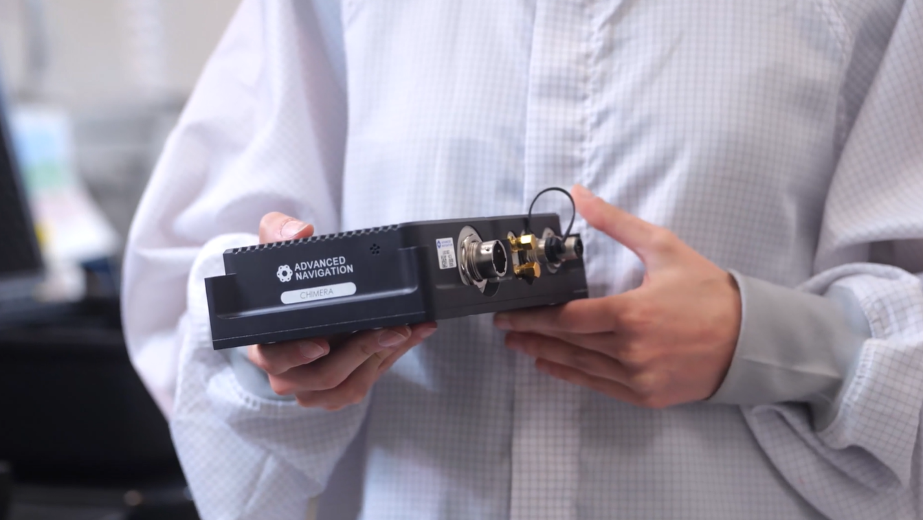
Advanced Navigation has released a product for navigating underground mines, based on its technology demonstration in October 2025.
Chimera Land is a 3D laser velocity sensor (LVS) designed to solve the primary challenge for underground mining: maintaining precise vehicle positioning in deep, dark, and unmapped environments where GPS cannot reach.
When fused with an Advanced Navigation inertial navigation system (INS), Chimera Land allows underground vehicles to maintain stable navigation over extended distances and time. Instead of needing to “ask” an external beacon or satellite for its location, the sensor uses specialized lasers to measure a vehicle’s ground-relative 3D velocity with high accuracy. By feeding this precise data into the vehicle’s INS, the sensor eliminates the drift that typically comes with standalone INS.
This integration uses AdNav Intelligence, the company’s proprietary software. Drawing on adaptive algorithms, the fusion engine dynamically weights the input from each sensor, adjusting reliance in real time based on their reliability scores, environmental conditions, and operational context.
The result is a resilient, high-performance, infrastructure-light positioning solution that excels in the high-dust, zero-light conditions typical of underground mines.
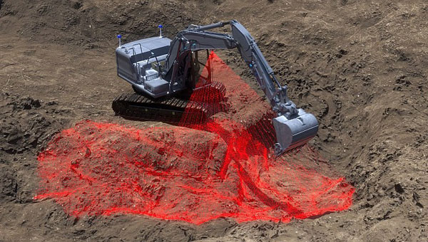
Chimera Land was demonstrated in Europe’s deepest underground mine as part of BHP’s Deep Mining Call. When integrated with Advanced Navigation’s high-performance Boreas D90 INS, the solution achieved a position accuracy of 99.9% of distance traveled. Crucially, this performance was maintained without relying on any fixed positioning infrastructure, pre-existing maps, or external aiding.
Key performance benchmarks:
Precision at depth. The system delivered a final position error of 15.9m over a 22.9km transit (approx. 52 ft over 14 miles) at 1.4km underground.
INS drift reduction. Chimera Land actively reduced the drift rate to a mere 0.07% per distance traveled.
Repeatable accuracy. Validated across five separate runs, the system consistently hit an accuracy of better than 0.1%.
Infrastructure-light. Enables full vehicle autonomy even where fixed networks and infrastructure end.
As mines move deeper and into more hostile geological frontiers, the cost of installing fixed infrastructure becomes prohibitive. Chimera Land is engineered to maintain high-confidence estimation in total darkness, heavy dust, and high-vibration mining environments.
It allows for “infrastructure-lite” operations across the value chain.
Autonomous haulage systems (AHS). Enables continuous high-speed tramming in development areas without the need for pre-surveyed beacons.
High-Precision machine guidance. Provides the sub-decimeter velocity accuracy required for automated drill rig alignment and robotic scaling.
Dynamic Fleet Management. Real-time, sovereign localization allows for precise asset tracking and ore reconciliation, even in the deepest “dead zones.
Predictive collision avoidance. High-fidelity 3D velocity data improves the “time-to-collision” calculations for safety systems, reducing nuisance alarms.
Sodex Innovations, an Austrian company specializing in construction surveying technologies, has unveiled the SDX-4DVision and SDX-Compact machine-mounted terrain mapping systems.
These systems integrate advanced sensor technology and artificial intelligence (AI) driven data processing to create digital twins of worksites while the machine operates. Data is uploaded to the SDX Cloud, allowing for real-time analysis from any location. This allows professionals to monitor evolving site conditions, track inventory through automated volume calculations, and make remote data-driven decisions.
The systems are designed for easy installation on various types of heavy machinery, such as wheel loaders and dozers, making them ideal for construction, mining and civil engineering projects. Their adaptability enables efficient data collection and site monitoring, making them accessible not only to professional surveyors but also to operators and team members who are involved in daily operations.
HxGN LIVE Global 2022, taking place this week in Las Vegas, is a cross-industry conference showcasing the latest technologies and innovations from Hexagon.
The first two days brought numerous announcements and demonstrations. Here are a few highlights.
Hexagon unveils mining smart platform
The new Power of One platform is a holistic, life-of-mine smart solution connecting sensors, software, infield apps and cloudware. Available and ready to implement, the technology connects the mine to the boardroom via a single onboard ecosystem. Harnessing data from multiple sensors in a simple and consolidated software architecture, the platform helps mines to become situationally aware, self-learning and autonomously connected in the field and in the cloud.
For the customer, the platform offers an effortless experience with a seamless UI/UX and consistent functionality. Reduced cost of ownership, reduced deployment and training time, reduced supply chain complexity and increased operator adoption are just some of the platform’s many benefits.
“The Power of One platform is a landmark enabler for next-generation autonomy,” said Nick Hare, Hexagon’s Mining Division president. “It offers mines a uniquely intelligent approach based on open architecture to autonomously connect key mining ecosystems, such as exploration, planning, drill and blast, material movement and mine monitoring. “It’s the scalable, platform-agnostic answer to challenges previously addressed by point solutions and multiple vendors.”
HxGN LIVE Global visitors can learn more about the Power of One platform during this week’s Intelligent Mining Summit.
Ola Rollén, president and CEO of Hexagon, delivers the keynote address at HxGN LIVE 2022. (Photo: Hexagon)
Hexagon and Fujitsu announce strategic partnership
Hexagon’s Safety, Infrastructure & Geospatial division and Fujitsu Limited will partner to accelerate the development and promotion of use cases to solve societal challenges and contribute to the realization of the “Trusted Society” — a sustainable, resilient place where people can live together in peace and prosperity.
Hexagon and Fujitsu will work together to provide joint use cases leveraging digital-twin technologies and solutions from both companies, including sensors, data processing, data analysis and advanced data visualization in the cloud and high-performance computing infrastructure. The partners will deploy these technologies to develop joint solutions that deliver richer information and deeper insight to customers in government, the public sector, transportation and utilities to help reduce emissions, increase safety, optimize operations and more.
“Our goal at Fujitsu is to realize our vision for a ‘Trusted Society’,” said Yoshinami Takahashi, EVP and vice head of Global Solution Business Group, Fujitsu. “Partnering with Hexagon will allow us to extend our reach and provide even greater value to cities and regions around the world.”
“Cities are playing a leading role in solving global challenges, from addressing climate change to eliminating traffic fatalities,” said Steven Cost, president, Hexagon’s Safety, Infrastructure & Geospatial division. “Our partnership with Fujitsu can help cities put data to work to solve these pressing problems and meet sustainability and safety goals.”
The new global partnership builds from the companies’ work to solve urban sustainability challenges in Europe, including efforts to better manage and understand the impacts of shared mobility services in Germany, including a project with the City of Munich.
Hex-E, the Hexagon mascot, peruses a map during HxGN LIVE 2022. (Photo: Hexagon)
HxGN EAM asset management software leads in Green Quadrant
HxGN EAM from Hexagon’s Asset Lifecycle Intelligence division was named a leader in the enterprise asset management (EAM) market in the Green Quadrant: Enterprise Asset Management Software 2022 report from Verdantix.
Verdantix is an independent research and advisory firm with expertise in digital strategies.
HxGN EAM received the highest weighted score for the technical capabilities of the platform. The report assessed 14 EAM software vendors across their product functionality, user interface and market momentum.
Verdantix estimates that global spending on EAM will reach $5.4 billion in 2026, compared to $3.6 billion in 2021, and states that acquisitions and funding are reshaping the EAM market. This comes just after Hexagon’s $2.8 billion acquisition of Infor’s EAM software business to form HxGN EAM in 2021.
“HxGN EAM’s growth ambitions align with the market outlook and Hexagon’s vision to be the world leader in digital realities and autonomous solutions,” said Kevin Price, vice president, Enterprise Asset Management Portfolio Segment, Hexagon’s Asset Lifecycle Intelligence division. “Asset visibility is the first step in proactive maintenance and the prevention of the breakdown of critical functions, and we’re proud that HxGN EAM’s wide availability of services matches the growing needs of our customers. It’s an honor to be classified as a leader in the EAM market.”
Hex-E gets excited about his reflection at HxGN LIVE 2022. (Photo: Hexagon)
Hexagon Elite Awards recognize customers
Hexagon’s Asset Lifecycle Intelligence (formerly PPM) division announced the recipients of the 2022 Hexagon Elite Awards, which honor Asset Lifecycle Intelligence division customers who are champions of progress and innovation using Hexagon solutions.
“As we expand our portfolio and capabilities through acquisitions, our customers’ designs and animations using Hexagon solutions for this competition continue to amaze,” said David Cryer, Senior Vice President & Chief Marketing Officer, Hexagon’s Asset Lifecycle Intelligence division. “It’s an honor to recognize this year’s winners and we want to thank all of our customers who submitted entries.”
This year’s awards were presented in six categories:
Best in Design recognizes the most innovative and well-executed uses of Intergraph Smart 3D, Intergraph Smart Review and/or CADWorx: Fandy Maulana, Reformer Petrochemical Plant, PT Rekayasa Industri (Rekind).
Best in Automation rewards the most innovative automation ideas for Intergraph Smart 3D, Intergraph Smart P&ID, Intergraph Smart Electrical and/or Intergraph Smart Instrumentation: Petrobras – Surface Systems Engineering.
Best in Analysis recognizes innovative applications of CAESAR II, PV Elite and/or GT STRUDL that helped successfully complete a project and meet design and engineering goals: Chengwen Wang, Wuhuan Engineering Co. Ltd.
Best in Operations highlights customers who are true champions of progress and continue to move their company and industry forward in digital transformation in the Operations and Maintenance segments: Sudharshan Nambiar, Engineering Data Management – Systems, Petronas.
Best in Project Performance recognizes customers who use Asset Lifecycle Intelligence division and EcoSys solutions to successfully complete a project or improve project performance: Yann Guyot, Cost Control & Risk Management, Technip Energies.
Best in Procurement, Fabrication & Construction Management honors the most innovative and well-executed uses of the Asset Lifecycle Intelligence division’s PF&C solutions to successfully complete a project or move the company and industry forward in digital transformation: Jingwei Zhang and Zhifang Li, Zhengzhou Coal Mining Machinery Shuyun Intelligence Technology Co. Ltd.
Submissions for the 2023 Hexagon Elite Awards competition will be accepted starting Nov. 1.
Photo: Hexagon
Hexagon and Mineral Resources partner on automated road-train solution
Hexagon’s Autonomy & Positioning and Mining divisions announced the development of an automated road-train solution with mining services company Mineral Resources Limited (MRL). To be deployed on MRL’s haulage fleet, the solution integrates drive-by-wire technology with an autonomous management system to orchestrate vehicle movement in road-train haulage.
The automated road-train solution focuses on safety, productivity and sustainability for MRL operations and will be phased in over the next two years. Both companies are confident that progressive automation will profoundly change the safety and economics of mining where macroeconomic challenges, including commodity prices and labor shortages, impact the feasibility of projects.
The automated road-train solution improves the safety of long-range haulage, provides cost-efficiencies and reduces emissions to assist companies in lowering their carbon footprint. Beyond mining, this innovative solution will also benefit bulk haulage in many other off-road primary industries.
“Autonomous vehicles are revolutionizing the way we work today and into the future, and Hexagon is very proud to be part of this revolution,” said Ola Rollén, president and CEO of Hexagon. “Our agreement with MRL further solidifies Hexagon’s commitment to autonomous mobility and fulfilling our customer’s safety and productivity requirements.”
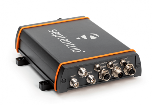
Septentrio has launched the AsteRx-U3 ruggedized GNSS receiver, successor to the AsteRx-U for construction, mining and other machine control applications.
The new receiver combines Septentrio’s latest triple-band precise positioning GNSS core with extended wireless communication features including Wi-Fi, UHF and 4G LTE. The versatile connectivity features of this receiver make it easy to fit it into any control system and enable simple and cost-effective overall design.
“We are excited to introduce AsteRx-U3 to the market of industrial automation,” said Silviu Taujan, product manager at Septentrio. “Its advanced connectivity package offers manufacturers and integrators access to reliable high-accuracy positioning in a system which is versatile, easy to use and easy to integrate.”
The AsteRx-U3 offers a unique feature, a guaranteed low latency of under 10 msec with a high data rate, which allows machines to work with rapid as well as accurate movements. An IP68-rated housing with fixing brackets and robust M12 connectors ensures a quick and reliable installation.
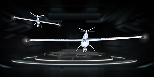
The Autel Robotics Dragonfish Lite and Pro UAVs are now available in the United States, joining the Dragonfish Standard and providing more options and choices for UAV pilots.
The rugged Dragonfish UAVs are capable of vertical takeoff and landing (VTOL) with both multi-rotor and winged flight, with an endurance of up to 180 minutes. They are suitable for professional applications such as energy, mining, defense and surveillance. Maximum winged flight speed is 30 m/s (108 km/h, 67 mph), and maximum video transmission range is 30 km (18.6 miles) with a base station.
The 1-tap take-off and landing capability point-and-click user interface, and other smart autonomous features make the Dragonish simple for anyone to operate, according to maker Autel Robotics. The aircraft can make a smart decision to either land or return to base in case of issues such as loss of GPS signal, loss of operator communications, or low battery power.
The Dragonfish tilt-rotor system will automatically transition to multi-rotor mode if adverse conditions cause fixed-winged flight to stall or become unsustainable. The Dragonfish battery, barometer, positioning system, compass and inertial measurement unit all have backup modules to ensure flight safety.
Dragonfish UAVs can carry a variety of payloads, including standard high-resolution cameras, 50x optical zoom cameras, 12-megapixel wide-angle cameras, 1280 x 1024 high-resolution infrared cameras, and laser rangefinders for various imaging, surveillance and mapping tasks.
All Dragonfish UAVs are built from tough carbon-fiber and fiber-glass composite, providing excellent IP43 wind and weather resistance. Despite the strong construction, these aircraft are designed to be easily disassembled for space-saving transport. They can be assembled in three minutes without tools. Disassembled, Dragonfish fits in the back of any car or SUV.
The larger Dragonfish Pro provides the longest flight time of the series, 180 minutes with payload, and has a 6,000-m (19,685-ft) flight ceiling, making it suitable for applications such as discreet long-endurance surveillance and wide-area mapping. The maximum payload capacity is 2.5 kg.
Compact and lightweight at 4.5 kg (including two batteries) with a 1,600-mm wingspan, the Dragonfish Lite can carry a 1-kg payload up to its service ceiling of 4,000 m, and has 75 minutes’ flight endurance.
Dragonfish Standard is already available. Dragonfish Lite and Dragonfish Pro will be available in the U.S. starting in April.
Firmware Release
The company also announced that pilots of Autel Robotics’ EVO Nano and EVO Lite series drones can download a firmware update that adds features including Dynamic Track 2.1 (person only), SuperDownload, 8-bit Log video, HDR video and other improvements. Some of these new firmware features are available now for selected models, and other features will become available for the EVO Lite, Lite+, Nano and Nano+ series in the near future.
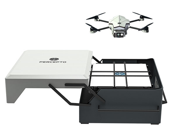
Percepto Air Mobile drone with base. (Photo: Percepto)
Percepto, an Israel-based company specializing in autonomous inspection with industrial robotics, has launched its 2022 Autonomous Inspection & Monitoring (AIM) platform and Air Mobile drone.
Recently listed in TIME magazine’s 100 Best Inventions of 2021, Percepto offers an end-to-end solution powered by artificial intelligence (AI) to collate and streamline all visual data for accurate actionable insights.
Percepto AIM 2022 has a new Insight Manager to deliver AI-powered packaged solutions for sector-specific use cases, such as solar, mining, energy, oil and gas and other industries. The company drew on tens of thousands of hours collected by autonomous robot missions at industrial facilities to create it.
Percepto’s AI change-detection framework offers unified visual data and critical business insights for each of the sector-specific solutions. AIM 2022 can be integrated with autonomous drones and robots as well as other visual data collectors, now including DJI drones, and fixed cameras.
Reports and insights are automatically generated based on the combined visual data. Disseminated to relevant stakeholders on any mobile device, issues and faults are geotagged and displayed on a map, enabling effective action before escalating into more serious problems.
Percepto also introduced its new Percepto Air portfolio to support the enhanced platform, which will address the diverse needs and increasing demands of various markets.
Percepto Air Max. The next generation of Percepto Sparrow, the Percepto Air Max is a field-proven solution that operates in the largest mining, oil and gas, and energy companies on six continents. It has a top-grade, versatile payload for specific use cases. Designed to inspect and map complex industrial environments where the highest accuracy and durability are critical, Air Max also has an optical gas imaging (OGI) camera.
Percepto Air Mobile. This option is a more compact and lighter weight model for smaller sites or organizations taking their first steps with a drone-in-the-box program, or larger sites that need greater deployment flexibility. It is designed for linear inspections, such as pipelines and power lines, and can monitor short-term projects across multiple sites, such as construction sites.
Percepto Air Max and Air Mobile drones are stored permanently onsite within their respective Percepto Bases. The Air Mobile’s base is light and easy to relocate while maintaining high levels of durability. These encasements are designed for infrequent maintenance and protection against extreme environmental phenomena, such as hurricanes. Percepto’s drones are safe and regulation ready, and ensure all operational aspects meet corporate standards.
“Percepto AIM 2022 and the new Percepto Air line of drones, together with the most advanced change detection solution, alert and prevent failures and downtime within diverse use cases across many industries,” said Percepto CEO Dor Abuhasira. “Percepto AIM provides the most advanced and comprehensive enterprise inspection software that offers a complete data workflow — from capture to insight. With Percepto Air Max and Percepto Air Mobile, companies have a range of options to choose from depending on the size of their facilities and the flexibility needed to deploy drones.”
“The real power of Percepto’s system is how data collection and analytics are integrated for a holistic view from both a technical and management perspective,” said Tim Shanfelt, director of Operations Transformation, Koch Ag & Energy. “Our workers are connected to high-level information that helps them make the right decisions while keeping them safe and free to pursue higher value activities. Our goal is to eliminate hazardous, wasteful, and mundane tasks from our operators’ day. For example, instead of an employee climbing an icy ladder in the winter, a robot or drone can perform the same task while still obtaining accurate measurements. We see Percepto playing a significant role in helping make our facilities more safe, secure, efficient, and profitable.”
Intelligent transport company Cohda Wireless is applying its vehicle positioning solution to the Oyu Tolgoi mine in Mongolia to drive safety and productivity.
In its first use for mining, Cohda’s V2X-Locate technology is being deployed at the Oyu Tolgoi copper and gold mine, managed by Rio Tinto, to provide vehicle and personnel location accuracy.
V2X-Locate was initially developed to solve vehicle positioning accuracy challenges inherent in the urban canyons of cities where large buildings, underground parking lots and tunnels interfere with GNSS signals. Using dedicated short-range communication (DSRC) signals, Cohda’s signal processing and positioning algorithms provide highly accurate vehicle position irrespective of GNSS availability or quality.
Cohda Wireless is headquartered in Australia and has offices in Europe, the United States and China. Its V2X (Vehicle-To-Everything) technology connects vehicles with each other and with roadside infrastructure to create a cooperative and intelligent transport environment.
The system can integrate and manage location data from multiple sensor types with sub-meter accuracy throughout the mine site, said Paul Gray, Cohda Wireless CEO. He called it a significant improvement on using a combination of disparate collision avoidance systems across the mining environment, as is usually the case.
“When you have hundreds of vehicles and personnel operating in close proximity underground, a meter matters. And whilst the prevention of injury and death is always the top priority, we also know that the ability to visualize, optimize and monitor vehicles brings significant operational benefits and efficiencies,” Gray said.
More than 200 mining vehicles of all types are being fitted with Cohda’s XBU-V specially adapted on-board units that connect vehicles to each other and to XBU-I roadside units installed in mine tunnels. Mining vehicles are fitted with a human-machine interface that will notify operators to warn them of potential collisions. More than 2,000 personnel will use V2X-Locate-compatible cap lamps, enabling time-of-flight analysis of wireless signals to resolve spatial locations.
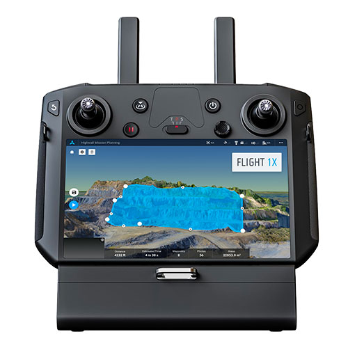
Skycatch is offering new data-capture capabilities for the DJI Matrice 300 through its proprietary Flight1x software — a key component of the company’s High Precision Package.
The High Precision Package provides mining operations with cloud or edge-based data processing that enables viewing terrain in 4D, automated RTK/PPK industrial drone management, and fast edge processing with data visibility in minutes.
Built on technology adopted by companies Komatsu Mining and AngloAmerican, Flight1x outperforms traditional off-the-shelf data mapping tools by including purpose-built flight automation software for the M300, leveraging DJI’s L1 and P1 sensors.
The solution delivers data and network security via Skycatch servers in the United States, coupled with advanced automation features like a 3D first-mission planner, mining-focused workflows and deep integration into Skycatch’s data analytics platform Datahub.
The Flight1x software will work with the M300 to help mining engineers quickly extract data. Features include:
fully automated capture, extraction and processing of high-precision 3D point clouds
highly specialized mission-planning automation to extract data from complex terrains such as high walls
complete industrial data capture and processing for repeatable and automated spot inspection
consistent data-retrieval analysis of thousands of terrain spots in a single location by an automated industrial drone
fully automated aerial robot technology built on Skycatch’s automation platform, eliminating the need for manual pilots and reducing risk of human error.
Geospatial mapping company GeoSLAM has expanded its mining offerings.
The company also announced an automated processing platform, GeoSLAM Connect, which provides users with the flexibility to process data to their specifications through interactive, customizable script-based workflows.
The new innovations can be used alongside GeoSLAM solutions already available, including GeoSLAM Volumes for stockpile volumetric calculations.
GeoSLAM Production Progress Mapping allows operators to make short-term decisions on newly mined production areas when coupled with the ZEB scanner and its own internal coordinate system. Once the data from each scan has been automatically processed and georeferenced using GeoSLAM Connect, it can be uploaded to compatible third-party software. Operators can overlap collected data and precisely visualize changes over time to compare with project plans.
Convergence Analysis provides mine owners with a rapid and cost-effective way to understand the environment while keeping miners safe by measuring rock support at a safe distance.
A shaft inspection cradle is built for collecting data during inspections and analyzing change. It allows users to understand the erosion of a shaft wall, view blockages and identify hanging points for ore in hard-to-reach shafts.
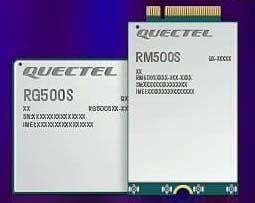
Quectel Wireless Solutions, a global supplier of modules for the internet of things (IoT), has announced the release of two new 5G New Radio (NR) module series, the RG500S and RM500S.
Based on the new Qualcomm 315 5G IoT Modem-RF System, both modules can support customers in building dedicated 5G devices for a variety of verticals including industrial IoT, retail, smart energy, private 5G networks, and many others.
The RG500S and RM500S both integrate a multi-constellation GNSS receiver, which simplifies the product design and provides accurate positioning services for users.
Utilizing the powerful Qualcomm 315 5G IoT modem, the RG500S and RM500S support extended-life software maintenance, helping create long-lasting IoT devices for the duration of their life span. Offering seamless integration, the RM500S is pin-to-pin compatible with Quectel’s LTE Cat 4 module EM05, Cat 6 module EM06, Cat 12 modules EM12-G/EM12xR-GL, Cat 16 module EM160R-GL and 5G module RM500Q, which provides more competitive 5G solutions to the IoT market. These features will help accelerate the 5G IoT market in the industrial and consumer IoT segments with use cases across robotics, automation, intelligent manufacturing, energy distribution, precision agriculture, construction, and mining.
Photo: Quectel
The RG500S and RM500S modules support 5G NR sub-6GHz bands in stand-alone mode offering backward compatibility with LTE networks. With network slicing in stand-alone mode, the two modules are able to offer end-to-end traffic isolation for critical traffic, guaranteed data rates and bandwidth, and lower latency than in non-standalone mode, which meets the demands of ultra-reliability and service-level agreements of typical industrial and enterprise scenarios.
The two modules are embedded with rich interfaces and incorporate high-speed USB 3.0/3.1, PCIe 3.0, U(SIM), RGMII and more, making them suitable for diversified industrial and consumer 5G applications such as industrial routers, robots, automation, intelligent manufacturing, smart cities, energy distribution, precision agriculture, construction and mining.
“Quectel has long been collaborating with Qualcomm Technologies to support the enablement of the 5G market in IoT,” said Patrick Qian, CEO, Quectel. “Based on the latest Qualcomm 315 5G IoT modem, the RG500S and RM500S are able to offer greater possibilities for the industrial and commercial IoT verticals. Features such as high performance and low latency as well as extended life software maintenance address the existing IoT market needs and can power a range of new 5G IoT use cases.”
“The Qualcomm 315 5G IoT modem solution was introduced to stimulate and scale the 5G IoT industry and enable the transitions needed to make 5G for IoT a reality. This solution is pin-to-pin compatible with legacy modules, which can accelerate device development and commercialization and promote growth and expansion in the 5G IoT industry. Integrating Qualcomm Technologies’ purpose-built modem into Quectel’s RG500S and RM500S modules will help deliver 5G to the IoT industry across industrial and enterprise applications,” said Jeffery Torrance, senior vice president, product management, Qualcomm Technologies.
Centimeter-level positioning and high-accuracy orientation of machinery enable automation of many construction, mining and farming tasks, and take them one step closer to being performed by autonomous machines. Machine control increases jobsite safety, operational efficiency and productivity.
Using data from GNSS satellites, total stations and 3D models, machine-control hardware and software solutions determine a machine’s current position on the Earth and compare it with the desired design surface, mining task or cultivation technique. They also monitor and sometimes control the position and orientation of implements — such as blades, buckets and seeders — with respect to the machine. By talking directly to the machine’s hydraulics, machine automation shifts responsibility for accuracy and speed from the operator to the technology.
On construction sites, automation guides motor graders, excavators, dozers and other heavy machines, making operations easier to manage. This makes contractors more productive and experienced operators more efficient. With this technology, less experienced operators are able to take on more complex tasks, and all operators become more accurate. Machine automation also increases the capabilities of the machines themselves, so that excavators and compact machines are now doing finish grade work once reserved for larger and more expensive dozers.
Operators in the cab and engineers and supervisors at their desks can control and monitor progress in real time, with views of the whole layout as well as specific slopes, roads, ditches and other elements, including those under water.
Using GNSS guidance to aid application of fertilizer, pesticides and herbicides saves time and money. (Photo: Septentrio)
About half of all motor graders and a third of all dozers use positioning sensors and a display to provide operators with the position of the blade with reference to the target grade. A typical machine control set-up consists of a GNSS receiver and a display (jointly referred to as a “cab kit”) and inertial measurement units (IMUs) on the blades and other implements.
From the display, the operator loads a project design, which tells the system the cut, fill and other design information it needs. The operator then chooses a lane and may choose a vertical offset, which temporarily adjusts the design grade, making it possible to accomplish the work in steps, from rough to finish grading. Operators can also record points and scan a pavement in real time as they repair it.
While used by the construction industry on earthworks equipment since the late 1990s, machine control has recently benefited from:
The increase in the number of GNSS signals available, particularly on the new L5 frequency
IMUs, which measure blade movements with respect to the machine 100 times per second, one order of magnitude more than non-IMU grade-control systems
The growing availability of continuously operating reference stations (CORS) and other GPS networks, which eliminate the need to set up a base
New mastless systems, which integrate a receiver into the top of the cab and connect it wirelessly with IMUs to orient the blade, obviating the need to install a long mast pole on the blade and connect it by cable to the receiver and improving safety, visibility and equipment durability
New interfaces designed to be as easy to use as a cell phone, shortening the operators’ learning curve.
While these developments are hastening the advent of autonomous construction, mining and farming machines, remaining barriers to this vision include hardware and software issues as well as questions of data exchange, legal liability and operator training — issues analogous to those facing the development of autonomous cars and trucks.
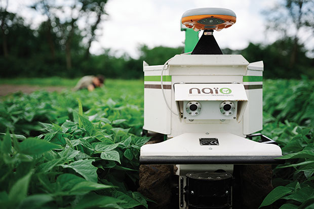
The DINO is a one-ton farming robot made by NAIO Technologies that operates autonomously using GNSS positioning and maps for navigation. Of the 170 NAIO farming robots currently in operation, about 30% are DINOs, which are typically used on large farms.
In 2016, NAIO and Septentrio, a manufacturer of industrial high-end GNSS technologies, began to research the integration of full GNSS solutions into NAIO’s robots.
Today, the DINO carries a Septentrio NR3, consisting of a GNSS receiver and antenna in a single housing, which provides it with RTK centimeter-level positioning accuracy. Farmers can use the NR3 to map their fields, then attach it to the DINO to guide it.
The DINO automates weeding within complex and quickly changing environments. NAIO plans to soon add seeding and fertilization to its robot’s capabilities.
To operate reliably in the narrow lanes between crops, the DINO requires an accurate GNSS receiver with strong resistance to multipath and jamming.
The safety of field hands and the protection of the crops also require the receiver to have good integrity, which is a measure of the trust that can be placed in the correctness of the information it supplies. Accuracy, robustness, and integrity are all strong suits of Septentrio’s NR3.
While the DINO mostly operates continuously, it sometimes stops to avoid animals or humans, or for other safety reasons. A major advantage of the NR3 and other sensors that NAIO is using, is that they enable the robot to perform cold-starts very rapidly and with a stable heading.
Machine control, guidance and automation defined
Using GNSS guidance to aid application of fertilizer, pesticides and herbicides saves time and money. (Photo: fotokostic/iStock/Getty Images Plus/Getty Images)
The terms machine control, machine guidance and machine automation are not interchangeable.
Machine control is a generic term that refers to the integration of positioning tools into a construction, mining or farming machine to determine its position on the Earth and relative to a desired design surface, mining task or cultivation technique.
Within machine control, machine guidancesystems display these data in the cab — assisting the machine’s operator in steering the machine and in maneuvering its implements to shape the ground, mine minerals, plant seeds or perform other related tasks — while machine automation systems directly steer the machine, achieving greater levels of precision than human operators could. The term automated machine guidance (AMG) is sometimes also used.
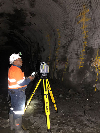
Trimble has introduced its SX12 Scanning Total Station, the next iteration of its 3D scanning total station that provides fast and efficient data capture for surveying, engineering and geospatial professionals.
New features include a high-power laser pointer and high-resolution camera system, expand capabilities in surveying, and complex 3D modeling. The SX12 enables enable new workflows in tunneling and underground mining, Trimble said.
The Trimble SX12 merges high-speed 3D laser scanning, Trimble VISION imaging technology and high-accuracy total station measurements into familiar field and office workflows for surveyors.
A new green, focusable Class 1M laser pointer — safe for viewing with the naked eye — offers high-power visibility and makes it easy to see at a distance. An improved camera system provides enhanced pointing and site documentation capabilities.
“The new SX12 adds more features and applications to an already widely adopted, field-proven scanning total station,” said Gregory Lepere, marketing director of Optical and Imaging for Trimble Geospatial. “The addition of a premium laser pointer completes the picture for surveyors wanting an instrument that can operate as an everyday high-end total station with the added value of scanning and imagery.”
Tunnels and underground mining
The Trimble SX12 allows users to quickly and easily operate with common survey workflows, including new versions of Trimble’s field and office software.
With Trimble Access 2021 Field Software, users can harness the full potential of the Trimble SX12, whether performing accurate measurements or comparing 3D scanning as-built data in the field. The combination is designed for infrastructure projects such as utilities, roads, rail, water, transportation and telecom.
The laser pointer enables new applications for laser-guided drilling and excavation guidance, rock bolt and blast hole set out, and as-built verification for underground tunnel and mine construction.
By integrating rich data from the Trimble SX12 into intuitive office workflows, Trimble Business Center version 5.40 enables users to quickly create complete customer deliverables. With its enhanced point-cloud management, eCogAI automated information extraction, and interoperability to leading CAD and GIS packages, the solution empowers users to exceed even the toughest client demands.
The combination also enables the capture of tunnel point clouds for as-built comparison, automated tunnel extraction routines and detailed 3D mesh inspection resulting in intuitive reporting deliverables for construction verification.
“Tunneling projects are highly dependent on accurate positioning to precisely control equipment and track progress in difficult underground construction environments,” said Boris Skopljak, marketing director of Monitoring and Tunneling for Trimble Geospatial. “The combination of the SX12 and new software workflows, simplifies the capture of site conditions, enabling tunneling and mining surveyors to make accurate and informed decisions without the complexity and additional cost of multiple systems.”