Surveying is both an ancient profession and one of today’s most technologically advanced. Surveyors are among the first on the site of a new construction project, staking out its corners and boundaries, and mapping elevation contours, as well as among the last, surveying the project “as built.” This is particularly important for features that will no longer be visible once the project is complete, such as underground utilities.
While many surveyors work in quiet, uncrowded environments — such as surveying the boundaries of farm fields — those who work on large construction projects operate among the hustle and bustle of bricklayers, carpenters, electricians, plumbers and other tradespeople, as well as cranes, backhoes and other heavy machines. This chaotic environment means that in addition to accuracy and efficiency, surveyors also are concerned with safety.
In the following cover story, a Minnesota-based construction company describes a new system it developed for surveying and mapping underground utilities. Also, professional surveyor Gavin Schrock discusses the benefits of a flexible approach to GNSS rover accuracy and of adding scanning capabilities to robotic total stations.
The danger of hitting a buried water or gas pipe when digging for a construction project persists despite many efforts to reduce it, such as “call before you dig” phone numbers. For example, in Minnesota there were 4,000 such hits in 2019. That is one reason why it is very important to map “as built” underground utilities accurately. This must be done quickly and efficiently, before trenches are filled and without slowing progress of the project.
Traditionally, crews have mapped the underground pipes and cables on paper. In turn, when a construction project needs to know the location of underground utilities before digging, it typically relies on someone who consults those paper maps, uses an electromagnetic utility locating tool, and marks the ground with spray paint. The construction crew then must correctly interpret those marks on the ground. In 2019, Minnesota-based utility consultancy Ellingson Companies was asked to develop a new and more efficient process.
Capturing Data in Real Time
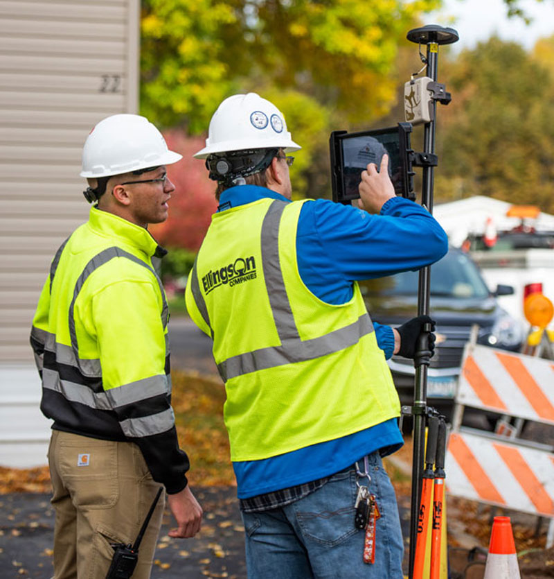
By leveraging solutions from Esri and from Canadian hardware and software manufacturer Eos Positioning Systems, Ellingson Companies GIS Manager Damon Nelton developed a solution that allows his team to capture new pipe construction in real time. By streamlining documentation workflows, the new process improved field productivity and allowed Ellingson Companies to produce digital as-builts that meet the needs of its gas utility clients and improve the safety of future construction projects.
While construction crews have been putting pipe in the ground for generations, today they are expected to produce a digital record of their work in real time — for the sake of safety and efficiency.
Using Esri’s Utility Pipeline Data Model, Nelton created a system that enables crews to map their as-built pipe projects while also tracking components. The system improves data integrity — in other words, reduces human error — by relying on scannable 16-digit alphanumeric bar codes developed by the American Society for Testing and Materials that provide seven attributes for each conduit, including thickness, diameter, lot number and manufacturer date. To collect and store these data, Nelton set up an ArcGIS Enterprise geodatabase.
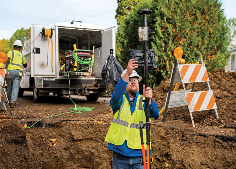
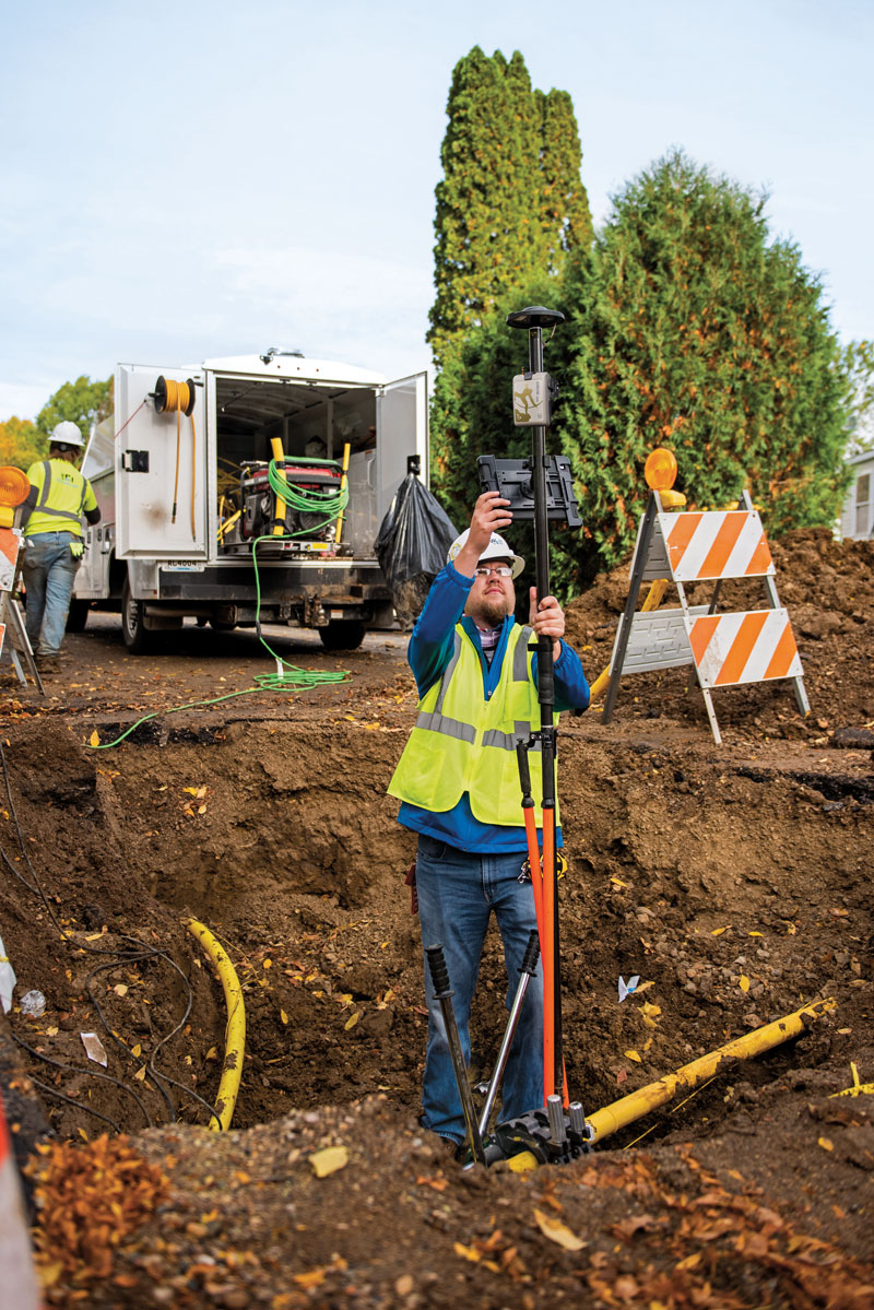
Gas meters, which also need to be mapped, are often in locations that are hard to map directly with a GNSS receiver because line-of-sight to the satellites is obstructed by trees, roof eves, or adjacent buildings. Therefore, they must be shot with an offset. For these situations, Nelton used Eos Positioning Systems’ laser mapping solution, which enables surveyors to use lasers attached to their range poles to feed data directly into their GIS.
No More Battleship
Using Eos Positioning System’s Arrow Gold receiver and the MNCoors RTK network, Nelton said, his team was able to average an accuracy of 0.25 throughout a project in the city of Owatonna, Minnesota, as confirmed by spot checks with other survey equipment and with the city’s survey team.
“Not every shot was easy, and some took multiple attempts and tricks of the trade to get them,” Nelton pointed out.
On projects in the middle of mountains, where real-time kinematic (RTK) networks do not exist, the company has used the Atlas Service, averaging accuracies of 12 in.
“Given the circumstances of these projects,” Nelton said, “we still consider that to be great.”
Using the new system, foremen use a survey in ArcGIS Survey123 to input their inspection notes and other information, feeding it all from the field to the office and into layers shared between divisions. This way, the data are available in real time, not at the end of the project.
For customers who still want a piece of paper to file in a physical folder in a filing cabinet, Nelton creates a Microsoft Word document template in their format, populates it using dynamic text with syntax in ArcGIS Pro, inserts a map, then saves the Word document as a PDF.
“At the end of the project, we got almost 17,000 digits with no human entry other than pressing the button on the barcode scanner, which means zero data errors,” said Nelton.
No pieces of paper with critical data on the underground utilities languish in a glove compartment or are eaten by a surveyor’s dog, and all the data is available in real time.
Additionally, the combination of the barcode scanning workflow and the high accuracy GNSS receiver enables Nelton’s team to locate gas asset pieces that need to be replaced — for example, due to a recall by the manufacturer — “without playing battleship,” he said.
“Addresses are created by local address authorities in city, county, and tribal agencies,” explained NSGIC Executive Director Molly Schar. “The data support delivery of services like utilities and emergency response, so getting it right is absolutely critical. NSGIC advocates the process of rolling up local address point records to the state to aggregate and then to the national level to save lives, reduce costs, avoid duplication, increase revenues, improve service and foster efficient and effective government.”
The roll-up process is at the heart of an effort led by the U.S. Department of Transportation and supported by NSGIC to develop a National Address Database. Only 23 states have provided statewide address data to the national database, with five states providing partial data, and three states in the queue.
For this publication, NSGIC tapped state geospatial information officers in Kansas, Massachusetts, Minnesota, New Mexico, New York, Utah and Vermont to identify key factors to the successful organization and coordination necessary to create and maintain strong address programs. These honor roll states scored in the top of the country in the area of address data in NSGIC’s 2019 Geospatial Maturity Assessment (GMA).
NSGIC recently finalized an interactive GMA geospatial web map application with dashboards customized for each data theme allows users to take a deeper dive into the 2019 results, interacting with individual state and collective national results to bring to life the visual patterns and trends in the data.
Geospatial data dashboards have become much more familiar to the public in recent months as most states and municipalities have adopted the interactive platforms to transparently display coronavirus information.
Launched in 2009 to document geospatial development practices and uses, the GMA has provided a biennial snapshot of each state’s geospatial maturity. Inspired by the National Spatial Data Infrastructure theme grading undertaken by the Coalition of Geospatial Organizations (of which NSGIC is a founding member), an entirely new process was developed for the 2019 GMA.
Nine-grade “report cards” were produced for individual state spatial data infrastructures and state geospatial coordination, in addition to overall theme and topical analysis.
Over the next 18 months, additional focused guidance will be issued in the areas of overall statewide coordination and the key datasets for next generation 9-1-1, transportation, parcels, hydrography, elevation, and orthoimagery.
“Collaboration, transparency, and increased efficiency in government are hallmarks of mature state GIS programs,” Schar said. “Through the Geospatial Maturity Assessment research and products, NSGIC is helping states set goals, identify opportunities for collaboration, shine a light on areas requiring attention, and build resources.”


 A report issued by the