Tag: mobile scanning

  • Emesent offers SLAM, lidar, RTK and 360° imagery mobile scanner

    Emesent offers SLAM, lidar, RTK and 360° imagery mobile scanner

    Emesent has launched its GX1 all-in-one mobile scanning system at Geo Week 2026 in Denver.

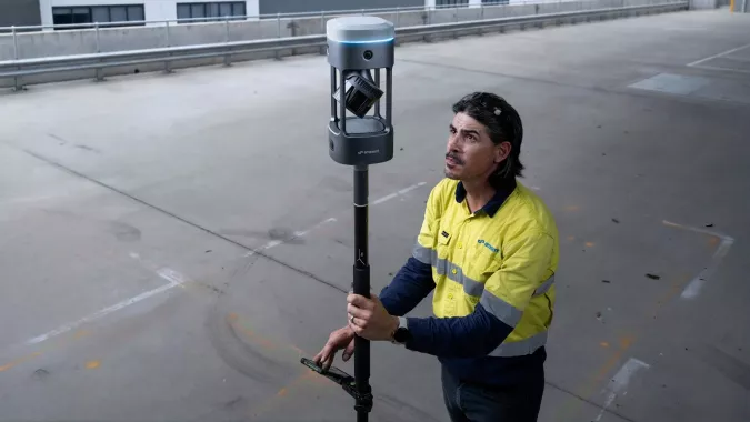
    The GX1 is an integrated, highly accurate all-in-one mobile scanning system combining simultaneous localization and mapping (SLAM), lidar, real-time kinematic (RTK) georeferencing, cameras and software. The product marks a breakthrough for the autonomous mapping technology company.

    The GX1 supports a seamless workflow, from capture to validated deliverable. It not only brings Emesent’s proven SLAM technology to everyday surveying applications, but also eliminates the longstanding trade-off faced by survey firms and players in the architecture, engineering and construction (AEC) industry between mobile scanning speed and dependable survey-grade accuracy.

    According to Emesent, the GX1 can reduce the time required to survey a site by up to 95%, reducing what once took weeks into a single day of scanning. Meanwhile, the independently validated global accuracy of 5-10 mm delivers the precision needed for use cases across topographic and road surveying, scan to building information models, construction progress tracking and more.

    These capabilities are supported by integrated RTK georeferencing with real-time quality monitoring, four 20MP cameras for 360° panoramic imagery, and Emesent’s proven SLAM algorithm. This technology — which also powers the Emesent Hovermap product — was developed and validated in extreme real-world environments, including GPS-denied, underground locations to ensure repeatable accuracy and reliability both indoors and out. Accuracy validation reports are produced quickly and easily in the Aura processing software.

    With four purpose-built deployment modes — backpack, survey pole, vehicle mount and supported handheld — and integrated batteries for cable-free management, the GX1 offers a high degree of versatility. In addition, surveyors can capture data using RTK in the field or using ground control points and checkpoints in post-processing. This flexible georeferencing minimizes the risk of having to return to a site for redo.

    “With the introduction of the GX1, we’ve answered the call we’ve heard echoing throughout the surveying industry to end the tug-of-war between fast and accurate,” said Dr Stefan Hrabar, chief strategy officer and co-founder of Emesent. “By putting the power of SLAM into the hands of the everyday surveyor, the GX1 raises the bar for mobile scanning accuracy and keeps critical projects on track.”

    The launch of the GX1 comes at a pivotal moment for survey firms and the AEC industry. They are grappling with a shortage of experienced surveyors, while also facing mounting pressure from clients demanding faster, cheaper and better results without compromising on quality. The GX1 has been designed to be simple enough for junior surveyors to train on and deploy in a matter of days. At the same time, it is powerful enough to meet — and, according to Emesent, exceed — the real-world needs of professionals in the field.

  • Why GNSS is the glue for construction

    Why GNSS is the glue for construction


    GNSS links the three steps in this example paving system. The mobile scanning system creates a 3D model that the grinding and paving equipment systems use. (Image: Topcon)
    GNSS links the three steps in this example paving system. The mobile scanning system creates a 3D model that the grinding and paving equipment systems use. (Image: Topcon)

    Even construction projects that involve separate pieces of heavy equipment can be tightly coupled, with GNSS as the “glue.” One example is Topcon’s SmoothRide paving system. The separate active steps of grinding and paving are working from a 3D model developed in a first step: precise mobile scanning. Each step constrains (horizontally) with GNSS, and vertically to the corresponding position in the model. In this example, the premium is on the quality of the scan.

    For the first step, an RD-M1 scanner, usually attached to a pickup truck, can scan at highway speeds. The positioning component is an integrated HiPer SR GNSS receiver and inertial measurement unit (IMU). The GNSS observations, IMU data, and velocity from a wheel encoder are post-processed (PPK) together, to provide a high-definition 3D model with very tight relative integrity.

    “A great lateral benefit of scanning in this manner is that it can be done quickly and also gives you a model of the area surrounding the road,” said Mark Larranaga, director, Intelligent Paving Business Development. “You get the terrain for drainage design, guardrails, signs, road furniture — everything you might need for good roadway design.”

    For base data for the post-processing, Larranaga said a GNSS base typically will be set up on the site, though if a permanent base from a network such as TopNet is nearby, that can be used.

    “The model is then created in MAGNET Collage software,” Larranaga said. “That produces the surface file. Once we get that created, we take it into a software called MAGNET Resurfacing. It is used to design for cross slope correction, or a smoothness factor, as well as material management  — the software will do all this automatically. The software empowers the customer to create a file for the machine that will maximize the potential of the end results, based on the project parameters. Thus, allowing the contractor to evaluate and learn about potential pitfalls and maximizing incentives.”

    The next step, using roadway surface grinding equipment, employs a two-antenna GNSS system (for position and heading). A sonic sensor is keyed to the corresponding elevations in the 3D model and informs the depth for which the grinder is set. The third step, paving, is quite similar: GNSS and a sonic sensor constrained by the precise 3D model. There are some implementations that add thermal cameras and look behind a paving machine to see whether certain target specifications are met in real time.

    Read more of this cover story, “Guide, Assist, Automate: Why GNSS remains a key element for most applications.”

  • Faro acquires mobile scanning company GeoSLAM

    Faro acquires mobile scanning company GeoSLAM

    Image: Faro
    Image: Faro

    Faro Technologies Inc., a 4D digital reality company, has acquired GeoSLAM.

    Founded in 2012, GeoSLAM is a provider of mobile scanning solutions with proprietary high-productivity simultaneous localization and mapping (SLAM) software to create 3D models for use in digital twin applications.

    The addition of GeoSLAM is expected to significantly expand and accelerate Faro’s market growth in the mobile scanning space.

    “We are thrilled to add GeoSLAM’s handheld 3D scanning technology to our portfolio of cutting-edge data capture solutions,” said Michael Burger, Faro president and CEO. “Faro now offers the industry’s broadest set of 4D data-capture solutions, including 360° camera-based images, mobile scanning and stationary high-accuracy laser scanning, allowing customers to balance the need for accuracy, speed and detail depending on their requirements. These capture technologies provide the foundation for our 4D digital-reality-based SaaS (software-as-a-service) offering that will allow customers to access multiple 4D data sources for visualization and analysis through a single user experience. We welcome the GeoSLAM team to our Faro family.”

    “Joining with Faro represents the next step in the growth of GeoSLAM and the establishment of mobile mapping as a driver for growth in the way businesses map and understand their spaces,” said Andy Parr, GeoSLAM CEO. “Both companies share a vision of the importance of mobile scanning in the burgeoning digital reality capture market.”

    GeoSLAM reported £14.5 million in revenue with 18% EBITDA in the fiscal year ending March 31, 2022. EBITDA, a non-GAAP measure, is calculated as net income/loss before interest (income) expense, net, income tax expense (benefit), foreign exchange rate variance, and depreciation and amortization. The transaction closed on Sept. 1, funded with available cash reserves and equity consideration.

    Under terms of the agreement, GeoSLAM shareholders received a cash payment of £22.0 million and 495,562 shares of Faro stock subject to customary lock-up provisions. Faro expects the acquisition to be accretive to Non-GAAP EPS in 2023.

    Faro serves the markets of architecture, engineering and construction (AEC); facility operations and maintenance; 3D metrology; and public safety analytics.