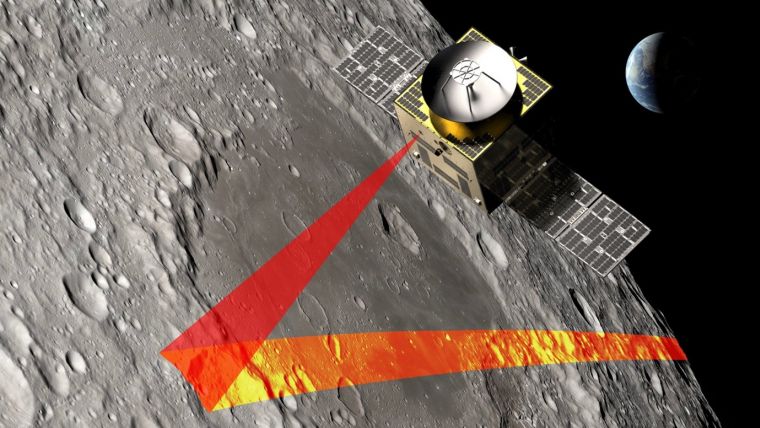
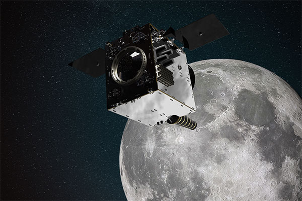
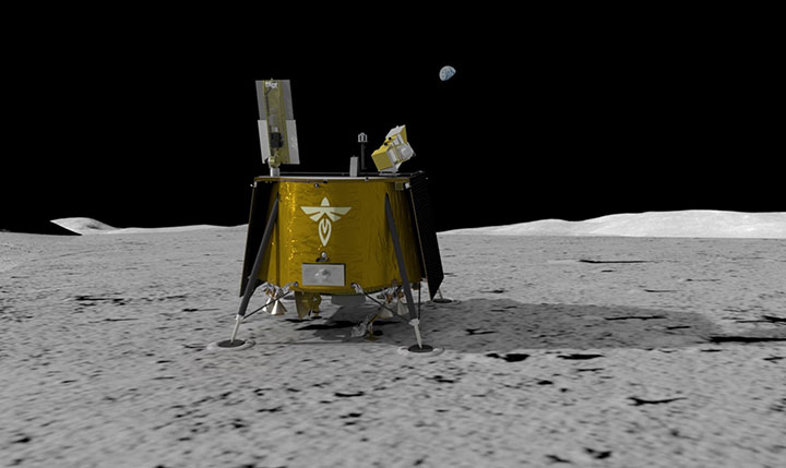
SFL Missions joins a team led by NUVIEW GmbH, which the European Space Agency has contracted to conduct a Pre-Phase A study for the Moonraker lunar mapping mission. This study launches under a new initiative for Small Exploration Missions. The Moonraker satellite will carry a laser scanner to create a detailed elevation map of the Moon’s surface.
The Moonraker mission will deploy a single orbiter in a low-altitude polar orbit around the Moon. The orbiter will host a lidar payload to capture highly accurate elevation points of the terrain. The team will use these data points to generate three-dimensional elevation models, which will guide the assessment and selection of future lunar landing sites.
Moonraker’s lidar data also seeks to advance broader scientific research. The mission will scan permanently shadowed regions to search for water ice and provide new insights into the Moon’s geology and internal composition. The Moonaker lidar will operate in two modes: one for broad-area scanning of the lunar polar regions and another for high-resolution surveys of specific areas of interest.
SFL Missions shared in a statement that Mission analysts are evaluating potential launch options and trajectories to efficiently enter lunar orbit. They are also studying how operational orbit parameters affect spacecraft design and payload data collection. The system design team focuses on accommodating the payload, configuring the spacecraft layout, and sizing subsystem components. They are designing the propulsion system to carry enough fuel for the transit phase and to maintain the operational orbit, compensating for disturbances from the Moon’s irregular gravity field. The team is developing detailed mission and system requirements to guide future design phases.
NUVIEW GmbH, based in Berlin, leads the Pre-Phase A study team, which includes several partners alongside SFL Missions. NUVIEW GmbH, a wholly owned subsidiary of NUVIEW Inc., is developing the world’s first commercial space-based LiDAR constellation for three-dimensional mapping of Earth.
SpacePNT and European Engineering and Consultancy (EECL) have completed the final presentation of the European Space Agency (ESA)-funded Earth Moon GNSS Spaceborne Receiver for In-Orbit Demonstration project. This project aimed to develop and qualify the NaviMoon GNSS spaceborne receiver for lunar applications.
Currently, geostationary orbit (GEO) and geostationary transfer orbit (GTO) missions utilize GNSS signals for in-orbit positioning, navigation and timing (PNT). NASA’s Magnetospheric Multiscale (MMS) mission has shown that GPS signal tracking is possible up to 150,000 km from Earth’s surface, which is half the distance to the Moon. ESA has assessed the feasibility of extending GNSS use for lunar missions through studies under its General Studies Program (GSP). These studies indicate that lunar navigation using GNSS might be feasible if specific high-sensitivity techniques are implemented in GNSS spaceborne receivers.
NaviMoon is an advanced version of SpacePNT’s spaceborne GNSS receiver NaviLEO. It supports dual constellation (GPS and Galileo) and dual frequency (E1/L1 and E5a/L5) operation. The receiver is based on commercial off-the-shelf (COTS) components with radiation mitigation measures. It features fast digital signal processing in hardware and handles acquisition, tracking control and navigation in software. NaviMoon also includes a dedicated microcontroller for interface management and can be reprogrammed in flight.
EECL contributed to the project by providing the GNSS reflectometry front end for remote sensing. The company developed the lunar low-noise amplifier (LNA), which is crucial for detecting ultra-weak signals at lunar distances.
The NaviMoon project involved comprehensive testing, including mechanical tests, thermal vacuum tests, electromagnetic compatibility testing and a full GNSS test campaign. The presentation shared that it is a robust platform with high radiation tolerance and environmental performance. It aims to deliver less than 100 m accuracy at Moon distance while reducing dependence on costly Earth infrastructure for orbit determination.
This project was funded under ESA’s NAVISP program, which is dedicated to European industrial technology innovation in the PNT sector. It also received support from ESA’s GNSS Science Advisory Committee (GSAC).
Collaboration powers GPS and Galileo navigation experiment
By Danny Baird NASA’s Goddard Space Flight Center
As the Artemis missions journey to the Moon and NASA plans for the long voyage to Mars, new navigation capabilities will be key to science, discovery and human exploration.
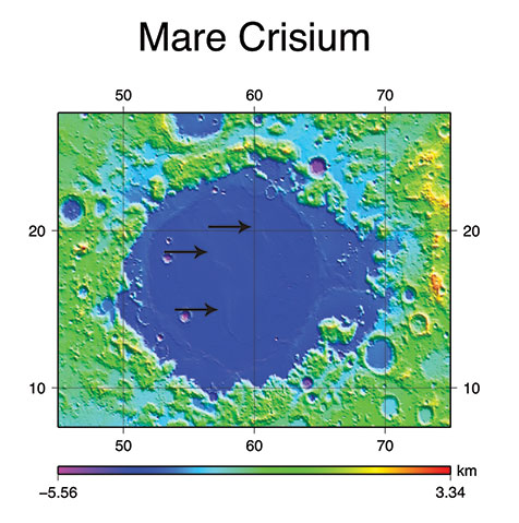
Through NASA’s Commercial Lunar Payload Services initiative, Firefly Aerospace of Cedar Park, Texas, will deliver an experimental payload to the Moon’s Mare Crisium basin. NASA’s Lunar GNSS Receiver Experiment (LuGRE) payload will test a powerful new lunar navigation capability using Earth’s GNSS signals at the Moon for the first time.
“In this case, we are pushing the envelope of what GNSS was intended to do — that is, expanding the reach of systems built to provide services to terrestrial, aviation, and maritime users to also include the fast growing space sector,” said J.J. Miller, deputy director of Policy and Strategic Communications for NASA’s Space Communications and Navigation (SCaN) program. “This will vastly improve the precision and resilience of what was available during the Apollo missions, and allow for more flexible equipage and operational scenarios.”
LuGRE — developed in partnership with the Italian Space Agency (ASI) – will receive signals from both GPS and Galileo, and use them to calculate the first-ever GNSS location fixes in transit to the Moon and on the lunar surface.
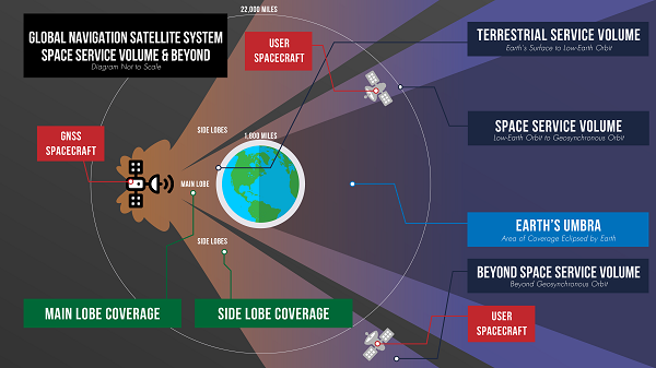
“Space missions close to Earth have long relied on GNSS for their navigation and timekeeping,” said Joel Parker, LuGRE principal investigator at NASA’s Goddard Space Flight Center in Greenbelt, Maryland. “In recent years, NASA and the international community have pushed the boundaries of what was considered possible by using these techniques in the Space Service Volume and beyond.”
This graphic details the different areas of GNSS coverage. (Image: NASA/Danny Baird)
Missions in the GNSS Space Service Volume — from about 1,800 miles to 22,000 miles in altitude — receive signals that spill past Earth’s edge from GNSS satellites on the opposite side of the planet. The first Space Service Volume experiments occurred around the dawn of the new millennium. Since then, numerous missions in the Space Service Volume have reliably used GNSS to navigate.
In 2016, the NASA’s Magnetospheric Multiscale Mission (MMS) employed GPS operationally at a record-breaking 43,500 miles from Earth. Then, in 2019, MMS broke its own record by fixing its location with GPS at 116,300 miles from Earth — nearly halfway to the Moon.
At these extreme altitudes, missions need extremely sensitive GNSS receivers. The LuGRE mission will use a specialized weak-signal receiver developed by Qascom, an Italian company specializing in space cybersecurity and satellite navigation security solutions, and funded by ASI.
LuGRE teams are now testing the payload in preparation to deliver it for integration onto the Firefly “Blue Ghost” lander in November of this year. Launch is slated for no earlier than 2024 from Cape Canaveral, Florida, aboard a SpaceX Falcon 9 rocket.
During the multi-week flight to the Moon, LuGRE will collect GNSS signals and perform navigation experiments at different altitudes and in lunar orbit. After landing, LuGRE will deploy its antenna and begin 12 days of data collection, with the potential for extended mission operations. NASA and ASI will process and analyze data downlinked to Earth, and then share results publicly.
“LuGRE is the latest effort in a long line of missions designed to expand high-altitude GNSS capabilities,” said Fabio Dovis, LuGRE co-principal investigator, ASI. “We’ve developed a cutting-edge experiment that will serve as the foundation for operational GNSS systems at the Moon.”
The LuGRE mission seeks to spark further development of GNSS-based navigation capabilities near and on the Moon, even as NASA plans to begin using high-altitude GNSS operationally for future lunar missions. NASA and ASI will bring the results of this work forward to the space community through the International Committee on GNSS, a United Nations forum focused on ensuring the interoperability of GNSS signals. These capabilities are also a key stepping stone towards building LunaNet, an architecture that will unify cooperative networks into seamless lunar communications and navigation services.
Artistic rendering of LuGRE and the GNSS constellations. In reality, the Earth-based GNSS constellations take up less than 10 degrees in the sky, as seen from the Moon. (Image: NASA/Dave Ryan)
“The lunar deliveries we’re sourcing from commercial vendors are providing a number of innovative new technologies and opportunities to conduct experiments with affordable access to the lunar surface,” said Jay Jenkins, Commercial Lunar Payload Services Program executive. “LuGRE is one example of the progress that government and industry can make when united in their exploration objectives.”
Developing new uses of GNSS for emerging space operations is a priority for the SCaN program at NASA headquarters, as the lead organization responsible for implementing guidance from Space Policy Directive-7, which directs NASA to develop requirements for GPS support of space operations and science in higher orbits and beyond into cislunar space.
Artist’s impression of SSTL’s Lunar Pathfinder satellite that will provide communications services around the Moon. (Image: SSTL)
News from the European Space Agency (ESA)
ESA is going to the Moon — in collaboration with its international partners — and seeks to build a lasting lunar link to enable sustainable space exploration.
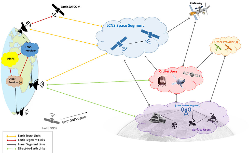
The agency has now evaluated initial ideas to create a network of lunar telecommunications and navigation satellites.
Creating a commercial telecommunications and navigation service for the Moon will allow many of the dozens of planned lunar missions to share the same infrastructure to communicate with Earth, as well as to find their way on the lunar surface.
The service is needed because the planned missions are becoming regular trips to Earth’s natural satellite rather than one-off expeditions.
Using a shared telecommunications and navigation service will reduce the design complexity and weight of individual missions, making them more cost-efficient.
Lowering the ticket price to lunar exploration could also empower a wider group of ESA member states to launch their own national lunar missions, inspiring the next generation of scientists and engineers.
Call for Ideas
The call for ideas for how to use a lasting link with the Moon is open until April 30. People working for commercial companies, universities or governmental organizations are welcome to suggest how they would like to use a lunar communications and navigation service.
This diagram presents a notional preliminary top-level system concept for a lunar communications and navigation service. (Image: ESA)
Concept Reviews Completed
Two consortia of companies have now completed their system concept reviews, which set out how to create the lunar constellation, under ESA’s Moonlight initiative to identify the best way to create a lasting link with the Moon. The reviews set out the business and technical analysis needed to identify and justify a number of feasible system concepts for creating the lunar network.
The next step will be to define a detailed system architecture and identify the most suitable partnership models between private space companies and ESA.
Telespazio leads the first consortium. The consortium includes:
satellite operators Inmarsat and Hispasat
manufacturing companies such as Thales Alenia Space Italy, OHB System in Germany and Canadian space technology company MDA
Italian Aerospace Logistics Technology Engineering Company (ALTEC)
small and medium-sized enterprises such as Nanoracks Europe and Argotec
universities and research centers such as SEE Lab, SDA Bocconi and Politecnico di Milano.
The second consortium is spearheaded by Surrey Satellite Technology Limited, both in the service prime capacity through its lunar services brand SSTL Lunar and as the satellite manufacturer. The consortium includes:
satellite manufacturer Airbus
satellite network providers SES, based in Luxembourg, and Kongsberg Satellite Services, based in Norway
the Goonhilly Earth Station in the UK
British satellite navigation company GMV-NSL.
Artemis Program and Pathfinder
NASA’s Artemis program will use several of ESA’s service modules to return humans to the Moon, including the ESPRIT communications module for the lunar Gateway’s living quarters for astronauts. With its European industrial partner, ESA is helping to build the Lunar Pathfinder, showcasing lunar communications service provision by providing initial services to early lunar missions, including a complete lunar navigation in-orbit demonstration.
The Moonlight initiative builds on both the ESPRIT communications module and the Lunar Pathfinder.
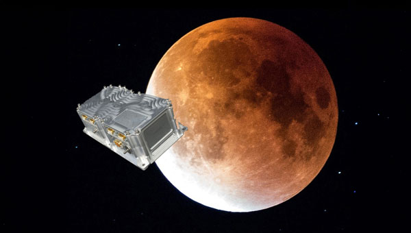
A GNSS receiver is scheduled to land on the Moon in 2023, sent by NASA and the Italian Space Agency (ASI). The innovative GPS and Galileo receiver, provided by Qascom, will experiment with satellite-based positioning on the lunar surface.
The project, dubbed NEIL (Navigation Early Investigation on Lunar surface), is at the center of an agreement between ASI and NASA, linked to the CLPS 19-D mission (NASA’s Commercial Lunar Payload Service, Task Order 19).
The NEIL payload will be integrated into the Lunar GNSS Receiver Experiment (LuGRE), an ASI/NASA cooperation framework to develop activities in lunar and cislunar environments.
For the first time in history, GNSS positioning will be tested at almost 400,000 kilometers from Earth. The previous limit was a distance of 200,000 kilometers, tested in the Magnetospheric Multiscale (MMS) project.
NEIL will be integrated on the NASA’s Blue Ghost lunar lander in 2022. In addition to the NEIL payload, nine other experiments will land on the Moon. The mission is expected to be launched via a SpaceX Falcon 9, and the lander with aim for the Mare Crisium basin.
Image: NASA/Resse Patillo
Moon-Hardened Receiver
Under an ASI contract, Qascom will develop the dual-frequency GPS and Galileo receiver, as well as the entire radiofrequency chain (antenna, LNA, filters), all of which can withstand the extreme environmental conditions of the Moon.
The GPS and Galileo signals received from NEIL will be extremely weak due to the distance from Earth, and will be processed with specific algorithms allowing to calculate position and time, even if with reduced accuracy, both during the Moon transfer orbit and on its surface.
Image: NASA
“This experiment is of strategic importance for Italy, since it will bring our technology to the Moon surface,” stated the Italian Space Agency. “It contributes to strengthening the competitiveness of the Italian space sector and consolidates the strong collaboration between the Italian Space Agency and NASA in the satellite navigation segment as well as in the future Moon and Mars missions.”
NEIL provides also an important technical and scientific contribution to study how GPS and Galileo could be used for positioning and timing in future Moon missions, including for example the deployment of lunar satellite constellations, lunar rovers, the lunar space station Gateway and the infrastructures that are going to be developed in the frame of Artemis programs. The raw measurement collected will be used by the research community to study the lunar and cislunar environment and evaluate the future use of GNSS to support permanent missions.
PNT beacons can be deployed in orbit to penetrate the lunar surface and enable consistent wireless connectivity. (Image: Masten Space Systems)
Masten Space Systems has been awarded a U.S. Air Force contract to develop and demonstrate a lunar positioning and navigation network prototype that functions much like GPS.
The Phase II Small Business Innovation Research (SBIR) contract was awarded through the Air Force Research Laboratory’s AFWERX program. AFWERX connects innovators across government, industry and academia.
The navigation network will enhance cislunar security and awareness by enabling navigation and location tracking for spacecraft, assets, objects and astronauts on the lunar surface or in lunar orbit. As the lunar infrastructure grows, the network will help advance lunar science and resource use by improving landing accuracy and hazard avoidance near critical lunar sites.
“Unlike Earth, the Moon isn’t equipped with GPS so lunar spacecraft and orbital assets are essentially operating in the dark,” said Matthew Kuhns, vice president of research and development at Masten. “As a result, each spacecraft is required to carry heavy navigation hardware and sensors on-board to estimate positioning and detect potential hazards. By establishing a shared navigation network on the Moon, we can lower spacecraft costs by millions of dollars, increase payload capacity, and improve landing accuracy near the most resource-rich sites on the Moon.”
In Phase I, Masten completed the concept design for the network prototype that offloads positioning, navigation, and timing (PNT) beacons from a spacecraft into a dedicated sensor array on the Moon.
In Phase II of the project, scheduled to be complete in 2023, Masten will develop PNT beacons equipped to survive harsh lunar conditions. Masten is collaborating with Leidos to build shock-proof beacon enclosures that can be deployed in lunar orbit to penetrate the lunar surface and create an autonomous surface-based network. Similar to a mesh network, the surface-based network can enable consistent wireless connectivity to lunar spacecraft, objects, and orbital assets.
“Leidos is proud to collaborate with Masten Space Systems in their quest toward a successful lunar surface-based positioning and navigation network,” said Thomas Sereno, vice president and division manager of the Applied Science operation at Leidos. “We are prepared to support the team as they progress through the next phase of the contract.”
In Phase II of the project, the PNT technology will also be tested aboard Masten’s rocket-powered lander, Xodiac, to demonstrate payload integration and beacon operations in a terrestrial environment, enabling a path towards lunar demonstration.
Masten has more than a decade of experience maturing PNT systems, including Jet Propulsion Laboratory’s lander vision system that was tested on Masten’s Xombie rocket to enable a successful Mars mission for the NASA Perseverance rover.
“As one of the first commercial companies sending a lunar lander to the Moon, we’re in a unique position to develop and deploy a shared navigation system that can support other government and commercial missions and enable a thriving lunar ecosystem,” said Masten CEO Sean Mahoney. “We are literally blazing the trail with this effort, creating the pathway for regular, ongoing and reliable access to the Moon.”
Swiss company SpacePNT will develop an advanced spaceborne GPS/Galileo receiver to demonstrate for lunar navigation and positioning.
A vision of the NAVIMOON receiver. (Image: SpacePNT)
The European Space Agency (ESA) has selected SpacePNT to develop an advanced spaceborne GPS/Galileo receiver to demonstrate the use of terrestrial satellite navigation signals or real-time and autonomous orbit determination and positioning, navigation and timing (PNT).
The receiver will be carried aboard the ESA-SSTL Lunar Pathfinder spacecraft, which will be placed in orbit around the Moon.
The contract includes the development, qualification and delivery of one proto-flight model (PFM) and two engineering models of the NAVIMOON receiver. NAVIMOON is the high-sensitivity version of SpacePNT’s NAVILEO high-performance GNSS spaceborne receiver.
The NAVIMOON receiver implements high-sensitivity algorithms able to receive and process signals extremely attenuated coming from the spillover (side lobes) around the Earth of signals transmitted by satellite navigation systems. It combines these signals’ measurements with advanced on-board orbital filters to achieve onboard the spacecraft in real time an unprecedented target orbit determination accuracy of 100 meters root-mean-square (rms) at Moon altitude, which is well above the typical accuracy that can be achieved with terrestrial radio ranging that involves the use of costly deep-space-station ground infrastructures.
Given the high interest in Moon exploration and colonization (more than 50 commercial and governmental missions have been announced between now and 2024), it is expected that this NAVIMOON receiver technology will play a significant role in the next decade not only on Earth-Moon transfer orbits, but also to provide enhanced PNT services for users on the Moon. Deployment of a lunar constellation will allow the provision of lunar navigation in Moon-obstructed areas.
For this project, SpacePNT will partner with EECL from the UK. EECL will work as a subcontractor and bring significant space expertise to the electronics design, manufacturing and qualification of the receiver.
Space communications and navigation engineers at NASA are evaluating the navigation needs for the Artemis program, including identifying the precision navigation capabilities needed to establish the first sustained presence on the lunar surface.
“Artemis engages us to apply creative navigation solutions, choosing the right combination of capabilities for each mission,” said Cheryl Gramling, associate chief for technology in the Mission Engineering and Systems Analysis Division at Goddard Space Flight Center in Greenbelt, Maryland. “NASA has a multitude of navigation tools at its disposal, and Goddard has a half-century of experience navigating space exploration missions in lunar orbit.”
Alongside proven navigation capabilities, NASA will use innovative navigation technologies during the upcoming Artemis missions.
“Lunar missions provide the opportunity to test and refine novel space navigation techniques,” said Ben Ashman, a navigation engineer at Goddard. “The Moon is a fascinating place to explore and can serve as a proving ground that expands our navigation toolkit for more distant destinations like Mars.”
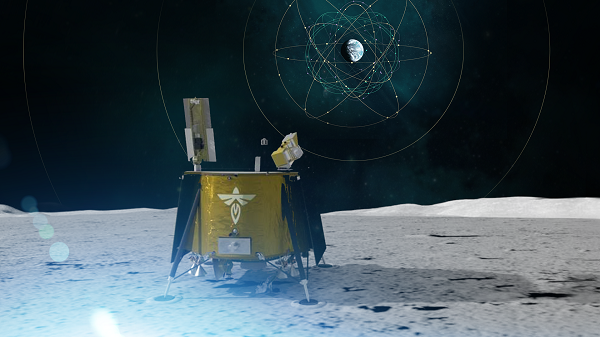
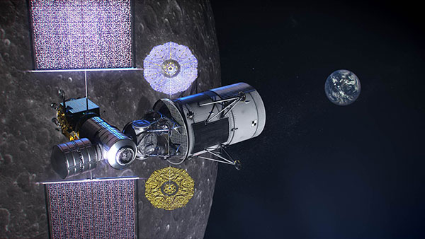
Illustration of NASA’s lunar-orbiting Gateway and a human landing system in orbit around the Moon. (Image: NASA)
Ultimately, exploration missions need a robust combination of capabilities to provide the availability, resiliency, and integrity required from an in-situ navigation system. Some of the navigation techniques being analyzed for Artemis include the following.
Radiometrics, optimetrics and laser altimetry
Radiometrics, optimetrics, and laser altimetry measure distances and velocity using the properties of electromagnetic transmissions. Engineers measure the time it takes for a transmission to reach a spacecraft and divide by the transmission’s rate of travel — the speed of light.
These accurate measurements have been the foundation of space navigation since the launch of the first satellite, giving an accurate and reliable measurement of the distance between the transmitter and spacecraft’s receiver. Simultaneously, the rate of change in the spacecraft’s velocity between the transmitter and spacecraft can be observed due to the Doppler effect.
Radiometrics and optimetrics measure the distances and velocity between a spacecraft and ground antennas or other spacecraft using their radio links and infrared optical communications links, respectively. In laser altimetry and space laser ranging, a spacecraft or ground telescope reflects lasers off the surface of a celestial body or a specially designated reflector to judge distances.
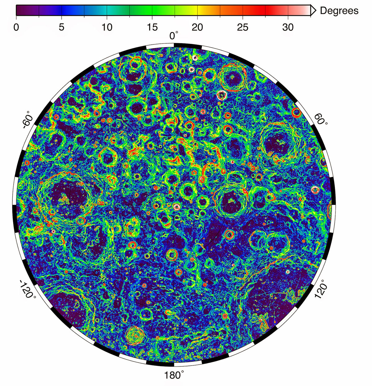
The Lunar Orbiter Laser Altimeter (LOLA) aboard the Lunar Reconnaissance Orbiter (LRO) sends laser pulses down to the surface of the Moon from the orbiting spacecraft. These pulses bounce off of the Moon and return to LRO, providing scientists with measurements of the distance from the spacecraft to the lunar surface. As LRO orbits the Moon, LOLA measures the shape of the lunar surface, which includes information about the Moon’s surface elevations and slopes. This image shows the slopes found near the South Pole of the Moon. (Image: NASA/LRO)
Optical navigation
Optical navigation techniques rely on images from cameras on a spacecraft. There are three main branches of optical navigation.
Star-based optical navigation uses bright celestial objects such as stars, moons, and planets for navigation. Instruments use these objects to determine a spacecrafts’ orientation and can define their distance from the objects using the angles between them.
As a spacecraft approaches a celestial body, the object begins to fill the field of view of the camera. Navigation engineers then derive a spacecraft’s distance from the body using its limb — the apparent edge of the body — and centroid, or geometric center.
At a spacecraft’s closest approach, Terrain Relative Navigation uses camera images and computer processing to identify known surface features and calculate a spacecraft’s course based on the location of those features in reference models or images.
NASA will use data gathered from LuGRE to refine operational lunar GNSS systems for future missions.
Weak-signal GPS and GNSS
NASA is developing capabilities that will allow missions at the Moon to leverage signals from GNSS constellations. These signals — already used on many Earth-orbiting spacecraft — will improve timing, enhance positioning accuracy, and assist autonomous navigation systems in cislunar and lunar space.
In 2023, the Lunar GNSS Receiver Experiment (LuGRE), developed in partnership with the Italian Space Agency, will demonstrate and refine this capability on the Moon’s Mare Crisium basin. LuGRE will fly on a Commercial Lunar Payload Services mission delivered by Firefly Aerospace of Cedar Park, Texas. NASA will use data gathered from LuGRE to refine operational lunar GNSS systems for future missions.
Illustration of Firefly Aerospace’s Blue Ghost lander on the lunar surface. The lander will carry a suite of 10 science investigations and technology demonstrations to the Moon in 2023 as part of NASA’s Commercial Lunar Payload Services (CLPS) initiative.
Autonomous navigation
Autonomous navigation software leverages measurements like radiometrics, celestial navigation, altimetry, terrain-relative navigation, and GNSS to perform navigation onboard without contact with operators or assets on Earth, enabling spacecraft to maneuver independently of terrestrial mission controllers. This level of autonomy enables responsiveness to the dynamic space environment.
Autonomous navigation can be particularly useful for deep space exploration, where the communications delay can hamper in-situ navigation. For example, missions at Mars must wait eight to 48 minutes for round trip communications with Earth depending on orbital dynamics. During critical maneuvers, spacecraft need the immediate decision-making that autonomous software can provide.
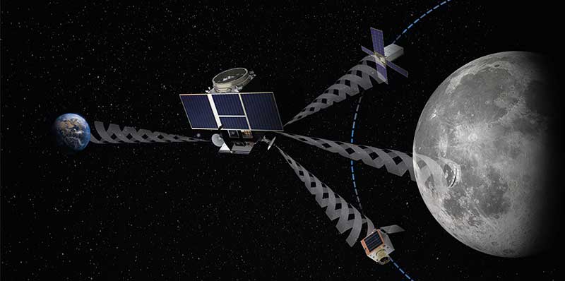
LunaNet navigation services
LunaNet is a unique communications and navigation architecture developed by NASA’s Space Communications and Navigation (SCaN) program. LunaNet’s common standards, protocols, and interface requirements will extend internetworking to the Moon, offering unprecedented flexibility and access to data.
For navigation, the LunaNet approach offers operational independence and increased precision by combining many of the methods above into a seamless architecture. LunaNet will provide missions with access to key measurements for precision navigation in lunar space.
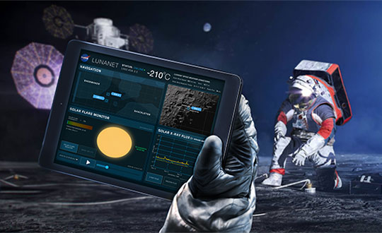
Artist’s conceptualization of Artemis astronauts using LunaNet services on the Moon, a unique approach to lunar communications and navigation. The LunaNet communications and navigation architecture will enable the precision navigation required for crewed missions to the Moon and place our astronauts closer to scientifically significant lunar sites, enhancing the our missions’ scientific output. (Image: NASA/Resse Patillo)
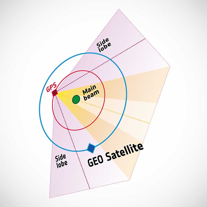
To pinpoint a location accurately, a receiver — in smartphones or on a spacecraft — needs to collect and combine signals from at least four navigation satellites. The receiver determines its distance from each of the satellites by measuring the time that it takes for the signal to travel from the satellite to the receiver.
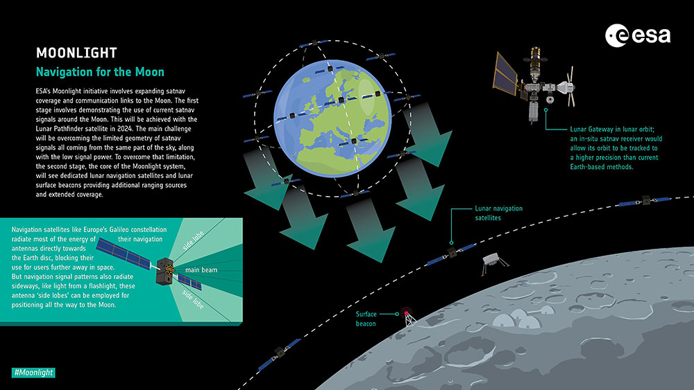
Navigation satellites aim their antennas directly at Earth. Satellites orbiting above the navigation (GPS in this image, but Europe’s own navigation system is Galileo) constellation could only hope to detect signals from Earth’s far side. Now spacecraft can make use of signals emitted sideways from navigation antennas, within what is known as “side lobes.” Just like a torch, they shine energy to the side as well as directly forward.
Navigation satellites orbit 22,000 kilometers above Earth’s surface. As they point in the direction of Earth, any spacecraft between them and Earth are served well by their signal. But around 10 years ago, engineers started demonstrating that spacecraft outside the orbit of navigation satellites could also navigate in space using “spill over” signal from the satellites.
Then in 2012, two discovery and preparation studies explored a seemingly radical question: could this spillover signal even be used to navigate our way around the moon, and if so, what kind of receiver would we need to build to be able to use these signals?
The studies found that the signal from navigation satellites orbiting Earth could be used to navigate the moon’s surface. But with the signal being so weak, they found that a new type of receiver would need to be built, and at the time there was no clear application for this.
Eight years later, ESA invested in the development of such a receiver, and is exploring whether it could be demonstrated on the Lunar Pathfinder mission. ESA is collaborating with Surrey Satellite Technology Ltd. and Goonhilly Earth Station on this mission, which will provide exciting new opportunities for science and technology demonstration. In particular, it will help lay the groundwork for providing navigation services around the moon, currently studied through two ESA NAVISP activities and culminating in the Moonlight initiative.
“We have now accurate simulation results that show that navigation signals may be used at moon orbit and provide good performances,” said Dr. Javier Ventura-Traveset, head of the Galileo Science Office and in charge of coordinating all GNSS moon activities for ESA’s Navigation Directorate. “And with an innovative receiver in Lunar Pathfinder, we could have the first ever experimental evidence of this.
Artist’s impression of the Lunar Pathfinder mission. (Image: SSTL)
“Furthermore, we are also studying how existing navigation constellations may be complemented by additional moon-orbiting satellites, providing additional ranging signals for an optimal navigation service including moon landing and moon surface operations. This is being done as part of the ESA NAVISP program and through the ESA Moonlight initiative.”
“The discovery and preparation studies have been eye-openers and they are currently being followed up by a NAVISP activity aiming to develop the highly sensitive spaceborne navigation receiver planned to fly on board Lunar Pathfinder,” said ESA Radio Navigation Engineer Pietro Giordano. “This technology will enable improved performances and much more cost-effective ways to navigate and operate missions to and around the moon.”