Tag: nationwide differential GPS

  • NDGPS to remain operational, fewer sites face decommissioning

    NDGPS to remain operational, fewer sites face decommissioning

    The United States Coast Guard, Department of Transportation and Army Corps of Engineers have issued a notice that reduces the number of Nationwide Differential Global Positioning System (NDGPS) sites that will be decommissioned.

    The agencies published a notice on Aug. 18, 2015, seeking public comments on the proposed shutdown and decommissioning of 62 the then-existing 84 NDGPS sites.

    “After a review of the comments received, we have reduced to 37 the number of NDGPS sites to be shut down, nine of which are USCG Maritime sites and 28 of which are DOT inland sites,” the notice reads. “As a result of this action, the NDGPS system will remain operational with a total of 46 USCG and USACE sites available to users in the maritime and coastal regions.”

    Over time, a number of factors have contributed to the declining public use of the NDGPS, including lack of a carriage requirement, technological advances in GPS and limited availability of consumer-grade DGPS receivers.

    The Federal Register Notice reduces the number of Differential GPS sites throughout the country, while maintaining coverage in major maritime ports and waterways.

    Read the full notice at the Federal Register website, including a list of sites to be decommissioned. Termination of the broadcast signal is scheduled to occur within the next 30 days.

    Graphic depicting NDGPS after site reductions. (U.S. Coast Guard)
    Graphic depicting NDGPS after site reductions. (U.S. Coast Guard)
    Graphic depicting NDGPS coverage after site reductions. (U.S. Coast Guard)
    Graphic depicting NDGPS coverage after site reductions. (U.S. Coast Guard)
    Original NDGPS coverage.
    Original NDGPS coverage.
  • US congressmen seek delay to NDGPS closings

    Four U.S. congressman sent a letter to the Department of Transportation asking the DoT to delay shutting down Nationwide Differential GPS (NDGPS) sites, a proposal that was posted in the Federal Register.

    The congressmen are asking for a delay until the “administration has decided upon and implemented a resilient national positioning, navigation and timing (PNT) architecture.”

    Read the full text of the letter below, or download the PDF.


  • Nationwide Differential GPS Shutdown Proposed, Comments Sought

    oceantides
    Twenty-two NDGPS sites that serve coastal areas would remain operational under the proposal.

    An Aug. 18 Federal Register notice proposes shutting down the Nationwide Differential Global Positioning System (NDGPS) in January 2016 because of a decline in its use, except for sites in coastal areas.

    The notice, issued by the U.S. Coast Guard (USCG), Transportation Department (DOT) and Corps of Engineers (USACE), reads:

    The Nationwide Differential Global Positioning System (NDGPS) service augments GPS by providing increased accuracy and integrity using land-based reference stations to transmit correction messages over radiobeacon frequencies. The service was implemented through agreements between multiple federal agencies including the  USCG, DOT, and Army Corps of Engineers, as well as several states and scientific organizations, all cooperating to provide the combined national DGPS utility.

    However, a number of factors have contributed to declining use of NDGPS and, based on an assessment by the Department of Homeland Security, DOT and USACE. DHS, DOT and USACE are proposing to shut down and decommission 62 DGPS sites, which will leave 22 operational sites available to users in coastal areas.

    A DGPS reference station antenna.
    A DGPS reference station antenna.

    Contributing factors cited in the decision are:

    • USCG changes in policy to allow aids to navigation (ATON) to be positioned with a GPS receiver using Receiver Autonomous Integrity Monitoring (RAIM), which assesses the integrity of a GPS signal within the receiver;
    • increased use of Wide Area Augmentation System (WAAS) in commercial maritime applications, which uses ground-based reference stations and satellite communications to improve accuracy;
    • limited availability of consumer-grade NDGPS receivers;
    • no NDGPS mandatory carriage requirement on any vessel within U.S. territorial waters;
    • the May 1, 2000 Presidential Directive discontinuing GPS Selective Availability
    • continuing GPS modernization; and
    • the DOT Federal Railroad Administration’s determination that NDGPS is not a requirement for the successful implementation of Positive Train Control (PTC), which provides the railway system the capability to positively enforce movement authorities along railroad systems.

    US_NDGPS_Coverage_APR29_SmIn April 2013, announced that DHS and DOT were in the process of analyzing the need for NDGPS. “The response to the 2013 notice was limited, but the responses received were well informed on the NDGPS system, its use, and current and potential applications,” the notice reads. “While a limited number of responders found the broadcast of corrections to be beneficial, no respondents reported the discontinuance of DGPS broadcast to be detrimental or harmful. Ship pilots in particular noted that DGPS can be critical in confined waterways for precise ship-handling maneuvers.”

    Public comments on the proposed shutdown and decommissioning of 62 DGPS sites are being accepted until Nov. 16. Termination of the NDGPS broadcast at these sites is planned to occur on Jan. 15, 2016.

    Full details on how to submit public comments can be found on the Federal Register page.

  • U.S. DOT Plans to Continue Inland NDGPS Ops — for Now

    The U.S. Department of Transportation (DOT) has approved a decision to continue the inland component of the Nationwide Differential GPS (NDGPS), based on the results of a user assessment conducted by the Research and Innovative Technology Administration (RITA).

    RITA assessed the current user needs and systems requirements for the inland component of NDGPS. It gathered information through public responses to a notice in the Federal Register (including responses from state and local governments, the private sector, and the non-profit sector), and through quantification of the mission requirements of other federal agencies using inland NDGPS, according to DOT.

    But this doesn’t mean that funding of inland NDGPS is not still up in the air. Earlier this year, DOT included in its fiscal 2009 federal budget request a $4.6 million line item in the RITA budget for NDGPS operations and maintenance of the current system through October 2009.

    Discussions are ongoing regarding the program’s future funding mechanism, and will be addressed in future budget submissions, DOT said. The National Space-Based Positioning, Navigation and Timing Executive Committee endorsed DOT’s decision at its meeting in March.

  • Expert Advice: NDGPS Cut-Off Premature

    By Charles R. Trimble

    As we look forward in the modernization of GPS, and we’re looking at the spectrum of other systems that are coming online, GPS today has fundamentally the preeminent position in terms of positioning and navigation. If we don’t shoot ourselves in the foot in the transition from the GPS we have today to GPS III, which is 10 years out, GPS will probably remain the fundamental standard, because the only way non-military uses of these additional systems will get early use is by receiver manufacturers putting in dual-reception capability and using the new satellites as they go up, fundamentally as additional ranging signal augmentations. It’s the only way you get early use out of getting a few satellites in the sky.

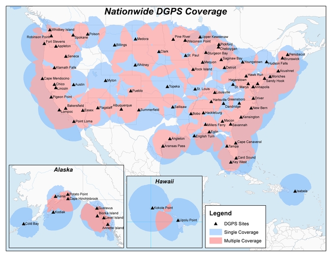
    A lot of whether GPS will retain its standard position has to do with worldwide confidence in the system. We’ve done a pretty good job of maintaining a level playing field for everyone in the world with regard to GPS. There haven’t been the problems that were experienced with Loran systems which were occasionally turned off, creating consternation in Europe. But the possibility, currently under consideration, of actually dropping an important accuracy augmentation element of GPS — the Nationwide Differential GPS (NDGPS) — before alternatives are available would certainly undermine worldwide confidence in the U.S. commitment to continuing to provide service equal to or better than what is already there.

    The key issue here: You can have all the paper designs in the world you want, but fundamentally the question is once you have a given level of capability, how well is that maintained — and is it improved over time?

    With all the machinations that have gone on, the United States has done a pretty good job. It basically delivers a set of signals that are better than promised. The system, especially with its augmentations, is clearly better today than it was 10 years ago.

    Now, the U.S. from a policy standpoint does need to transition from where we are to GPS III. We simply need to do it in a wise manner. The problem that I see with zeroing out the budget for NDGPS is that we save very little money — about $10 million a year to maintain the system. For any accountancy firm, this would fall below the line of relevance in the budget. And the effect, in undermining international confidence in GPS and in direct costs to state and local governments, would far outweigh any such savings.

    Until we have something in GPS III that provides accuracies in the half-meter range, which is what’s required for civil Geographic Information Systems (GIS) work, it would be foolish to turn NDGPS off. We would be degrading a system without any real alternative.

    Furthermore, you’re probably going to cost state and local and federal governments, who use NDGPS extensively for local mapping, far more than $10 million by turning the system off.

    I believe the main commercial use of NDGPS, outside of the GIS realm, is precision agriculture. The arguments to put it in originally were to provide the people on the interior of our continent the same sort of services that the coastal regions are provided. The issue we have is we don’t have a strong vocal constituency, and frankly state and local governments can’t provide much of a hue and cry for degradation of service.

    And losing confidence, undermining international confidence in the U.S. to maintain a stable system, is not a party to the table, either.

    Granted, international users do not actually use NDGPS itself. But they have invested the money to put in comparable base stations in their countries. For the U.S. to discontinue NDGPS undermines and brings into question whether their investment was a good investment — and whether, as an international user, you can comfortable continue to rely on GPS.

    It’s a confidence issue. There is no economic damage to foreign users. But it’s a perception of undermining GPS credibility across the globe if we pull back support from a system that just a few years ago we deemed to be important and almost essential.

    Some precision ag and other potential NDGPS users have switched over to WAAS, the Wide Area Augmentation System. There’s no question that WAAS is a good system, but you’re not going to get below a couple of meters, and you’re certainly not going to be able to farm above buried water tape. There’s clearly a market and I believe it’s part of the mix. It turns out it’s really tough to get at the 20-centimeter accuracy level over large distances, and WAAS will not give you that.

    At some point in our transition — I don’t know whether it’s five years from now or 10 years from now — the world is going to be a different place in terms of satellite services and the level of satellite services. It may very well be at some point in the future, this space of 20–50 centimeter accuracy can be very well delivered by a private service (without interference in the RF spectrum), or let’s just say, can be delivered by satellite.

    At that time, when there are truly other alternatives, I’m not going to be beating my shoe on the desk to maintain a legacy system. The issue in this whole positioning and navigation field is that as people are starting to get economic value out of information, introducing hiccoughs into the user stream of productivity enhancement is not a good thing.

    We say that until there is a viable alternative for the 20–50 centimeter space, we ought to continue sending out the signals. Once there is a viable alternative, then you can certainly transition; look at the cost of transition, and you will probably transition.

    But it turns out this is a relatively cheap way of providing information in this space and, frankly, we’re a long ways away from using GPS in automated systems that are directly related to safety of life. To get that, you have to play the game that the FAA plays, and worry about seven nines of reliability [99.9999999 percent]. GPS in its augmentation is probably at the one to two nine level. But as the usage increases, by having multiple augmentation systems and using them, there is no reason that reliability can’t be increased.

    Fundamentally, the word to government is it’s premature to shut off the lights. It may be the right decision at some point in the future, but I think it would cause a lot more problems than the $10 million it would save if it’s done now.


    CHARLES R. TRIMBLE is chairman of the U.S. GPS Industry Council.

  • NDGPS Gasping

    RITA and the Coast Guard have a tough job ahead. Between them, the Department of Transportation’s (DOT’s) Research and Innovative Technology Administration and the multi-mission maritime service are trying to save a national differential GPS (NDGPS) program that faces termination next year.

    History. The U.S. Coast Guard (USCG) implemented the concept in the mid-1990s. Their requirement was for marine navigation, and the system now provides service for coastal coverage of the continental United States, the Great Lakes, Puerto Rico, portions of Alaska, Hawaii, and a greater part of the Mississippi River Basin. In a testament to NDGPS’s success, many countries around the world have duplicated the concept.

    Since the DGPS signal is broadcast in a 360-degree radius, inland users close enough to the USCG broadcasting station can receive and use the corrections. All of this happened before SA (Selective Availability) was turned off, so the accuracy improvement was staggering; from 100 meters down to 1-3 meters. Once inland users tasted the sweetness of the USCG DGPS system, a groundswell of support arose for expanding the system inland. The NDGPS system was born.

    Manufacturers began to integrate “Coast Guard” DGPS receivers into their products. Companies like CSI and Starlink offered after-market DGPS receivers to enable virtually any GPS user to receive the free DGPS signal, whether it was a $200 consumer GPS unit or a $10,000 submeter mapping receiver. Since then, tens of thousands of “Coast Guard” DGPS receivers have been sold around the world.

    Between the USCG, the Army Corp. of Engineers (USACE), and the DOT, 86 stations now blast out DGPS corrections free of charge that cover more than 90 percent of the U.S. landbase.

    Trouble. The program ran smoothly through the first half of this decade. Each year, a few new stations were added to expand coverage. The HA (High Accuracy)-NDGPS concept to provide decimeter-level positioning was proven to work. However, the rug flew out from under NDGPS last year when DOT’s Federal Railroad Administration (FRA) announced it would no longer sponsor NDGPS. NDGPS supporters had long hung their hats on Positive Train Control (PTC) as the killer application for NDGPS, as it would save the railroad industry billions per year and justify the cost of installing and maintaining the NDGPS. The DOT says the PTC doesn’t need NDGPS any longer.

    Two significant developments have reduced the need for NDGPS since the program began. The first is that autonomous (standalone) GPS accuracy is very good these days, on the order of a few meters. The second is the maturation of the Federal Aviation Administration’s Wide Area Augmentation System (WAAS).

    RITA to the Rescue. Last summer, with no FY07 budget for NDGPS, the scrambling began. The FRA washed its hands of NDGPS so the DOT transferred the program to a little-known agency called Research and Innovative Technology Administration (RITA). At the eleventh hour, RITA scraped up $5 million for NDGPS for FY07 — enough to operate and maintain the system until October 2008. $400,000 of that is allocated for “needs assessment.” In other words, they need to understand who is still using NDGPS and determine if the usage justifies future funding.

    The USCG (39 sites), USACE (9 sites), and DOT (38 sites) fund the 86 stations. USCG has said it would take over 12 of the DOT-funded sites if DOT decides not to fund the program. So the debate only involves about a third of the U.S. land mass. The USCG and USACE sites are not in jeopardy, as their requirements are considered safety-of-life for maritime navigation.

    Is there is a significant enough user base in the areas above to justify the roughly $7 million a year it takes to operate and maintain them? If there are only 1,000 users in those regions who use it regularly, that’s $7,000 per year, per user. That scenario doesn’t make sense. And it doesn’t even consider the cost of complete system build-out. Even at 10,000 users (a very unrealistic number), that’s still a cost of $700 per year, per user to the taxpayer.

    Who still uses NDGPS, anyway? That’s the magic question, and the DOT doesn’t know the answer. Presumably, determining that is part of the needs assessment, to be

    finalized in September 2007. I’ve heard speculators talk about agriculture being a big NDGPS user. While this might have been true five years ago, WAAS now dominates the ag market. Even CSI (now Hemisphere GPS), the largest producer of after-market “Coast Guard” beacon receivers and the leading GPS supplier to the ag market, has shifted its focus from NDGPS receivers to high-performance WAAS receivers.

    The forest products industry comprises some big users of GPS, but they’ve been post-processing for years, and some have even stopped doing that because autonomous GPS is sometimes good enough.

    What’s left is a fragmented group of utilities, federal/state/local government, engineering, surveyors, universities. and various -ologists. Honestly, as much traveling, conference attending, speaking engagements, and training as I do, I can’t recall the last person who told me they use NDGPS. That’s the fundamental problem.

  • NDGPS Abandoned?

    The Federal Railroad Administration has relinquished responsibility for national differential GPS (NDGPS), saying that it no longer supports NDGPS for positive train control. DOT’s Research and Innovative Technology Administration (RITA) now has sponsorship of NDGPS, and will hold a meeting on October 4 to assess.

    The outlook for NDGPS appears bleak. “Without funding, the system faces tough choices.” Options reportedly under consideration include moth-balling the system for $2 million or shutting it down for $10 million. NDGPS supporters claim that a large mass of users of NDGPS have not yet been heard.