On Sept. 25, the GPS Directorate will host the 2019 Public Interface Control Working Group and Open Forum to update the public on GPS public document revisions.
The meeting will collect issues and comments for analysis and possible integration into future GPS public document revisions.
The 2019 Public Interface Control Working Group and Open Forum are open to the general public. It can be attended in person or by dial-in connection.
Documents Affected
IS-GPS-200: Navigation User Interfaces
IS-GPS-705: User Segment L5 Interfaces
IS-GPS-800: User Segment L1C Interface
ICD-GPS-870: NAVSTAR GPS Control Segment to User Support Community Interface
Meeting Address: SAIC, 100 N Sepulveda Blvd., El Segundo, CA 90245, The Great Room
The GPS Directorate has released updates to the below Interface Control Documents (ICD). ICDs are the formal means of establishing, defining, and controlling interfaces and for documenting detailed interface design definitions for the GPS program.
Updated Documents
IS-GPS-200: Navstar GPS Space Segment/Navigation User Interfaces
IS-GPS-705: Navstar GPS Space Segment/User Segment L5 Interface
IS-GPS-800: Navstar GPS Space Segment/User Segment L1C Interface
ICD-GPS-240: Navstar GPS Control Segment to User Support Community Interface
ICD-GPS-870: Navstar Next Generation GPS Control Segment (OCX) to User Support Community Interface
Download or view the updated ICDs at GPS.gov or NAVCEN.
59th CGSIC Meeting Set for September
The U.S. Department of Transportation (DOT) and the Coast Guard Navigation Center (NAVCEN) have announced plans for the 59th meeting of the Civil GPS Service Interface Committee (CGSIC).
The meeting will take place Sept. 16-17 at the Hyatt Regency Miami in Miami, Florida, in conjunction with the Institute of Navigation’s ION GNSS+ 2019 conference.
CGSIC meetings are free and open to the public. Subcommittees of the CGSIC for Timing, International Information, and Survey, Mapping, and Geosciences will hold meetings Sept. 16, and a summary of these meetings will be presented to the CGSIC plenary session Sept. 17.
The meeting will include important briefings on the status of ongoing GPS programs and a keynote address by Diana Furchtgott-Roth, deputy assistant secretary, Office of the Assistant Secretary for Research and Technology, U.S. Department of Transportation.
The Coast Guard Navigation Center has published a special notice to mariners that use GPS equipment. The special notice outlines the details of the GPS Week Number Rollover that will occur April 6-7.
To best prepare for the rollover event, users of GPS equipment who are concerned should update their firmware, or contact their equipment manufacturer to ensure their equipment is ready for this event.
When the week number reaches 1024 at 18 seconds before midnight (UTC) on April 6, it will reset to zero as it keeps counting. This has happened once before, in August 1999.
Recent devices have likely been designed to handle the rollover event.
Older GPS receivers, however, or receivers that have not been provided manufacturer updates, may be affected by the rollover. The impact might occur in April, or could affect such equipment at a later date. The date might revert back to August 1999, or may revert to another date. Since this issue does not affect the other parts of the GPS navigation message (it only affects the date), the receiver’s ability to calculate the position and to display the exact time of day should not be impacted.
Additional information about GPS and the GPS Week Number Rollover is available here:
Civil GPS users are encouraged to report disruptions or anomalies to the U.S. Coast Guard Navigation Center or via phone at 703-313-5900, 24 hours a day.
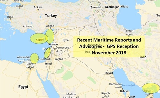
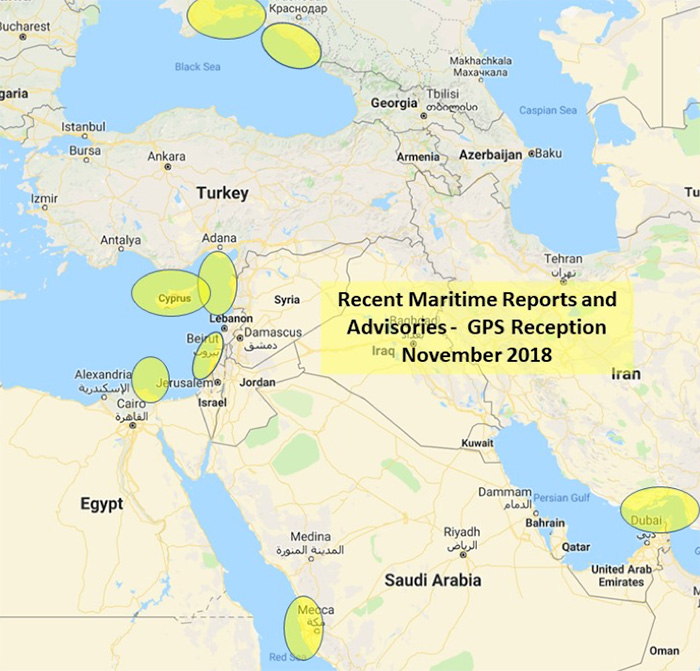
The U.S. Maritime Administration issued an expanded advisory for GPS disruptions in the Middle East. The new advisory renews and repeats warnings for the eastern Mediterranean and adds the Port of Jeddah in Saudi Arabia.
Reports have also been filed with the U..S Coast Guard Navigation Center about disruptions in Israel’s Port of Haifa and the Straits of Hormuz.
Analysis by the Resilient Navigation and Timing Foundation and the non-profit firm C4ADS has also shown on-going disruptions in Russian waters of the Black Sea. Also, GPS jamming by Russia is suspected during a recent NATO exercise.
The armed conflict in Syria has been blamed for much of the disruptions off of its shores.
GPS jamming in support of illegal fishing is suspected by some as the cause of problems off of Port Said, and disputes over mineral rights has been suggested for the disruptions seen near Cyprus.
Disruptions in the Black Sea are suspected to be security measures associated with the travel of Russian government officials.
Map: U.S. Maritime Administration Advisory 2018-014-GPS
Text of Maritime Administration Advisory
2018-014-GPS Interference-Eastern Mediterranean and Red Sea
This revised advisory cancels U.S. Maritime Advisory 2018-007.
Reference: U.S. Maritime Alerts 2018-004A, 2018-004B, 2018-008A.
Issue: Multiple instances of significant GPS interference continue to be reported by vessels and aircraft operating in the Eastern Mediterranean Sea. These reports have been concentrated near Port Said, Egypt, the Suez Canal, and in the vicinity of the Republic of Cyprus. Additional instances of similar interference were reported in October 2018 near Jeddah Port, Saudi Arabia. This interference is resulting in lost or otherwise altered GPS signals affecting bridge navigation, GPS-based timing and communications equipment.
Guidance: Exercise caution when transiting these areas. The U.S. Coast Guard Navigation Center (NAVCEN) and NATO Shipping Center websites contain information regarding effective navigation practices for vessels experiencing GPS interference. The information reaffirms safe navigation practices when experiencing possible GPS disruption, provides useful details on reporting possible GPS disruption, and is intended to generate further discussions within the maritime community about other disruption mitigation practices and procedures. This guidance also recommends taking note of critical information such as the location (latitude/longitude), date/time, and duration of the outage/disruption, and providing photographs or screen shots of equipment failures during a disruption to facilitate analysis. The NAVCEN information is available at https://go.usa.gov/xQBaU.
Contact Information: GPS disruptions or anomalies should be immediately reported to the NAVCEN at https://go.usa.gov/xQBaw or via phone at 703-313-5900, 24 hours a day. The NATO Shipping Center has requested that instances of GPS interference also be reported to them using the format on their Cyber Interference link.
Cancellation: This message will automatically expire on May 2, 2019.
The U.S. Coast Guard Navigation Center (NAVCEN) is now publishing reports of GPS problems on its website. Any notes about problem resolution, if available, will also be listed.
The website will be updated as new reports are received and processed. All reports made in 2018 are now available, and reports for prior years will be made available in the future.
The reports are being made “to provide better service and situational awareness to the public,” wrote Rick Hamilton, CGSIC executive secretariat, NAVCEN.
Reports will be anonymized to protect the submitter’s personal information and any equipment manufacturer data.
After user and interagency partner input has been collected, any findings will be added to the report along with the suspected cause and resolution, if available.
The webpage will include the following information for each report:
Date/Time of Disruption: Date and time of the report as provided by the reporting source.
Date Submitted: Date the report was submitted to NAVCEN.
Location: The general location of the reported problem based on input from the reporting source. Latitude and longitude may be used for maritime reports.
Type: Installation type as provided by the reporting source. Choices include agriculture, automobile, aviation, communications, first responder, marine, law enforcement, research, surveying, timing, transportation and other (with a fillable field).
Description: Description of the problem. This information from the reporting source is edited for clarity and to remove personal and equipment manufacturer identifying details. The description also provides GPS satellite constellation analysis information as provided by the GPS Operations Center, a determination if authorized GPS testing might have been a factor, and information on correlating reports from other users and interagency partners.
Cause: The most likely cause of the report based on interagency input.
NAVCEN Closed Date: NAVCEN collects interagency input and provides a detailed response to the reporting source for each report submitted. If there are no further questions from the reporting source, and NAVCEN has no other correlating information, NAVCEN will close the case. The results of interagency input will be included in the description field when the case is closed. This date may not correspond to the event end date.
Civil GPS users are encouraged to submit reports of GPS problems to the Coast Guard Navigation Center.
Civil aviation users are encouraged to report GPS anomalies to the Federal Aviation Administration, and military users should contact the GPS Operations Center.
In a notice advisory to NAVSTAR Users (NANU), the U.S. Coast Guard Navigation Center announced that starting March 7, after 22:00 Zulu hours, GPS will transition satellite SVN34 (PRN18) into the broadcast almanac for all satellites.
The almanac transition, one satellite at a time, will require approximately 24 hours to complete.
Also, on approximately March 8, SVN34 will resume transmitting L-band utilizing PRN18. SVN34/PRN18 will be unusable until further notice.
Future NANUs will notify users of any changes to the above stated status.
Contact the navigation center for more information:
DOT serves as the civil lead for the GPS and chairs the CGSIC in this capacity. NAVCEN is assigned duties as deputy chair and executive secretariat for the CGSIC.
Subcommittees of the CGSIC for Timing, State and Local Government, International Information, and Survey, Mapping and Geosciences will hold meetings Sept. 25, and a summary of these meetings will be presented to the CGSIC plenary session Sept. 26.
The keynote speaker for this year’s plenary session will be Keith Conner, Ph.D., Senior Engineer, Science and Technology First Responders Group, U.S. Department of Homeland Security.
Presentations include:
Operational status and modernization of the GPS constellation of satellites
U.S. Space-Based Position, Navigation and Timing policy
GPS augmentation systems
Briefings from the National Aeronautics and Space Administration (NASA) and the National Parks Service
Information related to U.S. engagement with other international Global Navigation Satellite Systems as well as a variety of applications of the use of GPS
The full agenda is available. CGSIC presentations will be posted online shortly after the meeting ends.