Tag: NAVISP

  • Real-time interference detection by GIDAS makes satnav safer

    Real-time interference detection by GIDAS makes satnav safer

    It is estimated that there are currently the same number of satnav receivers on Earth as there are people. (Image: ESA)
    It is estimated that there are currently the same number of satnav receivers on Earth as there are people. (Image: ESA)

    News from the European Space Agency (ESA)

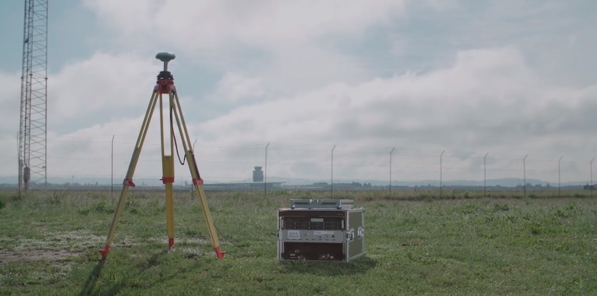
    A new monitoring system developed through an ESA-backed project works like a bodyguard for satellite navigation in use at strategic or safety-critical sites. Known as GIDAS, the scalable system immediately detects, identifies and pinpoints satnav interference sources in its vicinity.

    It is estimated that there are currently the same number of satnav receivers on Earth as there are people. Positioning, navigation and timing signals from space-based constellations such as Galileo and GPS form an invisible, essential infrastructure, underpinning numerous modern aspects of modern life: communications, power and transportation.

    Satellite navigation helps guide a growing number of aircraft, boats, trains and autonomous vehicles. Meanwhile satnav-based time stamps authentic multi-billion euro financial transactions, and coordinate the synchronised running of power grids. Satellite navigation is always on, available everywhere on Earth, so it is easy to take its availability for granted. But as crucial as these signals from space are, they are also vulnerable to ground-based interference.

    “It’s simply a matter of output power,” said Andreas Lesch of Austria-based OHB Digital Solutions. “A navigation signal on the ground is equivalent to the light from a 60-watt lamp aboard a satellite, some 23,222 km away in space in the case of Galileo. So these faint signals can be jammed by more powerful local radio signals, either accidentally or deliberately, or even misleading fake navigation signals, known as spoofing.”

    “Our new GNSS Interference Detection and Analysis System, GIDAS, is designed to safeguard critical infrastructure against jamming or spoofing, by performing continuous monitoring of key signal bands. By doing so, GIDAS can raise the alarm in real time, identify the type of interference then pinpoint the location of these dangerous portable devices causing the interference so the authorities can take immediate remedial action.”

    GIDAS can provide interference detection and directionality with a single reporting station, although a minimum of three stations are required for pinpointing interference sources, linked to an overall monitoring center. Monitoring centers can also be connected together, making the GIDAS system easily scalable, from safeguarding an individual harbour, airport or system critical site up to an entire city or region.

    GIDAS can provide interference detection and directionality with a single reporting station, although a minimum of three stations are required for pinpointing interference sources, linked to an overall monitoring center. (Photo: ESA)
    GIDAS can provide interference detection and directionality with a single reporting station, although a minimum of three stations are required for pinpointing interference sources, linked to an overall monitoring center. (Photo: ESA)

    “People are only now catching up to the seriousness of this problem,” adds Andreas. “Surveys of the highest-density parts of Europe surveys report around three to four jammers hourly.

    “These small devices are technically illegal but are easily available online for a few hundred euros or less, often marketed as personal privacy devices. Jammers are sold as having a range of only a few metres, but can turn out to have a practical range of dozens of metres or more — leading to unintentionally widespread interference, like the famous jammer-equipped U.S. truck driver who shut down Newark Airport navigation systems whenever he drove past.

    “Spoofing is more serious still, with a strong criminal element, where false satellite navigation signals replace real ones, to mislead receivers about their position, employed in the past to down put drones or divert boats.

    “Working in this field for eight to nine years, we have seen a strong growth in interference, even as GNSS becomes ever more crucial. With our passion for GNSS and signal processing, we decided to something practical to combat this development, delivering rapid detection, classification and localisation of interference to our customers.”

    GIDAS was developed by OHB Digital Solutions and Joanneum University through ESA’s Navigation Innovation and Support Programme (NAVISP), working with European industry and academia to develop innovative navigation technology.

    “The company initiated the project through NAVISP’s second element, focused on strengthening European competitiveness in the navigation arena, proceeding on a co-funded basis,” said engineer Thomas Burger, overseeing GIDAS project for ESA. “The plan was to enable a commercially attractive business to get started, and I’m happy to say we made it.”

    “Considering the budget, the project had a wide scope, including the development of a multi-constellation GNSS receiver with all processing stages, an extended digital front end for jamming and spoofing detection, processing blocks transferred to a parallel processor based on a customised fully programmable gate array.

    “And that was only one ingredient of the overall GIDAS system, also including the actual interference detection machinery, the interference locating subsystem, and all the communication, database, and graphical user interface elements needed to create a distributed, human-usable system — which is able to go on working autonomously, only asking for human involvement when events are detected.”

    Now that its two-year NAVISP project has concluded, GIDAS is now being rolled out to several Europe-based governmental and private sector customers.

  • Testing suspended on Galileo Batch 3 satellites

    Testing suspended on Galileo Batch 3 satellites

    In response to the ongoing coronavirus pandemic, the test campaign for the first two satellites of Galileo’s Batch 3 has been suspended.

    The suspension is based on the medical advice for social distancing — too high a concentration of people is needed on site if testing were to continue, according to the European Space Agency (ESA).

    An aerial view of ESTEC. The Erasmus building is at front right. The T building (home to ESA's Galileo team) is in the foreground. (Photo: ESTEC)
    An aerial view of ESTEC. The Erasmus building is at front right. The T building (home to ESA’s Galileo team) is in the foreground. (Photo: ESTEC)

    The satellites are based at the ESTEC Test Centre in the Netherlands for engineering tests ahead of launch. The stored satellites are being monitored by staff visiting ESTEC every few days, to verify that all is in order.

    Other Galileo-related testing continues with the aim of supporting future launches. ESTEC-based lifetime testing of the next set of rubidium atomic clocks is set to continue, involving on-site monitoring every few days.

    Working from home

    ESA’s Directorate of Navigation has shifted to teleworking while also ensuring the continuity of essential tasks, in particular the continued delivery of positioning, navigation and timing services of both Galileo and EGNOS.

    The ESA team is using video and audio conferences to continue meetings with the industries involved and minimize the impact on the deliveries of EGNOS upgrades, Galileo Batch 3 satellites, and preparatory work for Galileo Second Generation.

    The national, local and industrial decisions on travel, meetings and quarantine are impacting the ability to deliver all ongoing commitments, so measures are being taken to minimize their impact, ESA said in a press release.

    Priority has been given to ensure continued operations of both EGNOS and Galileo, so the ESA Navigation Directorate has been supporting the European GNSS Agency (GSA), the operator of Galileo and EGNOS, on behalf of the European Commission.

    The team also is maintaining constant contact with various stakeholders.

    NAVISP and Horizon 2020

    Research and development projects under the Directorate’s Navigation Innovation and Support Programme (NAVISP) are continuing at a somewhat slower pace, given the crisis. So are satellite navigation projects financed by the EU’s Horizon 2020 programme, which develop future technology for the EU satellite navigation projects.

    “Confronted with this unprecedented situation, our efforts are focussing on business continuity and supporting the GSA with services provision of Galileo and EGNOS, while taking all necessary measures to protect our personnel,” said Paul Verhoef, ESA Director of Navigation. “An impact assessment will only be possible when we see the end of the restrictions in the various European countries. For the time being, stay home, stay healthy, is the priority, whereas however we are in close contact with industry to try and keep momentum on the projects that are underway.”

  • ESA to use CORS networks for global error mapping

    ESA to use CORS networks for global error mapping

    News from the European Space Agency

    There are more than five billion satnav devices on Earth. Along with smartphones and mobile receivers, this figure includes networks of fixed receiver stations, used to improve accuracy. An ESA-led project will harness these networks to provide an ongoing overview of satnav performance from the global to national and regional scale.

    <b>CORS station:</b> The CORS network is a multi-purpose cooperative endeavor involving government, academic and private organizations. The sites are independently owned and operated. Each agency shares its data with NGS, and NGS in turn analyzes and distributes the data free of charge. (Photo: NOAA)
    CORS station: The CORS network is a multi-purpose cooperative endeavor involving government, academic and private organizations. The sites are independently owned and operated. Each agency shares its data with NGS, and NGS in turn analyzes and distributes the data free of charge. (Photo: NOAA)

    “The general assumption is that Global Navigation Satellite System (GNSS) services can always be relied on, which is true 99% of the time,” commented Michael Pattinson of Nottingham Scientific Ltd. in the United Kingdom, which is developing this new project for ESA.

    “That’s fine for the ordinary smartphone user, but for safety-critical applications, in particular, we need to know exactly when systems are not performing optimally, and why.

    “Current performance monitoring is often partial, based around individual signal frequencies or constellations, carried out by the service operators themselves. With our new COLOSSUS — Crowd-Sourced Platform for GNSS Anomaly Identification, Isolation and Attribution Analysis — data platform, we’ll be creating the most detailed possible picture of overall performance from the user side, covering all satellite constellations, signal frequencies and receiver types.

    OS Net Station: A CORS station in Tiree, the Hebrides, part of the Ordnance Survey's 110-strong OS Net network. (Photo: ESA)
    OS Net Station: A CORS station in Tiree, the Hebrides, part of the Ordnance Survey’s 110-strong OS Net network. (Photo: Ordnance Survey)

    “The aim is to immediately identify system failures, faults and other errors on an immediate, autonomous basis. And we’ll do this by harnessing a resource that is already out there: gathering and analysing positioning data from networks of ‘continuously operating receiver stations’, known as CORS for short.”

    There are many hundreds of these CORS stations across the globe. By performing positioning continuously at a fixed site in the landscape, they can be used as a standard, serving to identify and subtract measurement errors to boost positioning accuracy on a localised basis.

    Many CORS networks have been established for scientific uses, such as the worldwide International GNSS Station (IGS) network, used as a standard geographical reference and to measure shifts in the solid Earth, oceans and ice.

    Others have been set up by national mapping agencies, such as the Ordnance Survey in the UK. There are also private-sector networks, employed for improving the accuracy of services such as land surveying, air service providers, road charging or driverless cars.

    IGS Global Network: the worldwide International GNSS Station (IGS) network of CORS stations is used as a standard geographical reference and to measure shifts in the solid Earth, oceans and ice.(Image: ESA)
    IGS Global Network: the worldwide International GNSS Station (IGS) network of CORS stations is used as a standard geographical reference and to measure shifts in the solid Earth, oceans and ice.(Image: ESA)

    “Each network is different,” added Pattinson. “Some make their data freely available, others involve registering or payment. We’re talking to operators to allow us to access their data in exchange for sharing our results, and they’re very interested in accessing such performance metrics.

    “With measurements from so many sites, when a failure does occur we’ll be able to pin down its likely source almost immediately. Is it localised interference, or does it have a wider impact? Is it atmospheric disturbance? Is only a single model of GNSS receiver affected, or multiple types? Is it a problem with a single satellite, multiple satellites or even multiple constellations?”

    The company is also deploying its own CORS receivers as an additional data source, at the same time as it develops and tests its processing algorithms. The aim is to begin testing the cloud-based COLOSSUS towards the end of 2019 and bring the service online in the first few months of 2020.

    “Once the service starts, it will run continuously, just like the CORS stations themselves,” Pattinson said. “Our goal is for COLOSSUS to become a key player in GNSS performance monitoring, building up a database of all anomalies that occur and their consequences in terms of constellations, geographical regions and receiver types, to give users, service providers, and regulators an informed sense of how much ‘trust’ to place in these systems.”

    This project is supported through ESA’s Navigation Innovation and Support Programme, NAVISP, applying ESA’s hard-won expertise from Galileo and Europe’s EGNOS satellite augmentation system to new satellite navigation and — more widely — positioning, navigation and timing challenges.

  • Anti-jam, anti-spoof readied for European market

    New initiatives from the Navigation Innovation and Support Programme (NAVISP), a program of the European Space Agency (ESA), have targeted counter-jamming and counter-spoofing efforts, as Europe’s Galileo program gains progressive foothold in the marketplace, particularly in safety-critical systems such as driverless cars.

    “We are looking for new and disruptive ideas in navigation and that is why we created NAVISP,” said ESA Director General Jan Wörner.

    TeleConsult Austria is working with JH Joanneum University of Applied Sciences on the GNSS Interference Detection and Analysis System (GIDAS), to automatically detect, classify and pinpoint all intentional interference sources within a given area by monitoring all civil GNSS signals in real time.The aim is to build a multi-frequency scalable system. GIDAS plans to begin commercialization at the end of 2019.

    France Developpement Conseil has developed a hardened satnav module called DRACONAV, combining hardware and software to combat jamming and spoofing. Targeting intelligent transport applications, it seeks to identify cyber attacks and continue to provide authenticated positioning information as they occur.

    DRACONAV would deliver a level of confidence to let users know if they can continue relying on the data the module delivers, and yield an estimate of the receiver’s true position as the attack continues. A prototype design has undergone more than 3,000 kilometers of field tests and is moving to industrialization.

    Intecs Solutions of Italy has created G-Passion, using a software-defined radi

    o to analyze a few tens or hundreds of milliseconds of Galileo signals at a time, to tell the user whether or not the signal is authentic or spoofed.
    In Romania, InSpace Engineering’ MARGOT assesses the multipath and interference impact on PNT information in maritime environments.

    The Norwegian company SINTEF is developing its Advanced Radio Frequency Interference Detection, Alerting and Analysis System (ARFIDAAS) project, offering as wide a spectral coverage as possible — including all current GPS, Galileo and GLONASS signals — to identify disruptions due to intentional or unintentional interference.

    UK company Helix Technologies has developed compact helical antennas, built around a dielectric ceramic core, primarily for driverless cars. The multi-frequency design aims to reduce susceptibility to interference as well as multipath. Testing will soon get underway in several European cities.

  • Directions 2019: Galileo moves toward FOC

    Directions 2019: Galileo moves toward FOC

    Countdown team at Kourou, Guiana control center for July’s four-satellite launch. (Photo: ESA/CNES/Arianespace, P. Baudon)
    Countdown team at Kourou, Guiana control center for July’s four-satellite launch. (Photo: ESA/CNES/Arianespace, P. Baudon)

    By Javier Benedicto
    Head, Galileo Programme department, European Space Agency

    Since the declaration of initial services in December 2016, the European Space Agency (ESA) and the European GNSS Agency (GSA) have expanded Galileo’s system capabilities and service robustness with significant improvements of the ground segment and the last batch of four satellites launched by Ariane 5 in July. Once these satellites reach their final position and complete their in-orbit commissioning before the end of 2018, all 24 nominal slots of the Galileo constellation will be occupied.

    Up to 22 satellites are planned to be commissioned in early 2019 and, eventually, the two FOC satellites injected in elliptical orbit should join the operational constellation after on-board software upgrade to provide for automatic health status flagging to users. This should lead to a total of 24 operational Galileo satellites supporting global PNT for users worldwide.

    New Infrastructure Contracts

    To further expand the system capabilities by 2020 and beyond, and reach Full Operational Capability (FOC), ESA has awarded new large industrial contracts in the context of the Exploitation Phase.

    A contract to build and test another twelve Galileo satellites (so-called Batch-3) was awarded in 2017 to a consortium led by prime contractor OHB GmbH in Germany, with Surrey Satellite Technology Ltd in the UK as payload prime. These new satellites are based on the already qualified design of the previous Galileo FOC satellites. Production is advancing well, with first launch planned by late 2020.

    With the Galileo constellation now expanded to 26 navigation satellites and plans to deploy additional Batch 3 satellites, the ground control infrastructure is undergoing a corresponding upgrades. In July, ESA awarded a new contract for the Galileo Ground Control Segment to GMV Aerospace and Defence, Spain. This contract includes upgrading the system architecture to manage a constellation of up to 41 Galileo satellites, updating obsolescent elements in the current system, improving operability linked to the provision of services and additional telemetry, tracking, and command capabilities to improve system robustness.

    In October, Thales Alenia Space in France received a contract to upgrade the Galileo Ground Mission Segment and the Galileo Security Monitoring Centres (GSMC). This work includes upgrading Galileo’s system architecture to provide more accurate navigation products for broadcast by Galileo satellites, updating obsolescent elements in the current system and improving operability linked to the provision of services and enhanced robustness.

    It will also include the construction of additional navigation message uplink and sensor stations. This contract will also augment the capabilities for implementation of the Public Regulated Service (PRS), the single most accurate and secure class of Galileo signals. Encrypted PRS signals will be made available only to authorized governmental users through approved national authorities. GSMCs in France and Spain will ensure the security monitoring functions for Galileo operational assets and manage PRS access and operations.

    Growing Service Portfolio

    The European Commission, GSA and ESA have jointly defined a broad range of service improvements and system capability enhancements to be deployed in 2019–2020, leading to FOC.

    The newly qualified system infrastructure will support the broadcast of authentication information as part of the Open Service Navigation Message in E1; experimentation will start by end of 2019, leading to the possibility to offer trusted PNT to Galileo users.

    Galileo will also be the first GNSS constellation to provide a Search and Rescue return link capability: as of 2019 the system will allow broadcast of acknowledgement of receipt message to users in distress with a very low latency, contributing to saving lives.

    ESA has also started preparing the necessary modifications to the Navigation Signal Generation on-board the satellites to offer further capabilities to users after 2020. The signal-in-space will be enhanced with additional data transmitted in the I/NAV message, offering faster acquisition and more robust Galileo positioning on E1 and an encrypted navigation signal on E6 supporting authentication at signal level.

    The new Galileo High Accuracy Service, soon entering the experimental phase, will consist in the delivery of un-encrypted high accuracy correction data in E6, enabling users to achieve sub-meter level positioning.

    The usage of Galileo Open Service for aviation applications using horizontal advanced receiver-autonomous integrity monitoring techniques is being carefully assessed through measurements and review of the system design, including feared-events characterisation.

    Longer Term Evolution

    Galileo Second Generation has been the subject of technology pre-developments in the areas of platform and payload critical equipment, system techniques and processing algorithms, as well as system and segment Phase B studies over the past few years. We are now approaching the start of the implementation phase.

    The European Commission, in close consultation with EU member states, has defined a decision roadmap aiming at very important future budget and programme implementation decisions in the course of 2019. In this context, ESA has launched a competitive procurement procedure for the first batch of so-called “Transition Satellites” with a broad range of enhanced and some new capabilities being considered. This includes improvements in the signal domain for faster acquisition and lower receiver power consumption, on-board clock technology, inter-satellite links, electrical propulsion, flexible payloads and power allocation by means of on-board digital technology and in-orbit re-configurability.

    Transition satellites and related ground segment development contracts will begin by the end of 2019, aiming at in-orbit validation of second-generation capabilities from 2025 onwards.

    EGNOS Evolution for Aviation

    The adoption of Europe’s SBAS EGNOS by aviation is growing faster and faster. EGNOS will continue to evolve in the coming years. In particular, for 2019 and 2020, the evolutions under implementation focus on the obsolescence management of the hardware of some critical components, improvement of the system performances thanks to addition of new stations and system algorithms.

    All these evolutions are planned to be qualified in 2021-2022, to continue to offer an excellent level of performance to Aviation Users until the operational take-over by the second generation of EGNOS V3,planned in 2025.

    The European Performance-Based Navigation Implementing Regulation plans a growth from the current 35% to 66% in 2020 and 100% in 2024 of all European airports instrumental runways end-equipped with SBAS localizer performance with vertical guidance procedure.

    On the aircraft manufacturer side, Airbus confirmed that it will continue equipping its aircraft; following the A350 family already equipped, both A320 and A330 families will be equipped for entry into service in summer 2020.

    NAVISP

    ESA’s Navigation Innovation and Support Programme (NAVISP), launched in 2017, will continue to boost member states’ industrial competitiveness and innovation in the upstream and downstream navigation sector, investigate the integration of satellite navigation with non-space technologies and complementary positioning and communication techniques, and study novel receiver-based techniques to counteract vulnerabilities and improve the robustness and reliability of GNSS.

    Conclusion

    The EU-built GNSS infrastructure systems EGNOS and Galileo are operational and serving users in Europe and worldwide. EC, GSA, ESA and European industries are committed to improvement plans over the next 2–3 years, with emphasis on endurance, resilience and robustness of the systems’ infrastructure, and delivering enhanced services.

    For the longer term, the real challenge is to modernize the systems with new spaceborne and ground technologies, increase operational robustness and automation, and provide for additional system capabilities, while retaining a large degree of flexibility and in-orbit re-configurability to meet the long-term challenges and evolution of satellite-based navigation and timing.

  • Helix Technologies wins ESA contract to develop Galileo antenna

    Helix Technologies Ltd. has been awarded a significant contract by the European Space Agency (ESA) to develop its next-generation GNSS antenna — a multi-frequency antenna optimized for the advanced Galileo E1 Alt-BOC and wide-band E5 Alt-BOC waveforms for use in driverless cars.

    The antenna, to be developed under the ESA’s Navigation Innovation and Support Programme (NAVISP), will provide enhanced performance due to its dielectric, multi-filar construction. It will also be optimized to take maximum advantage of the Galileo E5 Alt-BOC waveform, which enables significantly improved measurement accuracy, precision and multipath suppression over conventional GNSS signals.


    Learn more about the Helix Technologies antenna in our February issue article here.


    “In order to achieve the 10-centimeter accuracy that is required for autonomous vehicle lane-level positioning within challenging urban multi-path propagation conditions, there is a need both for a significant improvement in current GNSS antenna performance and to fully exploit the advanced Alt-BOC waveforms transmitted by Galileo,” said John Yates, managing director of Helix Technologies.

    The GNSS antenna, which will also be capable of optimized operation with the GPS L1 and L5 M BOC signals, is aimed at the automotive and consumer markets, and the company is targeting the third quarter of this year for the manufacture of prototypes.

    Independent testing and evaluation of the vehicle-mounted antenna performance will be conducted in the challenging multipath environments of the high-rise financial districts of the cities of London and Shanghai.

  • Rolls-Royce, ESA collaborate on autonomous shipping

    Rolls-Royce and the European Space Agency (ESA) have signed a cooperation agreement aimed at pursuing space activities in support of autonomous, remote-controlled shipping and promoting innovation in European digital logistics.

    The collaboration with Rolls-Royce aims to study the applications of various space assets to autonomous shipping, such as satellite-based positioning, better situational awareness using Earth observation data, and satcom services for improved onboard connectivity. It aims to develop and validate new solutions for communication between vessel systems and shore-based systems in addition to ship-to-ship communication.

    This will pave the way for the operation of commercial remote and autonomous shipping, innovative cargo logistics, smart ports and future commercial marine vessels.

    The partnership will enable satellites to serve navigation, ship intelligence, marine operations, cargo logistics, maritime safety, healthcare, passenger and crew communications.

    The next generation of 5G communications will rely on seamless integration of telecom networks and services, and ESA’s Satellite for 5G Initiative supports the technical and supply chain progress required, and will support development of 5G commercial services.

    The Memorandum of Intent (MOI) forms part of ESA’s wider strategy. In its new navigation research and technology programme, called the Navigation Innovation and Support Programme (NAVISP), ESA is studying and testing technologies for smart ships.

    NAVISP is investigating the integration of satellite navigation with non-space technologies and complementary positioning and communication techniques. NAVISP will apply ESA’s expertise from Galileo and EGNOS to new satellite navigation and, more widely, positioning, navigation and timing (PNT) challenges.

    ESA already serves the maritime community with many satellite capabilities. SAT-AIS (Satellite Automatic Identification System) permits identification and global tracking of ships using cutting-edge space and ground technology, using low Earth orbiting satellites to act as information relays to serve the whole globe. This results in more efficient use of existing infrastructures, a tangible reduction in cost and a decrease in the environmental impact.

    The ESA developed Sentinel-1 satellite, part of the European Union’s Copernicus programme, is establishing a pivotal role in the sector. Last August, Sentinel-1 Earth observation data helped the U.S. Coast Guard vessel Maple navigate through the legendary Northwest Passage, showcasing the enormous potential that satellite earth observation can have across the industry, particularly in ship-to-ship data transmission.

    Rolls-Royce and ESA also plan to cooperate in harnessing the power of big data. Data analytics, Machine Learning and Artificial Intelligence (AI) can improve operational efficiency, reliability and safety.

    Sensor data will inform augmented and virtual realities, or “digital twins.” A digital twin is an AI copy of a ship, including its systems, that synthesises the information available about the ship in a hologram.

    “It allows any aspect of an asset to be explored through a digital interface, creating a virtual test bench to assess the safety and performance of a vessel and its systems, both before its construction and through its lifecycle,”  said Karno Tenovuo, SVP ship intelligence at Rolls-Royce. “By creating ships and ship technology in a virtual environment, new ideas and technology can be realized and tested in a shorter time frame.”