Tag: NAVWAR

  • Army approves requirement for Navigation Warfare

    Army approves requirement for Navigation Warfare

    The U.S. Army’s Assured Positioning, Navigation and Timing/Space Cross-Functional Team has approved the Navigation Warfare Situational Awareness Abbreviated Capability Development Document (A-CDD), signed March 25.

    The A-CDD validates the operational need and enables experimentation and rapid prototyping for NAVWAR-SA capabilities for the warfighter.

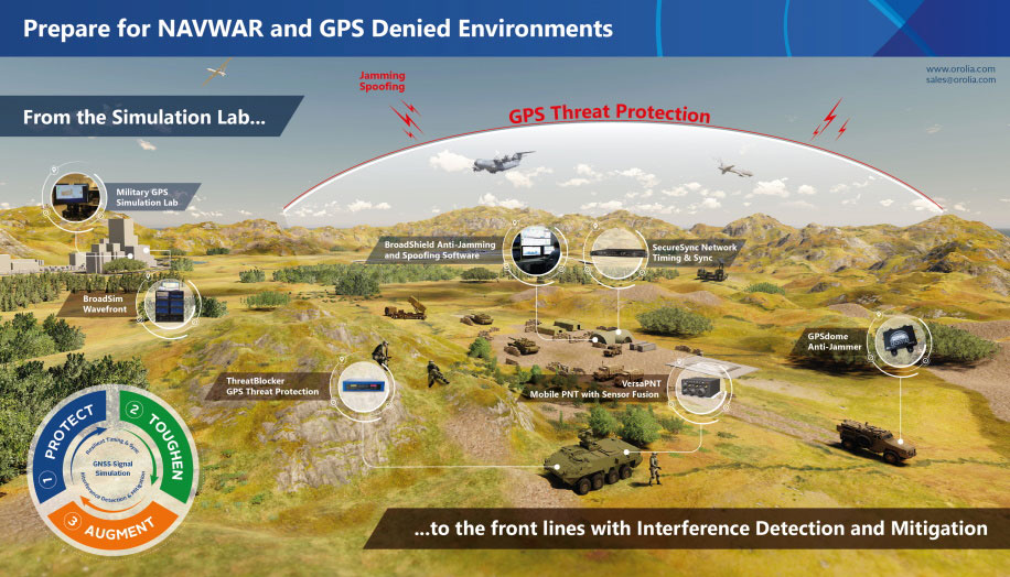
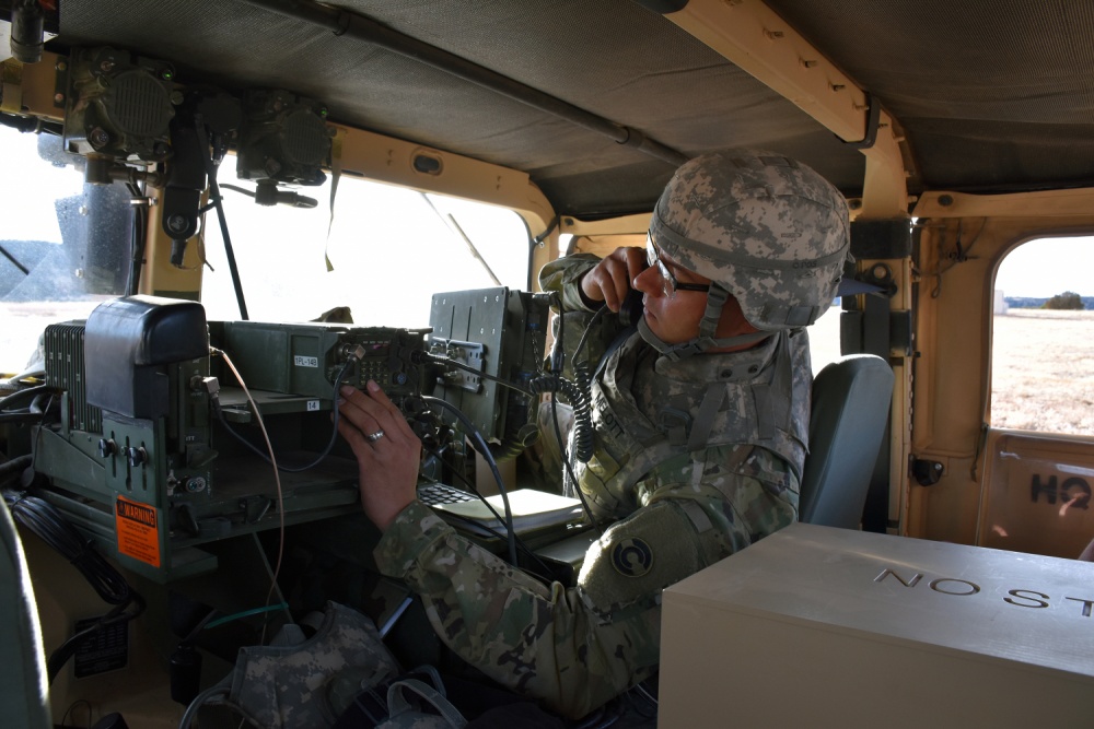
    NAVWAR is deliberate offensive and defensive actions to assure friendly use and prevent adversary use of positioning, navigation and timing information. NAVWAR supports Multi-Domain Operations as an enabler to precision fires, movement and maneuver, force tracking, and a host of data networks that tie personnel and weapon systems together into a joint or coalition force.

    NAVWAR-SA provides the capability to detect, identify and locate sources of interference that deny or degrade reception of PNT. It is intended to validate PNT signal integrity and provide users with indication and warnings of the presence and intensity of interference.

    NAVWAR-SA will also characterize the operating environment through the integration of multiple sensors that are able to detect, identify and geolocate sources of intentional and unintentional interference.

    William Nelson, Director, APNT CFT
    William Nelson, Director, APNT CFT

    “This A-CDD will enable us to accelerate critical NAVWAR technology development and streamline the process of expediting an operationally relevant system to our warfighters,” said Willie Nelson, director for the APNT/Space CFT. “This capability will enhance our ability to provide real-time situational awareness of PNT reliability to soldiers and commanders on the battlefield, which will enable Long-Range Precision Fires and support freedom of maneuver of large scale ground combat operations.”

    NAVWAR-SA will give the Army Forces the ability to “sense” the PNT environment in real-time, allowing commanders and units to maneuver with confidence and with precision when the global positioning system is degraded or denied. This is critical element of NAVWAR operations.

    The APNT CFT coordinated with organizations across the modernization enterprise to get the NAVWAR-SA A-CDD approved. The Army Capability managers for Space and High Altitude played a major role in developing the written requirement and getting it through the approval process.

    “The requirements provided in the NAVWAR-SA A-CDD are a first step in developing dedicated NAVWAR capabilities for our soldiers and are a key enabler in enhancing lethality in combat operations,” said Col. Tim Dalton, Army Capability manager for Space and High Altitude director.

    The A-CDD details methods to leverage new and existing solutions for rapid prototyping, testing and soldier assessment. The APNT/Space CFT will utilize the “buy, try and decide” process to accelerate the development of critical enabling technologies and streamline the process of transitioning a scalable, interoperable and agile capability to the field. This process will inform NAVWAR-SA requirements for current and future Army systems.

    “NAVWAR-SA will strengthen the Army’s ability to conduct military operations in PNT-challenged environments,” said David Pinckley, NAVWAR director for the APNT/Space CFT and chairman of the NATO NAVWAR Capabilities Team. “The unfortunate reality is that our systems will continue to be challenged by our adversaries so we are working with our joint and coalition partners to preserve military capabilities while mitigating impacts of interference.”

    NAVWAR is one of the three APNT/Space CFT Signature Efforts, which will deliver offensive and defensive NAVWAR capabilities in conjunction with existing Department of Defense NAVWAR policies.

    Joint and coalition forces conducting military operations will employ NAVWAR-SA to coordinate and implement mitigating actions to overcome PNT challenged environments.

    The APNT/Space CFT plans to assess and test NAVWAR-SA prototypes later this year, during Project Convergence 21 and the CFT’s annual PNT Assessment Exercise at the White Sands Missile Range, New Mexico.

  • US Air Force awards $20M to Alion for autonomous navigation

    US Air Force awards $20M to Alion for autonomous navigation

    The U.S. Air Force Institute of Technology (AFIT) has awarded Alion Science and Technology a $20 million task order for a 60-month period to provide Autonomy and Navigation Technology (ANT) development.

    The ANT Center is a forward-looking research center within the AFIT seeking to identify and solve tomorrow’s most challenging autonomy and navigation problems.

    The ANT Center’s goal is to develop navigation technology that ensures the Department of Defense (DOD) can navigate anywhere, anytime, using anything, and to improve the DOD’s ability to conduct autonomous operations.

    Alion will research, assess, analyze and develop the ANT Center’s research in autonomous and cooperative systems, non-GPS precision navigation, and robust GNSS navigation/Navigation Warfare (NAVWAR). This effort supports the AFIT’s mission to advance air, space, and cyberspace power for the nation, its partners, and our armed forces by conducting relevant defense-focused research to enhance technical graduate and continuing education, while supporting the development and evolution of navigation and autonomy technologies, impacting weapon systems across the DOD.

    “Alion has some of the greatest engineering and technology minds in industry partnering side-by-side with our customers to face challenging issues and create technologies, solutions and advancements in innovation to keep our nation ahead,” said Eric Wright, Alion’s vice president of the Integrated Solutions Operation within the Advanced Technology Group. “We are privileged to be working with the U.S. Air Force Institute of Technology to achieve the goals of the ANT Center.”

    This task was awarded under the Department of Defense Information Analysis Center Multiple Award Contract (IAC MAC) issued by the Air Force Installation Contracting Center. This material is based upon work supported by the DOD Information Analysis Center Program Management Office (DOD IAC PMO), sponsored by the Defense Technical Information Center (DTIC) under Contract No. FA807518D0002.


    Photo: U.S. Air Force/Tech. Sgt. Anthony Nelson
    Photo: U.S. Air Force/Tech. Sgt. Anthony Nelson
  • GNSS simulation critical for NAVWAR testing

    GNSS simulation critical for NAVWAR testing

    The BroadSim Advanced GNSS Simulator (Photo: Orolia)
    The BroadSim Advanced GNSS Simulator (Photo: Orolia)

    Orolia Defense & Security offers a range of solutions that support critical positioning, navigation and timing (PNT) systems for Navigation Warfare (NAVWAR) domains. Orolia is approved to work on the full spectrum of U.S. government classified and unclassified projects and is positioned to support strategic partnerships in the development of key positioning, navigation and timing (PNT) technologies for the defense market.

    BroadSim Advanced GNSS Simulator. Powered by the Skydel software engine, BroadSim provides software-defined features and benefits, with additional capabilities and specifications for applications requiring maximum security and compliance. With 100+ units fielded, BroadSim is trusted by the U.S. government, military and industry.

    Broadsim supports encrypted signals (Y-code, M-AES, and M-MNSA) and provides advanced jamming and spoofing simulation. Scalable configurations for testing CRPA/antenna electronics systems (anechoic and wavefront) are available. BroadSim has four independent RF outputs and runs on a custom Linux operating system.

    Interference Detection & Mitigation (IDM). Orolia’s IDM technology is patented, rigorously tested and field proven for more than a decade, while regularly updated to conform to new and emerging threats. BroadShield provides embedded GPS jamming and spoofing detection, serving as a kill switch. BroadSense offers mobile detection for situational awareness, and ThreatBlocker provides protection with in-line detection and suppression.

    Resilient PNT. Orolia’s resilient PNT solutions improve the reliability, performance and safety of customers’ mission-critical operations for air, land, sea and space applications.

    The 8230 AJ GPS/GNSS anti-jam outdoor antenna is a high-gain (40-dB) GNSS outdoor antenna with a unique conical pattern that rejects interference from the horizon. IP67-rated, it is designed for harsh environments.

    The VersaPNT provides a rugged and resilient PNT source. The all-in-one customizable system delivers accurate, software-configurable PNT signals and high-performance for mobile applications in GNSS-degraded and denied environments.

  • Demand rises for defense solutions in NAVWAR and GPS-denied environments

    Demand rises for defense solutions in NAVWAR and GPS-denied environments

    Illustration: Orolia
    Illustration: Orolia

    Resilient positioning, navigation and timing (PNT) company Orolia has nearly tripled new U.S. military orders for specialized resilient PNT solutions in the third quarter of 2019, the company stated in a press release.

    Orolia said its solutions are helping to meet growing military demand for assured operations in Navigation Warfare (NAVWAR) and GPS-denied environments.

    In the third quarter, Orolia unveiled its new Simulation and Interference, Detection & Mitigation (IDM) suite, announced the acquisition of GNSS simulation company Talen-X and introduced new advanced GNSS jamming and spoofing countermeasures.

    The new U.S. military orders include the full range of Orolia’s resilient PNT solutions.

    “This rapid industry response affirms Orolia’s commitment to delivering trusted military solutions for GPS denied environments,” said Paul Zweers, Orolia vice president of sales and marketing.

  • US Department of Defense PNT strategy: ‘GPS is not enough’

    US Department of Defense PNT strategy: ‘GPS is not enough’

    • DOD report coverGPS might be interfered with globally
    • Multiple, diverse PNT sources, modular open system needed for receivers
    • Civil use hampering military efforts to leverage GPS for military advantage
    • DoD PNT efforts to be increasingly classified, not shared with civil users

    In August, the United States Department of Defense (DoD) publicly released a version of its “Strategy for the Department of Defense Positioning, Navigation, and Timing (PNT) Enterprise” with the tagline “Ensuring a U.S. Military PNT Advantage.”

    Calling PNT “foundational,” the strategy observes that the U.S. military has over the years structured its weapons systems and business processes around GPS PNT. This has created a tremendous dependence and associated vulnerability.

    Added to this threat is the realization that “At the same time, it is increasingly clear… GPS will be targeted and will not always be available in contested military operating areas, or perhaps globally.”

    Multiple diverse sources of PNT

    One of the primary ways DoD will deal with is this is to access multiple diverse sources of PNT. These will be in a multi-layered architecture of global, regional and local services.

    DOD report figure-architecture

    The strategy envisions GPS, paired with military-grade receivers, as the primary global layer source. It recognizes that allied GNSS will be available, but observes that DoD has not done any accuracy and integrity assessments to determine their usefulness. And, since “…all are vulnerable to the same interference and jamming effects” as GPS, “…other sources of PNT information with different characteristics are necessary.”

    The regional layer is defined by systems that service large areas such as a few countries or even continents. Recognizing that regional sources can be in space, the strategy discusses two low-frequency ground-based systems with characteristics much different from satellites — enhanced Loran (eLoran) and spatial, temporal and orientation information in contested environments (STOIC).

    “Their high power and low frequency enable regional/nationwide coverage, spectrally separate from GPS services, accessible in buildings and under water, and transmitted from dispersed terrestrial locations. Each can be considered as a possible complement to GPS, depending upon operational circumstances and requirements.”

    Short-range radio frequency systems, clock, inertial, sensory and hybrid PNT services integrated with wireless networks are all cited as possible contributors to the local layer of DoD’s PNT architecture.

    Modular, open-systems approach

    Receivers that employ a modular, open-systems approach that can ingest and integrate the various sources of PNT information are needed to take advantage of this multi-source, multi-layer strategy. And integration of the various sources must be seamless and invisible to the user, unless they decide otherwise.

    “The employment of multiple PNT sources should not require user awareness or intervention to switch among alternatives during mission execution unless the user elects that option.”

    A critical need for implementing this approach, according to the strategy, is the establishment of PNT input/output standards. The document notes that candidate standards have been developed, and it is vital to finalize and approve the standards and bring them into operational service as soon as possible.

    Other provisions

    The strategy includes a number of other provisions regarding internal DoD processes, the complicated governance process for PNT within the department, and some complex graphics that may be of interest to the larger PNT community.

    It also sends several messages about the department’s desires, intent and concerns in the world of PNT that are worth noting.

    NAVWAR. The department’s main defensive capability during navigation warfare will be the use of its layered architecture of PNT information and modular, open-systems integration. For offensive operations, it cautions warfighters to not shoot themselves in the foot. PNT is so vital to a wide variety of allied systems, it warns, that denying it to hostiles could do as much damage to friendly forces.

    PNT dominience/superiority. At at time when there are more of China’s brand new BeiDou satellites in the skies of many cities, and China is negotiating with Russia for closer BeiDou/GLONASS integration, the strategy calls for the U.S. DoD to achieve PNT dominance. To date, U.S. PNT leadership has been a big contributor to the nation’s political and military leadership in the world. The strategy seeks to continue this.

    DOD report figureAccelerate M-code receivers. The need to get more M-code GPS receivers into the hands of warfighters is mentioned several times. GPS III satellites have been transmitting M-coded signals that are much more resilient to jamming and spoofing than civil signals since late 2018. These are useless, though, without properly equipped receivers in the field.

    Future support to Civil PNT. The strategy also seems to show the department is distancing itself from support of future civil PNT endeavors. While GPS has been an incredible economic engine and boon to civil users, this has not always been in DoD’s best interests.

    “It must also be recognized that in this context growing civil dependence on GPS services for critical infrastructure and public use will continue to constrain the ability of the DoD to maintain a military PNT advantage from GPS.”

    It goes on to warn that future DoD PNT systems and efforts will not follow the same path to civil-military use as was taken by GPS.

    “DOD must take steps to ensure the civil agencies are aware of and are sensitive to the dual-use implications inherent in GPS and other PNT Enterprise applications. From this point forward, many of the specific PNT capabilities and combinations of PNT capabilities employed by the DoD for military purposes will increasingly be classified.”

    The way ahead for the 99%

    It is clear that the Department of Defense, through the very capable leadership of its CIO, Dana Deasy, has a clear idea of where it is with PNT, its critical challenges, and how to overcome them.

    This does not appear to be the case for those in the federal government charged with safeguarding the interests of civil users. With responsibilities fragmented across a host of departments and agencies, efforts on behalf of the public at large are barely visible compared to those the Defense Department is taking to protect itself.

    According to officials, this may change. They report that leadership of civil PNT within the executive branch is under review with an eye to making it more efficient and effective.

    Perhaps it will result in a PNT strategy for the 99% of GPS users who are not connected with the Defense establishment, making them safer and more secure as well.


    “Strategy for the Department of Defense Positioning, Navigation, and Timing (PNT) Enterprise” is available online.

  • SMDC takes lead in Army’s navigation and PNT operations

    SMDC takes lead in Army’s navigation and PNT operations

    News from the U.S. Army Space and Missile Defense Command/Army Forces Strategic Command

    The secretary of the United States Army has designated the U.S. Army Space and Missile Defense Command/Army Forces Strategic Command as the Army’s representative to identify and advocate for positioning, navigation and timing (PNT) information as well as establish and formalize joint navigation warfare, or NAVWAR, requirements.

    “Navigation warfare is really about taking a look at different position, navigation, and timing signals and figuring out how the signals flow; the potential for adversaries to disrupt our ability to use them in the future; and how can we not only protect ourselves from the enemy denying us with those abilities, but also how can we do the same to our enemies and affect them and disrupt them in a multi-domain operational environment,” said Col. Timothy G. Dalton, USASMDC/ARSTRAT U.S. Army Training and Doctrine Command, or TRADOC, Capabilities Manager for Space and High Altitude, or TCM SHA.

    Soldiers in the field learn how to operate in a NAVWAR environment. (Photo: U.S. Army)
    Soldiers in the field learn how to operate in a NAVWAR environment. (Photo: U.S. Army)

    What NAVWAR Does. NAVWAR allows the Army to take deliberate defensive and offensive actions to assure U.S. forces PNT information through coordinated employment of space, cyberspace and electronic warfare operations. PNT data enables the Army to precisely move, shoot and communicate; extend its operational reach; control the tempo of operations; and perform mission command, all without adversarial interruption.

    NAVWAR capabilities include electronic protection which includes systems and capabilities required to defend platforms and systems against electronic acts in the GNSS electromagnetic spectrum.


    The Army has more than 250,000 GPS-dependent systems.


    Additionally NAVWAR provides electronic support to sensors and software used to search for, intercept, identify, locate or localize, and report sources of intentional and unintentional radiated GNSS electromagnetic interference for mitigation and planning future operations.

    NAVWAR can also provide electronic attack with capabilities to seize and sustain the initiative by actively degrading or denying the GNSS electromagnetic spectrum to adversaries in multi-domain operations.

    The Army is dependent on the use of this data with a typical brigade combat team depending on more than 28 different systems and 600 total systems that leverage PNT. The Army has more than 250,000 GPS-dependent systems.

    “As the Army goes forward in multi-domain operations, what we see the battlefield becoming is a contested environment,” Dalton said. “What that means is there are adversaries that will look to challenge the United States across all operational phases and domains. These enemies will have the capability to disrupt signals, like GPS, that can impact a wide range of military and civilian activities.

    New NAVWAR Concept. SMDC is developing a TRADOC-sponsored Army NAVWAR concept that will be used to establish a baseline for how the Army will execute the NAVWAR fight.

    The Army is highly dependent on the use of GPS-delivered PNT data. NAVWAR prevents the use of GPS by hostile forces while ensuring unimpeded use for U.S. forces and allies.

    “In the command’s advocacy role we work with the joint and Army communities to examine what the Army needs to be able to accomplish the mission through navigational warfare,” Dalton said. “We work with a community of interest to determine the requirements that will build capability and reduce shortfalls in this mission area.

    “This includes activities like updating doctrine, our organizational structure, ability to train the force, and ultimately determine if we need additional equipment, or holistic solutions to protect capabilities and disrupt the enemy on the navigation warfare side,” he added.

    Training and Research. SMDC, in conjunction with U.S. Forces Command and the Joint Navigation Warfare Center, supports training events under degraded GPS conditions. The goal is to enable tactical formations to develop and train tactics, techniques and procedures that enable Army formations to work.

    “We help develop and focus the capability requirements for the Army,” Dalton said. “But we are integrating with a larger community, led by the Assured Positioning, Navigation and Timing Cross-Functional Team that is focused on modernizing the Army in this mission area.”

    SMDC is the Army lead for institutional unity of effort on NAVWAR with several research, development, test and evaluation and capability integration efforts working on the issue independent of one another.

    “It is definitely an exciting time for NAVWAR,” Dalton said. “The Army, services and Department of Defense, as a whole, have started to embrace the importance of this mission area and understand the competitive advantage the U.S. and our partners can gain while denying the adversary the ability to conduct operations with respect to navigational warfare.”

  • Mayflower selected for submarine antenna anti-jam upgrade

    Mayflower selected for submarine antenna anti-jam upgrade

    An antenna upgrade for U.S. Navy submarines is being provided to improve GPS anti-jamming capabilities.

    Mayflower Communications Company, subcontractor to Lockheed Martin Sippican, is applying its Submarine Anti-Jam GPS Enhancement (SAGE) capability to the U.S. Navy Multifunction Mast Antenna System (OE-538B) upgrade to improve submarine communications and meet Navigation Warfare (NAVWAR) requirements.

    The SAGE (NavGuard 501) GPS anti-jam unit.
    The SAGE (NavGuard 501) GPS anti-jam unit.

    The Mayflower SAGE — a variant of Small Antenna System (SAS) — was developed specifically for inclusion on Submarine Platforms to support U.S. Navy requirements for GPS anti-jam.

    The SAGE’s small size and feature set make it capable for ease of integration by Lockheed Martin Sippican into the OE-538B antenna mast.

    The SAGE is a high performance and low size, weight and power (SWaP) cost-effective antenna system that will enable the U.S. Navy submarine fleet to operate in GPS contested or denied (NAVWAR) environments.

    The SAGE (NavGuard 501) can supply clean GPS Signals to multiple GPS receivers from a single antenna and is compatible with C/A, SAASM P(Y), and M-code receivers. The SAGE fits he small SWaP requirements of the OE-538B antenna mast.

    The SAGE is Mayflower’s latest federated, affordable anti-jam solution that leverages proven small antenna system (SAS) technology and provides Iridium capability in an integrated antenna. The SAS solution has been extensively tested by the federal government on multiple platforms.

    The SAGE is the highest performance and smallest GPS anti-jam federated solution with Iridium capability in the market. The SAGE AJ solution offers an affordable SWaP-C alternative over larger and more expensive existing anti-jam systems.

    The Space and Naval Warfare Systems Command (SPAWAR HQ) awarded the sole source contract for the development of an OE-538B antenna upgrade and procurement to Lockheed Martin Sippican/Granite State Manufacturing Submarine Antenna Joint Venture. The contract is in support of the Program Executive Office for Command, Control, Communications, Computers, and Intelligence (PEO C4I), Undersea Integration Program Office (PMW/A 770).

    Mayflower was selected by the U.S. Navy and Lockheed Martin Sippican to design, develop, and integrate the Submarine Anti-Jam GPS Enhancement (SAGE) (NavGuard 501) product.

    Joseph Thomas, Mayflower’s Director of Government Programs, said, “The SAGE product has given Mayflower the opportunity to support a U.S. Navy National Strategic Level Platform and to expand into the next generation of small SWaP NAVWAR GPS Anti-Jam systems. The SAGE ensures we can continue to offer the warfighters the very latest and most efficient technology to support operations in an A2AD Environment”.

    Mayflower is working closely with Lockheed Martin Sippican to complete integration and environmental qualification of the SAGE to support the OE-538B program requirements.