The U.S. Air Force Research Laboratory has pushed back the launch of the Navigation Technology Satellite-3 (NTS-3) until spring 2024 as the debut of the Vulcan Centaur rocket from the United Launch Alliance (ULA) — that NTS-3 was set to be launched on — has been delayed, reported Defense News.
NTS-3 was scheduled to launch later this year aboard and would remain in a near-geosynchronous orbit for an inaugural year of testing. The experimental satellite aims to shape the future of U.S. positioning, navigation and timing capabilities and to help U.S. forces to operate in GPS-denied environments and areas prone to spoofing.
According to Defense News, ULA delayed the debut of the Vulcan Centaur rocket as it is incorporating a fix to a testing anomaly, which was discovered in March.
NTS-3 minimizes the impacts of GPS jamming through rapidly reprogrammable signal waveforms, frequency agility and increased signal strength. Its embedded software and firmware are reprogrammable on-orbit.
When paired with reprogrammable receivers, the U.S. Air Force and U.S. Space Force can react in real time as threats evolve on the battlefield. In addition, NTS-3 has enhanced processors to support more complex signals.
In January, L3Harris delivered the NTS-3 vehicle to Kirtland Air Force Base, New Mexico, to prepare the satellite for launch. The Air Force Research Laboratory and L3Harris are working together to complete space vehicle testing, as well as to launch vehicle integration and enterprise integration to confirm compatibility between the control segment, ground receivers and the satellite vehicle.
The Navigation Technology Satellite–3 (NTS-3) — designed, built and tested by L3Harris — is on track to launch this year. The experimental satellite aims to shape the future of U.S. positioning, navigation and timing capabilities and to help U.S. forces to operate in GPS-denied environments and areas prone to spoofing.
NTS-3 minimizes the impacts of GPS jamming through rapidly reprogrammable signal waveforms, frequency agility and increased signal strength. Its embedded software and firmware are reprogrammable on-orbit.
When paired with reprogrammable receivers, the U.S. Air Force and U.S. Space Force can react in real time as threats evolve on the battlefield. In addition, NTS-3 has enhanced processors to support more complex signals.
In January, L3Harris delivered the NTS-3 vehicle to Kirtland Air Force Base, New Mexico, to prepare the satellite for launch. The Air Force Research Laboratory and L3Harris are working together to complete space vehicle testing, launch vehicle integration and enterprise integration to confirm compatibility between the control segment, ground receivers and the satellite vehicle.
NTS-3 is scheduled to launch later this year aboard United Launch Alliance’s Vulcan Centaur rocket. Once launched, NTS-3 will remain in a near-geosynchronous orbit for an inaugural year of testing.
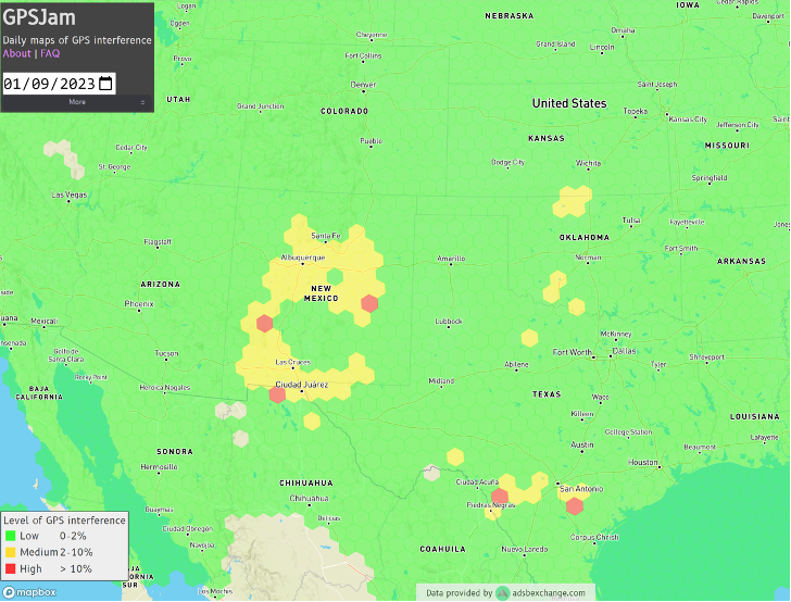
Ever since it came on-line in February 2022, the website GPSJam.org has shown what appears to be regular interference with GPS signals in Texas near San Antonio and Del Rio, and locations north and south of Oklahoma City, Oklahoma.
Only on normal workdays, however. Not on weekends or holidays. Furthermore, whatever was happening also took time off between the Christmas and New Year holidays GPSJam.org also shows similar, though less regular, activity in New Mexico. Experts say this is easily explained as White Sands Missile Range is often the site of electronic warfare training and tests. These are always announced in advance in FAA Notices to Air Missions (NOTAMs) when any interference with GPS reception is anticipated.
The regular patterns observed in Texas and Oklahoma and the lack of NOTAMs led some experts to speculate the source could be inadvertent interference from a commercial or government activity. Said one former official, “It’s just the kind of pattern you see from large organizations. They are off every weekend, federal holidays, and around Christmas.”
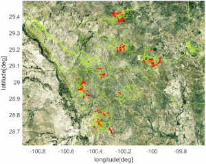
Aerobatic-capable Military Training aircraft reporting low NIC values (Image: Stanford University)
GPSJam.org is the brainchild of aviation analyst John Wiseman. The site uses crowdsourced ADS-B reports gathered by the ADS-B Exchange and displays it on a world map. Areas in yellow indicate that between two and ten percent of ADS-B reports for the day had low navigation accuracy. Areas in red had ten percent or more.
Information from the site has proved useful in identifying patterns of regular GPS jamming and spoofing in Russia and other conflict areas around the globe.
The workday patterns in Texas and Oklahoma have appeared on GPSJam.org displays since the site went live in February 2022.
GPS Interference and Aviation
Minor interference with GPS signals is fairly common. GPS jamming devices, while illegal to use, are inexpensive and easy to obtain from vendors on the internet.
Truck drivers wanting to defeat their company’s fleet tracking system, people concerned about being tracked by the government or others, even ministers trying to keep parishioners from texting during sermons – all have been known to use such devices.
Most GPS interference is unintentional. A two-year European Union study found hundreds of thousands of potentially harmful signals, but judged only about ten percent to be intentional. The rest were the inadvertent byproduct of poorly tuned electrical and electronic equipment.
ADS-B tracks of training aircraft performing aerobatics. Red indicates low NIC value reported. (Image: Stanford University)
While most GPS interference is unintentional and localized, spurious signals powerful enough to noticeably impact airborne operations are not unknown.
In two separate incidents last year strong interference near the Denver and Dallas airports impacted air traffic, each for more than a day. The Denver incident lasted for 33 hours before authorities found the source and shut it down. Air traffic was disrupted at Dallas for 44 hours according to government sources, though researchers found the actual interference only lasted for 24 hours. The source of the disruption was never identified.
In 2019 a passenger aircraft was almost lost due to GPS interference while on approach to Sun Valley, Idaho’s Friedman Memorial Airport. As the aircraft flew a GPS-based approach in smoke and haze, the interfering signal was just strong enough to lure it off course and toward a mountain. Fortunately, a sharp-eyed radar controller hundreds of miles away spotted the problem and intervened in time. The source of the interference was never identified.
As a result of the Sun Valley incident and input from numerous aviation groups, the International Civil Aviation Organization told its members there was an “urgent need to address harmful interferences” to satnav signals.
Texas and Oklahoma Mystery Solved
A researcher at Stanford University finally solved the puzzle of the strange recurring sequence of reports from Texas and Oklahoma.
While investigating last October’s GPS interference event near the Dallas airport, PhD candidate Zixi Liu noticed aircraft outside the main area of effect also reporting low Navigation Integrity Category (NIC) values. This began before and continued after complaints from commercial airlines about GPS not being available at Dallas-Fort Worth. These aircraft were in the same general area of Texas, but far enough away that there were large areas between them and Dallas that did not contain any reports with low NIC values.
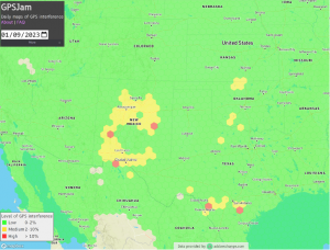
Low navigation accuracy reports displayed at GPSJam.org. in New Mexico reports were due to GPS interference from military testing. In Texas and Oklahoma, military aerobatics training likely caused reports of low navigation accuracy. (Image: GPSJam.org)
At the same time MS Liu was also investigating anomalous ADS-B reports near San Antonio and Del Rio, Texas. She discovered in all three cases the reports of low NIC values were coming from military training aircraft regularly used for aerobatics. Other aircraft nearby reported good NIC values and showed no evidence interference.
In a recent presentation to the Institute of Navigation, she postulated that Interference with GPS signals was not the cause of the low navigation integrity reports. Rather, the rapid maneuvers and unusual aircraft attitudes of aerobatics caused the airplanes’ navigation receivers to intermittently lose lock on signals from GPS satellites. This caused their ADS-B equipment to report low navigation integrity.
Having solved that mystery, Ms. Liu continues to work on her original question – identifying the source of October’s 24-hour GPS disruption near the Dallas-Fort Worth airport.
Mr. Dana A. Goward is the President of the Resilient Navigation and Timing Foundation and a former US Coast Guard helicopter pilot.
“Addresses are created by local address authorities in city, county, and tribal agencies,” explained NSGIC Executive Director Molly Schar. “The data support delivery of services like utilities and emergency response, so getting it right is absolutely critical. NSGIC advocates the process of rolling up local address point records to the state to aggregate and then to the national level to save lives, reduce costs, avoid duplication, increase revenues, improve service and foster efficient and effective government.”
The roll-up process is at the heart of an effort led by the U.S. Department of Transportation and supported by NSGIC to develop a National Address Database. Only 23 states have provided statewide address data to the national database, with five states providing partial data, and three states in the queue.
For this publication, NSGIC tapped state geospatial information officers in Kansas, Massachusetts, Minnesota, New Mexico, New York, Utah and Vermont to identify key factors to the successful organization and coordination necessary to create and maintain strong address programs. These honor roll states scored in the top of the country in the area of address data in NSGIC’s 2019 Geospatial Maturity Assessment (GMA).
NSGIC recently finalized an interactive GMA geospatial web map application with dashboards customized for each data theme allows users to take a deeper dive into the 2019 results, interacting with individual state and collective national results to bring to life the visual patterns and trends in the data.
Geospatial data dashboards have become much more familiar to the public in recent months as most states and municipalities have adopted the interactive platforms to transparently display coronavirus information.
Launched in 2009 to document geospatial development practices and uses, the GMA has provided a biennial snapshot of each state’s geospatial maturity. Inspired by the National Spatial Data Infrastructure theme grading undertaken by the Coalition of Geospatial Organizations (of which NSGIC is a founding member), an entirely new process was developed for the 2019 GMA.
Nine-grade “report cards” were produced for individual state spatial data infrastructures and state geospatial coordination, in addition to overall theme and topical analysis.
Over the next 18 months, additional focused guidance will be issued in the areas of overall statewide coordination and the key datasets for next generation 9-1-1, transportation, parcels, hydrography, elevation, and orthoimagery.
“Collaboration, transparency, and increased efficiency in government are hallmarks of mature state GIS programs,” Schar said. “Through the Geospatial Maturity Assessment research and products, NSGIC is helping states set goals, identify opportunities for collaboration, shine a light on areas requiring attention, and build resources.”


 A report issued by the