Tag: New Zealand

  • Automated shipping moves containers with Locata

    Automated shipping moves containers with Locata

    At ION GNSS+ in September, I met with Nunzio Gambale and Paul Benshoeff of Locata. They were excited to share their news about the timing tests conducted at White Sands Missile Range by the U.S. Air Force’s 746th Test Squadron.

    In the January issue, we share the results of the tests. The two also showed me and Matteo Luccio, our contributing editor, a YouTube video highlighting another Locata project: guiding 100-ton robots around the Ports of Auckland, New Zealand.

    The robots are straddle carriers, giant mechanisms that are usually driven by a human. The carriers move and sort the shipping containers as they arrive from ships and leave via truck or train.

    In the new setup, Locata has made possible the elimination of the human element with nanosecond-precision tracking.

    Tom Scott, a former Sky One television host and now host of a series of YouTube shows, highlighted the robotic system in April 2019 on his “Amazing Places” channel.

    Screenshot: Tom Scott video
    Screenshot: Tom Scott video

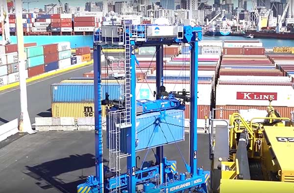
    Compared to manned straddle carriers, the automated straddle carriers (A-STRADs) are able to stack the containers closer, higher and work more steadily, increasing the capacity of the limited land space at the port. The A-STRADs can stack containers with the accuracy of a few centimeters.

    The automated system also allows stack shuffling, so that wear and tear on the asphalt is spread more evenly and requires fewer repairs.

    The Locata local positioning system uses synchronized transmitters installed around the port, with two antennas on each straddle carrier using the lightspeed delay from each transmitter to find exact position. “They don’t just look at the timing signal itself, they track the phase of each transmitter’s carrier signal,” Scott explained.

  • Trimble acquisitions increase VRS network in Canada, New Zealand

    Trimble acquisitions increase VRS network in Canada, New Zealand

    Photo: Trimble
    Photo: Trimble

    Trimble has acquired Cansel Survey Equipment’s Can-Net and AllTerra New Zealand’s iBase networks. The acquisitions significantly increase the global footprint of Trimble-owned Virtual Reference Station (VRS) networks by adding key geographies in North America and New Zealand.

    Subscription-based VRS correction services are now accessible to more customers around the world who rely on high-accuracy corrections to increase productivity and reduce operational costs. The correction services are designed for professionals in agriculture, geospatial and construction as well as emerging high-accuracy applications, such as on-road positioning for passenger vehicles. Financial terms were not disclosed.

    The Can-Net and iBase acquisitions add over 1.1 million square kilometers (over 425,000 square miles) to Trimble’s correction services coverage that has grown robustly over the past eight years, contributing to Trimble’s shift toward software, services and subscription business emphasis.

    Can-Net Network. The Can-Net network comprises multiple VRS networks and single-base solutions offering GNSS corrections across Canada. The acquisition provides Trimble with the largest VRS footprint in Canada, covering more than one million square kilometers (386,000 square miles).

    Subscribers primarily work in the agriculture, survey and construction industries. In addition, the Can-Net network enables Trimble corrections technology to be used by automotive stakeholders deploying ADAS systems along the Trans-Canadian Highway.

    iBase Network. The iBase network expands Trimble’s VRS footprint across both the north and south islands of New Zealand, totaling more than 100,000 square kilometers (39,000 square miles).

    “The high-accuracy precision provided by VRS technology is a powerful tool in driving operational and financial efficiency for industries that require easy access to positioning services,” said Patricia Boothe, vice president of Trimble’s Advanced Positioning Division. “We are aggressively expanding the accessibility of VRS corrections around the globe. Our vision is to make high-accuracy positioning available to the broadest base of commercial users worldwide for applications in agriculture, construction, automotive, autonomy and others where precise positioning is a critical part of the solution. Trimble will continue to invest in technology and infrastructure to push the boundaries of performance and accessibility for our portfolio of services.”

    Trimble networks are supported by a global network operations team made up of GNSS system engineers, geodesy experts and IT professionals. The team monitors the networks 24/7 from operation centers located on three continents, ensuring consistent and reliable service uptime and performance integrity.

  • Seen & Heard: Microsatellites, tethered drones and ladybugs

    “Seen & Heard” is a monthly feature of GPS World magazine, traveling the world to capture interesting and unusual news stories involving the GNSS/PNT industry.

    Tethered drone

    Spanish police used a tethered drone system for traffic monitoring, crowd control and surveillance of the UEFA Champions League Final, played June 1 at the Wanda Metropolitano stadium in Madrid. An Elistair tethered U06 Plus drone oversaw 67,000 fans in the stadium and 200,000 in nearby streets. Use of the drone was in response to a heightened terrorist threat level in Spain, making it part of the largest security operation for any sporting event in the Spanish capital. Continuously supplied with power, the drone maintained its position at 50 meters high for 8 hours.

    CYGNSS satellite launch. (Artist’s concept/NASA)
    CYGNSS satellite launch. (Artist’s concept/NASA)

    Tricky Signals

    NASA’s eight CYGNSS (Cyclone Global Navigation Satellite System) microsatellites collect radio signals from GPS beacons to characterize hurricanes. A month after launch in December 2016, the CYGNSS team noticed the signals were wavering when the U.S. began to boost the radio power on 10 GPS satellites as they passed over northern Syria. The swings don’t interfere with other scientific uses of GPS, but for CYGNSS the measurements of high winds varied by 5 meters a second or more — the difference between a category-2 and category-3 hurricane. After two years of work, the CYGNSS team has compensated by repurposing a secondary antenna on the satellites to measure GPS signal strength.

    The ladybug blob tracked by Doppler radar. (Image: National Weather Service)
    The ladybug blob tracked by Doppler radar. (Image: National Weather Service)

    Ladybug, ladybug, fly away home

    In this case, California. In June, a millions-strong swarm of ladybugs showed up on radar as a weather event when the insects took to the sky to hunt for aphids. One explanation for the unusual swarm is that a large population of ladybugs had been spread out in a mountainous area, and rising temperatures triggered their mass migration to valleys where they might find an abundance of aphids to eat.

    New Zealand joins Aussies on SBAS

    Land Information New Zealand (LINZ) will work with Australian counterpart Geoscience Australia to investigate ways to deliver a regional satellite-based augmentation system (SBAS) to significantly improve GPS accuracy. The proposed SBAS will support emergency helicopter crews, providing pilots with accurate vertical guidance for landing, enabling them to reach people faster in difficult terrain and bad weather. The SBAS will also improve the safety of self-driving cars. The new system will improve accuracy to less than a meter, and in some devices to 10 centimeters.

  • University research uses smartphones for precision GNSS

    New research conducted at the University of Otago, New Zealand, and published in the August issue of Journal of Geodesy demonstrate that it is possible to achieve centimeter(cm)-level precise positioning on a smartphone.

    The research, conducted in collaboration with Curtin University, Australia, combined signals from four different GNSS, according to Otago’s Dr. Robert Odolinski and Curtin University colleague Prof. Peter Teunissen.

    “It’s all down to the mathematics we applied to make the most of the relatively low-cost technology smartphones use to receive GNSS signals, combining data from American, Chinese, Japanese and European GNSS. We believe this new capability will revolutionize applications that require cm-level positioning,” Odolinski says.

    He said to understand the new technology, a look back at the historical scientific context is needed.

    Precise centimeter-level positioning on a smartphone during 24 hours in Dunedin, New Zealand. Blue dots show repeatability of one epoch data in comparison to precise benchmark coordinates. The repeatability is more or less the size of a one-dollar New Zealand coin (diameter of 2.3 cm) in all three dimensions. (Image: University of Otago)
    Precise centimeter-level positioning on a smartphone during 24 hours in Dunedin, New Zealand. Blue dots show repeatability of one epoch data in comparison to precise benchmark coordinates. The repeatability is more or less the size of a one-dollar New Zealand coin (diameter of 2.3 cm) in all three dimensions. (Image: University of Otago)

    “For decades, construction, engineering, cadastral surveying and earthquake monitoring have relied on high-cost, dual-frequency GPS positioning to obtain centimeter-level location information. The challenge is that GPS signals, traveling from Earth-orbiting satellites to receivers on the ground, are disrupted along the way, and this generates errors and limiting precision.

    “The traditional solution is to combine GPS signals sent at two different frequencies to improve the positions, but the antennas and receivers required have been expensive, far beyond the reach of many who would benefit from the technology,” Odolinski said.

    The new approach uses only one of two frequencies but collects data from more satellites for a multi-constellation GNSS solution. The extra data and algorithms are used to improve the positions without adding cost.

    Odolinski and Teunissen have shown that this approach can work in smartphones, producing competitive results compared to dual-frequency GPS solutions (see figure).

    Odolinski believes that countries and industries of all sizes can benefit from using smartphones as GNSS receivers, and is confident commercial application and development will spring from this research.

    “This significant reduction in costs when using smartphones can increase the number of receivers that can be deployed, which will revolutionize a range of disciplines requiring centimeter-level positioning, including precise car navigation, surveying and geophysics (deformation monitoring), to name a few.”

    Read the full research paper.

    Robert Odolinski configuries a smartphone to collect multi-GNSS data. (Photo: University of Otago)
    Robert Odolinski configuries a smartphone to collect multi-GNSS data. (Photo: University of Otago)
  • Fugro’s airborne tech surveying after New Zealand earthquake

    Fugro’s airborne tech surveying after New Zealand earthquake

    Fugro’s laser airborne depth sounder (LADS) technology is being deployed in New Zealand to assist in relief efforts following the damaging 7.9 magnitude earthquake near Christchurch on Nov. 14.

    At the request of the New Zealand Government, the Royal Australian Navy LADS flight is to conduct a rapid hydrographic survey of the seafloor in the coastal margins of the north east coast of the South Island.

    “We will fly over the area and collect hydrographic survey data, which will reveal what has happened below the waterline, and identify any shifts in the ocean floor which mariners need to be aware of,” explained Flight Lieutenant Commander Susanna Hung, who is serving as the mission’s commanding officer.

    The navy’s airborne lidar bathymetry (ALB) system has been developed by Fugro for safe, high speed and cost effective surveys of shallow coastal areas. Under a long-term contract to the RAN, Fugro provides the LADS technology, a de Havilland Dash 8-202 aircraft and support services.

    Fugro's LADS technology is being deployed following the Nov. 14 New Zealand earthquake.
    Fugro’s LADS technology is being deployed following the Nov. 14 New Zealand earthquake.

    The airborne survey equipment is operated by navy personnel from the main cabin of the aircraft to rapidly collect high resolution data of the seafloor. Fugro’s system incorporates sophisticated sensors that utilize a high-powered laser, innovative scanner and receiver optics technology.

    The survey tool complements traditional hydrographic survey methods (such as hull-mounted multibeam echo sounders) to support nautical charting and coastal zone management applications in the nearshore/shallow water environment. The speed of deployment and safe operating capability make it an ideal solution to confirm the safety of navigation and locate new hazards such as is now required in the earthquake affected area.

    “The New Zealand deployment by RAN LADS is an excellent example of how our innovative technology can assist in the safety of navigation and management of the marine environment,” said Paul Seaton, Fugro’s regional business development manager.

  • New Zealand Navy gets navigation upgrade

    Northrop Grumman has been selected by the New Zealand Ministry of Defence to provide navigation suite upgrades to the two Royal New Zealand Navy’s ANZAC Class Frigates.

    The suites will replace existing MK49 inertial navigation units with fourth-generation MK39s.

    The new units feature an embedded data distribution system, reduced weight and size, and autoselect features that ensure the highest quality data is made available to the ship.

    Data distribution capabilities include secure network communications capable of transmitting time-corrected data with low senescence to significantly improve the warfighter’s ability to react to potential threats and increase safety at sea.

  • McMurdo Completes MEOSAR Ground Station in New Zealand

    McMurdo Completes MEOSAR Ground Station in New Zealand

    MEOSAR ground station in New Zealand.
    MEOSAR ground station in New Zealand.

    Emergency readiness and response company McMurdo has completed the installation of a six-antenna next-generation Medium-Earth Orbit Search and Rescue (MEOSAR) satellite ground station system in New Zealand.

    The project, which is part of a joint initiative with Maritime New Zealand and the Australian Maritime Safety Authority, is expected to significantly boost search-and-rescue capability in the New Zealand and Australia search regions and marks the first implementation of MEOSAR in Asia Pacific.

    MEOSAR is the next-generation version of Cospas-Sarsat, the international search-and-rescue satellite system that has helped to save 37,000 lives since 1982. Cospas-Sarsat is in the process of upgrading its satellite system by placing search-and-rescue transponders on new GPS, GLONASS and Galileo satellites. Once qualified as operational, this system augmentation will dramatically improve both the speed and location-accuracy for detecting beacons.

    In a typical satellite-based search-and-rescue scenario, ships, aircraft or individuals transmit distress signals from an emergency location beacon via satellite to a fixed ground receiving station or local user terminal. The ground station receives and calculates the location of the distress signal and creates and sends an alert to the appropriate rescue authorities. Today, the beacon-to-alert process depends on a limited number of low Earth orbit (LEO) satellites and may take several hours before a position is confirmed. With MEOSAR, beacon signals will be received more quickly and beacon locations identified with greater accuracy thereby reducing this time to minutes.

    “Beacons can take the ‘search’ out of search and rescue, and the MEOSAR system will dramatically increase the global search-and-rescue capability,” said Maritime New Zealand Director Keith Manch. “Emergency distress beacons are key equipment for anyone operating at sea, on land and in the air – whether commercially or recreationally — but they can’t operate without sites like this.”

    “This key installation firmly establishes McMurdo as the premier MEOSAR infrastructure provider globally,” said Remi Julien, McMurdo president. “We are committed to partnering with both Maritime New Zealand and the Australia Maritime Safety Authority to ensure that they have the technology, training and long-term support in place to significantly reduce search-and-rescue times and, ultimately, save more lives today and in the future.”

    The New Zealand MEOSAR system, and another being installed in Western Australia, will cover one of the largest search-and-rescue areas in the world — from north of Australia/New Zealand to the Equator and south to the South Pole, east to half way across the Pacific, and west half way across the Indian Ocean. The systems will undergo rigorous testing before being officially brought online in late 2017 by Cospas-Sarsat.

    There are 58,000 emergency distress beacons registered in New Zealand which, without any changes or updates, will be immediately usable by the new systems. It is estimated, however, that an additional 25,000 beacons are unregistered. Due to the high responsiveness of the MEOSAR system, search-and-rescue authorities strongly recommend beacon registration. This will help the unnecessary deployment of search-and-rescue resources due to inadvertent beacon activations. The Rescue Co-ordination Centre New Zealand, part of Maritime New Zealand, responds to 550 beacon alerts a year.

  • Tallysman GPS/GNSS Antennas Available in Australia, New Zealand

    Tallysman GPS/GNSS Antennas Available in Australia, New Zealand

    TW4421 wideband dual-feed GPS/GLONASS antenna.
    TW4421 wideband dual-feed GPS/GLONASS antenna.

    Two dual-feed GPS/GLONASS antennas from Tallysman’s GNSS antenna range are now available in Australia and New Zealand through M2M Connectivity. Tallysman is a Canada-based developer of high-performance GNSS antennas focused on the requirements for precision and multi-constellation GNSS receivers.

    Featuring a dual-feed wide-band patch element, Tallysman’s TW2410 and TW4421 antennas cover the GPS L1, GLONASS G1 and SBAS (WAAS, EGNOS and MSAS) frequency band (1574 to 1606 MHz). The dual-feed patch provides excellent circular polarized signal reception, multipath rejection and out-of-band signal rejection, according to Tallysman.

    Offering tight phase center variation (PCV), the antennas are suitable for high-accuracy applications and for use in precise point positioning (PPP) systems that require only a single frequency such as single-frequency RTK solutions, GNSS compasses and machine control.

    Suitable for precision industrial, agricultural and military applications, the dual-feed GPS/GLONASS antennas feature Tallysman’s Accutenna technology that provides superior or multipath signal rejection and precision. The TW2410 and TW4421 antennas are housed in IP67 industrial-grade weather-proof, magnet mount enclosures and come with a wide range of connector options and cable lengths.

    Tallysman is a manufacturer of high-performance, high-quality products for a wide range of GNSS applications.