uAvionix has received approval by the Federal Aviation Administration (FAA) to conduct beyond-visual-line-of-sight (BVLOS) small unmanned aerial flight in North Dakota. The test flight to secure approval took place at the Northern Plains UAS Test Site in North Dakota.
Vantis is North Dakota’s UAS network, which serves many UAS operators across different sectors. By leveraging Vantis, uAvionix demonstrated to the FAA it had established adequate risk mitigations to satisfy required safety standards for BVLOS operation within the national airspace system.
The Northern Plains UAS Test Site partnered with Thales USA to develop and implement Vantis. The UAS system enables UAS pilots to command and control the UAS and remain clear of other aircraft when flying BVLOS. Vantis includes ground-based aviation infrastructure, which lowers the barrier of entry to BVLOS flights for multiple users.
The FAA approval to conduct BVLOS UAS flights is another step in bringing UAS to commercial sectors. UAvionix continues to collaborate with FAA as regulations evolve to ensure Vantis meets all necessary requirements.
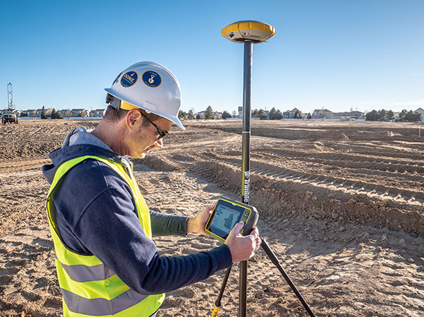
Trimble continues to increase its footprint to deliver high-accuracy positioning correction services
Photo: Trimble
Trimble has acquired MidStates VRS, a network previously owned by Butler Machinery and Frontier Precision. The addition of the network, in North and South Dakota, increases the footprint of Trimble’s VRS Now GNSS corrections service to cover more than one million square miles in North America. Financial terms were not disclosed.
As part of an ongoing expansion strategy, the new coverage for the VRS Now subscription service helps users in more places achieve high-accuracy positioning to increase productivity, reduce operational costs and improve safety.
The correction service is designed for professionals in agriculture, geospatial and construction as well as emerging autonomous applications including lane-keeping for passenger vehicles, vehicle-to-everything (V2X) position identification and unmanned aerial system guidance.
Adding 105,000 square miles of coverage, the acquisition expands Trimble’s VRS Now network to be one of the largest in North America — over one million square miles, contributing to Trimble’s shift toward a software, services and subscription business emphasis.
When using the Trimble VRS Now service, land and construction surveyors, GIS professionals and farmers — with a Trimble or third-party commercial GNSS receiver — can leverage instant high-accuracy corrections delivered via cellular network to improve productivity.
Enabling users to work without a GNSS base station, the service is cost-effective and simple to use. It is ideal for a variety of applications that require sub-inch level accuracy and is an important component of the connected construction site and connected farm workflows.
“The MidStates VRS network covers significant farmland, oil fields and rapidly developing urban areas, providing farmers and surveyors in the region with the real-time GNSS correction services they need to improve their day-to-day work,” said Patricia Boothe, senior vice president of Trimble’s Autonomy Sector. “The purchase of the MidStates network demonstrates Trimble’s ongoing commitment to provide a wide range of correction services for autonomous solutions — delivering unmatched access to fast, reliable and highly accurate positioning in more areas than ever before.”
Trimble networks are supported by a global network operations team made up of GNSS system engineers, geodesy experts and IT professionals. The team monitors the networks 24/7 from operation centers located on three continents, providing consistent and reliable service uptime and performance integrity.
Trimble VRS Now. The correction service offers instant access to centimeter-level positioning tailored to the users’ geographic location; the service is always on wherever and whenever needed within the network coverage area. With no base station or setup required, it is cost-effective, efficient and simple to use.
VRS provides positioning professionals with instant access to real-time kinematic (RTK) and post-processing (PP) corrections utilizing a network of permanent (fixed) continuously operating reference stations (CORS).
Trimble-owned VRS networks are accessible now in areas throughout the U.S. and Canada as well as Eastern Australia and Tasmania, France, Belgium, the Czech Republic, Estonia, Germany, Great Britain, Ireland, Luxembourg, the Netherlands, Sweden and New Zealand.
The new US Topo maps for North Dakota (1,402 maps), Delaware (38 maps) and Maryland (213 maps) have been posted to the USGS Map Locator & Downloader and are also accessible through The National Map viewer.
The new maps feature a design that was launched earlier this year and replace the first edition US Topo maps for those states. The new design presents a crisper and cleaner presentation, which enhances the readability of the maps for online and printer use.