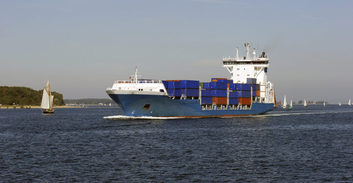
The Coastal States of the Baltic Sea and the North Sea have published an open letter to the international maritime community insisting on the protection of GNSS-based navigtion. The countries point the finger squarely at the Russian Federation for causing disruption in both critical navigation and timing services for sea vessels.
“Modern maritime transport is fundamentally built on the reliability of satellite-based navigation,” reads the letter. “For over three decades, global shipping has advanced by developing vessel operations to increasingly depend on the position, timing and navigation data provided by satellite systems. This shift has brought great efficiency but has also created a new dependency.
The letter highlights the importance of GNSS as a critical safety requirement, not only ship navigation but also precise time synchronization vital for systems such as the Global Maritime Distress and Safety System (GMDSS).
Risks to the Automatic Identification System
Another GNSS service, the Automatic Identification System (AIS), plays a key role in traffic coordination, situational awareness and emergency response. “Spoofing or falsifying AIS data undermines maritime safety and security, increases the risk of accidents, and severely hampers rescue operations,” the letter states.
“We are now facing new emerging safety situations due to growing GNSS interference in European waters, particularly in the Baltic Sea region. These disturbances, originating from the Russian Federation, degrade the safety of international shipping. All vessels are at risk.”
The countries ask for cooperation developing alternative terrestrial radionavigation systems as a GNSS backup. They also want vessels crews properly trained to operate safely during navigation system outages.
“Maintaining trust in maritime navigation requires more than technology – it demands responsibility, transparency, and decisive action,” the letter states. “We must ensure that our seas remain safe, including when systems fail or face disturbances.”
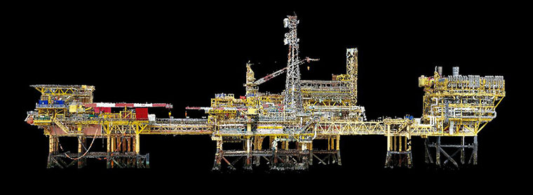
Terra Drone Europe, a group company of Terra Drone Corporation, has completed an aerial 3D survey and produced a 3D model of an offshore oil rig platform in the North Sea for Shell.
According to Terra Drone Europe, the platform complex that was surveyed was positioned several years ago when GNSS survey techniques were neither very advanced nor common. Several coordinates were known and as-build drawings were available, but Shell wanted to know the position of each and every element on the platform to facilitate accurate drill rig positioning.
Terra Drone Europe completed an aerial 3D survey and produced a 3D model of an offshore oil rig platform in the North Sea for Shell. (Photo: Terra Drone)
Thus, the company recruited Terra Drone Europe to capture the as-is conditions through a high-precision oil rig platform survey. According to Terra Drone, the survey was divided into two parts: one part dedicated to creating a 3D point cloud and the second to accurately check the position of the platform using GNSS readings.
Two GNSS receivers were installed at several different locations on each platform and used to log in the raw data which was later processed. When this data was combined with the 3D point cloud created by Terra Drone Europe, the coordinates of each asset on the platform structure were determined.
Terra Drone Corporation recently established new branches focusing on the oil and gas sector in Argentina, Angola, Kazakhstan and the United Arab Emirates. The company also formed a new branch to provide advanced nondestructive testing and inspection services to the oil and gas industry.
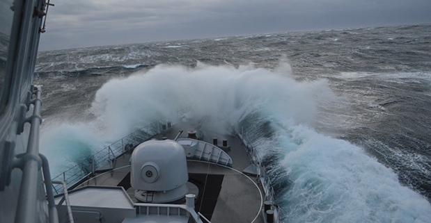
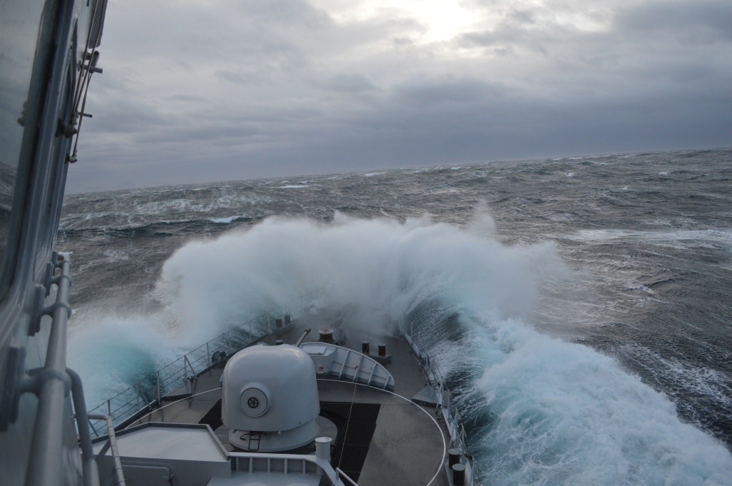
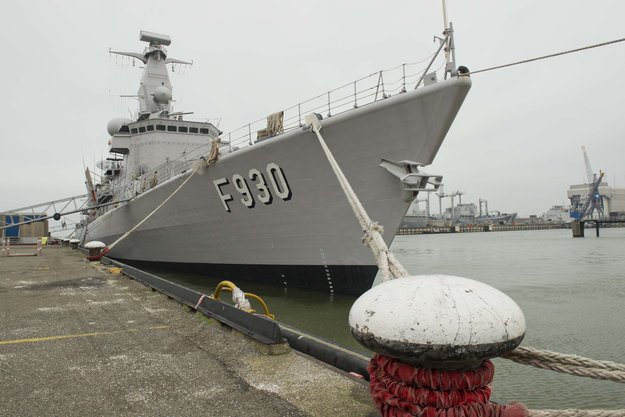
Belgian frigate Leopold I-F930 in rough water off Norway during Galileo maritime testing. In December 2013 the frigate participated in the first maritime trials outside mainland Europe of the Galileo satellite navigation system.
Results are being processed from the first Galileo maritime trials outside of mainland Europe. The long-range, high-latitude testing spanned the North Sea, following the same historical sailing route that Viking dragon-ships used 1200 years ago.
Ancient manuscripts record Viking navigators relied on “sunstones” to find their way — archaeologists believe these may have been polarizing crystals to pinpoint the Sun even in overcast skies.
By contrast, Belgian frigate Leopold I-F930, participating in the end-of-year trials, carried the most up-to-date equipment possible, with multiple Galileo receivers for both its public Open Service (OS) and secure Public Regulated Service (PRS).
“Galileo is in a transition between its In-Orbit Validation (IOV) phase and follow-on Full Operational Capability phase,” said Miguel Manteiga Bautista, head of ESA’s GNSS Security Office. “This means we are engaging in all kinds of experimental demonstrations of all Galileo services, in particular PRS, which offers the most highly accurate positioning and timing performance, but with access strictly restricted to authorized users.”
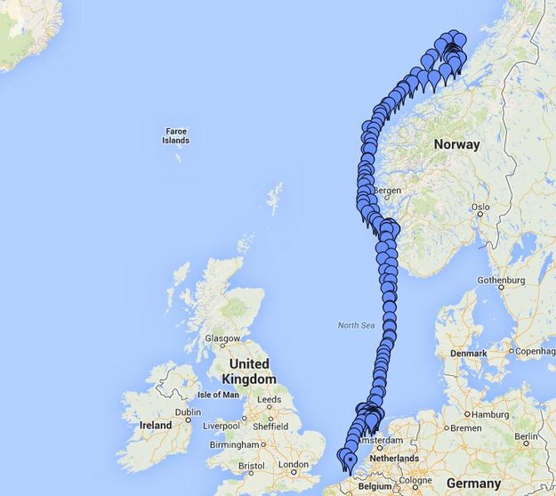
The recorded course of Belgian frigate Leopold I-F930 during the first high-latitude trials of Europe’s Galileo satellite navigation system. The frigate sailed first from the Dutch marine base of Den Helder on 4 December 2013 to Stavanger in Norway. From there it progressed north in very rough seas with 10-m high waves, coming close to the Arctic circle on December 17 — a first for Galileo PRS observations — before heading homeward.
The frigate sailed first from the Dutch marine base of Den Helder on December 4, 2013, to Stavanger in Norway. From there it progressed north in very rough seas with 10-meter-high waves, coming close to the Arctic circle on December 17 — a first for Galileo PRS observations — before heading home.
The testing provided tangible in-situ evidence of Galileo signal stability across both its operating frequencies up at high latitudes, equaling low satellite elevations in the local sky.
Following the completion of earlier road, then flight, testing last summer and autumn, the last challenge for Galileo’s IOV phase was to engage in a long-term maritime trial into high latitudes. The testing was performed as part of the PRS Participants to IOV project jointly managed by ESA and the European Commission, in collaboration with the European GNSS Office Agency and several Member States possessing PRS test receiver technology.
The trials were performed by the Royal Military Academy of the Belgian Ministry of Defence, the UK Space Agency in collaboration with Nottingham Scientific Ltd. and ESA, to ensure PRS signals were available whenever the four Galileo satellites in orbit came into view.
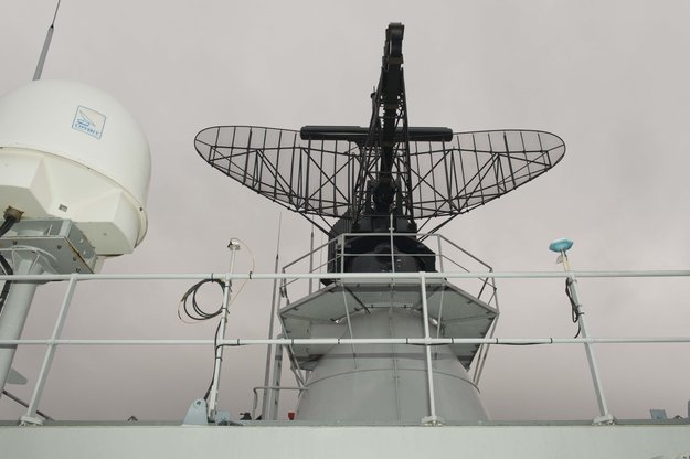
Two receivers, seen either side of the main antenna, were carried by Belgian frigate Leopold I-F930 during high-latitude testing of both Galileo’s publicly-available Open Service and secure Public Regulated Service in December 2013.
A dual-test setup was fitted to the frigate at Den Helder. Belgium connected a PRS receiver and an OS receiver, both manufactured in Belgium by Septentrio NV, to a common antenna. The PRS receiver recorded raw PRS measurements on both frequencies while the OS receiver logged data from openly available Galileo, GPS and GLONASS signals at one-second intervals.
Nottingham Scientific installed its Ultra system configured to record radio-frequency samples, allowing the detailed post-processing of Galileo OS and PRS signals.
“As this was a first use of PRS equipment outside EU borders, the security issues were quite challenging,” said Bruno Vermeire, head of the Belgium Competent PRS Authority (Federal Public Service of Foreign Affairs). “Several partners from different countries and industries were involved. At all times the necessary security was assured, though this could not have been possible without the dedicated joint commitment of all partners.”
David Parker, head of the UK Space Agency, commented, “This test is a significant milestone on the road to demonstrating early PRS capability across a range of platforms. It should serve as a model for wider international collaboration between national governments and industry to prove and demonstrate PRS in different applications.”
Belgian frigate Leopold I-F930 at Den Helder dockyard in the Netherlands.
Alain Muls, professor of the Royal Military Academy of Belgium, faced the challenge of coordinating the maritime trial without interfering with the normal operations of the frigate. “Thanks to the cooperation of with the Maritime Component of the Belgium Defence, in particular that of the frigate’s commander and crew, preliminary results look very promising. Reception of Galileo’s OS and PRS navigation services have been practically demonstrated under severe maritime conditions with waves of up to 10 meters in height.”
“This activity is a truly collaborative effort at all levels. The trial involved UK and Belgian governments and industry partners with support from different European bodies as well as officials from the Netherlands and Norway,” said Mark Dumville, Nottingham Scientific general manager. “This team effort has enabled the concept of radio-frequency sampling processing of Galileo PRS signals to be tested in real-world operational environments. We have confirmed that the prototype receiver is now ready to support European governments and associated PRS applications.”
The collaborative nature of this trial was formally recognized as the Leopold I-F930 reached Stavenger. Under the supervision of Belgium’s CPA, Jochen Devadder, the country’s Ambassador to Norway Michel Godfrind provided a Norwegian delegation with details of the testing.
Results from the trial will guide future Galileo developments for years to come.
What is expected to be a first annual conference of the ACCSEAS (Accessibility for Shipping, Efficiency Advantages and Sustainability) project will examine how to address significant current and future issues which may impact on safe navigation in the North Sea and western Baltic Sea by pioneering safe regional access through the use of e-Navigation.
Themes for the March 2013 Conference will include:
Defining regional e-Navigation for safe and efficient access to ports in the North Sea;
Providing an innovative approach to North Sea accessibility and efficiency challenges; and
The use of e-Navigation as a sustainable way forward for improving navigational safety within our region.
A recent ACCSEAS project workshop in the Netherlands in December 2012, which was attended by representatives from major North Sea ports, well known shipping companies, navigation authorities and equipment suppliers, identified significant issues which may interfere with safe navigation in the North Sea and the neighbouring area of the Western Baltic.
The issues identified by the workshop that can be further explored within the conference included:
Implications of renewable power generation, particularly the proliferation of wind turbines and potential reductions in navigable “sea room”;
The prediction that an increase in ship size, particularly amongst container vessels, is unlikely to reduce shipping traffic densities;
The need to recognise the complexity of bridge systems in the training of seafarers;
Questioning by mariners of their trust in the accuracy of existing onboard navigation systems;
Provision of a navigational back-up in the event of failures, jamming or “spoofing” of vulnerable satellite based systems;
Identifying the need to provide better links between mariners and policy makers at national, European and International levels;
Better provision of information between ship and shore personnel, particularly with respect to routing and weather information.
The conference will also include the establishment of the first North Sea e-Navigation Forum to bring together users, stakeholders and navigation authorities and provide a voluntary arena for discussing and advising on the future implementation of e-Navigation in the region.
The ACCSEAS Project, which seeks to improve maritime access to the North Sea Region of Europe, is run by a partnership of navigation and maritime authorities, academic institutions and industry from Denmark, Germany, Netherlands, Norway, Sweden and United Kingdom.
Within this area, ACCSEAS aims to implement and demonstrate a practical test-bed for e-Navigation prototype services in order to demonstrate proof-of-concept solutions to existing and potential navigation issues within the region.
Commenting on the ACCSEAS Project and the first annual conference, Roger Lockwood, Chief Executive of the Northern Lighthouse Board, stated:
“The ACCSEAS project is an exciting opportunity to put the maritime community at the centre of future innovation in navigation safety for efficient access to North Sea ports.”
Further information and registration details for the conference will shortly be available on the ACCSEAS website.