Tag: NTRSA

  • RNT Foundation proposes attributes for resilient timing RFP

    RNT Foundation proposes attributes for resilient timing RFP

    Image: RNT Foundation
    A National Resilient Timing Architecture should include delivery by fiber and RF along with space-based, according to the RNT Foundation. (Image: RNT Foundation)

    The Resilient Navigation and Timing (RNT) Foundation has published a white paper proposing attributes for a government Request for Proposal (RFP) to acquire timing services.

    A National Resilient Timing Architecture – Now for an RFP!” builds upon the foundation’s October 2020 white paper “A Resilient National Timing Architecture.”

    Timing services, most of which are now sourced directly or indirectly from GPS, are essential for myriads of network, transportation, financial, industrial, and other applications. The National Timing Resilience and Security Act of 2018 (NTRSA) requires establishment of one or more systems to serve as alternatives and back up GPS timing.

    The RNT Foundation’s October 2020 white paper discusses how a national timing architecture fulfilling the requirements of NTRSA could be established relatively easily and inexpensively. It proposes that, rather than building its own system, the government contract for services with commercial providers.

    The new white paper outlines some of the requirements and evaluation criteria the government might use when acquiring timing services.

    Goals

    The paper postulates that the goal of such a procurement should be to establish a federal timing “backbone.” This would fulfill the requirements of NTRSA, which recognizes that timing is critical for many applications and is also the basis for most electronic positioning and navigation systems.

    Establishing this backbone will provide users with an alternative and a safety net for GPS disruptions, and at other times enable more resilient and reliable services. As a backbone, it would provide basic, foundational services upon which others would be able to build. The new services would be expected to:

    • support a wide variety of public and private applications across the nation
    • be entirely independent from and have minimal or no common failure modes with GPS and other GNSS
    • provide multiple and diverse methods of timing delivery
    • serve both fixed and mobile users.

    Regarding this last point, the paper notes that mobile devices must know their location before they can make use of timing signals. Thus, the selected system or combination of systems also will have to provide GPS-independent location information at a basic level to mobile users.

    Requirements

    Successful proposals, the paper envisions, will need to meet a number of requirements including

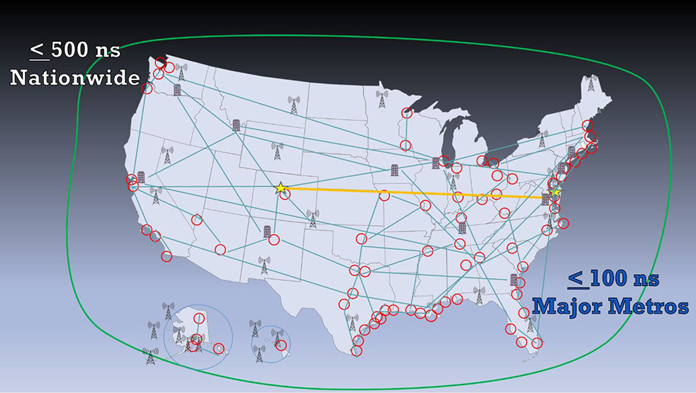
    • serving the entire U.S. land area, airspace, and coastal waters to about 200 miles offshore
    • enabling all fixed and mobile users to access at least one non-space-based source (to ensure no common failure modes with GPS/ GNSS)
    • timing accuracy in all locations to within 500 nanoseconds of universal coordinated time (UTC); this accuracy should be within 100 nanoseconds of UTC for the 50 largest metropolitan areas
    • one or more integrity measures to provide users confidence in system(s) accuracy
    • a very high rate of continuity and availability, similar to that of navigation beacons for aircraft
    • a performance monitoring and control system.

    Evaluation Criteria

    Fortunately for the government, numerous systems and companies are already able to provide the needed services. Deciding which to select will likely be a significant effort. Some of the evaluation criteria suggested by the RNT Foundation white paper are:

    Annual Cost – While cost will not be the only consideration in this acquisition, the government always has a responsibility to taxpayers to weigh it as an important factor.

    Infrastructure Required Per Unit of Coverage Area – This has been cited by the Department of Transportation as a very important consideration. Not only does the amount of infrastructure affect cost, but it also has implications for environmental and community impacts.

    Spectrum – Signal disruption by in-band and out-of-band transmissions has been a significant issue for GPS. New PNT wireless and radio-frequency services should pose as few spectrum concerns as possible. Spectrum band reservations, licenses, pre-allocated bands, other bands and adjacent band uses will all be given consideration.

    Penetration – While the government may not list this as a requirement, the ability of a service to reach underwater, underground and indoor locations will likely be desirable and part of proposal evaluation.

    Resilience – The vulnerability of GPS signals to disruption will undoubtedly make the resilience of potential backup and complementary systems a major issue. The RNT Foundation paper discusses two kinds of resilience – operational and recovery.

    Operational resilience is defined as “the ability of a system, combination of systems, or service to resist disruption (e.g.: jamming, spoofing, physical damage negatively impacting service).” One measure of resilience might be the energy needed to disrupt signals.

    Recovery resilience is described as “The speed and ease with which a service can return to normal operation” after a disruption.

    Cybersecurity – Similarly, cybersecurity is seen as having two components. The first is network security, defined as the degree to which systems are isolated from or connected to networks. Second is signal security, and is how well signals can be protected from infiltration and imitation.

    Endorsements for GPS Alternative Timing

    Since the “National Resilient Timing Architecture” white paper was issued in 2020, calls for GPS alternatives have intensified, and the white paper itself has received an important endorsement.

    On May 7, the telecommunications industry standards group Alliance for Telecommunications Industry Solutions (ATIS) vigorously supported federal funding for GPS alternatives. In letters to leaders in both houses of Congress, ATIS cited “the urgent need for funding the deployment and adoption of Alternative Positioning, Navigation, and Timing (PNT) Systems in U.S. critical infrastructure, including the U.S. telecom industry.”

    The need for federal support for timing and positioning backups for GPS was also supported by a two-year old study released by RAND Corporation in May. While the paper went to great lengths to argue against a duplicate GPS-like capability (something no one has supported to the best of our knowledge), it quietly suggested federal support for both a national timing system and location services to serve E-911 systems.

    Numerous recent media releases from U.S. Space Force have revealed serious military threats to GPS and other space-based systems. A variety of killer-satellites, lasers and other weapons have turned space from a sanctuary into a potential battle ground. While not specifically calling for alternatives to GPS, the Space Force announcements have made it clear the nation needs to “get the bullseye off GPS.” Establishing at least one terrestrial alternative system similar to those operated by our adversaries will make U.S. satellites and signals much less attractive targets, according to Greg Winfree, former assistant secretary at the U.S. Department of Transportation.

    Federal Funding Needed

    Federal funding for improving national timing was specifically supported by a group of CEOs and senior executives from major telecom companies. Acting as the National Security Telecommunications Advisory Committee (NSTAC), the group’s May report to President Biden discussed GPS vulnerabilities and threats, and urged establishment of a capability

    “…similar to that reflected in the Resilient Navigation and Timing Foundation’s paper entitled A Resilient National Timing Architecture. Further, to enhance the ability of commercial entities to afford leveraging this architecture, the Administration should appropriate sufficient funds to lay the foundation for creating this timing architecture, with the Federal Government being the first customer for what will ultimately become a resilient, interconnected network for PNT delivery.”

    Federal funding support is necessary, according to NSTAC, because free GPS services greatly suppress market demand for alternatives.


    Dana Goward is president of the Resilient Navigation and Timing (RNT) Foundation.

  • LORAN-5G: Paper envisions new use for venerable tech

    LORAN-5G: Paper envisions new use for venerable tech

    Image: KENGKAT/iStock/Getty Images Plus/Getty Images
    Image: KENGKAT/iStock/Getty Images Plus/Getty Images

    A new paper by two Qualcomm engineers imagines restructuring Loran technology to more easily incorporate timing signals into telecommunication systems.

    The paper, titled simply “LORAN-5G,” was authored by Guttorm Opshaug and Dave Tuck. It envisions moving away from legacy pulsed signals to a more continuous wave form which would allow significantly lower power transmissions.

    According to Opshaug, “Another big advantage that may not be as apparent, is the built-in orthogonality in the signal structure of OFDM. This means that a receiver would be able to detect very weak signals from distant towers at the same time as receiving signals from a very strong close tower. Such robustness towards near-far effects is critical for terrestrial navigation use.”

    Another change would be a marked increase in the capacity of the Loran data channel to more than 2.6kbps. “This could open opportunities for additional service options and/or reduce latency of existing ones,” according to Tuck.

    UrsaNav CEO, Charles Schue, expressed great interest in Qualcomm’s paper. UrsaNav is a long-time provider of Loran equipment and consulting. “The intersection of PNT and communications discussed in the Qualcomm paper is exactly what is needed to ensure that PNT systems evolve and stay relevant,” he said. “In fact, we build our software defined transmitter and receiver solutions to specifically include the ability to produce and use these types of signals.” A Cooperative Research and Development Agreement between UrsaNav and the Department of Homeland Security demonstrated these type of potential upgrades in 2012.

    This paper is the first publicly released effort examining the use of Loran technology to support 5G telecommunications. The general concept was discussed in a 2016 paper by the Alliance for Telecommunications Industry Solutions’ (ATIS) Synchronization Committee. Based on the paper, ATIS in 2017 encouraged members of Congress to pass legislation that would become the National Timing Resilience and Security Act of 2018 (NTRSA).


    There are tradeoffs. Opshaug and Tuck’s proposal would replace the legacy Loran standard signal with a new one.


    “I was in the midst of developing proposals for the 3GPP standards organization when I first heard about the NTRSA,” said Opshaug. “5G seemed like exactly the kind of critical infrastructure that could benefit from a backup timing solution.”

    “We wanted to bring some of the ideas used to develop 5G position and timing to Loran,” said Tuck. “Using Loran as the timing synch could enable 5G to improve overall infrastructure resilience.”

    Yet, as with most things, there are tradeoffs. Opshaug and Tuck’s proposal would replace the legacy Loran standard signal with a new one. This would require redesign of receivers and some transmitters. The proposal could support denser deployments to further improve resiliency.

    “The new signals seem incompatible with existing receivers and Loran networks,” according to Professor Jiwon Seo of South Korea’s Yonsei University. South Korea is upgrading its Loran-C network to the eLoran standard. The new South Korean system will be compatible with neighboring Russian and Chinese Loran systems, so users will be able to benefit from signals anywhere in East Asia. Until 2010 signals from the U.S. Loran system cooperated with these networks as part of the Far East Radionavigation Service (FERNS).

    Navigation expert Logan Scott is intrigued by the proposal but observes that more work needs to be done. “This is an interesting waveform,” he said, though he had questions about the propagation channel, antennas, and possible distortion.

    The authors acknowledge that much more needs to be done, including better determining timing and positioning accuracy.

    Yet they and others see potential in combining the very different phenomenologies of low frequency, 100KHz Loran and 5G telecommunications which typically operate in the gigahertz range.

    Opshaug and Tuck’s paper LORAN-5G can be accessed here.

  • University revises PNT backgrounder In response to concerns

    University revises PNT backgrounder In response to concerns

    Beyond GPS report. (cover: NSI)
    Beyond GPS report. Check out the report here. (Cover: NSI)

    George Mason University has revised a briefing paper on positioning, navigation and timing (PNT) in response to concerns about its accuracy.

    The university’s National Security Institute “NSI Backgrounder — Beyond GPS: The Frontier of Positioning, Navigation, and Timing Services” was first issued on Dec. 2. Some staff on Capitol Hill and members of industry soon had concerns about several of its assertions.

    Responding to letters from industry, National Security Institute (NSI) Executive Director and Professor Jamil Jaffer said he determined that three of the issues raised, while not fatal to the document, warranted clarification.

    ELoran callout. The first was a statement in the backgrounder that the National Timing Resilience and Security Act (NTRSA) “specifies 13 technical requirements for a GPS backup, which essentially define the eLoran system.”

    This was a concern to some on the hill as Congress is generally reluctant to specify solutions. Legislators prefer to specify outcomes and then defer to the executive branch on how to make them happen.

    Members of industry pointed out that government systems like WWVB and the low-frequency portion of DARPA’s STOIC program, as well as commercial systems like NextNav and Locata, could meet or be adapted to meet the NTRSA requirement.

    The revised backgrounder says the NTRSA “specifies 13 mainly technical requirements for a GPS back-up, which align closely with the capabilities of the eLoran system. Other systems may meet the Act’s requirements to varying degrees.”

    Multiple technologies. The revised backgrounder also corrects a statement that the NTRSA requires the Department of Transportation to establish an eLoran system. It now says “a system that complies with the Act, and DOT may pursue multiple technologies in implementing the Act.”

    Department officials had previously said they were taking a system-of-systems approach and expected to employ multiple technologies. Subsequently, a DOT report was released that documents the need for several diverse systems. It lists transmissions using low frequency (eLoran, STOIC), ultra high frequency (NextNav, Locata) and L-band from space (GPS, Satelles). It also says the terrestrial transmitters should be interconnected by fiber.

    Public-private partnership. A third correction was made in the document to reflect how the Congressional Budget Office regarded the possibility of using a public-private partnership in previously proposed legislation.

    Members of industry also expressed concern that one of the authors of the document serves on the advisory board for Satelles Inc. and that this was not disclosed in the paper. The backgrounder appeared on the Satelles website the same day it was published.

    The university concluded that such disclosure was not necessary as the paper said the author “provides advisory services to industry, including in the PNT area.” At the author’s request, though, his profile on NSI’s webpage will be updated to show his relationship with Satelles.