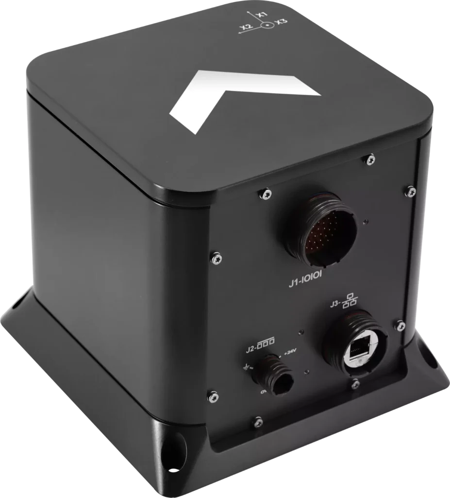
Exail has unveiled the Advans Vega SL, a new high-precision inertial navigation system that maintains navigation continuity across amphibious operations.
In contested littoral environments, maintaining reliable navigation across the sea-to-land transition remains a persistent challenge for amphibious forces. In the event of GNSS jamming, spoofing or signal unavailability, the Advans Vega SL operates independently of any external signal from vessel departure to shore, ensuring forces maintain continuous positioning and fire control readiness without reconfiguration at any stage.
The Advans Vega SL INS. (Credit: Exail)
As a single, self-contained solution covering both maritime and land phases, it also removes the integration constraints associated with multi-system architectures, which typically require reconfiguration or handover at the water-to-land transition.
With 0.05° RMS heading accuracy in the maritime phase and 0.5 mils RMS on land, the Advans Vega SL system maintains positioning continuity in GNSS-denied environments without reconfiguration.
“GNSS signal denial is now an operational assumption in any amphibious and littoral combat planning,” said Yann Le Balc’h, business development manager for land defense, Exail. “The Advans Vega SL removes satellite dependency at the most exposed phase of an amphibious operation, giving forces the autonomy to project ashore on their own terms.”
Drawing on Exail’s fiber-optic gyroscope technology, the Advans Vega SL delivers 0.05° RMS heading accuracy in the maritime phase and 0.5 mils RMS on land — the highest navigation precision achieved to date in a system designed for the full sea-to-land transition. This performance level is rooted in decades of navigation expertise across land and naval operations, now brought to bear on a capability requirement that has become increasingly critical in modern amphibious warfare.
With navigation systems in service with more than 70 navies and land forces worldwide, Exail is a recognized supplier for defense forces requiring sovereign, signal-independent positioning capability across all operational domains.
The Nippon Foundation-GEBCO Seabed 2030 Project and Kongsberg Maritime have entered a memorandum of understanding (MOU) in support of the global initiative to produce the complete map of the ocean floor. Under the terms of the MOU, the two parties will work together to advance understanding of ocean bathymetry. The effort complements the goals of the United Nations Decade of Ocean Science for Sustainable Development.
Seabed 2030 is a collaborative project between The Nippon Foundation and GEBCO to inspire the complete mapping of the world’s ocean by 2030 and to compile all bathymetric data into the freely available GEBCO Ocean Map. GEBCO is a joint project of the International Hydrographic Organization (IHO) and the Intergovernmental Oceanographic Commission (IOC) and is the only organization with a mandate to map the entire ocean floor.
Kongsberg Maritime provides solutions for safe, efficient, and sustainable maritime operations. The solutions are suitable for offshore energies, seaborne transportation, hydrography, science, navy, coastal marine, aquaculture, training services and more. Kongsberg Maritime is the largest business area within Kongsberg Gruppen ASA. The Group has an integrated portfolio of solutions for businesses, partners and nations operating from the depths of the sea to outer space and to the digital frontier.
All data collected and shared with the Seabed 2030 Project is included in the GEBCO global grid, which is free and publicly available.
The Nippon Foundation-GEBCO Seabed 2030 Project is a collaborative project between The Nippon Foundation and GEBCO. The Seabed 2030 Project, launched at the United Nations Ocean Conference in 2017 by Chairman Sasakawa of The Nippon Foundation, coordinates and oversees the sourcing and compilation of bathymetric data from different parts of the world’s ocean through its five centers into the freely-available GEBCO Grid.
Kongsberg Maritime is a global marine technology company providing technology solutions for all marine industry sectors including merchant, offshore, cruise, subsea and naval.
The 18,000-container-capacity CMA CGM Kuergelen. (Photo: CMA CGM)
Of the 273 papers researchers presented this year at the Institute of Navigation’s annual ION GNSS+ conference, which took place in Miami on Sept. 16–20, the following five focused on maritime issues. Papers are available at www.ion.org/publications/browse.cfm.
Automating the Sharing of Ocean Weather Data
The Automatic Identification System (AIS) — mandatory for large ships and used by many mid-sized ones — was designed to help avoid collisions, enable shore authorities to provide vessel traffic services, and allow coastal states to monitor their waters. It also may be used to transmit other information between AIS stations onboard and ashore.
In the aftermath of the sinking of the container ship El Faro in 2015, the U.S. National Transportation Safety Board (NTSB) and U.S. Coast Guard found a contributing factor was lack of reliable weather forecasts. The NTSB then recommended to the National Oceanic and Atmospheric Administration (NOAA) that it determine whether AIS could be used to share weather data collected by ships, to supplement the Voluntary Observing Ship (VOS) program where ships voluntarily submit weather observations to NOAA. The paper describes a successful test of this concept.
Citation. Gregory Johnson, Ken Dykstra, Gaurav Dhungana and Brian Tetreault, “Sharing Ships’ Weather Data via AIS.”
EGNOS for Maritime Navigation
The European Geostationary Navigation Overlay System (EGNOS), which has been providing guidance to civil aviation since 2011, also can support maritime, railway and road applications. This paper assesses its use for maritime navigation compliant with International Maritime Organization (IMO) requirements for harbor entrances, harbor approaches and coastal waters: 99.8% of signal availability, 99.8% of service availability, 99.97% of service continuity, and 10 meters of horizontal accuracy. A kinematic test campaign was conducted in the waters of the Canary Islands using a geodetic multi-frequency, multi-constellation receiver-antenna pair installed aboard two vessels. The EGNOS Maritime Service met all IMO requirements by achieving a signal availability of 99.999%, a service availability in 99.9% of a predefined rectangular region, and 1.06 meters of horizontal accuracy at the 95th percentile. The service continuity requirement, however, was met in only 62.50% of the predefined region. Therefore, the paper concludes that the continuity risk is the most limiting factor for expanding the EGNOS Maritime Service along the coastal waters of the Canary Islands.
Citation. Deimos Ibáñez Segura, Adria Rovira Garcia, Jaume Sanz, José Miguel Juan, Guillermo González Casado, María Teresa Alonso, José A. López Salcedo, Huamin Jia, Francisco Javier Pancorbo Garcia, Carlos Garcia Daroca, Irene Martin Calle, Santos Rodrigo Abadía Heredia and Manuel López Martínez, “A Kinematic Campaign to Evaluate EGNOS 1046 Maritime Service.”
Options for Integrity
Many maritime authorities are considering how to maintain the integrity of navigation systems as their infrastructure ages, especially given that the need for integrity in the user position is expected to increase with e-navigation services and for autonomous vessels. In harbor entrances, harbor approaches and coastal waters, the International Association of Marine Aids to Navigation and Lighthouse Authorities (IALA) prescribes an absolute horizontal accuracy of ≤10 meters 95% of the time, with an integrity risk of 99.99999%. Today’s GNSS more than meets that accuracy requirement, so the driver is integrity. Options for integrity are marine radiobeacon DGPS/DGNSS, the primary augmentation system in use today; receiver autonomous integrity monitoring (RAIM); satellite-based augmentation systems (SBAS); and others (such as commercial services or inertial.). The European MarRINav project is investigating resilient PNT options to support UK Critical National Infrastructure. Part of this work is comparing EGNOS and marine radiobeacon DGPS performance to inform international discussions and receiver standardization.
Citation. Alan Grant, George Shaw and Martin Bransby, “Considering SBAS and marine radiobeacon corrections to support safe maritime operations.”
Evaluation of WAAS for Use in Canadian Waters
Mariners navigating in Canadian waters use a ground-based augmentation system (GBAS) that provides differential corrections and integrity monitoring of GPS. This GBAS has been provided since 1994 by the Canadian Coast Guard (CCG) in the form of a differential GPS (DGPS) broadcast service. The service is only provided south of latitude 60°N in collaboration with the U.S. Coast Guard. Before embarking on a recapitalization program of its 24-year-old DGPS, and given that the U.S. Coast Guard is progressively shutting down its National Differential GPS sites, the CCG is evaluating options for its own DGPS network. Options include the wide-area augmentation system (WAAS), originally developed by the U.S. Federal Aviation Administration for civil aviation. This paper describes the authors’ evaluation for the CCG to determine the expected accuracy, integrity and availability of WAAS throughout Canadian waters, concluding that the current WAAS provides acceptable accuracy and integrity for most of Canada, excluding the higher latitudes.
Citation. Gregory Johnson, Gaurav Dhungana and Jean Delisle, “An Evaluation of WAAS 2020+ to Meet Maritime Navigation Requirements in Canadian Waters.”
GNSS + INS for Attitude Determination
Attitude determination (AD) is an important navigation component for ships and spacecraft. GNSS enables resolving their orientation in a precise and absolute manner, by employing multiple antennas rigidly mounted on the vessel. This requires carrier-phase observations, with the consequent added complexity of resolving integer ambiguities. Inertial aiding has been extensively exploited for AD, because it enables tracking fast rotation variations and bridging short periods of GNSS outage. In this paper, the fusion of inertial and GNSS information is exploited within the recursive Bayesian estimation framework, applying an Error State Kalman Filter, which, unlike common Kalman filters, tracks the error or variations in the state estimate, posing meaningful advantages for AD. The results show that the inertial aiding, along with a constrained attitude model for the float estimation, significantly improve the performance of attitude determination compared to classical unaided baseline tracking.
Citation. Daniel Medina, Vincenzo Centrone, Ralf Ziebold, and Jesús García, “Attitude Determination via GNSS Carrier Phase and Inertial Aiding.”
Airbus Defence and Space has launched The OneAtlas Platform, a collaborative environment to access premium imagery, perform large-scale image processing, extract insights and benefit from Airbus assets for solution development.
OneAtlas is offering a 30-day free trial, giving customers streaming access to imagery, sample change detection reports, and global imagery and data layers, including the basemap and the WorldDEM.
Besides access to a comprehensive archive with premium imagery, users can try services such as:
Ocean Finder for the maritime industry
Verde for precision agriculture
Starling for forest management
Earth Monitor for tracking changes over an area of interest
The developer portal provides more information through API documentation and discusses how to benefit from the imagery either in streaming or download format.
The Ocean Finder provides a satellite-based maritime ship detection service. (Photo: OneAtlas)
The Bathymetrics Data Portal allows users to search, purchase and automatically download water-depth information directly from an online store to their computer.
The Bathymetrics Data Portal is a combined offering by DHI, experts in water environments; TCarta, a global provider of marine geospatial products; and powered by DigitalGlobe, provider of high-resolution satellite imagery.
The dedicated commercial bathymetry portal offers continuously expanding 2m Bathymetry data in shallow water areas and a global database of interpolated 90m bathymetry. The portal allows users to search for data in their area of interest and purchase what they need. Data is priced by the square kilometer; the customer pays online with credit card and can download the data shortly after.
“We are very excited about this launch, as we have made direct access to off-the-shelf bathymetry data very easy and intuitive,” said DHI COO, Jacob Høst-Madsen. “The shop marks an important milestone in our continued quest to develop and offer high quality, affordable bathymetry data”
Bathymetric products are used extensively by organizations involved in energy infrastructure development, port construction, environmental monitoring, aquaculture planning and hydrodynamic modeling.
“The per-kilometer pricing model puts high-quality bathymetric data within easy reach of organizations of any size in all industries,” said TCarta CEO David Critchley. “One-person engineering shops, academic entities and other organizations with limited budgets can now engage in complex offshore projects.”
The portal is constantly being updated with new and improved data, providing users with the best available bathymetric information around the world.
Coastal Zone Mapping and Imaging Lidar System (CZMIL) to be shared at conferences as a critical rapid environmental assessment tool for both natural and manmade disasters
Teledyne Optech’s Coastal Zone Mapping and Imaging Lidar (CZMIL) system is a critical rapid environmental assessment tool for monitoring natural and man-made disasters. From detecting sewage pipe leaks, mapping oil slicks and measuring coastline changes after hurricanes, to counting underwater debris in the Great Pacific Garbage Patch, CZMIL excels at identifying and monitoring oceanic environmental changes, especially in emergency scenarios.
At the Oceans ’17 MTS/IEEE conference in Aberdeen, Scotland, Senior Scientist Viktor Feygels will present “CZMIL as a Rapid Environmental Disaster Response Tool.” Using case studies from CZMIL and its predecessor systems, Feygels will describe four distinct applications of Teledyne Optech lidar bathymeters. Attendees can catch this presentation in Room 15 on June 21 at 12:10 p.m.
Research Scientist Hieu Duong and Marine Business Manager Bob Marthouse will present “Small-Object Detection using Coastal Zone Mapping and Imaging Lidar (CZMIL)” at the Teledyne CARIS International User Group Conference in Ottawa, Canada. Conference attendees can hear about these applications on Thursday, June 22, 10:05 am, in the Rideau Room.
“CZMIL has proved to be ideally suited for rapid environmental assessment and small-object detection,” said Bob Marthouse. “Both the upcoming MTS/IEEE Oceans ‘17 conference and the recent United Nations Ocean Conference during the week of June 5 underline the urgent requirement to more critically monitor our oceans and coastlines. At Teledyne Optech, we were pleased to be part of this ongoing effort.”
The app provides a new way to measure marine environments on a 3D interactive map for more cost-effective fishery planning and informed conservation.
Esri has released an Ecological Marine Units (EMU) app for mobile devices. The app is a resource for scientists, educators, governments and industries seeking accessible information and imagery about the ocean’s long-term physical and nutrient properties.
The EMU app puts data such as temperature, salinity and dissolved oxygen from 52 million locations throughout the world’s oceans at any user’s fingertips. This data informs how livable marine environments are for ocean-dwelling species as well as the overall health of the ecosystem.
Organizations involved in fishery planning, for instance, can use the EMU mobile app to review proposed boundaries with a better understanding of which habitats will likely harbor certain species and manage fisheries more cost-effectively.
By using the EMU mobile app, industries that depend on fishing yields can spend less time and money on areas that are less profitable. Conservation groups that need easy access to information on the environments of marine protected areas (MPA) to more effectively regulate them now also have a mobile tool for understanding the chemical makeup of these areas.
“The EMU mobile app will serve as a fresh, widely available resource for professionals who benefit from a deeper understanding of the ocean’s structure — its salinity, temperature, oxygen levels and nutrients,” said Dawn Wright, Esri chief scientist. “Scientists and nonscientists alike who must study and understand the ocean now have the freedom of a convenient mobile interface with this vast wealth of environmental data.”
The primary data source for the EMU mobile app is the National Oceanic and Atmospheric Administration’s (NOAA) authoritative World Ocean Atlas, with marine chemistry information from the National Aeronautics and Space Administration (NASA) and topographic data from GRID-Arendal.
The app provides access to this globally comprehensive, data-driven 2D and 3D data and serves as an educational tool for easily understanding marine environments and how they are affected by climate change.
The EMU mobile app is free from the App Store and Google Play.
TCarta Marine LLC of Denver, Colorado, has merged with Proteus Geo of Oxford, England, to create a global mapping company that provides bathymetric and marine data sets from the shallow coastal zone out to the continental shelf.
The new company is called TCarta Marine and will maintain offices in Denver and Oxford.
“By merging, we believe the merged company provides a wider and more sophisticated range of products than any other supplier worldwide,” said TCarta Marine CEO David Critchley. “TCarta Marine is now a one-stop shop for bathymetric and marine data.”
Image: Proteus Geo
TCarta Marine will continue offering all existing product lines from the two companies, as well as new products and services under development. Primary markets served will be engineering, oil and gas, government and defense with expansion planned into the insurance, 3D modeling and aquaculture industries.
“Our goal is to make it easier for the marine community to obtain and use quality mapping data,” said TCarta Marine President Kyle Goodrich. “To support every phase of offshore projects, we now offer lower resolution bathymetry for regional planning as well as high-resolution, highly accurate seafloor modeling for precise coastal engineering activities. Additionally, we offer a range of global and regional marine basemaps.”
In recent years, TCarta Marine and Proteus Geo collaborated on many projects and had numerous clients in common due to the complementary nature of their product lines.
David Critchley established Proteus Geo in the United Kingdom in 2011 to leverage a new technology that derives high-accuracy seafloor survey and seabed classification information from multispectral satellite imagery. Operating at a fraction of the cost of traditional ship and airborne bathymetric technologies, the Proteus methodology has been deployed extensively in energy exploration, infrastructure engineering and environmental applications in shallow-water coastal zones.
“The two-meter satellite-derived bathymetric data can be derived to depths of 35 meters depending on water clarity and every depth has an uncertainty value assigned,” said Critchley.
TCarta Marine was started in 2008 by Kyle Goodrich to fill an enormous gap in quality bathymetric data from the littoral zone out to the base of the continental shelf, distance often spanning hundreds of kilometers. The firm developed proprietary techniques for aggregating seafloor depth data from numerous medium- to coarse-resolution sources, including navigation charts, ship tracklines, and boat surveys. TCarta Marine has built an off-the-shelf line of 90- and 30-meter GIS-ready products covering the Earth’s most important marine areas.
“Our bathymetric products are available via annual subscription for streaming directly into our clients’ GIS and mapping applications,” said Goodrich. “Oil, gas and renewable energy companies have become major users of TCarta Marine products.”
As president of the new TCarta Marine, Goodrich will focus on developing additional products and innovative methods for delivering them. The global company seeks to expand its foothold in traditional marine markets and cultivate new applications for seafloor data. Critchley, as CEO of TCarta Marine, will be responsible for business development in new geographic regions of the world.
In the near term, TCarta Marine and Proteus Geo customers can look forward to purchasing the existing 90-, 30- and 2-meter resolution product lines online through a new web portal, now under development. Information can be found and orders placed now through the new unified TCarta Marine website at www.TCartaMarine.com.
Proteus FZC, an affiliated company of Proteus Geo based in the United Arab Emirates, will remain a stand-alone company offering terrestrial geospatial and marine consulting services in the Middle East.
Fugro has commissioned an additional airborne laser bathymetry system to underpin its position in the development and application of bathymetric LiDAR technology. The combined Fugro LADS Mk 3 and Riegl VQ-820-G systems provide seamless measurements and mapping of nearshore and shallow water environments. The increased capability will enable Fugro to deliver simultaneous topographic and bathymetric surveys in multiple geographical areas.
With high power and frequency, the combined systems achieve superior coverage that minimizes gaps and outperforms lower energy alternatives and single-sensor systems in all conditions, particularly in difficult environments, Fugro said. They are highly adaptable and small enough to be installed in a variety of light aircraft.
With continued operations across the Middle East during 2015, Fugro will also begin a South West Pacific ALB survey campaign following the award of projects in multiple locations to support nautical charting, coastal engineering, scientific assessments, coastal management, benthic habitat mapping and climate change initiatives.
Since 2012, Fugro has operated simultaneous topographic and bathymetric LiDAR systems in France, Japan, New Zealand and the Middle East. Successful results from Japanese coastal areas include returns from the Fugro LADS Mk3 sensor to 50 meters while recent surveys in Saudi Arabia had even more impressive results, with 65-meter depth returns. The deep water returns combined with high-density shallow water and near coastal returns result in a seamless dataset from ridge to deep reef.
A bill to establish a “Digital Coast” program whereby the National Oceanic and Atmospheric Administration (NOAA) develops a coordinated and comprehensive national mapping effort for coastal, state and territorial waters of the United States, has been introduced in the U.S. Senate, earning praise from MAPPS (the national association of private sector geospatial firms).
More than half of all Americans, 153 million people, live on or near a coast, and an additional 12 million are expected to move to the coasts over the next decade. Yet, despite this population density and economic development, much of the 95,000 miles of U.S. shoreline does not have current, accurate maps and geospatial information; moreover, much of what does exist pre-dates the 1970s.
“The Digital Coast Act is needed to realize the concept of a Digital Coast as recommended by the National Academy of Sciences (NAS),” said MAPPS Executive Director John Palatiello. “The Digital Coast Act provides an opportunity to help America’s ocean, coastal and shoreline areas by addressing issues raised by the U.S. Oceans Commission, the Pew Commission, as well as several NAS reports, all of which have highlighted the need for surveying, charting, remote sensing, and geospatial data of America’s coasts, harbors, ports, shorelines and ocean resources critical to the nation’s most basic economic and recreational activities, to smartly conserve a fragile environment.”
“Greater emphasis has been paid to monitoring sea-level rise, coastal conservation and emergency preparedness and response in the wake of natural and manmade disasters,” MAPPS President Jeff Lower, said. “This Digital Coast Act will coordinate the pooling of resources from multiple agencies (federal, state, and local) and other stakeholders to map the various needs once, and then utilize and apply the high-quality data and products numerous times, thus reducing taxpayer waste while maximizing the return on investment for all stakeholders.” The Digital Coast is a geospatially enabled program to improve coordination and support work with stakeholders to identify geospatial priorities; improve coordination of coastal mapping and management activities; use standards and standardized methods for data acquisition, processing, and distribution to ensure broadest utility of data; promote best practices when applying geospatial data for coastal decision making; and contract for the collection and creation of quality non-navigation feature data sets to include: shoreline change, satellite and aerial imagery, land use and land cover maps, benthic habitat mapping, terrestrial topography, shallow water bathymetry, and submerged aquatic vegetation.
U.S. Senator Tammy Baldwin of Wisconsin introduced the Digital Coast Act of 2014 on September 18. The bill compliments a bipartisan effort in the U.S. House of Representatives by C.A. “Dutch” Ruppersberger (D-MD) and Don Young (R-AK), cosponsors of Digital Coast Act, H.R 1382.