Tag: Optical Zonu

  • Optical Zonu offers ‘GPS at the Edge’ for 4G/5G small cell deployments

    Optical Zonu offers ‘GPS at the Edge’ for 4G/5G small cell deployments

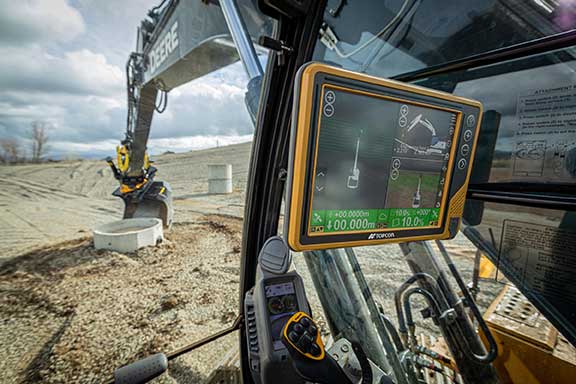
    The huge current investment in deploying 5G mobile networks is promoted by setting high expectations for significantly increased throughput and reduced latency.

    This can only be realized by deploying the network radios close to the users, especially for the millimeter-wave frequencies with their short propagation distance.

    This also means a high density of radios, often imbedded within macro coverage.

    To coordinate seamless functioning, network synchronization accuracy must be much higher than with legacy deployments, according to Optical Zonu. The greatly enhanced data throughput with advanced features such as aggregation, massive multiple-input/multiple-output (MIMO) and beam steering require highly accurate network timing and phase coordination.

    Small cells close to a network’s edge are usually far from the hub where the grandmaster timing server generates the PTP timing signal and sends it to the network edge over the Ethernet backhaul. The long runs require multiple hops through routers and switches. Each of these adds dynamically changing packet delays depending on network loading. Also, there are inevitable asymmetries between the upstream and downstream packet delays. These timing errors can result in a drastically reduced network performance.

    One way to correct these timing errors is to connect an edge grandmaster server at the small cell location connected to the local backhaul router. Connecting the GPS directly to each of the small cells is the other way.

    The GPS approach is simple in concept, but has been problematic since, with small cells distributed in the facility, many or all the units can be far from a window where a GPS antenna could be mounted.

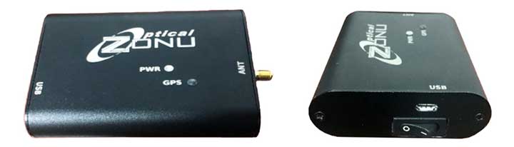
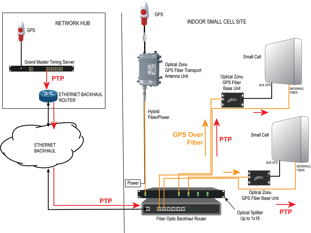
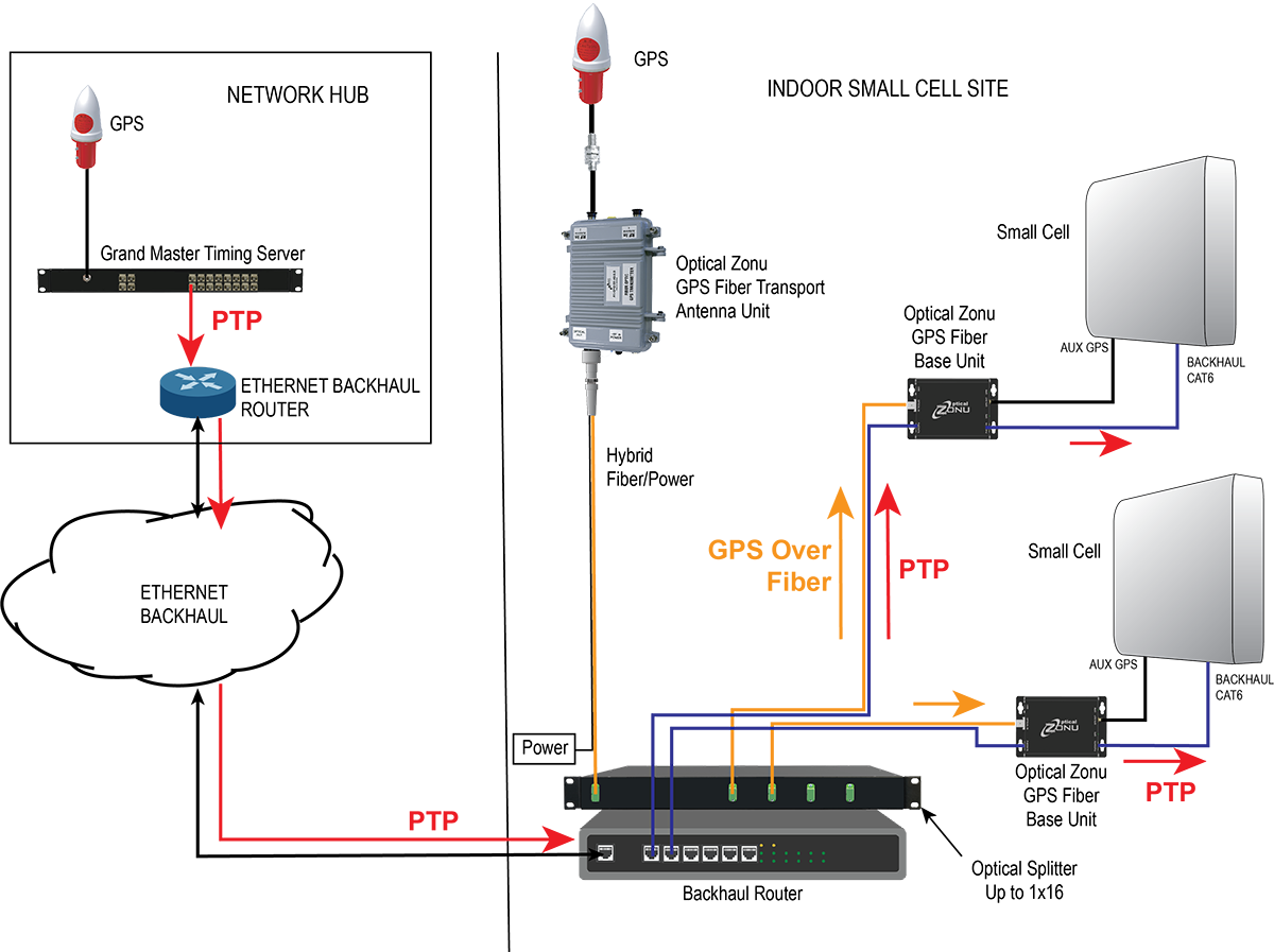
    Optical Zonu, a U.S. carrier-approved supplier of RF-over-fiber transport solutions, has solved this problem with its GPS at the Edge kit. The GPS-over-fiber solution distributes GPS to each small-cell location alongside the backhaul.

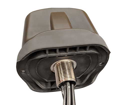
    A compact GPS fiber antenna unit connects to a GPS antenna on the roof. A single cable connection to this unit provides power to the unit and brings the fiber-optic connection to an optical splitter, which is collocated with the local router for the small-cell backhaul.

    The fibers from this splitter are routed along with the backhaul cable to each small-cell location, where they each connect to a small fiber base unit that recovers the GPS signal and connects it to the auxiliary GPS port on each small cell.

    Optical Zonu offers two variants.

    Small cells with fiber-optic backhaul. Higher power cells typically use a fiber-optic backhaul and require local AC power. In this case, one of the fibers in the cable to each small cell is used for the GPS connection, and each base unit connects to the local AC power with an adapter. In this case, the only additional cable needed is the single run to the rooftop.

    Diagram: Optical Zonu
    Diagram: Optical Zonu

    Small cells with a CATx backhaul. This setup is typical for lower power small cells. In this architecture, a single fiber is pulled along with the CAT6 backhaul cable. A single hybrid fiber/CAT6 cable can also be used. The fiber is connected to a small fiber base unit at each small cell to recover the GPS signal, which is connected to the small cell auxiliary GPS port. The CAT6 is also connected to the fiber base unit. The backhaul is passed through from the small cell, and the PoE++ is tapped to power the base unit. Once again, the only additional cable pull is the single run to the rooftop antenna — local power isn’t needed at every small cell location.

    Diagram: Optical Zonu
    Diagram: Optical Zonu

    The Optical Zonu GPS at the Edge kit provides an easy-to-install and cost-effective solution that guarantees the highest timing and phase accuracy for a network that is vendor agnostic and, as with the edge grandmaster approach, still has the central PTP as a backup.

    For more information, visit Optical Zonu.

  • Launchpad: GNSS antennas, gyroscopes, lidars

    Launchpad: GNSS antennas, gyroscopes, lidars

    A roundup of recent products in the GNSS and inertial positioning industry from the June 2020 issue of GPS World magazine.


    OEM

    GPS Tester

    Compact antenna testing for mobile deployments

    Photo: Zonu
    Photo: Zonu

    The ZonuSkyShot is designed for quick testing during the critical installation phase of an antenna at a new site build or small-cell integration. The compact tester is designed for integrating a Zeno GPS solution, but works as a neutral testing device. SkyShot is a compact GPS receiver that detects the presence of a GPS signal, indicated on the top-panel LED. The receiver can be accessed via the USB port on the base unit, allowing the user to see the available satellites by using the app provided with the system and available at the Optical Zonu website. The receiver can simultaneously track up to 16 satellites while searching for new ones. Because of this, a problem can be found and mitigated when a GPS antenna is installed, rather than when hardware is being integrated further down the line. Close-out of projects can be indicated with screenshots of satellite visibility via the micro-USB port to a laptop.

    Optical Zonu, opticalzonu.com

    Police antenna

    Seamless installation on leading 2020 police sport utility vehicles

    Photo: PCTEL
    Photo: PCTEL

    The Trooper TRP-20INT antenna platform supports the high-speed requirements of complex RF communication systems used for critical communications in FirstNet public safety and intelligent transportation systems. The antennas feature two 5G elements compatible with cellular routers supporting 600-MHz to 6-GHz frequencies. PCTEL’s proprietary high-rejection multi-GNSS technology is included for high-precision tracking and asset management.

    PCTEL, pctel.com

    Anti-jam unit

    Mitigates RF interference

    Photo: Quantum Reversal
    Photo: Quantum Reversal

    The QR-100 L1/L2 GPS anti-jamming unit mitigates RF interference or jamming signals using a spatial domain of an antenna array reception pattern. Three passive antennas of the customer’s choice can be connected to the QR-100 unit using built-in SMA connectors. The unit default configuration (no jamming signal present) has a 120-degree phase gradient between antenna elements to maximize the reception of GPS right-hand circularly polarized (RHCP) signals. This feature allows the unit to be connected to either RHCP-type antennas or linearly polarized antennas. The default configuration of the unit is designed to connect to passive GPS antennas.

    Quantum Reversal, quantumreversal.com

    Gyroscopes

    Two and three Axis for use in harsh environments.

    Photo: Inertial Labs
    Photo: Inertial Labs

    Inertial Labs’ TAG-200 two-axis and TAG-300 three-axis gyroscopes are developed for electro-optical systems, gimbals, line-of-sight, and pan-and-tilt platforms for stabilization and pointing applications. TAG-200 and TAG-300 use advanced-performance, tactical-grade MEMS sensitive elements to accomplish complex tasks requiring accurate stabilization of assorted platforms. The gyroscopes, designed for use in harsh environments, can withstand extreme shock and vibration in accordance with MIL-STD-810 ground mobile use. They are fully digitized, include built-in test functions and have no moving parts. The gyroscopes include low noise, low latency, wide bandwidth, high data rate, low bias drift, low VRE, high MTBF and are ITAR-free. They are factory calibrated over the operational temperature range and are quality assurance and quality compliance tested and supplied with individual calibration and acceptance test certificates.

    Inertial Labs, inertiallabs.com


    SURVEYING & MAPPING

    Grade Control

    Version 2 of software adds features

    Photo: Trimble
    Photo: Trimble

    Earthworks Grade Control Platform version 2.0 features improvements to enable faster return on investment, increase productivity and decrease training time for operators. Horizontal Steering Control for dozers automatically controls the machine to follow any horizontal alignment such as a back of a curb, breakline, roadway centerline or bottom of slope, without operator assistance. Augmented reality for excavators enables users to understand 3D models, cut/fill information, slope data and other bench points and reference points on the in-cab display in context, without the need to interpret complex 2D plans or stakes. A new mastless motor grader configuration gives operators an improved range of blade motion, allowing for machine control in applications where it previously was not possible. Integrated Trimble Loadrite Payload Management displays grade control and accurate payload data on one screen, increasing mass haul productivity and efficiency by preventing underloading, and improving safety by avoiding overloading. Trimble Earthworks is also now available for compact grading attachments with dual GNSS, single GNSS and total station guidance options. The Earthworks Assistant App provides access to Earthworks learning material and documentation, allowing for a shorter learning curve and less downtime for operators.

    Trimble, trimble.com

    Tilt function

    New feature for automatic excavator

    Photo: Topcon
    Photo: Topcon

    The addition of advanced tilt and rotation functionality allows Automatic Excavator operators to easily swivel or tilt the bucket with automatic boom control for faster and more efficient excavation. If excavator operators are in situations such as at the top of the slope, grading a long incline and not totally perpendicularly lined up, the added feature makes it easier to position the cutting edge of the bucket to the surface. Operators can excavate more quickly, moving the excavator fewer times with less wear and tear on the chassis. It is also beneficial when navigating around manholes, trenches and tight spaces.

    Topcon, topcon.com


    TRANSPORTATION

    Lidar sensors

    For L3/L4 autonomous driving

    Photo: Livox
    Photo: Livox

    The Horizon is a high-performance lidar sensor built for Level 3 and Level 4 autonomous driving. It has a long-distance detection range of up to 260 meters, high-density point clouds, and is so small it can be embedded easily into vehicles. The Tele-15 has achieved a reliable detection range of up to 500 meters, offering improved safety for high-speed autonomous vehicles. Both the Horizon and Tele-15 high-performance lidar sensors feature a new scanning method that offers improved sensing performance at a low cost.

    Livox Technology, www.livoxtech.com

    INS module

    1.3°/hr automotive IMU sensor

    Photo: Aceinna
    Photo: Aceinna

    The IMU383ZA is a high-accuracy, triple-redundant inertial measurement unit (IMU) for guidance and navigation solutions in autonomous machines and vehicles. It integrates triple-redundant, 3-axis micro-electromechanical system (MEMS) accelerometer and gyroscope sensors. The IMU383ZA is pin-compatible with the IMU381ZA and offers high performance of 1.3 deg/hr, 0.08 deg/root-hr. The miniature module is factory-calibrated over the –40° C to +85° C industrial temperature range to provide consistent performance through extreme operating environments for a wide variety of applications.

    Aceinna, aceinna.com

  • Optical Zonu announces GPS tester for antenna installation

    Optical Zonu announces GPS tester for antenna installation

    Optical Zonu has introduced the ZonuSkyShot GPS tester, designed for quick testing during the critical installation phase of an antenna at a new site build or small cell integration.

    The compact tester is designed for integrating one of Optical Zonu’s GPS solutions, but is equally capable of working as a neutral testing device.

    Fig. 1. Screenshot of ZonuSkyshot software output. (Screenshot: Optical Zonu)
    Fig. 1. Screenshot of ZonuSkyshot software output. (Screenshot: Optical Zonu)

    The ZonuSkyShot is a compact GPS receiver that detects the presence of a GPS signal, indicated on the top-panel LED. The receiver can be accessed at the USB port on the base unit, allowing the user to see the available satellites by using the app provided with the system and available at the Optical Zonu website.

    The receiver can simultaneously track up to 16 satellites while searching for new ones. Because of this, a problem can be found and mitigated when a GPS antenna is installed, rather than when hardware is being integrating further down the line. Close-out of projects can be indicated with with screenshots of satellite visibility via the micro-USB port to a laptop.

    The app provides:

    • RF GPS signal presence
    • GPS antenna functionality
    • Optical transmitter functionality
    • Fiber connectivity
    • Optical receiver functionality

    Pre-orders are now being accepted for the kit, which includes the handheld device with power supply, carrying case, jumpers and SMA cable.