Tag: post processed kinematic

  • Emlid Studio released for GNSS post-processing

    Emlid Studio released for GNSS post-processing

    Image: Emlid
    Image: Emlid

    Emlid has released Emlid Studio, a new post-processed  kinematic (PPK) application designed specifically for post-processing GNSS data. The app is free and available for Windows and Mac users.

    Emlid Studio features a simple interface to make post-processing easy. The app allows users to convert raw GNSS logs into RINEX, post-process static and kinematic data, geotag images from drones (including DJI brand), and extract points from survey projects completed with Emlid’s ReachView 3 app.

    With Emlid Studio, users can post-process data recorded with Emlid Reach receivers and other GNSS receivers or NTRIP services. Post-processing requires RINEX observation and navigation files. Raw data in UBX and RTCM3 format also can be used — Emlid Studio will automatically convert them into RINEX.

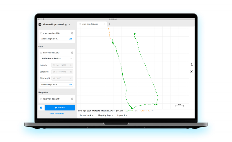
    The post-processing workflow is straightforward. Users can receive precise positioning of a single point or track depending on the positioning mode. Users can simply add several RINEX files and enter the antenna height, click the Process button, and Emlid Studio will do the rest. Once the resulting position file is ready, the plot will show the result.

    Another tool is available for the users of Reach receivers and the ReachView 3 app. The Stop & Go feature allows users to improve the coordinates of points collected in single or float modes.

    Geotagging for drone mapping. Adding geotags to images’ EXIF data requires aerial photos and the POS file with the events. Emlid Studio also provides a chance to update data from the RTK drone in case of a float or single solution during a survey. A set of RINEX logs from a base and drone, an MRK file and images from the drone are dragged and dropped into specific file slots, providing result in seconds.

  • Emlid offers two PPK modules for cm-accurate drone mapping

    Emlid offers two PPK modules for cm-accurate drone mapping

    Reach M+ and M2. (Photo: Emlid)
    Reach M+ and M2. (Photo: Emlid)

    Emlid is offering two positioning modules for mapping with unmanned aerial vehicles (UAVs). Both the Reach M+ and Reach M2 provide centimeter-level accuracy in real-time kinematic (RTK) and post-processed kinematic (PPK) modes, enabling precise UAV mapping with fewer ground control points.

    The Reach M+ single-band receiver has a baseline up to 20 kilometers in PPK. The Reach M2 is a multi-band receiver with a baseline up to 100 kilometers in PPK.

    Usually autopilot triggers the camera and records the coordinate it has at that moment. When the drone is flying at 20 m/s and GPS works at 5 Hz, the UAV autopilot will have position readings only every four minutes, which is not suitable for precise georeferencing. In addition, there is always a delay between the trigger and the actual moment the photo is taken.

    Reach solves this problem by connecting directly to the camera’s hot-shoe port, which is synced with the shutter. The time and coordinates of each photo are logged with a resolution of less than a microsecond. Reach captures flash sync pulses with sub-microsecond resolution and stores them in a raw data RINEX log in the internal memory. This method allows ground control points to be used only to check accuracy.

    The Reach RS2. (Photo: Emlid)
    The Reach RS2. (Photo: Emlid)

    The Reach M2 PPK UAV mapping kit consist of the Reach M2 multi-band GNSS receiver onboard the aircraft that records the location of each photo at a frequency of 20 Hz. It is combined with the Reach RS2 GNSS multi-band receiver on the ground, drastically reducing the number of ground control points and simplifying the setup process on site, while maximizing the accuracy to centimeter levels even in remote areas.

    The M2 tracks GPS/QZSS (L1, L2), GLONASS (L1, L2), BeiDou (B1, B2), Galileo (E1, E5) and SBAS (L1C/A), and receives a fixed solution almost instantly.

  • Klau Geomatics debuts hybrid PPK PPP processing solution

    Klau Geomatics debuts hybrid PPK PPP processing solution

    Logo: Klau Geomatics

    Klau Geomatics has released processing that brings precise point positioning (PPP) and post processed kinematic (PPK) together in an optimized solution.

    The autonomous solution can work anywhere without any other user inputs, such as base station data and radio/GSM links, the company added.

    According to Klau Geomatics, the solution works on its own to achieve high accuracy, regardless of the location of the user. Accurate datum and tectonic plate motion corrections, specific to different countries and regions, are automatically applied to deliver the most accurate solutions.

    In addition, Klau Geomatics’ NRT technology gives users — specifically those in the drone inspection industry — the ability to attain absolute accuracy to analyze change over time on 3D assets, the company said. The precise corrections are applied to data from custom-tuned KlauPPK GNSS receivers in the KlauPPK post processing software to enable centimeter-level accuracy anywhere in the world without the need for RTK, CORS or local base station data.

    Finally, Klau Geomatics’ hybrid terrestrial multi station and PPP algorithm are offering even more refined accuracy in areas such as the U.S., Europe, Japan, New Zealand and Australia. Data from as many as 15 reliable long-range CORS stations, where available, are applied to the processing. The enhanced PPP solution achieves 1-3cm XYZ absolute accuracy in many parts of the world.

    The same KlauPPK software workflow applies, to synchronise camera events, apply lever arm corrections, manage coordinate systems and geoids, apply site localizations, capture ground points and more. Instead of choosing a base station, which should be within 20 miles of the site, or setting up an RTK radio link, users with an active KlauPPK subscription can process a high accuracy trajectory, anywhere, without any other inputs, Klau Geomatics said.