Tag: PPP-RTK

  • Hybrid RTK: A scalable path to high‑precision positioning for the IoT era

    Hybrid RTK: A scalable path to high‑precision positioning for the IoT era

    The world is rapidly filling with connected devices. IoT Analytics reports that 18.5 billion IoT devices were online in 2024, with growth accelerating toward an expected 21.1 billion by the end of 2025 and 39 billion by 2030. As artificial intelligence drives demand for richer, more precise device data, the need for reliable, high‑accuracy positioning becomes foundational.

    Yet today’s GNSS infrastructure — including cellular-based real‑time kinematic (RTK) networks — was never designed for this scale. Billions of devices — from vehicles to drones to industrial sensors — depend on location data, but the traditional GPS model struggles under three converging pressures: (1) massive device growth, (2) rising accuracy requirements, and (3) increasing vulnerability to interference.

    These pressures are reshaping expectations for positioning, navigation and timing (PNT) and creating demand for a new, more resilient delivery model.

    Why Accuracy and Resilience Matter More Than Ever

    Autonomous systems are the clearest example of the accuracy challenge. Xona Space Systems CTO Dr. Tyler Reid notes that safe autonomous driving requires 10 cm accuracy 95% of the time and 30 cm accuracy at “eleven nines” reliability. Standard GPS, accurate only to several meters, cannot meet these thresholds — even with traditional enhancement techniques.

    At the same time, GNSS signals face growing threats. Spoofing and jamming events are now daily occurrences in parts of Europe, and U.S. federal agencies increasingly require contract bidders to incorporate resilient PNT technologies alongside legacy GNSS.

    Finally, the explosion of IoT devices introduces a network‑scale challenge. Many of these devices could benefit from high‑precision positioning, but continuous unicast RTK streams are not an efficient use of cellular networks, especially as billions of devices come online.

    Together, these factors point to a simple conclusion:

    A new delivery model for high‑precision GNSS corrections is needed — one that is accurate, resilient, and scalable.

    Why a Hybrid Approach Is Required

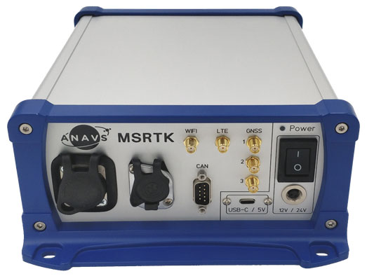
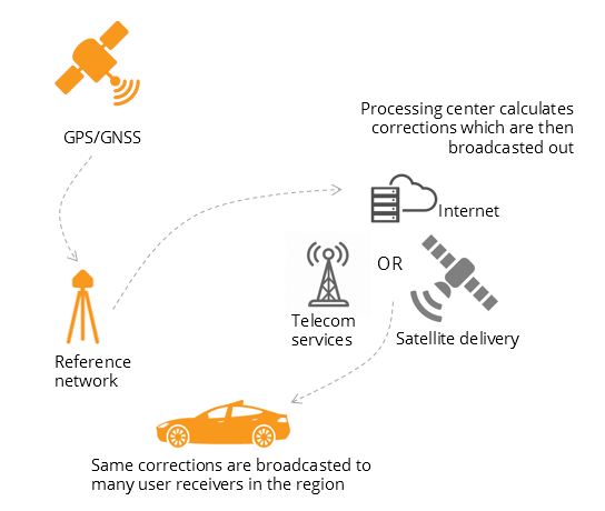
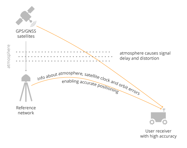
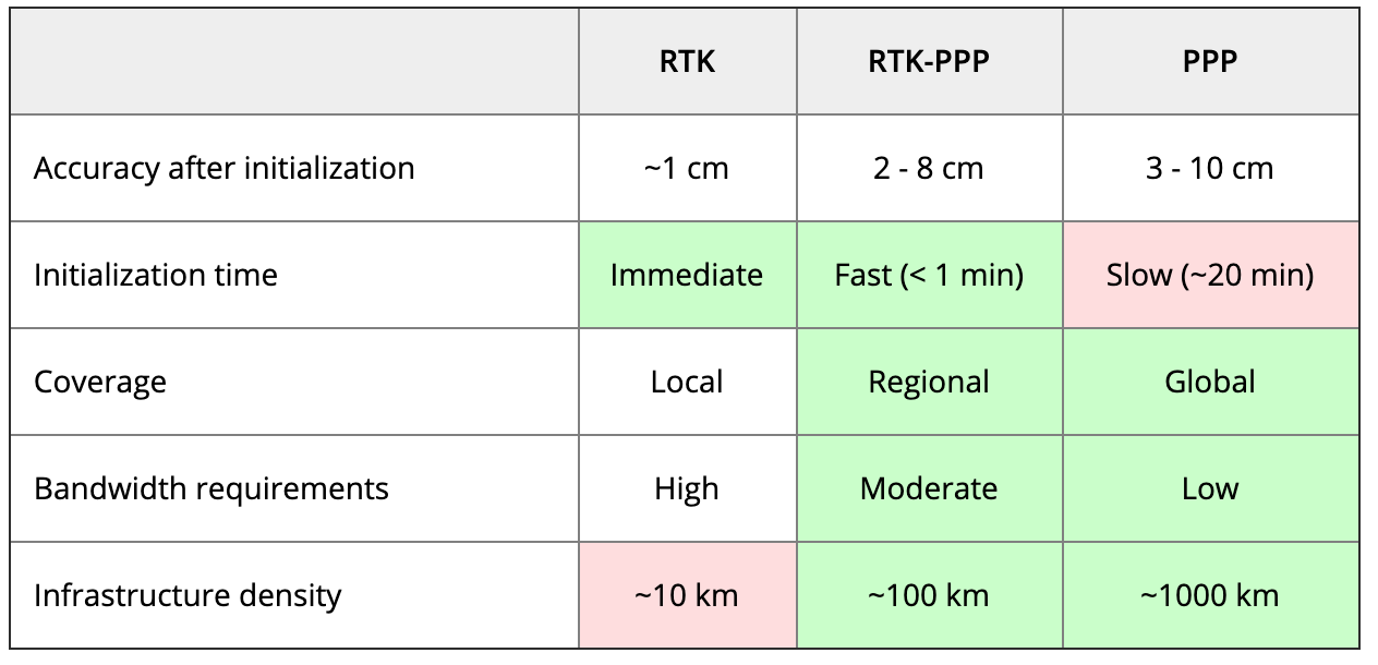
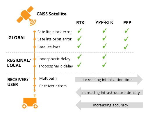
    RTK positioning is the gold standard for centimeter‑level accuracy. It works by combining GNSS signals with correction data from a known base station. However, traditional RTK has two major limitations:

    1. Coverage constraints — corrections must be delivered within a limited range of the base station due to the fact that accuracy diminishes the further the GNSS base is from the rover.
    2. Network constraints — corrections are typically delivered over cellular networks, which become inefficient at scale.

    Precise Point Positioning (PPP‑RTK) can extend range and reduce dependency on local base stations, but today’s PPP‑RTK implementations are proprietary and lack a common standard.

    To support billions of devices — many mobile, many mission‑critical — the industry needs a correction‑delivery model that is:

    • Nationwide
    • Efficient at scale
    • Resilient to interference
    • Cost‑effective for high‑volume IoT deployments

    This is where hybrid RTK becomes essential.

    Introducing Hybrid RTK: A Dual‑Path Delivery Model

    Hybrid RTK refers to the dual‑path delivery of GNSS correction data, consisting of:

    • Primary path: ATSC 3.0 broadcast
    • Fallback path: Cellular (LTE/5G)
    • Upstream messaging: Cellular for acknowledgments or device telemetry

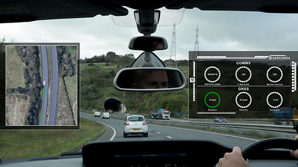
    Compared to a satellite-based RTK solution or even a cellular-only RTK solution, hybrid RTK will deliver corrections over a far more reliable and scalable network, because it’s both broadcast and terrestrial-based.

    Why broadcast first?

    ATSC 3.0 provides:

    • One‑to‑many multicast efficiency
    • Predictable capacity and uniform latency
    • Wide coverage footprints
    • Strong penetration in dense urban environments
    • Lower cost per delivered bit

    This makes it ideal for distributing high‑precision correction data to large numbers of devices simultaneously — something cellular networks are not optimized for.

    Why cellular second?

    Cellular fills in:

    • Coverage gaps where ATSC 3.0 is not yet deployed
    • Uplink needs (e.g., device status, position feedback)
    • Mobility scenarios requiring two‑way communication

    The result is a resilient, nationwide correction layer that scales with IoT growth.

    EdgeBeam Wireless: A New Entrant with a Broadcast‑First Architecture

    EdgeBeam Wireless is deploying a hybrid RTK network that leverages the existing infrastructure of U.S. television broadcasters — including secure facilities, hardened towers, and nationwide engineering resources — for both over-the-air RTK delivery and collocating GNSS base stations.

    This approach provides several advantages:

    • Accelerated deployment of GNSS base stations designed to complement existing base networks.
    • Lower infrastructure costs than cellular‑only RTK networks.
    • High reliability through broadcast delivery.
    • Scalable distribution for dense IoT environments.
    • Nationwide reach as ATSC 3.0 coverage expands.

    EdgeBeam’s broadcast‑first model — branded by the company as  “Enhanced GPS” or  “eGPS” — is best understood simply as hybrid RTK with broadcast as the primary downlink. While this hybrid approach does require some additional hardware to receive the broadcast, pricing is already very competitive to cellular because these chips will be found in every television set in the country. Moreover, EdgeBeam already has products available for end users that want to leverage a hybrid network without having to do any development work.

    Broadcast RTK: A New Network Layer at the Edge

    Broadcast RTK uses ATSC 3.0 to distribute GNSS correction data over the last mile. This creates a new edge network layer that can support both GNSS and other data applications, including:

    • High‑precision GNSS corrections
    • Multicast distribution of positioning data
    • Offloading of appropriate high‑volume traffic (e.g., video) from cellular networks
    • Enterprise‑grade reliability for industrial and transportation systems

    By shifting the heavy downlink load to broadcast, cellular networks are freed to handle uplink messaging and mobility support — a more efficient division of labor.

    This hybrid architecture is not just about improving individual device accuracy. It enables something more powerful.

    A New Generation of Shared Situational Truth

    When many devices operate on the same centimeter‑accurate reference frame at the same time, a new capability emerges: Shared Situational Truth (also known as shared situational awareness).

    This refers to a consistent, real‑time understanding of location and timing across a fleet, system, or environment. Hybrid RTK enables this by delivering synchronized, high‑precision PNT to large numbers of devices simultaneously. By offloading RTK delivery to a broadcast network, cellular and other communication networks can then be used to share a device’s position and other data with other local devices.

    What is being shared?

    • Precise location
    • Precise timing

    Who is sharing it?

    • Vehicles
    • Fleets
    • Drones
    • Industrial robots
    • Infrastructure sensors
    • Emergency services
    • Insurance and logistics platforms

    What does it enable?

    Examples include:

    • Safer ADAS/ADS through lane‑level awareness
    • Collision avoidance for drones and autonomous systems
    • Fleet optimization using precise, time‑aligned movement history
    • Improved insurance models through reliable behavior measurement
    • Faster accident resolution with time-synchronized location records
    • Infrastructure‑to‑vehicle coordination for road hazards or construction zones

    In transportation alone, EdgeBeam’s hybrid RTK solution could make entire traffic systems safer and more predictable — not just individual vehicles.  And importantly, this can be done far more efficiently than via just a cellular-based solution.

    Conclusion: A Foundational Shift in PNT Delivery

    The convergence of IoT growth, accuracy demands, and GNSS vulnerabilities is forcing a rethinking of how high‑precision positioning is delivered. Hybrid RTK — with broadcast as the primary downlink and cellular as a complementary path — offers a scalable, resilient, and cost‑effective solution.

    For industries ranging from automotive to logistics to public safety, the shift from “nice‑to‑have” to “must‑have” high‑precision PNT is already underway. As hybrid RTK networks expand, the ability to deliver centimeter‑level accuracy at scale will unlock new applications, new efficiencies, and new expectations for how devices understand and interact with the world.

    EdgeBeam Wireless is building this new correction layer — one designed for the billions of devices that will depend on precise, reliable positioning in the years ahead.

  • SmartNav makes GPS ultra-precise, even in tough urban canyons

    SmartNav makes GPS ultra-precise, even in tough urban canyons

    NTNU researchers have built SmartNav, a system that overcomes urban GPS errors using satellite corrections and Google’s 3D data. It achieves near-centimeter precision, paving the way for safer, more reliable self-driving cars. 

    Researchers at the Norwegian University of Science and Technology (NTNU) have created SmartNav, combining satellite corrections, wave analysis, and Google’s 3D building data for remarkable precision. Their method achieved accuracy within 10 centimeters during testing, and could make reliable urban navigation accessible and affordable worldwide, including autonomous vehicles.

    The paper is published in the Journal of Spaial Sciences, DOI: 10.1080/14498596.2025.2536567.

    “Cities are brutal for satellite navigation,” explained Ardeshir Mohamadi. “In cities, glass and concrete make satellite signals bounce back and forth. Tall buildings block the view, and what works perfectly on an open motorway is not so good when you enter a built-up area.”

    Mohamadi, a doctoral fellow at NTNU, is researching how to make affordable GPS receivers much more precise without depending on expensive external correction services. “For autonomous vehicles, this makes the difference between confident, safe behavior and hesitant, unreliable driving. That is why we developed SmartNav, a type of positioning technology designed for urban canyons,” Mohamadi said.

    To solve this problem, the researchers combined several technologies to correct GPS signals, resulting in a computer program that can be integrated into the navigation system of autonomous vehicles. The software developed by the researches uses PPP-RTK (precise point positioning – real-time kinematic), which combines precise corrections with satellite signals. The European Galileo system now supports this by broadcasting its corrections free of charge.

    An assist from Google

    Meanwhile, Google launched a new service for its Android customers that provides 3D models of buildings in almost 4,000 cities around the world. The company is using these models to predict how satellite signals will be reflected between the buildings, allowing users to see if they are walking on the correct side of he street.

    The researchers were able to combine all these different correction systems with algorithms they had developed. When they tested it in the streets of Trondheim, they achieved an accuracy better than 10 centimeters 90 percent of the time.

    The use of PPP-RTK will also make the technology accessible to the general public because it is a relatively affordable service.

    “PPP-RTK reduces the need for dense networks of local base stations and expensive subscriptions, enabling cheap, large-scale implementation on mass-market receivers,” Mohamadi said.

  • PPP GNSS delivers real-time positioning with centimeter accuracy

    PPP GNSS delivers real-time positioning with centimeter accuracy

    Precise Point Positioning (PPP) has long held promise as a standalone, high-accuracy positioning technique, but its slow convergence and complexity in ambiguity resolution have limited widespread use. Over the past decade, GNSS modernization (GPS, Galileo and BeiDou) has introduced multi-frequency, high-precision signals, enhancements that expand opportunities for precise positioning.

    Yet challenges remain, especially in environments with obstructed views or fast-changing motion. High-fidelity corrections and real-time performance are critical for sectors like smart transportation, robotics and disaster response.

    Further in-depth research is needed to refine PPP solutions and meet the demands of real-world, dynamic applications.

    A collaborative research team from Wuhan University and affiliated institutions has published a major study in the July 2025 issue of Satellite Navigation. The team developed and validated an enhanced PPP and PPP-RTK framework using next-generation GNSS signals and satellite augmentation services.

    The study evaluated the performance of BDS-3’s PPP-B2b and Galileo’s HAS services across a variety of experimental settings, revealing dramatic improvements in positioning accuracy, convergence time, and reliability.

    These breakthroughs offer a practical roadmap for deploying real-time high-precision navigation at global scale.

    The researchers constructed an integrated precise point positioning with real-time kinematic (PPP-RTK) system incorporating real-time atmospheric corrections, observable-specific bias (OSB) products, and multi-constellation satellite data. Through extensive global experiments, they demonstrated that a combined GPS/Galileo/BeiDou configuration reduced static convergence time to under 5 minutes while achieving horizontal accuracy below 2 cm. In dynamic tests — including a real-world vehicular trial in Wuhan — PPP-RTK achieved sub-5 cm accuracy with instant or near-instant convergence, even under rapidly changing observation environments.

    These systems proved especially effective when paired with atmospheric modeling techniques like Kriging and distance interpolation. With fix rates exceeding 98%, the results underscore PPP-RTK’s readiness for mission-critical applications in rapidly changing environments.

    Additionally, the study evaluated augmentation services: the BeiDou PPP-B2b and Galileo High Accuracy Service (HAS). Both were found to significantly accelerate convergence (to under 15 minutes and 100 seconds, respectively) and deliver decimeter-level accuracy in kinematic scenarios.

    “This study marks a turning point in the quest for real-time, high-accuracy positioning,” said Xiaodong Ren, lead author and professor at Wuhan University. “By merging advanced GNSS signals, atmospheric corrections, and real-world testing, we’ve demonstrated that PPP-RTK can deliver fast, stable and highly accurate results — even in the most demanding environments. These capabilities are essential for the next generation of autonomous systems, from self-driving cars to drones and beyond.”

    The ability to achieve centimeter-level positioning accuracy quickly and without reliance on dense base station networks opens doors for a wide range of smart technologies, Xiaodong said. PPP-RTK has the potential to reshape industries such as precision agriculture, surveying, transportation logistics, and unmanned systems.

    This study provides a robust framework and empirical validation for real-world adoption of high-precision GNSS applications, according to the authors. “As satellite constellations and augmentation services continue to evolve, PPP-RTK is poised to become the foundation of global positioning solutions — reliable, scalable, and ready for deployment in tomorrow’s connected world,” Xiaodong said.

    DOI: 10.1186/s43020-025-00169-6

  • Tallymatics launches TW5390 antenna with IP network and L-band capability

    Tallymatics launches TW5390 antenna with IP network and L-band capability

    Photo: Tallymatics
    Photo: Tallymatics

    Tallymatics has introduced the TW5390 smart antenna with IP network and L-band augmentation service capability.

    Tallymatics is a division of Tallysman Wireless, a Calian company, specializing in of precision geolocation applications and equipment.

    To create the TW5390, Tallymatics leveraged its experience in GNSS applications, design and manufacturing,  combining Tallysman’s GNSS antenna technology with the high-precision u-blox F9R GNSS receiver and DS9 L-Band receiver modules.

    The combination delivers a reliable and convenient smart antenna yielding <6 cm accuracy, with precise point positioning/real-time kinematic (PPP/RTK) augmentation services via the PointPerfect subscription service.

    The TW5390 solves the complexities of GNSS design — it sends the host system PPP/RTK corrected coordinates in NMEA format over a robust RS-485 interface, assuring results that meet customers’ high expectations.

    Features of the TW5390

    • simultaneous dual-band coverage for GPS, Galileo, GLONASS and BeiDou
    • superior multipath rejection with Tallysman Accutenna technology
    • low noise amplifier
    • Tallysman’s eXtended Filtering (XF) technology, which mitigates saturation from nearby RF signals (targeting
    • LTE and Ligado)
    • tight, measured phase-center offset and low axial ratio, enabling accurate and precise positioning
    • direct decoding of PointPerfect, SPARTN formatted augmentation packets (u-blox specific)
    • IP network and L-band augmentation communications channels
    • built-in inertial measurement unit for UDR and ADR
    • fast convergence time of 40 seconds (PPP/RTK) with < 6 cm accuracy
    • IP69K package
    • RS-485 transceivers
    • Tallymatics SDK available with computer interface, TruPrecision software and 60 days of free PointPerfect
    • service
    • cable lengths of 5, 15 and 25 meters
    • rugged, fixed mount
  • Launchpad: Mapping software, MEMS accelerometers

    Launchpad: Mapping software, MEMS accelerometers

    A roundup of recent products in the GNSS and inertial positioning industry from the February 2022 issue of GPS World magazine.


    OEM

    GNSS Receiver

    For tracking, telematics

    Photo: u-blox
    Photo: u-blox

    The LENA-R8 GNSS receiver is based on the u-blox M10 platform. The compact module balances cost and performance with a single antenna and primarily targets customer deployments in the Europe, Middle East, Africa, Asia, and South America regions. Designed for tracking and telematics, the module series was designed to minimize material costs and data charges. The LENA-R8 supports a broad range of frequency bands with 2G fallback, providing maximum roaming coverage for global tracking applications using a single stock keeping unit (SKU).

    U-blox, u-blox.com

    Helical Antenna

    For UAVs and other applications

    Photo: Tallysman
    Photo: Tallysman

    The low-profile triple-band HC997EXF embedded helical GNSS antenna features eXtended Filtering (XF). It is designed for precise positioning, covering the GPS/QZSS-L1/L2/L5, GLONASS-G1/G2/G3, Galileo-E1/E5a/E5b, BeiDou-B1/B2/B2a, and NavIC-L5 frequency bands. It also covers regional satellite-based augmentation systems (WAAS, EGNOS, MSAS, GAGAN) and L-band correction services. It is packaged in a light (11 g), compact form factor (60 x 25 mm). Its precision-tuned, high-accuracy helical element provides an excellent axial ratio and operates without a ground plane, making it suitable for lightweight unmanned aerial vehicle (UAV) navigation and a wide variety of precision applications.

    Tallysman Wireless, tallysman.com

    A-PNT Card

    High precision for defense

    Photo: Spectranetix
    Photo: Spectranetix

    The SX-124 ruggedized 3U OpenVPX high-performance positioning, navigation and timing (PNT) card can provide timing and positioning information in a GPS-denied environment through sensor fusion. It is designed for highly integrated systems with a requirement for the U.S. Army’s C5ISR Modular Open Suite of Standards (CMOSS) and alignment with the Open Group Sensor Open Systems Architecture (SOSA) technical standard. The SX-124 can accept external sources or use its onboard GNSS receivers as reference inputs for timing and positioning data. The positioning data can be fused with internal and external inertial measurement units.

    Spectranetix, spectranetix.com

    MEMS Accelerometers

    Radiation tested for space

    Photo: Silicon Designs
    Photo: Silicon Designs

    The Model 1527 series is a family of miniature, radiation-tested, tactical-grade micro-electromechanical (MEMS) accelerometers. Offered in three full-scale acceleration ranges — ±10 g, ±25 g and ±50 g — the series is designed to support a variety of critical space electronics testing requirements, including those of spacecraft, satellites and CubeSats. Their small bias and scale-factor temperature coefficients, excellent in-run bias stability and zero cross-coupling make the Model 1527 series particularly well-suited for spacecraft electronics testing applications requiring low power consumption (+5 VDC, 6.5 mA), low noise, long-term measurement stability in –55° C to +125° C environments, and performance reliability under intermittent radiation exposures.

    Silicon Designs, silicondesigns.com

    Automotive Receiver

    Guidance for advanced driver assistance systems

    Photo: STMicroelectronics
    Photo: STMicroelectronics

    The STA8135GA automotive-qualified GNSS receiver is designed to deliver the high-quality position data needed by advanced driving systems. Part of the Teseo V family, the STA8135GA integrates a triple-band positioning measurement engine. It also provides standard multi-band position-velocity-time (PVT) and dead reckoning. The multi-constellation receiver delivers raw information for the host system to run any precise-positioning algorithm, such as PPP/RTK (precise point positioning/real-time kinematic). The receiver can track satellites in the GPS, GLONASS, BeiDou, Galileo, QZSS and NAVIC/IRNSS constellations.

    STMicroelectronics, st.com


    Surveying & Mapping

    Software Upgrade

    Improvements support photos, 2.5D data capture

    Photo: 1Spatial
    Photo: 1Spatial

    Survey application 1Edit now has increased support for photos and 2.5D data. 1Edit 3.1 allows users to attach feature photos, including automated geotagging, which enables surveyors to visualize assets and fine tune observations. Also included are new validation functions and improved handling for heights (2.5D data), typically useful for detailed asset and land-management surveys. Enhanced styling, including bitmap fills and dashed lines, make it easier to identify and classify different asset types during surveys. Additional control of editable layers and fields provides protection for non-editable data and protects the data quality. Significant improvements to rendering of thematic mapping enhances the speed and fluidity of the intuitive user interface.

    1Spatial, 1spatial.com

    Mapping Software

    Map-making functionality improved

    Photo: Golden Software
    Photo: Golden Software

    The latest version of Surfer surface mapping software has improved map-making functionality and data exporting capabilities. Surfer is used by more than 100,000 people worldwide, many involved in oil and gas exploration, environmental consulting, mining, engineering and geospatial projects. It provides fast and powerful contouring algorithms, enabling users to model data sets, apply an array of advanced analytics tools, and graphically communicate the results. Frames now have outlines and background fill colors to make them easier to read when placed on top of maps and attribute data can now be exported as numeric data.

    Golden Software, goldensoftware.com

    RTK/PPP Device

    Multi-sensor fusion on a single board

    Photo: ANavS
    Photo: ANavS

    The Multi-Sensor (MS-) RTK/PPP device is a turnkey system easily integrated into surveying applications. The module includes up to three multi-frequency, multi-GNSS (GPS + Galileo + Glonass + BeiDou) receivers, a MEMS IMU, a barometer, a CAN interface for reception of vehicle data (wheel odometry and steering angle), and an LTE module for reception of RTK/PPP corrections. ANavS sensor fusion performs tight coupling of all sensor data with an Extended Kalman Filter (EKF). Various interfaces can connect additional sensors (such as camera or lidar) or output position information.

    ANavS, anavs.com

    Auto Mapping

    Increases lane-level accuracy

    Photo: Asensing
    Photo: Asensing

    The HD-MapBox integrates high-precision map data based on high-precision positioning. Fusing data from a GNSS receiver, IMU, ADAS camera, vehicle dynamics and HD maps, the HD-MapBox can achieve a lateral error of less than 8 inches (0.2 meters) and a longitudinal error of less than 6.5 feet (2 meters) with a 95% confidence interval, providing an accurate reference for highway pilots and automated valet parking. Even if both GNSS and lane line detection are not available, the HD-MapBox can still enable vehicles to keep inside the lane for at least a quarter mile (400 meters).

    Asensing, asensing.com

    Positioning System

    Adds location data inside buildings

    Photo: Esri
    Photo: Esri

    Esri ArcGIS IPS is an indoor positioning system that adds a blue dot to indoor maps, enabling users to locate their current position inside a building in the same way GPS enables outdoor location indicators. It uses an alternative technology to enable real-time positioning and navigation inside buildings. It also provides live location sharing and tracking, location data capture and analytical insights. ArcGIS IPS is available for users of ArcGIS Indoors, an indoor mapping system for smart building management, and ArcGIS Runtime SDKs, which enable the indoor positioning capability in custom-built apps.

    Esri, esri.com

  • Vodafone tests remote centimeter-level tracking tech

    Vodafone tests remote centimeter-level tracking tech

    New tech can track vehicles, drones and cargo remotely within centimeters — key to safe adoption of autonomous vehicles, flying objects and machinery

    Vodafone logoVodafone has successfully used new precision positioning technology to remotely track a vehicle to within 10 centimeters of its location, an improvement of more than three meters compared to its current system.

    Vodafone is working in partnership with Sapcorda, using Vodafone’s global internet of things (IoT) platform, which has  118 million connections worldwide.

    Vodafone expects the technology to enable applications that warn autonomous trucks of obstacles, tell first responders the position of critical medical drones, and give operators the precisely location of important cargo.

    Pinpoint accuracy is critical to the acceptance and mass adoption of autonomous vehicles on the road and in factories, airports, dockyards and any site where machines are in motion. A matter of centimeters can be crucial to ensuring the safety of passengers on a driverless bus, or knowing the precise location of a medical drone. a

    The tracking technology will also allow an autonomous truck to mind other road users, including cyclists, whose e-bikes can automatically transmit their position and intended direction of travel.

    “We might not be able to locate a needle in a haystack yet, but we are getting close,” said Vodafone Business Platforms and Solutions Director Justin Shields. “What we can do now is take new digital services like this one, integrate it with our global IoT platform and fast networks, and offer it securely at scale to many millions of customers.

    “Our in-building 5G and IoT services already allow manufacturing plants, research laboratories and factories to carry out critical, and often hazardous, precision work with robots. Now we are applying the same levels of accuracy to the outdoor world.”

    Vodafone is redefining its network and technology on a Telco as a Service (TaaS) model. It makes key network capabilities available through common APIs in a cloud platform to deliver new software, video and data applications at scale, in addition to gigabit-capable connectivity.

    Vodafone said the TaaS model will benefit large enterprises, improving their ability to  locate critical assets, precisely align machines such as driverless trains at platforms, and let farmers, airports, and fleet operators know the exact whereabouts of their autonomous vehicles.

    Vodafone IoT-enabled vehicles, machinery and devices — when linked with Sapcorda’s comprehensive network of GNSS receivers and augmentation technology — improves location accuracy by correcting for things like the curvature of the earth, atmospheric delays and clock differences of global positioning satellites. This offers corporations hyper-precise positioning that they can use to ensure a safe environment for their employees, their customers, the public and their machines.

    Combined with video and onboard diagnostics, the technology will also allow vehicle operators to carry out accurate location-sensitive remote inspections and even pause machines such as grass cutters on public footpaths when they encounter people.

    PPP-RTK method. Vodafone is adopting the precise point positioning – real-time kinematics (PPP-RTK) method with ground-level GNSS stations to achieve the best error correction. GNSS signals are processed and GNSS corrections are sent out to enhance the position accuracy of the vehicles receiving them.

    Vodafone is able to equip any number of vehicles with an in-built IoT SIM, and deliver the positioning data at speed using its gigabit-capable networks.

    Vodafone recently put this to the test by tracking in real-time the exact lane that vehicles were traveling in during a combined journey of more than 100 kilometers in varying weather conditions.

    Sapcorda provided the data feed, which enabled the GNSS signal to be corrected, to deliver the critical-level of positional accuracy. A precise positioning service complements the existing asset tracking and fleet telematics solutions already provided by Vodafone Business for enterprise customers across 54 countries.

  • Japan’s CLAS positioning service receives major upgrade

    Japan’s CLAS positioning service receives major upgrade

    QZSS logoJapan’s Quasi-Zenith Satellite System (QZSS) CLAS received a major enhancement on Nov. 30. QZSS CLAS (centimeter-level augmentation service) is the satellite-based nationwide open PPP-RTK service in Japan, providing centimeter positioning accuracy within one minute.

    With the introduction of a new, highly efficient atmospheric correction message, the number of available satellites will be increased to 17 for those using CLAS. GPS, Galileo and QZS satellites in view will be corrected by the QZS L6 signal.

    “The performance is expected be improved considerably, especially in urban areas,” said Rui Hirokawa, the deputy general manager, Space Systems Department of Mitsubishi Electric Corporation, Kamakura Works, in an email to GPS World.

    Compact SSR — a highly efficient RTCM-compatible open specification for PPP/PPP-RTK — is applied to QZS CLAS. Compact SSR is accepted as a PPP-RTK standard in the 3GPP LTE positioning protocol (LPP) and the mobile communication standard for LTE/5G, with plans for it to be applied to the Galileo High-Accuracy Service (HAS).

    Detailed information about the augmentation system upgrade is described in the ION GNSS+ 2020 paper, “Open Format Specifications for PPP/PPP-RTK Services: Overview and Interoperability Assessment,” by Rui Hirokawa and Ignacio Fernández-Hernández.

    Since July 1, CLAS has been broadcasting a trial signal compliant with IS-QZSS-L6-003 using the L6D signal of QZS-3, which increases the number of augmented satellites to a maximum of 17 for more stable positioning accuracy.

    On Nov. 30 (JST), the official broadcast of the augmentation information began from all four QZS satellites (QZS-1, 2, 3 and 4).

    To continue using CLAS after Nov. 30, it may be necessary to update the receiver’s F/W to comply with IS-QZSS-L6-003. Please contact the manufacturer of the CLAS receiver for further information. Read more in this National Space Policy Secretariat notice.

  • Sapcorda expands GNSS augmentation service for autonomous vehicles

    Sapcorda expands GNSS augmentation service for autonomous vehicles

    Image: Sapcorda
    Image: Sapcorda

    GNSS augmentation solution targets North America and Europe with safe and precise centimeter-level accuracy performance from two geostationary satellites.

    Sapcorda Services GmbH is now testing its GNSS augmentation services for the L-band signal in North America and Europe. The testing lays the foundation for a Dec. 1 launch of what Sapcorda said will be the strongest, most reliable GNSS augmentation signal for safety-critical navigation in autonomous vehicles and machinery.

    Available in areas without GSM coverage or mobile internet signal, the new Sapcorda L-band beam solutions from two geostationary satellites provide PPP-RTK data-feed redundancy in real-time by swapping to a second data feed when internet connectivity is not available. This automated swapping significantly improves reliability for life-critical applications such as autonomous cars.

    “To use GNSS in mass-market safety-critical applications, manufacturers need GNSS augmentation services that provide correction data with safety-critical positioning,” said Botho zu Eulenburg, CEO, Sapcorda. “By expanding our SAPA services with L-band transmission, we enable a high-power correction data stream for homogeneous performance and end-to-end data security with continental coverage in the United States and Europe — thus improving accuracy, reducing convergence time, and enabling the use of lower-cost receivers and antennae.”

    The Sapcorda L-band signal will be transmitted in the open SPARTN format, a format specifically developed for IP-based and geostationary satellite distributions. It will be invaluable for safety-critical applications in automotive (such as V2X and autonomous driving, AD/ADAS) and maritime, as well as a wide variety of uses across sectors such as industrial, robotics and drones.

    The L-band satellite beam coverage will be available on December 1, 2020. Sapcorda’s safe and precise augmentation (SAPA) service will broadcast SAPA Basic and SAPA Premium correction data streams.

    These data streams feature:

    • 99.9% service availability with fast convergence and an accuracy of less than 10 cm, delivering the precision required for safety- and life-critical applications
    • Redundancy through dual data streams when internet connectivity isn’t available, ensuring uninterrupted broadcast streaming
    • Demodulation by any L-band demodulator on the market, simplifying hardware design and reducing bill of materials
    • Availability of service coverage areas in North America and Europe, allowing manufacturers to use a single GNSS augmentation services’ solution for major global regions
    • Distributed in the same open format as IP-delivery channels (SPARTN)

    Sapcorda’s SAPA services are supported by experienced engineering teams dedicated to systems integrators and enterprise business customers. The Basic and Premium SAPA services for L-band signal operation begins in both regions on Dec. 1.

  • Septentrio demystifies GNSS corrections

    Septentrio demystifies GNSS corrections

    This insight column from Septentrio explains the role of GNSS corrections in precise positioning. It explores the three most popular correction methods: RTK, PPP and PPP-RTK.

    Let’s say you need reliable accurate global positioning in your technology. You do some research and decide to get yourself a multi-frequency GPS/GNSS receiver. You order an evaluation kit, but how to get your receiver to deliver the high accuracy that it promises?

    GNSS receivers rely on external corrections to compensate for GNSS errors to achieve decimeter- or centimeter-level accuracy as fast as possible.

    Correcting GNSS errors

    GNSS-based positioning is calculated using a method that, by itself, is limited in accuracy due to several errors caused by GNSS satellites as well as the Earth’s atmosphere.

    • Even the advanced clocks on board GNSS satellites experience minute drifts that cause clock errors.
    • The movement of GNSS satellites is predicted as they orbit the Earth. These predictions are not perfect, which results in orbit errors.
    • Satellite equipment introduces small signal errors, which are modeled as satellite biases.
    • Atmospheric errors caused by distortions and delays are experienced by the signal as it passes through the Earth’s ionosphere (outer layer) and troposphere (layer near the Earth’s surface).
    • The local environment around the receiver as well as the receiver itself can introduce errors. For example, satellite signals can be reflected off buildings and tall structures (multipath).

    A GNSS receiver cannot correct satellite and atmospheric errors by itself; it relies on data provided by an external source. Clock and orbit errors are satellite-dependent, and so are the same around the world. Atmospheric errors, on the other hand, depend on the path the signal takes as it travels from the satellites to the user, differing depending on the receiver’s location.

    To overcome both satellite and atmospheric errors, a reference station (also known as a base station) can be used. A reference station — a GNSS receiver installed at a fixed and precisely known location — estimates GNSS errors and sends them in the form of GNSS corrections to the user receiver. A reference network consists of interconnected reference receivers spread over a geographic area.

    A user receiver gets data sent from a GNSS reference station to correct satellite and atmospheric errors. (Image: Septentrio)
    A user receiver gets data sent from a GNSS reference station to correct satellite and atmospheric errors. (Image: Septentrio)

    Receiver-side errors can only be handled partially, by robust receiver technology and careful operation. Depending on which type of corrections are applied, it can take a few seconds to several minutes of initialization time for high accuracy to be achieved.

    Types of corrections for high-accuracy positioning

    Until recent years, RTK and PPP have been the established methods of providing GNSS corrections to user receivers. But the demand for high-accuracy positioning is on the rise, paving the way for new positioning techniques such as the hybrid PPP-RTK.

    RTK: Highest level of accuracy. With the RTK (real-time kinematic) method, a user receiver gets correction data from a single base station or a local reference network. It then uses this data to eliminate most of the GNSS errors.

    RTK is based on the principle that the base station and the user receiver are located close together (a maximum 40 kilometers or 25 miles apart) and therefore “see” the same errors. For example, since the ionospheric delays are similar for both the user and the reference station, they can be cancelled out of the solution, allowing higher accuracy.

    While in the RTK method corrections are provided for a specific location, in the PPP and PPP-RTK methods, a correction model is broadcast to a larger area, but with slightly lower accuracy. To transmit this correction model, a message format called SSR (Space State Representation) can be used. There is some confusion in the industry about the term “SSR” since it is often associated with the newer PPP-RTK method. But be careful, since “SSR” is occasionally used as a buzzword to refer to traditional PPP services as well.

    PPP: Globally accessible and accurate, but at a cost. Precise point positioning (PPP) corrections contain only the satellite clock and orbit errors. Since these errors are satellite specific, and thus independent of the user’s location, only a limited number of reference stations is needed around the world. Because atmospheric errors are not included in PPP corrections, only a lower accuracy level can be achieved with this method. Also, a longer initialization time is expected of up to 20-30 minutes, which may not be practical for some applications. PPP has been traditionally used in the maritime industry; today it has expanded to various land applications such as agriculture as a convenient way to get global GNSS corrections.

    PPP-RTK: Best of both worlds? PPP-RTK (a.k.a. SSR) is the latest generation of GNSS correction services, combining near-RTK accuracy and quick initialization times with the broadcast nature of PPP. A reference network, with stations about every 150 kilometers (100 miles), collects GNSS data and calculates both satellite and atmospheric correction models.

    As explained above, atmospheric corrections are regional, and so a denser reference network is needed than for PPP. These corrections are then broadcast to subscribers in the area via internet, satellite or telecom services. Subscribed receivers use the broadcast correction model to deduce their location-specific corrections, resulting in sub-decimeter accuracy.

    Comparing the three GNSS correction methods

    The table below compares the three correction methods, highlighting their strengths and weaknesses.

    Table: Septentrio
    Table: Septentrio

    The infrastructure density and initialization time for all three methods vary with the different kinds of errors that are corrected. The broadcast nature of PPP-RTK and PPP, as well as the lighter infrastructure that they require, makes these methods scalable for mass-market applications.

    Types of errors which are corrected by each of the three methods. (Image: Septentrio)
    Types of errors that are corrected by each of the three methods. (Image: Septentrio)

    Some GNSS receivers also incorporate advanced positioning algorithms to compensate for receiver-side issues such as multipath (for example, see Septentrio APME+), jamming and spoofing. This adds reliability and robustness to high-accuracy positioning.

    Getting GNSS corrections

    Modern industrial receivers often get their GNSS corrections via a subscription service, delivered via internet (using NTRIP protocol), satellite or 4G/5G. Today, there is a boom in the correction-service market driven by high-accuracy demands of the automotive industry, automation and smart consumer devices. Automotive suppliers and many other new players are deploying infrastructure to set up services for centimeter-level positioning around the globe.

    User receivers often get their GNSS corrections via a subscription service delivered via Internet, satellite or 4G/5G. (Image: Septentrio)
    User receivers often get their GNSS corrections via a subscription service delivered via internet, satellite or 4G/5G. (Image: Septentrio)

    PPP and PPP-RTK corrections can even be transmitted directly by the GNSS satellites, as in the Japanese CLAS service from the QZSS constellation, or in the planned High-Accuracy Service (HAS) from Galileo. Depending on the network density and quality of the error modeling, different initialization times and accuracies can be achieved. This means that positioning quality can vary from one service provider to another.

    Major telecom companies such as Deutsche Telekom as well as the Japanese Softbank and NTT are equipping their infrastructure with GNSS receivers to enable new corrections services. 3GPP, which provides specifications for mobile telephony including LTE, 4G and 5G, now covers broadcasting of GNSS satellite corrections in its mobile protocol. Since reference receivers are becoming part of critical infrastructure, such as telecom towers, it is essential that they have a high level of security to protect them from potential jamming or spoofing attacks (for example, Septentrio AIM+ technology).

    Which corrections are right for me?

    The right correction service for your technology will depend on your location and service area, your accuracy and reliability needs, as well as your budget. Because the corrections market keeps expanding, it is now more important than ever that integrators or GNSS manufacturers assist you in selecting the best correction method for your industrial application.

    If you choose a GNSS receiver which does not “lock” you to a certain correction service, you will be free to choose a correction method which is most suitable for your application and its location. Such “non-locking” open-interface receivers also offer customers flexibility to switch to another more beneficial service in the future, as correction methods keep evolving.