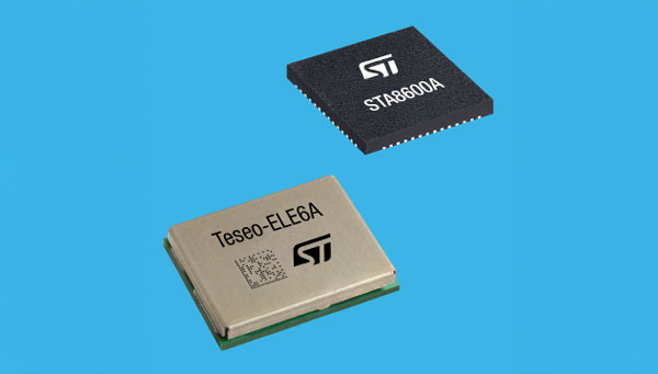
STMicroelectronics has unveiled the Teseo VI family of GNSS receivers. The new receivers integrate multi-constellation and quad-band signal processing on a single chip, achieving centimeter-level accuracy for various applications.
The Teseo VI family includes the STA8600A and STA8610A models, featuring dual independent Arm Cortex-M7 processing cores. These receivers are designed for automotive applications such as advanced driver assistance systems (ADAS) and autonomous driving, as well as industrial uses including asset tracking, mobile robots and precision agriculture.
The receivers integrate all necessary system elements for centimeter accuracy into one die, supporting simultaneous multi-constellation and quad-band operations. This seeks to simplify product development and enhance reliability in challenging conditions, such as urban canyons.
The Teseo VI+ variant can host enhanced positioning engines developed by third-party companies, providing real-time kinematics for centimeter position accuracy. The Teseo APP2 STA9200MA operates dual cores in lockstep, offering hardware redundancy for applications requiring ISO 26262 ASIL-B functional safety compliance12.
STMicroelectronics’ RF architecture and GNSS baseband design provide quad-band GNSS support (L1, L2, L5 and E6) with the ability to acquire and track only L5, improving performance in difficult conditions.
\All variants include hardware cybersecurity features such as secure boot, over-the-air firmware updates, and output-data protection. The devices comply with UNECE R155 and ISO 21434 specifications for cybersecurity by design. Two new GNSS automotive modules, the Teseo-VIC6A and Teseo-ELE6A, have been introduced to simplify integration of Teseo VI/VI+ ICs on customer platforms and ensure optimal performance.
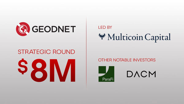
GEODNET Foundation, the organization overseeing the GEODNET positioning network, has secured $8 million in a strategic funding round. This investment, led by Multicoin Capital with participation from ParaFi and DACM, brings the project’s total financing to $15 million. The funds will be allocated to support the network’s expanding customer base and develop new applications in robotics and physical artificial intelligence.
Real-time kinematics (RTK) is a navigation technique that enhances satellite-based positioning systems to achieve centimeter-level accuracy in real time. According to GEODNET, the company has established itself as the world’s largest RTK network, with more than 13,500 user-deployed reference stations across 4,377 cities in more than 142 countries. These stations provide high-precision location services for various autonomous systems, including trucks, construction vehicles, agricultural equipment, UAVs and robotic lawnmowers.
GEODNET said its network had experienced significant growth, with its on-chain annual recurring revenue expected to increase by more than 400% compared to the previous year. This growth is attributed to the onboarding of new users, including large industrial companies, governmental organizations and enterprises.
The robotics market is projected to expand to more than $200 billion in revenue by 2030, according to studies from GlobalData. Precision location services are crucial for the training and operating of autonomous robots, UAVs and humanoid robots in complex environments. GEODNET aims to provide the necessary data for these systems to navigate safely and autonomously, both individually and in cooperative swarms.
The GEODNET network consists of reference stations that receive GNSS signals. Each station can deliver precise RTK correction data to devices within a range of approximately 20 km to 40 km. Any device equipped with a GNSS receiver — such as cars, UAVs, mobile phones, or tractors — can connect to the GEODNET network.
GEODNET supports multiple reference stations, including HYFIX’s MobileCM Triple-Band GNSS base station. Network contributors can earn GEOD tokens for hosting base stations. The GEOD token is live on the Solana blockchain, and the GEODNET Foundation is supported by several prominent blockchain and DePIN investors, including Borderless Capital, Multicoin Capital, ParaFi, DACM, CoinFund, Pantera, VanEck, Animoca Brands, Finality Capital Partners, Tangent, North Island Ventures, Modular Capital, Road Capital, Reflexive Capital, Reverie, IoTeX, JDI, SNZ and Santiago R. Santos.
GPS World spoke with Guillermo Perez-Iturbe, Trimble’s marketing director – agriculture, about the challenges for farms in adopting precision agriculture, including time, cost and connectivity issues in rural areas.
What technical challenges are faced in applying GNSS?
GNSS technology is at the center of precision agriculture and is one of the key enablers for the farm of the future. GNSS helps boost productivity, environmental sustainability and economic competitiveness.
Trimble’s GNSS agriculture solutions provide reliable, accurate positioning that can be tailored to meet specific needs, including different crops (broadacre vs. row crops) and activities (such as tilling, planting or fertilization). Trimble’s portfolio connects farming operations and includes guidance and steering; grade control, leveling and drainage; flow and application control; irrigation; harvest solutions; desktop and cloud-based data management; and correction services.
However, one of the challenges to fully realize the benefits of the future farm is connectivity. Typically, ag customers are in rural areas, where the available communications infrastructure to support Wi-Fi or cellular data communications varies widely. This can impact the ability to share information between field and office as well as between machines in the field.
But connectivity challenges have a lower impact on GNSS positioning. For example, farmers can leverage satellite-delivered corrections provided by Trimble RTX correction services using a compatible GNSS receiver and subscription service. This plays an important role in areas such as rural North America, Latin America and Australia. In many areas in Europe, farms can utilize a virtual reference station (VRS) for precise GNSS. There are also farms globally that operate their own GNSS reference networks or base stations to support accurate, high-precision, real-time positioning.
What are the remaining obstacles to adoption?
There is little resistance to the technology per se. The performance and value of precision farming are well known. Adoption rates can range from 80% to less than 40%, depending on geographic location, farm size (small family or large corporate farm), types of machines or crops, and etc.
Obstacles can come from multiple forms. For example, in some parts of the world farm staff may lack the skills or qualifications needed to operate the systems efficiently. To lower the barrier to entry, Trimble has designed intuitive user interfaces and displays based on an Android operating system. In some regions, taxation and import restrictions hinder attempts to implement GNSS into precise farming. There are also business-related issues. For example, a smaller farm must prioritize its investments, and improving or repairing a planting machine might be more important than installing GNSS technologies.
What does VerticalPoint RTK offer?
Trimble developed VerticalPoint RTK Grade Control to help farmers mitigate issues in water management and land forming. It provides centimeter accuracy in the vertical component. This accuracy level enables the precise grading needed to provide shallow flow and slow water movement.
When using VerticalPoint RTK, the GNSS rover receives and combines data from multiple reference stations to develop precise vertical measurements. It provides high confidence and can be used for grading, levees and berms, tile applications, and ditches. For larger-scale land forming based on precise terrain mapping, machines using VerticalPoint RTK can reduce the number of passes needed to bring the land to the designed grade and shape.
Do you have any other RTK services for precision ag?
The RTK technology used in Trimble agriculture solutions is consistent with RTK across other segments (construction, surveying, mapping and more). The differences are in the application and location, where we provide a variety of receivers, user displays, machine interfaces and software to produce accurate, reliable performance. The activities can range from tillage and grading to planting, adding inputs such as fertilizer or weed control — all the way through harvest. It is just a matter of talking with the farmers to understand their operations; we can then select and integrate components to optimize the solution.
As part of this, farms using Trimble RTX correction services can choose different levels of service based on their needs. This approach enables farmers to achieve (and pay for) only the accuracy they need. For example, some basic tillage operations can use RangePoint RTX with good results. Other applications, such as fertilizing row crops, may require the 2.5-centimeter accuracy provided by Trimble CenterPoint RTX corrections service.