ProStar’s PointMan software will now be bundled with Bad Elf’s high-precision GNSS receivers for worldwide sales. PointMan Precision Mapping provides a powerful cloud and mobile precision mapping solution to surveyors and geospatial intelligence systems (GIS) professionals.
This strategic partnership expands the market reach of both companies and directly addresses the growing demand for a complete mapping solution in the utility and critical infrastructure industries.
By combining Bad Elf’s advanced GNSS receivers with ProStar’s patented precision mapping solution, utility owners, contractors, municipalities and engineering firms are able to capture, record and visualize the precise location of critical infrastructure at a low cost and with a complete solution.
Bad Elf delivers accurate, compact, lightweight and cost-effective GNSS solutions compatible with a broad range of third-party vendors. Together with PointMan, the bundled solution provides customers with a comprehensive, ready-to-deploy precision mapping solution designed to reduce costs, improve efficiency and accelerate industry adoption.
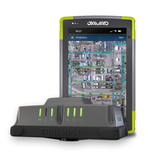
JAVAD GNSS and ProStar have announced an integrated collaboration for high-precision utility mapping and infrastructure asset tracking. The collaboration features JAVAD GNSS U.S.-made smart antennas and the mobile utility mapping software, PointMan by ProStar.
This strategic partnership expands the reach of both companies and addresses the growing demand for fully integrated and field-ready precision mapping solutions in the utility industry.
The combined solution pairs:
JAVAD GNSS smart antennas, designed and manufactured in the United States, delivering centimeter accuracy, multi-constellation support, and resilience in demanding field conditions.
PointMan by ProStar mobile software, a platform for mapping, visualizing and managing above- and below-ground assets in real time on standard mobile devices.
“Through strategic partnerships with leading hardware manufacturers like JAVAD, we are transforming the utility mapping industry,”said Page Tucker, CEO and founder of ProStar. “We see this as part of a growing trend in the industry where major hardware providers recognize they can create greater value for their customers by bundling our PointMan solutions with their hardware products.”
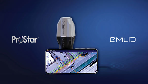
ProStar Holdings, developer of the PointMan Precision Mapping Solutions, and Emlid Tech, European maker of high-precision GNSS equipment, are partnering to bring centimeter-level precision and cost-efficiency to mapping of underground utilities and other critical infrastructure.
The strategic partnership offers ProStar’s PointMan platform, powered by Point One RTK correction services with Emlid’s lightweight and survey-grade GNSS receivers. By combining PointMan’s cloud and mobile precision-mapping solution with Emlid Reach receivers, Emlid’s end-users anywhere in the world have access to an affordable, centimeter-accurate mapping solution.
Emlid offers a range of cost-efficient and lightweight utility mapping equipment. The Emlid Reach RX is a pocket-sized high precision RTK GNSS receiver providing fast setup with no configuration required. For precision mapping trenches in challenging conditions, the Reach RS3 can be used as a base or a rover and provides centimeter-level geopositioning with tilt compensation.
PointMan with Point One RTK corrections provides an easy-to-use mobile mapping solution that uses more than 2,000 base stations communicating with all four major satellite constellations.
“We’re thrilled about this partnership,” said Dmitriy Ershov, Director of Business Development at Emlid. “PointMan mobile mapping software is well-recognized for its versatility and ease of use, and it is exciting to see PointMan continue to evolve, especially with the inclusion of Point One RTK. We are delivering survey-grade accuracy to professionals worldwide in a simple, all-in-one solution.”
Page Tucker, CEO and founder of ProStar, added, “We are strategically aligning with several leading equipment manufacturers to establish a global distribution network. Emlid’s GNSS receivers, combined with PointMan powered by Point One, create a comprehensive and affordable precision mapping solution with unmatched accuracy, coverage, and performance that empowers Emlid’s customers worldwide.”
ProStar Holdings Inc., a precision mapping company, has announced a technology integration with Leica Geosystems, part of Hexagon. The integration combines ProStar’s utility mapping software, PointMan, and Leica Geosystems’ precision GPS/GNSS receivers for GIS asset data collection.
The integration provides a precise and comprehensive data collection solution to capture, record and display the precise location of critical underground infrastructure across the globe using Leica Geosystems receivers.
“It only makes good business sense to work with other software providers and create mutually beneficial business relationships throughout the geospatial industry,” said Jason Hooten, GIS sales and support manager, Leica Geosystems.
Through the technology integration, PointMan now supports Leica Geosystems receivers for mobile devices running the Google Android operating system and Apple iOS, including the popular Zeno FLX100 plus GNSS receiver.
“The relationship adds significant value to our distribution network as Leica is recognized as a global leader in providing utility data collection solutions and precision GNSS receivers,” said Page Tucker, CEO of ProStar.
ProStar’s PointMan is natively cloud and mobile, offered as a Software as a Solution (SaaS). ProStar’s solutions are being adopted by some of the largest entities in North America, including Fortune 500 construction firms, the largest subsurface utilities engineering (SUE) firms, and government agencies.
Precision-mapping company ProStar Holdings Inc. has integrated its PointMan software into the Vivax Metrotech vLoc3 with a GNSS real-time kinematic (RTK) receiver to create a utility-locate device.
Using the RTK-Pro internal cellular module with 4G LTE capabilities, the operator can connect to the NTRIP RTK caster that provides RTCM 3 corrections.
With the integration of PointMan with the vLoc3 RTK-Pro, critical buried infrastructure can be captured, recorded and displayed at survey-grade without additional external equipment or post-processing. The integration provides centimeter accuracy of the precise location of buried utilities in real time.
Data collected includes the type of utility, the depth of cover and the utility’s precise location.
Trimble GNSS integrates with PointMan field applications to identify, capture and record the precise geospatial location of utilities
ProStar has joined Trimble’s GIS Business Partner Program. As part of the program, ProStar has implemented the Trimble Precision SDK (software developer kit) to integrate high-accuracy positioning capability in its PointMan mobile application running on smartphones and tablets using Trimble GNSS receivers.
ProStar provides field crews with an easy-to-use mobile data collection solution designed to capture, record and provide real-time visualization of the precise locations of subsurface infrastructure, while utilizing a centralized database to permanently and securely store and share utility location records in the cloud.
By adding the Trimble R Series and Trimble Catalyst receivers to the ProStar workflow, users can confidently access high-quality data and identify potential conflicts to avoid accidents, disruption of services and costly delays to infrastructure projects impacted by not knowing the precise locations of buried utilities.
“Together, Trimble and ProStar are changing the way construction companies, engineering and surveying firms as well as government transportation agencies capture, store and utilize utility infrastructure data. By leveraging the power of geospatial technology, they are able to make more informed decisions in the field,” said Stephanie Michaud, strategic marketing manager, Trimble Survey & Mapping field solutions. “Through this collaboration with ProStar, we are committed to integrating Trimble technology into ProStar’s cloud and mobile solutions to enhance safety protocols on site, reduce project costs and make a safer work environment.”
“We’re excited about this new collaboration and the integration of our PointMan software with Trimble’s high-accuracy GNSS receivers,” said Page Tucker, president & CEO of ProStar. “Creating a seamless integration with Trimble high-accuracy receivers and our PointMan software is a game-changer that will now provide one of the most comprehensive and precise field data collection solutions in the industry.”
About ProStar
ProStar specializes in the development of Precision Mapping Solutions. ProStar’s Solution is natively cloud and mobile and offered as Software as a Service.
ProStar’s Solution is designed to improve the business operations of any industry that requires the precise location of sub-surface infrastructure including utility, oil & gas, construction, engineering & surveying, 811 and contract locating.
ProStar’s Solution enables real-time access to precise location information including in the office and out in the field. Knowing the type, precise location and condition of what lies below the earth’s surface can significantly decrease liabilities and increase productivity during construction and maintenance activities.