Funding from SPRINT will enable Route Masters to collaborate with the University of Leicester on building a full suite of technology tools and algorithmic data models. This will help the company to achieve its aim of becoming the largest integrated public-transport platform for emerging African megacities.
Route Masters is developing an algorithm based on single-band GNSS positioning within cities. The solution will deliver transport flow models superimposed on satellite-based city maps. The technology utilizes applied mathematics to build digital route maps that will accurately deliver journey times and modes for city planning tools and mobile navigation applications for consumers.
This data fusion project will combine dual-band GNSS with single-band GNSS and satellite derived city maps. The solution will be leveraged to deliver planning and control intelligence services and consumer services and, after University of Leicester validation, it will be tested and deployed as an active prototype in Lagos, Nigeria.
The University of Leicester will provide Route Masters with expertise in algorithms and software development for data driven space projects as well as high-performance computational (HPC) facilities.
The project will be funded by a grant from the £4.8 million SPRINT programme that provides unprecedented access to university space expertise and facilities. SPRINT helps businesses through the commercial exploitation of space data and technologies.
“We’re a highly ambitious sustainable business with the goal of creating the largest technology-enabled data platform for transport on the African continent,” Meir Wachs, CEO of Route Masters, said. “The support of SPRINT will enable us to develop our technology in specific areas, working with the Leicester mathematics school to accelerate our development in certain key areas and to build a robust and rigorous solution that can make an actual impact on the world.”
“Projects such as this SPRINT one with Route Masters are of great benefit to the university as they enable us to engage with vibrant companies and transfer our knowledge into commercial innovative applications,” added Alberto Paganini, Lecturer in Applied Mathematics at the University of Leicester.
“We’re bringing advanced mathematical methods, data analysis and software development to the project, not only supporting the commercial development of Route Masters’ technology but also allowing us to integrate the insight gained into our curriculum to further enhance the employability skills of our students.”
Muyiwa Omopariola, Lead Transport Analyst at the Lagos Metropolitan Area Transport Authority (LAMATA) also expressed his support for the project, noting, “I greatly support technology innovation in the transport sector, especially in Lagos and across the emerging world. We look forward to seeing their continued progress.”
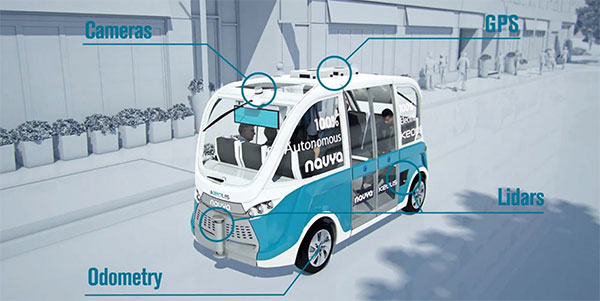
Keolis Canada and Montreal suburb City of Candiac have launched a long-term demonstration project of an autonomous electric shuttle on public roads in Canada. The shuttle will complement the public transit services currently available in Candiac.
The pilot project will take place over a period of 12 months, with about eight months dedicated to serving citizens.
This initiative was made possible through the financial support and expertise of the Quebec government and the collaboration of Propulsion Québec, the Cluster for Electric and Smart Vehicles and the Technopôle IVÉO.
Screenshot from Keolis Canada video.
The NAVYA autonomous shuttle will operate along a two-kilometer route between the park-and-ride lot and exo’s bus terminal and the intersection of Marie-Victorin and Montcalm North boulevards with several stops along the way, including City Hall, a retirement complex and local businesses.
The autonomous shuttle, which will coexist with regular traffic, will allow employees in the area to reach their workplaces from the bus terminal.
Along the route, the shuttle will go through a railway crossing and an intersection where it will communicate with four traffic lights. During the winter period, a research and development project, without passengers on board, will test how the autonomous electric shuttle adapts to Quebec winter conditions.
“This initiative is exciting because it’s the first pilot project in Canada, and the way it’s carried out will set the course for the next one,” said Marie Hélène Cloutier, vice president, Passenger Experience, Marketing & Sales for Keolis Canada. “For Keolis Canada, multimodal service is the key to the future of transportation. Autonomous electric shuttles are a great example of this because they complement existing services. The enthusiasm for this project has surpassed our expectations, which is very promising for the future.”
“We are extremely proud to be enabling Candiac residents to participate in this historic achievement,” said Normand Dyotte, mayor of Candiac. “It’s an outstanding opportunity for our citizens to be able to travel aboard the first-ever electric autonomous shuttle on a public road in Canada. We invite all public transit users and anyone who is curious or interested to come and try it now.”
Bentley Systems is a global provider of comprehensive software solutions for advancing infrastructure.
Presented by Bentley Institute, the conference is a global gathering of leading industry executives and prominent thought leaders in the design, construction and operations of the world’s infrastructure. The theme of this year’s conference is “Going Digital: Advancements in Infrastructure.”
The conference features nearly 70 speakers and more than 50 informative sessions, including keynotes by leading industry experts, interactive workshops, forums, panel discussions and product demonstrations. Attendees can visit the Technology Pavilion, which features exhibits and presentations from Bentley Systems and its strategic partners Microsoft, Siemens, Topcon and Bureau Veritas.
On the first day of the conference, Bentley Institute will host Digital Advancement Academies, featuring presentations and interactive discussions with subject matter experts who provide insights and best practices in their areas of expertise including reality modeling, BIM strategy and constructioneering.
The conference also includes the selection and announcement of the winners of Bentley’s Year in Infrastructure 2018 Awards (formerly known as the Be Inspired Awards), which honors the extraordinary infrastructure projects by users of Bentley software throughout the world.
During six industry-focused forums featured during the conference — Buildings and Campuses, Digital Cities, Industrial Infrastructure, Rail and Transit, Roads and Bridges, and Utilities and Water — more than 55 awards finalists will present their projects to independent panels of jurors, more than 100 members of the press, and conference attendees.
From those presentations, winners are selected by the jurors, and will be announced at the conclusion of the conference on Oct. 18 during an evening ceremony and gala.
Aret Garip, technical director for WSP, attended Bentley’s conference last year in Singapore to represent WSP’s One Blackfriars project in London, which was chosen as an awards finalist.
“The conference has been truly inspiring and educational,” Garip said. “It’s a great event to learn about the latest tech in engineering design software and an opportunity to meet the creative, intelligent people who develop new tools to make it easier for us to design buildings.”
In October 2019, the Year in Infrastructure Conference will return to the Marina Bay Sands Expo and Convention Centre in Singapore.
Columbus, Ohio, has positioned itself smartly for an autonomous future, taking a lead role in pilot projects on infrastructure and autonomous air and road transport.
The city will draw on up to $40 million in grants from the U.S. Department of Transportation, $10 million from Vulcan, Inc,. and $500 million in local private pledges.
Carla Bailo, assistant vice president for mobility research and business development at Ohio State University (OSU), presented the city’s ambitious program at ION GNSS+.
In “Position, Navigation and Timing — An Enabling Technology for Mobility and Smart Cities,” she focused on a triple-zero target: zero accidents and fatalities, zero carbon footprint and zero stress.
Smart Columbus will put six autonomous shuttle buses in the commercial district, coordinate truck platooning, time deliveries and manage parking to reduce congestion, and undertake drone delivery of medical supplies and other critical needs. Multimodal transit apps, mobility assistance for those with disabilities and pedestrian collision avoidance will be based on real-time data on transit options and availability, as well as traffic information, road and weather conditions.
Position, navigation and timing (PNT) technologies play a central role in smart cities: vehicle-to-vehicle and vehicle-to-infrastructure communication, autonomous navigation and collision avoidance, location-based services and smart, resilient infrastructure.
Smart Columbus envisions the city as a center for high-tech transportation research and innovation. OSU’s partnerships with mobility companies and vehicle manufacturers, industry groups and government agencies contribute to the city’s comprehensive approach to the smart city project. Through its expertise in sensors, communication, PNT, transportation, autonomous and connected vehicles, and geospatial science and engineering, OSU will serve as the lead researcher on Smart Columbus.
Dorota Grejner-Brzezinska, OSU professor and frequent contributor to GPS World, in her new role as associate dean for research at OSU’s College of Engineering will be a key participant in research projects on ways to integrate self-driving cars, deliver high-definition 3D maps and metadata, use sensors to better connect vehicles for safety and efficiency, and find better ways to move people around the city when they don’t have access to a car.
All across Europe, the number of smart cities is multiplying. To tackle their growing needs and to guarantee efficient city planning and maintenance, many cities are engaged in massive investments in such key areas as street lighting, road maintenance, traffic and waste management.
In parallel, public transportation is continuously evolving in terms of coverage, comfort and technology.
Within this context, the exploitation of Galileo and its integration with other sensors is key to developing concrete solutions for current and future smart-city planning. Along these lines, the Horizon 2020-funded GHOST (Galileo Enhancement as Booster of the Smart Cities) project is designing, developing and validating an intelligent system for vehicles that equips existing public transport fleets with a Galileo-enabled camera and connects these vehicles to a web portal.
The GHOST system equips existing public transport fleets with a Galileo-enabled camera and connects these vehicles to a web portal. (Photo: GSA)
The system automatically takes pictures of predefined points of interest (POI) based on the accurate position of the vehicle — provided by Galileo. All images are sent to a processing server capable of detecting such anomalies as potholes or a burnt-out street light. The system then uses the web portal to report these findings to the relevant authorities.
“At this point, GHOST is designed primarily for reporting street lighting anomalies and road deteriorations, monitoring public garbage collection and detecting double parking infractions or disabled parking spots occupied by unauthorized vehicles,” said Project Coordinator Claudia Maltoni. “In addition to these basic functions, we have also identified more advanced services, such as spotting bus-lane and congestion-charging-area violations, which will be implemented at a later date.”
A user-focused system
The GHOST system’s key differentiator is its use of Galileo positioning, which gives it the capability to take autonomous snapshots with an error range of 1 to 10 meters (depending on the size of the POI). In densely populated urban environments, such a level of service is only possible with the combined use of Galileo, inertial sensors and Kalman filters.
The GHOST system’s key services:
reporting street lighting anomalies and road deteriorations
monitoring public garbage collection levels
detecting double parking infractions or disabled parking spaces occupied by unauthorized vehicles
monitoring timely collection of garbage.
Another unique feature is a free smartphone application that citizens can use to collect geo-localized snapshots. “Whenever an individual user sees an anomaly within a city’s infrastructure, all they have to do is snap a picture with their smartphone,” explained Maltoni. “This level of engagement not only enhances the overall system, but also empowers individual users to play a key role in urban upkeep.”
Improving urban efficiency
By taking advantage of the many vehicle movements happening in cities every day, GHOST proposes a competitive way to improve the efficiency of monitoring a city’s operations and infrastructure. Once finalized, the system will enable faster detection of double parking or road deterioration and help reduce traffic, accidents and pollution.
“Thanks to our field tests and favourable lab results, we are already setting up the next phase of the project, with the aim of taking the system’s technology to the next level,” concluded Maltoni. “This includes providing real-time, onboard image processing so that the system can handle such dynamic scenarios as bus-lane infractions and congestion-charging enforcement.”
The project is working to bring GHOST technology to market. Coordinators are busy making key contacts with interested public administrations, garbage collection companies and traffic police departments. It is also working to ensure that the system complies with all European regulatory standards, such as those related to circulation or privacy.
Chris Urmson, Google, speaks at ITS America on the future of the self-driving car.
Plus: Resurgence in indoor location-based marketing, ITS America annual meeting report
Autonomous vehicle technology has made industry-smart people pause and think what the consequences will be if cars and other platforms drive themselves. Will there be a huge increase in traffic when everyone decides to call their cars to grab a loaf of bread at a store? Many of these topics were discussed at the ITS America annual meeting held in Pittsburgh May 31-June 3. In other location news, there seems to be a resurgence in location-based marketing and indoor positioning conferences, leading one to believe that large retailers are finally taking notice.
By Kevin Dennehy
Kevin Dennehy
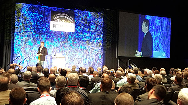
PITTSBURGH — Chris Urmson, Google’s self-driving cars director, told autonomous vehicle proponents what they wanted to hear during his keynote presentation at the recent Intelligent Transportation Society of America’s annual meeting here. He told them that self-driving vehicles will cut down on the 33,000 U.S. traffic deaths each year (“the equivalent of a 737 falling out of the sky five days a week,” he said) and save time and productivity wasted.
Urmson also said his goal, and his team’s goal, at Google was to ensure son doesn’t have to get a driver’s license, a trend that has become popular with urbanized youth.
The message was upbeat and timely for the crowd of government and university transportation attendees. However, liability issues continue to surround autonomous vehicle development.
“In the end, you are always going to have that guy with the ’57 Chevy in his garage. How do you make the autonomous vehicle work with it? It’s akin to the horse and car,” said Ken Leonard, U.S. Transportation Department ITS Joint Program Office director.
Urmson said he has had “long conversations with insurance companies.” He said that insurance companies are trying to accurately assess risk, and while the model may change, money will still flow, just through a different path.
One ITS America panel discussed security and privacy issues surrounding connected and autonomous vehicles. One panelist said that while privacy may be dead, security is the real big deal with recent reports indicating that cars’ electronics can be compromised.
Others believe it’s going to take more time than Google’s assertion that autonomous vehicles will be on the road in five years. “Lessons from the past temper our optimism. While air bags were patented in 1953, and were introduced on luxury models in the 1970s, it wasn’t until the 1990s before there were big penetrations,” said James Anderson, Rand Corp. senior behavioral scientist. “Key takeaways are automaker opposition about the liability [of new technology] and lack of consumer support.”
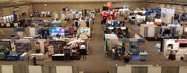
The ITS America show floor before the crowds arrive.
Anderson said that yes, the lives saved will be a big driver of autonomous vehicles, but congestion will increase, making way for super commuting. “Public transit will also go through big changes. An economic disruption will occur — do you know how much New York City makes from parking alone?” he said. “Safety doesn’t sell in the early stages, as many benefits don’t go directly to the user.”
Steve Bayless, ITS America vice president of technology, said the solution is not to kill all the lawyers, as there will be continued liability surrounding new in-car technology. “Embedded devices were developed at a time when they were not connected, but the environment has shifted around systems,” he said. “The systems are usually vulnerable because there are poor requirements. Companies have no explicit security policy, or it is poorly specified, or specified too late after design and development.”
Uber Gets Into Autonomous Game
The ITS America’s closing keynote speaker was Uber’s head of global public policy, Corey Owens, who said that one of the best cases for autonomous vehicles was the lack of use by consumers of their cars. “In some areas, owning a car is non-negotiable. But how little these cars are used — as many as 95 percent stand idle,” he said.
Uber announced that Google former head of mapping, Brian McClendon, is joining the company as it develops its own navigation, mapping and transportation systems.
It’s no secret that Uber is targeting continued autonomous vehicle interest, as it created an Advanced Technologies Center in Pittsburgh. It was also rumored that it was a bidder, with Baidu, to buy Nokia’s HERE digital mapping company. (See more on Baidu in Janice Partyka’s June blog.)
One major company trying to find its way into connected vehicles, Xerox, exhibited at ITS America in the show’s Entrepreneurial Village. Xerox has installed its smart parking products in such systems as LA Express Park, ParkyIndy and others.
Xerox has partnered with the University of Michigan Transportation Research Institute in Ann Arbor for testing connected and autonomous vehicles. The company is working with automotive OEMs on electronic tolls, parking, mobile payment and other projects, said David Cummins, Xerox senior vice president and managing director of parking and mobility solutions.
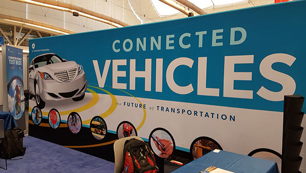
The U.S. Department of Transportation booth at ITS America focused on the connected car.
Cummins moderated a panel where small companies talked about new technologies and applications like cities without bus stops where a bus is continually moving to the riders on demand.
In terms of autonomous vehicle use, Cummins envisions an increase in ride-sharing over the next 5-10 years in urban areas. “Initially, there will be a spike in congestion [from autonomous vehicles]. But ultimately, there will be less car ownership,” he said.
Thoughts on ITS America’s Annual Meeting
ITS America celebrated its 25th annual meeting in Pittsburgh to an enthusiastic crowd of 2,000 attendees and 125 exhibitors. However, I am not sure if this conference has grown at all, despite claims it had the largest attendance last year (co-located with the larger, and more private-company-friendly, ITS World Congress in Detroit).
Despite two decades of rhetoric that it is a private-public partnership, the meeting has the feel of a government and university gathering with a few private companies thrown in who want to do business with them. This is a sad thing, as ITS America has embraced the future of autonomous vehicles with excellent speakers.
Having the meeting in the Bay Area next summer will be a good start to altering the perception that ITS America’s annual meeting is just a government show to “show-the-flag” for private companies.
Mid-Year Report on Indoor Location
Earlier this month, executives attended the Place Conference in New York to get an update on indoor location markets and technology for store chains, large department stores and malls. It was also a chance for technology vendors to show new capabilities that have recently reached the market, said Bruce Krulwich, Grizzly Analytics president, who has authored a report on 150 indoor positioning companies.
Krulwich said, as the year reaches it’s the halfway point, new and more accurate systems are hitting the market. “This includes LED lighting-based systems from Acuity and GE Lighting, and proprietary radio technologies from companies like Quuppa, all of which deliver accuracy of around 10 centimeters with very fast response,” he said. “Some companies, including New York-based Spreo, are improving the quality using standard approaches, like beacons and motion sensing. They are achieving strong accuracy and responsiveness through software improvements. At the same time, hardware-based indoor location technologies, such as Ireland-based DecaWave’s chip and other UWB systems, are coming to market inside highly innovative consumer devices.”
Going forward, the biggest challenge is moving from the lab to the real world, Krulwich said. “Deployments such as Game Stop stores and Taubman malls are great moves in this direction,” he said.
In other location industry news:
Note to meeting organizers: Do your due diligence to ensure conference dates don’t overlap. Having two major transportation conferences on the same week was challenging to attend: ITS America Annual Meeting and Telematics-Detroit.
The brass at Nokia continue to court a consortium of German car makers to buy its HERE navigation business, according to Bloomberg. The consortium, which consists of Audi, BMW and Daimler, is hung up on the price tag of $4.5 billion — and the deadline for bidders has passed, according to the story.
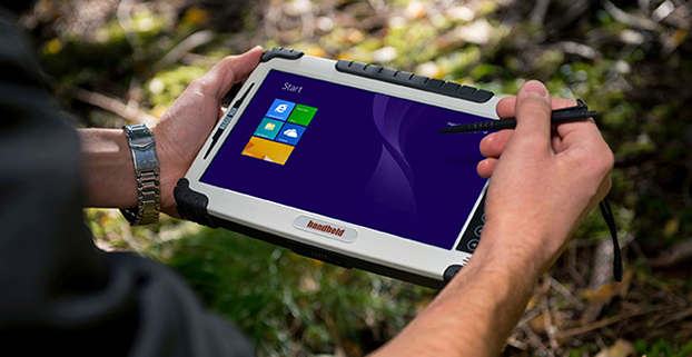
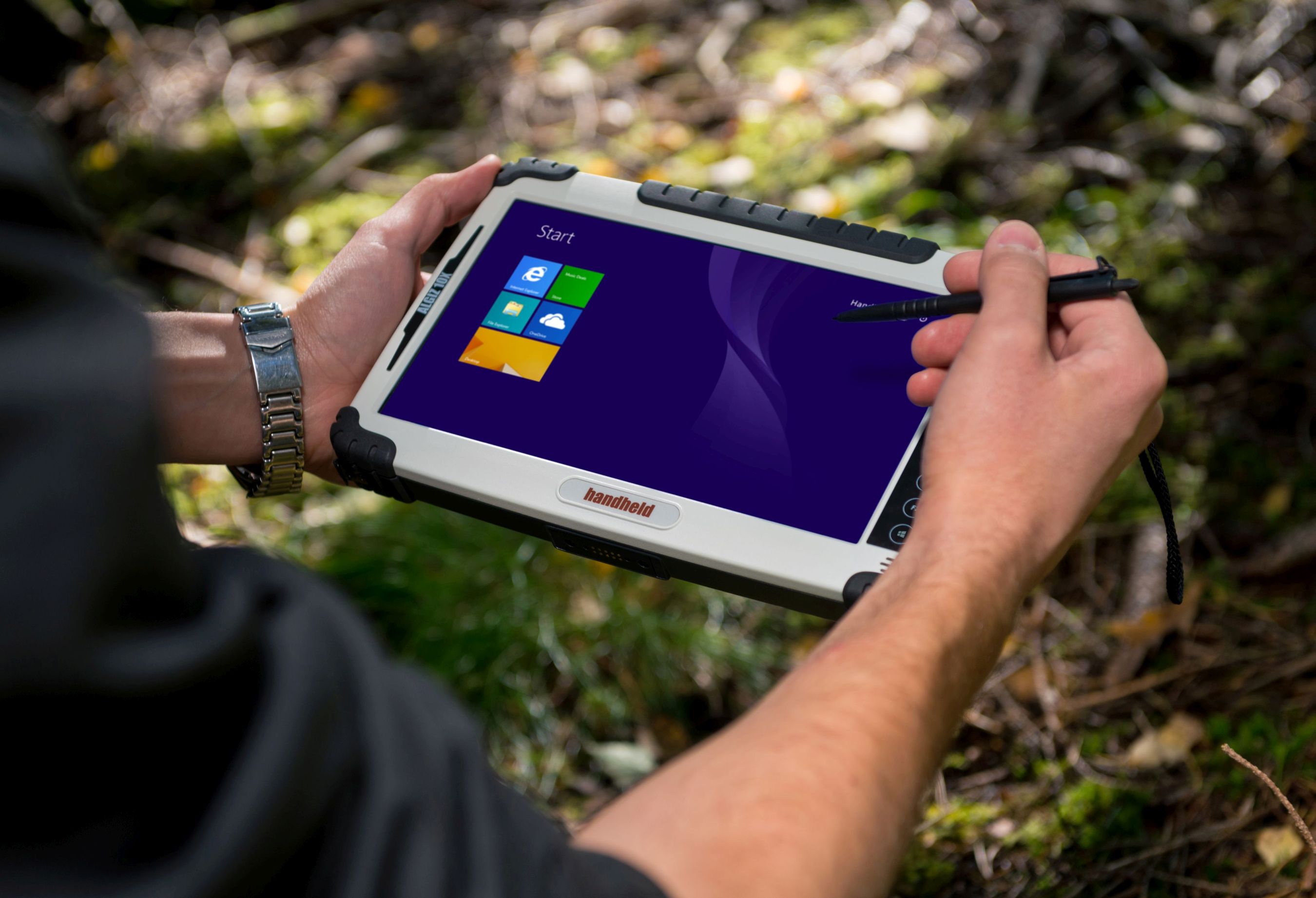
Handheld’s Algiz 10X rugged tablet now has Windows 8, a faster processor.
Handheld Group is upgrading its Algiz 10X tablet. With the upgrade, the rugged tablet for field professionals now features the Windows 8.1 Pro operating system, which is downgradable to Windows 7. Windows 8.1 Pro offers enhanced features to help users connect to company networks, access one PC from another, encrypt data and more.
The upgraded Algiz 10X also has a more powerful processor that speeds startup and operation, increases software compatibility and doubles processor performance. Its has an integrated u-blox GPS receiver with WAAS/EGNOS/MSAS capability.
Like all of Handheld’s rugged PDAs, smartphones and mobile computers, the Algiz 10X is specifically developed for field workers in industries such as geomatics, logistics, forestry, public transportation, utilities, construction, maintenance, mining, military and security. It is IP65-rated and meets stringent MIL-STD-810G military standards — protected against dust, water, vibrations, drops and extreme temperatures. It has a 10.1-inch touchscreen, weighs 1.3 kilograms (2.9 pounds) and is 32 millimeters (1.2 inches) thick.
“By using the very latest operating system available from Microsoft, customers can now enjoy quicker startup and operation, increased software compatibility and improved support for touchscreen-based tablets, among other benefits,” said Johan Hed, Handheld’s director of product management.
The new Algiz 10X also has the powerful Intel quad-core N2930 1.83 GHz processor with 2.16 GHz boost. This processor allows for both higher performance and cooler running temperatures. Compared to the Algiz 10X’s previous processor, the N2930 more than doubles performance benchmarking, RAM support, number of cores and performance per watt.
“We have dramatically increased performance levels without sacrificing operating time or mechanical design,” Hed concludes. “We have also improved our wireless communication support. Besides 802.11 b/g/n on 2.4 GHz, we now support both 802.11ac and 802.11a on 5 GHz. The upgraded Algiz 10X also supports LTE, which provides substantially faster data speeds, both up- and downstream, and increased overall network coverage.”
Key features of the Algiz 10X version 2:
Powerful Intel quad-core N2930 1.83 GHz processor
128 GB SSD, expandable via microSD
4 GB of DDR3 RAM
Windows 8.1 Industry Pro (downgradeable to Windows 7)
10.1-inch touchscreen with high-brightness MaxView screen technology
IP65 rating and conformity to stringent MIL-STD-810G test standards
LTE capability with a fully integrated modem and antennas
Integrated u-blox GPS receiver and WAAS/EGNOS/MSAS capability
Antenna pass-through connectors for both GSM and GPS
Several connectivity options, including WLAN and BT, USB 2.0 and USB 3.0, VGA and RS232 ports
The upgraded Algiz 10X is available now and orders can be placed immediately.
According to a new research report from the analyst firm Berg Insight, the market value for Intelligent Transport Systems (ITS) deployed in public transport operations in Europe was €0.76 billion in 2011. Growing at a compound annual growth rate of 15 percent, this number is expected to reach €1.5 billion by 2016. Berg Insight is of the opinion that the European market for ITS for public transport is in a growth phase which will last for several years to come.
In a statement, Berg Insight said the fluctuating economic climate has in most countries had little effect on the market as the public investments which underpin a major part of the ITS initiatives have remained stable throughout the periods of crisis. The vendor landscape for public transport ITS consists of a variety of actors. The companies INIT, Trapeze Group and IVU have emerged as leaders in Europe, having broad product portfolios and large numbers of installed systems in many countries. There are also local players with considerable market shares on regional markets in Europe, including Ineo Systrans and Vix. Another group of vendors are focused on specific parts of complete ITS such as specialized hardware units or software applications.
”The public transport ITS market in Europe is favored by several concurrent developments, including UITP’s sought-after doubling of the public transport ridership, the EBSF EU project, and generally higher expectations among travelers,” said Rickard Andersson, telecom analyst, Berg Insight. “Increasingly sophisticated solutions for traffic management and passenger information are available which – if implemented correctly – eventually can put public transport on par with private transportation modes in terms of traveling times and flexibility.” Andersson adds that a noteworthy development is the increasing integration of smartphone-based solutions in public transport ITS, used for various traveler-centric applications as well as business performance overviews for operators, and most recently also as affordable tracking solutions enabling real-time passenger information (RTPI). “Travelers increasingly expect real-time information also from smaller operators with low propensity to invest in ITS,” concluded Andersson.