QinetiQ-led Team Elaris has been awarded a £6 million contract with the UK Ministry of Defence (MOD) to develop a deployable solution concept for enhanced long-range navigation (eLoran).
Work completed under the two-year Urgent Compass program will be used to inform future demonstration, production and deployment packages of work.
The UK and its allies rely heavily on position, navigation and timing (PNT) for effective military operations. PNT solutions traditionally use GNSS signals, but these can be jammed or spoofed by adversaries in battlefield environments. A jammed or spoofed satellite navigation signal, if undetected or uncorrected, can result in misdirected troop movements or incorrectly guided missile trajectories, leading to mission failure in the battlefield arena.
Militaries are increasingly looking for alternative, more resilient PNT solutions to enhance and complement traditional GNSS, such as eLoran which is a terrestrially based alternative and can operate when access to satellite PNT is denied. This program extends QinetiQ’s engagement with MOD on assured PNT solutions, which includes the Robust Global Navigation System (RGNS) program — another key component in UK MOD’s approach to resilient PNT.
Urgent Compass will explore eLoran based solutions that can be quickly deployed into contested locations worldwide.
Team Elaris is made up of QinetiQ, UrsaNav, Roke and GMV. Each organization brings technical knowledge and domain expertise in PNT technologies to the partnership, which is exploring both deployable and fixed eLoran solutions.
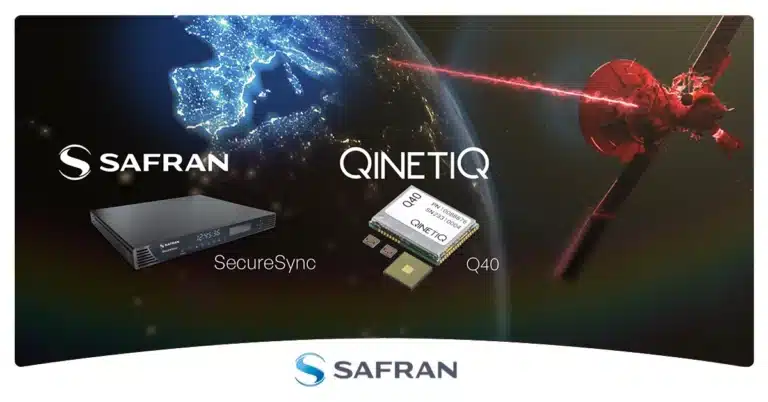
Safran Electronics & Defense and QinetiQ have entered a strategic partnership to deliver sovereign and resilient positioning, navigation and timing (PNT) solutions for the United Kingdom Ministry of Defence. The collaboration addresses today’s urgent need for trusted PNT capabilities in increasingly challenging and GNSS-denied operational environments.
By integrating QinetiQ’s Q40 GNSS receiver with Safran’s SecureSync time server, the partnership offers advanced protection against jamming, spoofing and other adversarial electronic warfare threats. The joint solution supports multi-signal reception and delivers reliable, coherent synchronization for mission-critical military operations — from strategic headquarters to frontline forces.
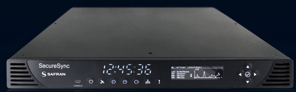
The SecureSync time server. (Photo: Safran)
This next-generation, sovereign capability strengthens the UK’s operational advantage, ensuring continuous access to secure timing and navigation, even under electronic attack. The solution is designed to adapt and expand, accommodating future threats and supporting the full spectrum of defence operations.
“The Q40 provides navigational assurance in environments where jamming, spoofing and electronic attacks are ever-present,” said James Willis, chief executive UK Intelligence, QinetiQ. “By pairing it with Safran’s SecureSync, we are giving UK forces a trusted, sovereign solution that ensures precise timing and navigation data remains available when it matters most.”
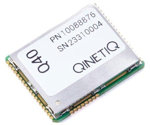
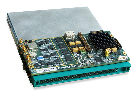
The Q40 GNSS receiver. (Photo: Qinetiq)
“In the current context of evolving threats and contested environments, guaranteeing sovereignty in navigation and timing is more critical than ever for national defence,” added Maxime Gorlier, director of PNT Business Unit for Safran Electronics & Defense. “This partnership enables UK armed forces to maintain full independence and sovereignty, even when facing sophisticated electronic warfare tactics. Together, we are committed to providing future-proof PNT solutions that strengthen the UK’s resilience and strategic autonomy.”
The partnership leverages both companies’ sustained investment in customer-focused research, development and innovation, and demonstrates their shared commitment to providing robust, secure and resilient PNT solutions.
QinetiQ and Xona Space Systems have demonstrated how GPS navigation can be bolstered by using low Earth orbit (LEO) satellites, in the first UK tests of Xona’s new satellite navigation system, Pulsar.
This marks a major milestone in the development of next-generation positioning, navigation and timing (PNT) capabilities, increasing resilience against jamming and spoofing, as well as improving GPS availability in congested or challenged environments.
In the tests, QinetiQ’s Q40 multi-constellation GNSS receiver acquired and tracked signals from Xona’s first production-class satellite, Pulsar-0. The tests demonstrated that, by supplementing GNSS with LEO satellite signals like the Pulsar X1, enhanced resilience in contested or poor-signal environments can be achieved.
A recent software upgrade to QinetiQ’s Q40 was developed under the European Space Agencies’ Navigation Innovation and Support Program (NAVISP) in the GNSS Receiver with Advanced Pulsar Enhancement (GRAPE) project.
GRAPE is a collaboration between QinetiQ and Xona, supported by the UK Space Agency and European Space Agency. Its goal is to explore how new LEO-based signals can be integrated with existing GNSS, to enhance the accuracy and resilience of navigation services for defense, critical infrastructure and future autonomous applications.
“For the first time, we have demonstrated how signals from new LEO satellites can be used alongside existing GNSS to give users stronger, more resilient timing and position information,” said Chris Walker, Managing director, Mission Systems Division, QinetiQ. “This is a huge step in increasing the protection of our defence, critical infrastructure and future autonomous systems against interference.”
The UK Ministry of Defence will construct a new anti-jamming test facility at Boscombe Down in Wiltshire, England. This facility is designed to safeguard military equipment from threats posed by GPS jamming. A £20 million ($26 million) contract has been awarded to the defense technology firm QinetiQ, which will create one of Europe’s largest anechoic chambers, set to be operational by 2026.
This facility, referred to as a “silent hangar,” will accommodate large military assets such as Protector UAVs, Chinook helicopters and F-35 fighter jets, allowing for comprehensive testing against electronic warfare threats. Maria Eagle, the minister for defense procurement and industry, said that this facility will help eliminate vulnerabilities in military systems, thereby enhancing national security and better protecting armed forces during global deployments.
The hangar will be engineered to minimize radio-frequency wave leakage, ensuring that testing does not interfere with local emergency services and air traffic control. Additionally, according to the UK Ministry of Defence, the project is expected to generate 20 new jobs in the Boscombe Down area and will support broader applications beyond defense, benefiting various sectors of government and industry.
QinetiQ and its partner Collins Aerospace have won a £67 million contract with the United Kingdom’s Ministry of Defence (MOD) Defence Equipment and Support (DE&S) to develop multi-constellation satellite receivers under the U.K. Robust Global Navigation System (R-GNS) program.
The program will deliver critical capability to provide UK Defence with accurate and resilient positioning, navigation and timing (PNT), which will underpin the UK’s ability to undertake 24/7 military operations around the world in demanding and increasingly contested operational environments.
QinetiQ, working with its partner (Collins Aerospace) and sub-contractors (Roke Manor Research, Raytheon Systems Limited, Garfield Microelectronics, Nottingham Scientific Limited, Phixos and a number of other specialist suppliers and manufacturing partners) will work together to provide advanced navigation products that are UK sovereign supplied, low size, weight and power (SWAP) delivering high-accuracy, resilient and secured operational capability.
The use of multi-constellation, multi-service satellite navigation signals, multiple sensors and QinetiQ’s advanced processing technologies will enable secured navigation, ensuring that users and platforms —autonomous land, maritime, air and weapons systems — will be able to navigate accurately, robustly and safely.
“Whether it’s soldiers conducting operations in remote environments or fighter jet pilots flying in contested airspace, our Armed Forces depend on satellite navigation technology,” said Defence Minister Anne-Marie Trevelyan. “These state-of-the-art receivers will help to ensure our armed forces can defend UK interests wherever and whenever they are threatened.”
“Ensuring that UK Forces have the best and most resilient secured navigation capabilities is essential to ensuring that they are able to operate effectively in increasingly challenging operational environments,” Steve Wadey, CEO, QinetiQ said. “We are extremely pleased to be working with MOD, DE&S and DSTL to deliver this critical capability. This programme will exploit QinetiQ’s advanced technologies and, working collaboratively with our partners across the supply base, deliver substantial operational advantage for UK Defence.”
The delivery date for the first R-GNS products is February 2022.
Remotely controlled Javelin firings can help keep soldiers out of harm’s way. (Photo: Lockheed Martin)
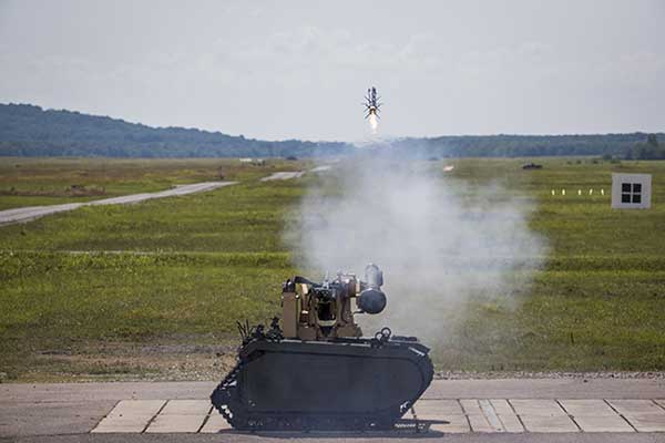
The Javelin Joint Venture team, a partnership of Raytheon Company and Lockheed Martin, successfully fired Javelin missiles from a Kongsberg remote launcher mounted on a Titan unmanned ground vehicle built by QinetiQ North America and Milrem Robotics.
The demonstrations, conducted at the U.S. Army Redstone Test Center, Alabama, validated the integration of the weapon station, missile and vehicle.
“Javelin is ready to support emerging military robotic vehicle requirements,” said Sam Deneke, Raytheon Land Warfare Systems vice president. “Remotely operated technology like this protects soldiers in battle.”
Javelin has been fielded on the Common Remote Operations Weapon Station-Javelin across U.S. Army Stryker 8×8 vehicle brigades in Europe.
“Javelin offers true fire-and-forget engagements to 4 kilometers in most operational conditions,” said David Pantano, Javelin Joint Venture vice president and Lockheed Martin Javelin program director. “Once the launch command is issued, soldiers and vehicle assets like the UGV can reposition out of harm’s way. These tests demonstrated our ability to evolve Javelin capabilities to address new missions in support of the warfighter.”
Javelin is a versatile one-man-portable and platform-employed anti-tank and multi-target precision weapon system. The Javelin Joint Venture team has produced more than 45,000 Javelin missiles and 12,000 command launch units. The program continually updates the system to stay ahead of advancing threats, including enhancing its platform-mounted capabilities.
U.S. and coalition forces have used Javelin extensively in Afghanistan and Iraq in more than 5,000 engagements.
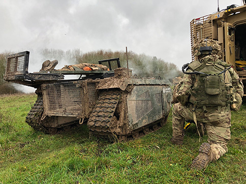
In December 2018 near Salisbury, England, four Milrem Robotics’ and QinetiQ TITAN unmanned ground vehicles (UGVs) were put through three weeks of rigorous tests by British troops during the Army Warfighting Experiment 2018 (AWE18).
The goal was to determine how new unmanned technologies can enhance soldier’s survivability and effectiveness on the modern battlefield.
The modular base can be adapted for various missions, including casualty retrieval. (Photo: Milrem Robotics)
The test was conducted in three phases: conduct combat operations without the benefit of new technologies; conduct combat operations using new technologies but without changing tactics; and, lastly, conduct combat operations using new technologies and adapting tactics according to the capability that the new technology provides.
The UGVs were used in a number of different roles with missions conducted in urban, open and forested terrain.
In remote-control mode, a command-and-control station allows the operator to receive real-time sensor data from the UGV and to transmit command data to the vehicle through a tactical data link. Various third-party sensor packages can be installed.
Of the four Milrem UGVs, two were deployed by Milrem Robotics and two by QinetiQ. The Milrem-fielded systems included one configured as a casualty evacuation and logistical support unit and a second unit equipped with a tethered multi-rotor drone pod provided by Threod Systems.
One of the four UGVs was TITAN Strike, a prototype system carrying a Kongsberg remote weapon station, fully controlled by a remote operator and using QinetiQ’s Pointer system as a means of integrating the capability with dismounted infantry.
The second system, TITAN Sentry, also enabled with Pointer, featured a Hensoldt-provided sensor suite including electro-optical and thermal-imaging cameras and a battlefield radar.
Rockwell Collins and QinetiQ have signed a global alliance agreement to collaborate on the development of next-generation, multi-constellation open-service and secure GNSS receivers.
The effort will support the mission needs of military, government and critical national infrastructure.
The family of receivers being developed will provide military, government and professional users the flexibility of selecting relevant GNSS capability to meet operational, geographical or budgetary needs and provide GNSS accuracy and timing.
This will improve safety, increase mission effectiveness and reduce operational costs for ground troops, vehicles and high-dynamics GNSS-guided weapons, Rockwell Collins said.
Rockwell Collins is major contractor for secure military GPS receivers and QinetiQ is an expert in the field of open-service solutions with access to critical satellite navigation system technologies that enable the development of multi-constellation solutions.
“This alliance agreement with QinetiQ is a great opportunity to bring together our strengths,” said Colin Mahoney, senior vice president of international and service solutions for Rockwell Collins. “Working together, our customers will experience unprecedented levels of availability, accuracy and assurance of positioning, navigation and timing for conducting their missions.”
“As we move into the era of multi-constellation satellite receivers, this market-leading agreement and the investments of both companies sends a clear message to our customers and shareholders that QinetiQ and Rockwell Collins are taking every step necessary to stay at the forefront of GNSS technical development and product delivery,” said Steve Wadey, CEO of QinetiQ. “The development will be centered in Europe, led from the U.K., supporting the global market.”
QinetiQ today announced a major breakthrough in developing a robust navigation receiver that will use the Galileo, Europe’s satellite navigation system — in particular, the secured Public Regulated Service (PRS).
QinetiQ’s new high-performance, next-generation GNSS receiver is multi‑constellation and multi‑frequency, and is designed to process encrypted signals from the Galileo PRS service as well as open services such as GPS. Qinetiq introduced the receiver today at the UK Space Conference, being held July 13-15 in Liverpool.
The receiver — now a in prototype form — is a significant step towards developing an end-user product for navigation, tracking and timing, QinetiQ said. It will offer highly secure, accurate and reliable position, velocity and timing intended for users with a mission-critical need such as governments, the military and emergency services across Europe.
“We are delighted that, after years of QinetiQ R&D and collaboration with the EU, European Space Agency (ESA) and UK government, we have achieved this major step towards our goal of offering robust navigation products using Galileo,” said Nigel Davies, head of QinetiQ’s Secured Navigation Group. “It is a significant breakthrough for us to have built a fully operational receiver on a platform, which proves our product architecture, functionality and algorithms.”
“Our next step will be working to refine the product family and preparing it to be brought to market, which includes developing additional features and reducing its size to that of a postage stamp, in a form factor similar to our existing, highly successful Q20 receiver,” Davies said. “We have full confidence in this product and are proud to be at the forefront of this exciting new phase in European navigation.”
The prototype receiver is a multi-constellation, multi-frequency, all‑in‑view receiver that can receive and process the Galileo PRS as well as Galileo Open Service and GPS Standard Positioning Service. It is also designed to utilize other GNSS signals including the Russian GLONASS and Chinese Beidou systems as well as space-based augmentation services (SBAS) such as WAAS and EGNOS.
The receiver, which is based on the military standard SEM-E form factor, is also designed for integration into multi-sensor navigation systems and is designed to provide high levels of protection against jamming and spoofing. It has a fast acquisition capability and is designed for government security accreditation.
It is expected that a suite of robust products will be ready by 2020 to coincide with the completion of the Galileo project, which will be the world’s third GNSS to be completed after the United States and Russian systems.
The new receiver is part of a long pedigree in robust GNSS receivers. Q20 was QinetiQ’s first GPS receiver, designed for specific challenging applications: high dynamics, or high sensitivity like tracking from inside a shipping container. QinetiQ’s family of receivers will include two new products based on the new receiver. Q40 will be QinetiQ’s next-generation robust open service receiver, which will be a multi‑constellation, multi‑frequency open-service receiver which can use signals from all of the GNSS open services. Q50 will incorporate all of the functionality of the Q40 receiver, but also offer Galileo PRS for authorized users who need the additional capabilities and robustness.
“The device we have built is a major stepping stone to Q40 and Q50 as the technology has all been built for the receiver products and is designed to be shrunk on to a single ASIC microchip,” Davies said. “Our focus of attention will now be to turn what we have built into an ASIC product which is ready for market.”
On August 30, QinetiQ and Rockwell Collins demonstrated the first joint satellite navigation positioning using live signals from the encrypted governmental services from the U.S. Department of Defense (DOD) GPS Precise Positioning Service (GPS-PPS) and the new European Galileo Public Regulated Service (PRS). The signals on GPS L1 and L2, together with Galileo PRS L1A and E6A, were processed and combined to form multi-frequency, multi-constellation position fixes.
Positioning, navigation and timing (PNT) services provided by GNSS, such as GPS and the forthcoming Galileo system, are essential to underpinning both commercial and economic activity (the EC estimates 6-7% of the developed world’s GDP) and the delivery of governmental responsibilities including the safety and security of citizens.
GNSS systems such as GPS and Galileo make use of very low power signals and are subject to inadvertent interference, deliberate jamming and spoofing (where an attacker generates a false signal masquerading as a valid one to mislead a user receiver). Attacks on GNSS may range from low-level criminal nuisance (a delivery driver stopping their employer tracking them), enabling theft of high-value vehicles fitted with trackers, through to state-sponsored attacks. This is potentially a significant concern for a wide range of governmental users including law enforcement, security and emergency services, critical national infrastructure, transport and defense users. The use of multiple independent, secured navigation services provides significant improvements to navigation robustness and, along with other measures, offers substantial counters to these threats.
“This has been our first opportunity to explore how secured navigation services on GPS and Galileo can be used together to provide users with critical reliance on PNT with robust and continuous navigation services,” Nigel Davies, Head of QinetiQ’s Secured Navigation Group said. “QinetiQ is proud to be a key, long-term contributor to the Galileo Programme, having been working closely with the European Space Agency (ESA), the European GNSS Agency (GSA), European industrial partners and European Member States since 2003. QinetiQ and Rockwell Collins wish to thank ESA, the EC and GSA for support in accessing Galileo, as well as the UK Space Agency, UK Satellite Applications Catapult and the UK MOD for their support.”
QinetiQ and Septentrio jointly announced today that a milestone in the Galileo European Navigation Satellite System’s development and deployment program has been achieved. On March 12, staff at the European Space Agency at ESTEC, Noordwijk, The Netherlands, achieved the first navigation solution using only the encrypted Galileo Public Regulated Service (PRS) signals broadcast by the four Galileo In-Orbit Validation (IOV) satellites launched in 2011 and 2012. Septentrio and QinetiQ, working in close partnership, developed one of the two PRS test user receivers used in this historic first test.
PRS positioning was achieved using the Galileo PRS Test User Receiver (TUR-P) jointly developed by Septentrio and QinetiQ under an ESA contract. For the reception test, the receiver was installed in the PRS test facility in ESTEC and operated by technical experts from ESA. Positioning accuracy of ~10 meters was achieved, excellent for a first test so early in the system’s deployment. The TUR-P now continues to be used as part of the campaigns running during the Galileo In Orbit Validation Phase.
This milestone builds on a number of previous major Septentrio/QinetiQ achievements including:
First laboratory demonstration of the PRS signal acquisition and tracking in QinetiQ (Malvern, UK, 2006).
Successful RF compatibility test between a Galileo payload and the TUR-P (Portsmouth, UK, 2010).
Successful Galileo end-to-end system test including the Galileo Ground Mission Segment (GMS) and its key management facilities, satellite and TUR- P (Rome, Italy, 2011).
First successful reception and processing of the PRS signal from space (Fucino, Italy, 2012).
As key, long-term contributors to the Galileo program, Septentrio and QinetiQ have worked closely with ESA, the European GNSS Agency (GSA) and European industrial partners since 2003.
“Following last year’s first successful reception and processing of PRS signals from Galileo satellites, I am very pleased to see the program moving forward successfully,” said Leo Quinn, CEO of QinetiQ. “Achieving a first PRS-only Galileo navigation solution is a major achievement. With positioning, navigation and timing services increasingly critical to the safety, security and economic activity of UK and our European neighbours QinetiQ are very proud to be contributing to the development of Europe’s first secured satellite navigation services.
“This milestone is another important step towards the launch of operational Galileo services and will continue to build confidence in both prospective users and the industrial supply base. It showcases QinetiQ’s capabilities in this field and signals the way towards the production of exciting new solutions for critical navigation and timing applications.”
“Today, together with our partners, we take another decisive step in the early availability of commercial PRS receivers and Septentrio is extremely proud of this historic milestone for the Galileo program,” commented Peter Grognard, Septentrio’s founder and CEO. “This builds on a list of major achievements for Septentrio since the reception of the first Galileo signal from space in 2006. We are delighted to continue the excellent collaboration with ESA and to contribute to this ambitious European project.”


 QinetiQ