The EUMETSAT Polar System is considering providing GNSS navigation bit data, should there be sufficient interest in the user community.
“In the framework of the development of the radio occultation data processor for the new EUMETSAT Polar System – Second Generation mission, we envisage a GNSS Navigation Bit Data product,” wrote Riccardo Notarpietro, a remote sensing scientist with EUMETSAT’s radio occultation team, in an email.
“This product will contain the bit stream of each of the GNSS navigation messages which are modulating the open service GNSS signals. We are thinking to provide this product operationally on an hourly base covering the last hour of observations from a dedicated ground-based network of GNSS receivers.”
If there is sufficient interest, the data would be made available from the EUMETSAT data distribution system. Notarpietro invites those who are interested or have questions to contact the team at [email protected].
EUMETSAT is the European Organisation for the Exploitation of Meteorological Satellites. The second-generation of the polar system, also known as EPS-SG, will secure the continuation of meteorological observations from polar orbit in the 2022-2043 timeframe.
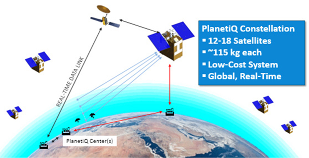
PlanetiQ has signed a contract with Antrix Corporation Limited, the commercial arm of the Indian Space Research Organization (ISRO), for the launch of PlanetiQ’s first two weather satellites on a Polar Satellite Launch Vehicle (PSLV) during the fourth quarter of 2016.
Ten more satellites are planned for launch in 2017 to complete an initial set of 12 satellites that will dramatically improve global weather forecasting, climate monitoring and space weather prediction, and enable advanced analytics for numerous industries worldwide.
The ISRO’s PSLV is among the world’s most reliable launch vehicles with 30 consecutive successful flights. It has launched 51 satellites for international customers from 20 countries, in addition to 33 Indian national satellites.
“The stellar track record of the PSLV combined with our seven-year satellite design life provides the reliability and data continuity not just desired, but required by the operational weather forecast community,” said Chris McCormick, Chairman and CEO of PlanetiQ. “Within days after launch, we will validate and start delivering high-quality data and services to our customers.”
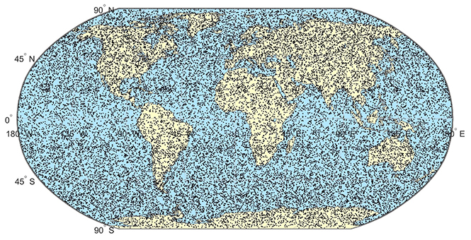
24 hours of data from 12 PlanetiQ satellites = ~34,000 occultations/day.
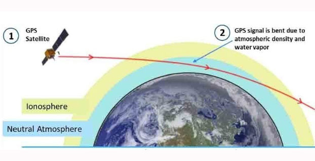
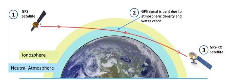
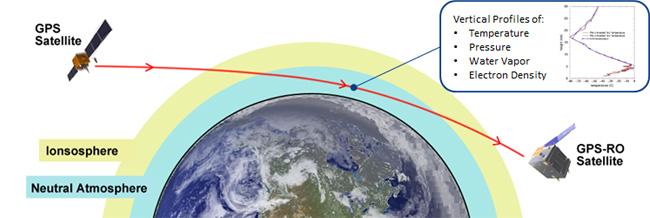
Each of PlanetiQ’s 10-kilogram microsatellites will fly PlanetiQ’s Pyxis-RO sensor, an advanced satellite weather sensor in a small package that can penetrate through clouds and storms down to the Earth’s surface. Pyxis-RO uses a technique called radio occultation to track the bending of GPS and other signals as they travel through Earth’s atmosphere, and then converts the bending angle into high-precision measurements of global temperature, pressure and water vapor in the atmosphere, and electron density in the ionosphere.
Pyxis-RO quadruples the data collection capability of radio occultation sensors on orbit today by tracking signals from all four major satellite navigation systems — GPS, Galileo, Beidou and GLONASS. With 12 satellites on orbit, PlanetiQ will collect 34,000 occultations per day, evenly distributed around the globe with high-density sampling over both land and water.
Each occultation is a vertical profile of atmospheric data with high vertical resolution, comprised of measurements less than every 200 meters from the Earth’s surface up into the ionosphere. The data is similar to that collected by weather balloons, but more accurate, more frequent and on a global scale.
“The world today lacks sufficient data to feed into weather models, especially the detailed vertical data that is critical to storm prediction. That’s why we see inaccurate or ambiguous forecasts for storms like Hurricane Joaquin, which can put numerous lives at risk and cost businesses millions of dollars due to inadequate preparation or risk management measures,” McCormick said. “Capturing the detailed vertical structure of the atmosphere from pole to pole, especially over the currently under-sampled oceans, is the missing link to improving forecasts of high-impact weather.”
PlanetiQ has selected Blue Canyon Technologies to build its weather satellite constellation, set to launch in 2016 and 2017. PlanetiQ chose BCT as a partner in developing the world’s first commercial constellation dedicated to weather, climate and space weather based on BCT’s development track record and its cutting-edge, low-cost design approach that has delivered hundreds of components and systems for numerous space missions, PlanetiQ said.
“Weather is the next commercial space frontier, as demand grows not only for better forecasts of day-to-day weather, severe storms and hurricanes, but also for weather and climate data solutions that enhance weather readiness, support risk management and increase business intelligence,” said Anne Hale Miglarese, president and CEO of PlanetiQ. “Together, PlanetiQ and BCT bring the innovation, technical expertise and experience to cost-effectively produce the high-quality data needed to transform the weather satellite industry and deliver unprecedented economic value.”
PlanetiQ has co-located its aerospace engineering team at BCT’s Boulder facilities, where both the satellites and sensors will be manufactured and integrated, and is already working side-by-side with BCT on the initial set of 12 microsatellites. Working together with the PlanetiQ team, BCT has dramatically reduced the satellite size and weight without sacrificing any instrument capabilities.
“We are certainly pleased to be chosen by PlanetiQ. Weather is emerging as a major growth sector for aerospace, and our partnership with PlanetiQ positions BCT and the state of Colorado to play a leading role,” said George Stafford, president and CEO of BCT. “Our systems and components match well with PlanetiQ’s instrument requirements, and we are glad to be working on this spacecraft and mission.”
In early June, PlanetiQ announced the successful testing of its first “Pyxis” weather sensor and is setting up for production with BCT. Pyxis collects dense, precise measurements of global temperature, pressure and water vapor — similar to data collected by weather balloons but on a global scale — using a technique called GPS Radio Occultation (GPS-RO). Among the satellite data sources currently ingested into computer weather models, GPS-RO has shown the most cost-effective, highest impact per observation on forecast accuracy. But only a sparse amount of GPS-RO data exists today.
Pyxis is the only GPS-RO sensor in such a small package that is powerful enough to provide more than 10 times the amount of data available from GPS-RO sensors currently on orbit, and to routinely probe down into the lowest layers of the atmosphere where severe weather occurs.
“The small size and weight of the Pyxis sensor — combined with BCT’s high-performance mission experience — will allow us to quickly field a constellation to provide the highest quality, most cost-effective weather data ever available,” said PlanetiQ FounderChris McCormick, who leads PlanetiQ’s instrument team and developed the sensors for the only GPS-RO constellation that has provided operational weather forecast data. “With 12 satellites providing 8 million data points per day, GPS-RO will easily become the most important contributor to weather forecast accuracy at a fraction of the cost of traditional weather satellites.”
PlanetiQ has started testing its first Pyxis weather instrument with successful processing of GPS signals. The Pyxis represents a new paradigm in satellite weather sensor technology that can penetrate through clouds and storms to produce the highly calibrated data required to dramatically improve weather forecasting, climate monitoring and space weather prediction, all at a much lower cost than traditional satellite weather instruments, PlanetiQ said.
Pyxis will track GPS signals traveling through Earth’s atmosphere and convert them into dense, precise measurements of global temperature, pressure and water vapor — similar to data collected by weather balloons but on a global scale — using a technique called GPS radio occultation (GPS-RO).
Pyxis is the only GPS-RO sensor in such a small package that is powerful enough to routinely probe down into the lowest layers of the atmosphere where severe weather occurs. In addition, Pyxis is able to track signals from all four major satellite navigation systems (GPS, Galileo, Beidou and GLONASS).
PlanetiQ’s planned microsatellite constellation, with an initial set of 12 satellites launching in 2016 and 2017, will deliver more than 8 million observations per day of temperature, pressure and water vapor, or more than 10 times the amount of data available from GPS-RO sensors currently on orbit.
GPS-RO has shown the highest impact per observation on forecast accuracy among the satellite data sources ingested into computer weather models, and is particularly effective at improving predictions of high-impact weather such as hurricanes, severe weather outbreaks and winter storms. However, the amount of GPS-RO data available to date has been sparse.
The Pyxis sensor development team is based in Boulder, Colo., and led by PlanetiQ Founder Chris McCormick, who was instrumental in designing the sensors on the U.S.-Taiwan Constellation Observing System for Meteorology, Ionosphere, and Climate (COSMIC), the world’s first and only satellite constellation of proven GPS-RO sensors.
“Weather has an immense human and societal impact and affects businesses on a daily if not hourly basis, with a $9.7 trillion economic influence globally,” said Anne Hale Miglarese, president and CEO of PlanetiQ. “Improving the weather forecast and developing innovative risk analytics tools are critical to mitigate these growing costs, and the key is more high-quality weather data.”
“The Earth’s atmosphere is radically under-sampled at present especially over the oceans, which cover 70 percent of the Earth’s surface. With the speed of innovation in sensor technology, space hardware and launch, the weather forecast will dramatically change for the better in the near future,” McCormick said. “The Pyxis represents a major step forward in improving forecast accuracy for both routine weather and big storms, while leveraging the latest advances in science, technology and miniaturization to drive down costs.”
Explore further:
PlanetiQ President and CEO Anne Hale Miglarese discussed the project on The Weather Channel in August 2014.
Attila Komjathy, a NASA Jet Propulsion Laboratory principal investigator and adjunct professor in the University of New Brunswick’s Department of Geodesy and Geomatics Engineering, was named a Fellow of the Institute of Navigation in January for his work on remote sensing of the Earth’s ionosphere using signals from GNSS.
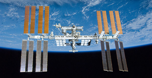
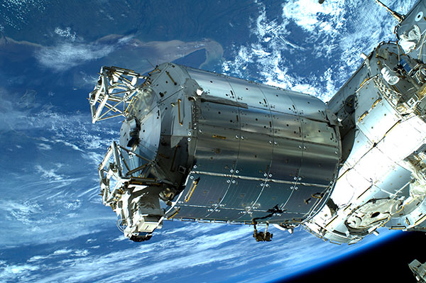
A new concept that involves mounting an instrument on the International Space Station and taking advantage of signals from navigation satellites could provide measurements of sea-surface height and information about features related to ocean currents, benefiting science and ocean forecasting.
We have all seen the beautiful photographs of our planet taken by astronauts, but orbiting Earth 16 times a day just 400 km above, the Space Station also offers a platform from which to measure certain variables related to climate change.
So, in 2011 the European Space Agency (ESA) called for proposals to explore how the Space Station could be used to make scientifically valid observations of Earth. After reviewing and assessing numerous proposals, the result is to further develop the GEROS-ISS mission concept.
Jason Hatton, GEROS-ISS project coordinator, said, “The concept is still going through feasibility studies, but the aim is to launch the experiment towards the end of 2019. It would be carried to the Space Station on a cargo vehicle and installed on ESA’s Columbus space laboratory using a robotic arm, after which GEROS-ISS would run for at least a year.”
GEROS-ISS stands for GNSS reflectometry, radio occultation and scatterometry on board the ISS. GPS and Galileo satellites send a continual stream of microwave signals to Earth for navigation purposes, but these signals also bounce off the surface and back into space.
The idea is to install an instrument with an antenna on the Space Station that would capture signals directly from these satellites as well as signals that are reflected or scattered from Earth. This process could be used to calculate the height of the sea surface, and to measure waves — or “roughness” — that can then be used to work out the speed of surface winds.
Variations in sea-surface height (cm) obtained by merging multiple altimeter measurements. GEROS-ISS would be able to observe this variability so that maps covering latitudes 51° N to 51° S can be produced every four days. (Photo: ESA)
GEROS-ISS is primarily an experiment to demonstrate new ways of observing Earth. However, if taken beyond the testing phase this new approach would complement measurements from satellites carrying altimeters such as CryoSat and Sentinel-3, and satellites carrying wind scatterometers such as MetOp.
Importantly, it is the first concept to assess the potential of spaceborne GNSS reflectometry to determine and map ocean height at scales of 10–100 km or longer in less than four days. Current satellite altimeters, in comparison, offer global maps at scales of around 80 km, which are produced from multiple datasets every 10 days.
A system based on GEROS-ISS would, therefore, complement existing satellite systems, helping to map ocean variability at finer spatial and temporal scales over a range of seas in tropical and temperate regions. It would also refine our understanding of how well the concept would work for measuring the roughness of the ocean surface.
In this respect, the development of GEROS-ISS benefits from experience gained with the UK’s TechDemoSat-1, which also measures ocean-surface roughness using a similar technique. It is also hoped that NASA’s upcoming CYGNSS constellation of mini satellites will help pave the way for GEROS-ISS.
In addition, GEROS-ISS uses a technique called radio occultation whereby the antenna receives signals that are refracted as they pass through the atmosphere. This can be used to generate vertical profiles of atmospheric humidity, pressure and temperature, as does the GRAS instrument on the MetOp satellites, for example.
GEROS-ISS will be installed on the upper balcony of ESA’s Columbus space laboratory, which provides mechanical interface plates as well as power, command and data links to the ISS systems. (Photo: ESA, taken by ESA astronaut Luca Parmitano during his spacewalk on July 9, 2013. )
“It is very flexible, combining different mission concepts and applications in one: GNSS-reflectometry to determine sea-surface height, scatterometry to measure sea-surface roughness and radio occultation for atmospheric studies,” said Jens Wickert who leads the science team that proposed GEROS-ISS.
ESA engineer Manuel Martin-Neira noted, “The original concept actually goes back over 20 years and has matured considerably through numerous studies and campaigns, however, it has never been duly tested from space.”
“Being able to use the International Space Station in this way means that we can quickly validate innovative observing techniques without having to build an entire satellite, and we expect this to lead to new opportunities for science,” added Michael Kern, ESA’s GEROS-ISS mission scientist.
The GEROS-ISS feasibility studies are being carried out through ESA’s General Studies Programme.
Editor’s Note:GPS World discussed the use of GPS for radio occultation in itsMarch 1994 Innovation column, “Monitoring the Earth’s Atmosphere with GPS,” by Rob Kursinski.
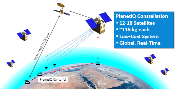
The company PlanetiQ plans to use GNSS to make real-time weather forecasts. PlanetiQ plans to launch a commercial weather satellite constellation by 2017, composed of 12 to 18 small satellites that will capture data as GNSS satellites pass through Earth’s orbital horizon.
The satellites will use radio occultation to collect data that will supplement computer models on weather, producing more accurate and timely weather forecasts and assessments, PlanetiQ said. The satellites will measure how GPS, GLONASS, and BeiDou radio waves bend as they travel through the atmosphere, a technique that provides snapshots of temperature, pressure and water vapor, as well as insight into whether solar storms are active in the ionosphere, reports Discovery News.
Figure credit: PlanetiQ.
More than 30,000 occultation measurements can be collected each day.
PlanetiQ is one of five companies in the United States looking to commercialize weather forecasting. GeoOptics is working on a similar system and plans to launch its first satellite this year.
Explore further:
PlanetiQ President and CEO Anne Hale Miglarese discussed the project on The Weather Channel in August 2014.
Attila Komjathy, a NASA Jet Propulsion Laboratory principal investigator and adjunct professor in the University of New Brunswick’s Department of Geodesy and Geomatics Engineering, was named a Fellow of the Institute of Navigation in January for his work on remote sensing of the Earth’s ionosphere using signals from GNSS.