New solution eliminates positioning errors in logistics, rail, and public safety by providing lane-level accuracy natively on rugged mobile devices.
Swift Navigation, a global leader in precise positioning technology, and RugGear, a manufacturer of rugged mobile devices for professional use, have joined to embed high-accuracy positioning capabilities into RugGear’s enterprise and mission-critical mobile devices.
The partnership integrates Swift Navigation’s Skylark Precise Positioning Service directly into RugGear devices built on the Qualcomm Snapdragon 6 Gen Platform. This native integration delivers reliable lane-level accuracy — an order of magnitude improvement over standard GPS — without requiring any external receiver or configuration. Precise positioning is available out of the box, ensuring seamless performance across rugged mobile form factors.
This integration is a major step in bringing high-accuracy positioning to industrial mobility. All location-based applications benefit automatically, meaning developers do not need to modify their existing apps.
Enhanced Capabilities with the RG940
The first device to integrate Skylark will be the RG940, a high-performance, rugged 10.1-inch tablet designed for demanding industrial uses. The high accuracy improves operational efficiency and accountability across enterprise segments, including:
Logistics and Waste Management. Optimizes routes, reduces fuel costs, and provides indisputable proof of service records for liability claims.
Construction. Provides a value-engineered approach for GIS mapping assets and enhances worker safety through geofenced “no-go” zones.
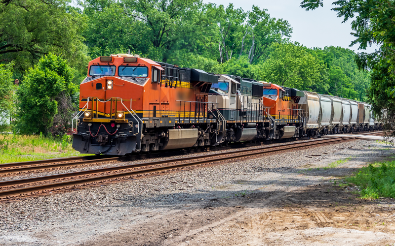
Rail. Enhances safety and efficiency for trains and prevents freight car loading errors.
Interested customers and partners are invited to contact RugGear directly for availability and technical specifications.
Intecs, a hardware and software developer, is creating a multi-sensor, GNSS-based platform for obtaining absolute position of trains on rail lines. The system incorporates cameras that read QR codes installed in the area adjacent to the track. The system includes a robust, software-based, data fusion engine that combines GNSS and visual data to determine train position.
The delay when a train loses its position can be significant and affect other vehicles on the rail lines. The Intecs system — assisted GNSS with imaging sensors for rail applications (AGIS4RAIL) — can correctly identify the position of a vehicle.
Test campaign
Numerous field tests have been conducted for the new system. One of the most critical sets of trials was carried out on an auto racing track. The trial involved a ground vehicle with GNSS antennas positioned on the roof and with cameras pointing to the side where QR code panels were set up at 10 m intervals. The vehicle was driven for 30 laps around the course under various conditions. AGIS4RAIL correctly identified the position of the vehicle at every lap, with the vehicle achieving a maximum speed of 35 km/h. The maximum estimated error was 4.76 m, which is in line with the target of 5 m.
Imaging sensors help to reduce the negative impact of various local effects on positioning systems that rely solely on Global Navigation Satellite Systems (GNSS), such as multipath errors. The AGIS4RAIL system also offers protection against jamming and spoofing. Additionally, the QR-code landmarks can contain data to verify the authenticity of the landmark itself.
Further testing continues and will soon include trials onboard operational trains in Italy, according to Intecs. The AGIS4RAIL project received funding under the European Space Agency’s Navigation Innovation and Support Program (NAVISP).
Trimble has released Trimble 4D Control (T4D) version 6.4 software and an add-on monitoring module for automated and semi-automated rail monitoring. The T4D Rail module enables simple data collection and reduces office work required to automate movement detection for rail monitoring projects.
The T4D software offers four main elements for automated monitoring: sensor management and data integration for GNSS, total station, geotechnical, vibration and environmental sensors; geodetic processing and adjustments for accurate results; analysis and visualization through several tools that provide real-time updates to support in-depth analysis and data presentation; and alarming and reporting.
The T4D Rail module enables integration of rail as-builts collected with the Trimble GEDO system or with a track measuring bar paired with the Trimble Access Gauge Survey app. It can also automate calculations for track geometry parameters, generate analysis charts, and trigger alarms.
The T4D software is offered in five editions to fit various project requirements. The editions include T4D Access, T4D Field, T4D Intermediate, T4D Geotechnical and T4D Advanced. T4D Access and T4D Advanced are the two editions that support the add-on Rail Module.
The commuter rail industry is making progress installing and implementing positive train control (PTC), according to an analysis by the American Public Transportation Association (APTA), an advocate for the advancement of public transportation programs and initiatives in the United States.
The advancements reflect the commuter rail industry’s commitment to safety and implementing PTC by the Dec. 31 statutory deadline, APTA said in a statement.
PTC is a complex signaling and communications technology that commuter rail agencies are installing to offer a critical safety overlay on top of an already safe industry. In fact, rail is the safest surface transportation mode and traveling by commuter rail or intercity rail is 18 times safer than traveling by automobile.
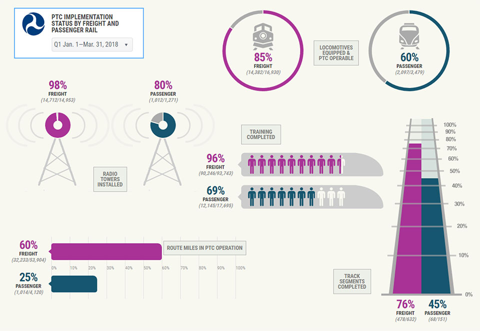
The Federal Railroad Administration issued a PTC progress report in July, with the infographic below.
Chart: Federal Railroad Administration, Jan-March 2018
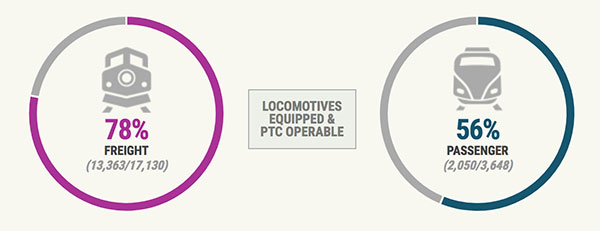
This is in contrast to a previous PTC infographic, released in June 2016.
Chart: Federal Railroad Administration, June 2016
According to APTA, as of June 30, 2018:
91 percent of spectrum has been acquired;
85 percent of 13,698 pieces of onboard equipment have been installed on locomotives and cab cars etc.;
79 percent of 14,083 wayside (on track equipment) installations have been completed;
78 percent of back office control systems are ready for operation;
74 percent of 14,847 employees have been trained in PTC; and
34 percent of commuter railroads are in testing, revenue service demonstration, or are operating their trains with PTC.
“Every year, 30 commuter railroads across America safely carry passengers on 501 million trips,” said APTA President and CEO Paul P. Skoutelas. “With safety as our number one priority, the commuter railroads are making strong and continuous progress in implementing Positive Train Control.”
Under current law (49 U.S.C. 20157), commuter railroads are required to meet the following milestones by Dec. 31. As defined in 49 U.S.C. 20157(a)(3)(B), they are to have:
Installed all PTC hardware (wayside and onboard equipment);
Acquired all necessary spectrum for PTC implementation;
Completed all employee training;
Initiated testing on at least one territory subject to the PTC requirement (or other criteria); and
Submitted a plan and schedule to the Secretary of Transportation for implementing a PTC system.
Upon reaching these milestones by the end of 2018, the commuter railroads must implement PTC as soon as practicable and no later than December 31, 2020.
“Positive Train Control is a critical commuter rail safety enhancement,” said SEPTA General Manager Jeffrey D. Knueppel, general manager of the Southeastern Pennsylvania Transportation Authority (SEPTA). “Implementing PTC at SEPTA, during a challenging period of capital funding, has been an authority-wide commitment. Throughout this effort, our in-house team has been working continuously with Amtrak, our freight partners, and third-party contractors to address technical and interoperability challenges. SEPTA trains on all 13 regional rail lines are equipped and operating with PTC, and SEPTA is proud to have implemented this safety technology for our customers and employees.”
“Implementing Positive Train Control in Chicago’s dense and busy railroad network has been very challenging, but Metra is right where we said we’d be in terms of finishing the job,” said Jim Derwinski, CEO/executive director of Metra, the Northeast Illinois commuter rail system. “Working with our freight partners, we expect to have PTC implemented or in revenue service demonstration on six of our 11 lines by the end of 2018, and to complete the job by 2020.”
The commuter rail industry is moving aggressively to implement PTC as it faces considerable technical and financial constraints. At a time when the national transit state of good repair backlog stands at an estimated $90 billion, the commuter railroad industry’s cost to implement PTC will exceed $4.1 billion, diverting funds from other critical infrastructure priorities.
Since Congress mandated PTC, the federal government has awarded $272 million in PTC grants. Another $250 million was made available in May 2018.
PTC is an unparalleled technical challenge in scale, complexity, and time required. The challenges include:
a limited number of PTC-qualified vendors simultaneously in demand by both the passenger and freight railroad industries to develop, design and test this complex safety technology;
diagnosing and resolving software issues,
securing adequate access to track and locomotives for installation and testing, and
achieving interoperability, as commuter rail systems operate in mixed traffic with other freight and passenger railroads.
The U.S. Federal Railroad Administration (FRA) released a status update on its efforts to assist railroads in implementing positive train control systems (PTC), along with the railroads’ self-reported progress for the fourth quarter of 2017.
The FRA said in a press release that it is taking a proactive approach to ensure railroads acquire, install, test and fully implement certified PTC systems in time to meet the congressional interim deadline of Dec. 31.
“It is the railroads’ responsibility to meet the congressionally mandated PTC requirements,” said FRA Administrator Ronald L. Batory. “The FRA is committed to doing its part to ensure railroads and suppliers are working together to implement PTC systems.”
Between Jan. 2 and Feb. 14, FRA’s leadership hosted face-to-face meetings with executives from each of the 41 railroads subject to the statutory mandate to evaluate each railroad’s PTC status and learn what remaining steps each needs to take to have a PTC system fully implemented by the December deadline or, at a minimum, to meet the statutory criteria necessary to qualify for an alternative schedule.
The FRA is now meeting with PTC suppliers to learn more about their capacity to meet the high demands for railroads’ implementation of PTC systems in a timely manner.
PTC systems are designed to prevent certain train-to-train collisions, over-speed derailments, incursions into established work zone limits, and trains going to the wrong tracks because a switch was left in the wrong position.
All railroads subject to the statutory PTC implementation mandate must implement FRA-certified and interoperable PTC systems by the end of the year.
Under the Positive Train Control Enforcement and Implementation Act of 2015, however, Congress permits a railroad to request FRA’s approval of an “alternate schedule” with a deadline beyond Dec. 31, 2018, but no later than Dec. 31, 2020, for certain non-hardware, operational aspects of PTC system implementation.
The congressional mandate requires the FRA to approve a railroad’s alternative schedule with a deadline no later than Dec. 31, 2020, if a railroad submits a written request to FRA that demonstrates the railroad has met the statutory criteria set forth under 49 U.S.C. § 20157(a)(3)(B).
The fourth quarter data, current as of Dec. 31, 2017, shows PTC systems are in operation on approximately 56 percent of freight railroads’ route miles that are required to be governed by PTC systems — up from 45 percent last quarter and 16 percent on Dec. 31, 2016. Passenger railroads have made less progress, with PTC systems in operation on only 24% of required route miles, unchanged from the previous quarter.
The latest data confirms that railroads continue to make progress in installing PTC system hardware, with 15 railroads reporting they have completed installation of all hardware necessary for PTC system implementation and another 11 railroads reporting they have installed over 80% of PTC system hardware. In addition, all but three railroads report having acquired sufficient spectrum for their PTC system needs.
For more key implementation data for the fourth quarter, see the infographics here.
To view the public version of each railroad’s Quarterly PTC Progress Report (Form FRA F 6180.165, OMB Control No. 2130-0553) for Quarter 4 of 2017, visit each railroad’s PTC docket on https://www.regulations.gov/. Railroads’ PTC docket numbers are available at https://www.fra.dot.gov/Page/P0628.
While not as glamorous as mild-mannered Clark Kent holding down a day job while Superman comes to the rescue in time of crisis, there are professional surveyors who work day jobs to perform our duties as practitioners to make a living and participate in association activities in their off-hours to help promote and protect their profession as well as the public they serve.
Many of the hours spent to protect the profession are in the political arena, where the battle for budget dollars and service rights are fought on nearly a daily basis. Because of the reliance of the surveyor on technological advances, the profession has been thrust into the political arena at all legislative levels. The surveyor has been tasked with leading the discussion and help the public understand why significant dollars are needed for funding many different programs to continue with our high-tech trends and lifestyles.
Three of the four presidents on Mount Rushmore started as surveyors — George Washington, Thomas Jefferson and Abraham Lincoln. (Photo: National Park Service)
The role of the surveyor has not been considered political even though several significant U.S. presidents were surveyors in their early careers. Surveyors aren’t particularly known for their public personas, much less their political prowess. Other than states that still have county surveyors, rarely do practitioners stray beyond local municipal government. One is more likely to see a professional engineer or architect as an elected official than a surveyor, but that doesn’t mean the issues we face are any less important.
My current position is a professional land surveyor with a full-time job overseeing a department in a multi-discipline office in a major metropolitan area. Besides being a contributing editor to GPS World through these articles, I also voluntarily wear many hats within our state association and the national surveying society. Several of these hats are government affairs positions at both state and federal levels, as it has become a full-time operation to keep a watchful eye at all governmental levels. From changes in regulations, budgetary revisions and threats to our professionl by outside entities, government affairs take a small army of people to keep abreast of all situations.
This month’s submission is just a snapshot of the current National Society of Professional Surveyors (NSPS) Joint Government Affairs Committee action item list being addressed and monitored through its committee members and a governmental lobbyist. The importance of this list is to give the reader a sampling of the seemingly endless battles being waged on Capitol Hill by NSPS and its members nationwide.
All these issues have GNSS at their heart and will have dire consequences if any of these subjects fall short of their intended marks.
This is not just about the GNSS and how we collect data; it’s also about the necessity of large scale data collection to provide better and safer services to the citizens of the United States and its territories.
Our current datasets and standards for data collection, like our infrastructure, is aging and lacking in detail. Serious upgrades are overdue, so several actions have been put forth to try to rectify the shortcomings.
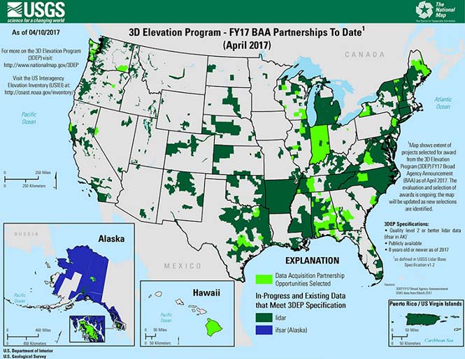
3DEP
Formally known as the 3D Elevation Program, this language was introduced as part of S. 1460 (“Energy and Natural Resources Act of 2017”) by Senator Lisa Murkowski of Alaska. This program is being created so that consistent elevation data, cultivated through many surveying and mapping sources including lidar, will be available for efficient design use throughout the American infrastructure.
While it currently does not have a single line item in any budget, the USGS Budget Summary lists its necessity in the Core Science Systems Program as part of the National Geospatial Program. This program is intended to provide high-quality topographic, geologic and hydrographic data nationwide to assist with further development of energy, transportation, drainage, emergency response and hazard mitigation.
As part of the 2019 President’s Budget, the USGS Green Book also lists having the entire nation covered by an ongoing lidar program by 2033, along with completing a significant amount of data collection by various means in Alaska by 2022, including high-resolution interferometric synthetic aperture radar (IfSAR) necessary for data collection in more difficult terrain.
The Green Book also lists high-resolution hydrographic data to support flood risk management studies, as the frequency of large scale flooding seems to be increasing substantially in more places than ever before. It also includes additional mapping data, programming and functionality for emergency personnel charged with oversight of public safety in times of crisis.
FAA reauthorization
The current FAA authorization bill expires on March 31. The biggest hang up holding up getting the bill reauthorized is privatization of the air traffic controllers, but there are rumors of tightening of UAV rules due to the rapidly growing use of the vehicles for business and personal use.
Surveyors are working with federal and state officials to help implement reasonable rules for use and coverage of the UAV as the field of surveying has been drastically affected by use of aerial vehicles. Many tasks that used to take days now take hours with increase accuracy, so the effects of the UAV will be seen for many years to come.
Digital Coast Act
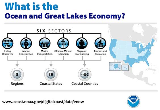
One of the legislative acts that NSPS was a big part of in 2017 was Senate Bill 110, “The Digital Coast Act” which led to the introduction of the companion bill in the House as H.R. 4062. This Act will allow NOAA to perform the necessary actions to actively and effectively monitor all coasts (including the Great Lakes) by various means, including bathymetric and conventional survey methods. This will require services to be performed by public and private surveyors primarily with GNSS capability to provide NOAA with standardized information based upon established datum.
FLAIR Act
The Federal Land Asset Inventory Reform (FLAIR) Act of 2017 was introduced as House Resolution 2199 to help with creating a database of government property nationwide. The Government Accountability Office (GAO) has stated that the management of federal real property has become a “high-risk” item on its list of duties. Management of the number and value of properties has increased to a point that an overall dollar amount of federal buildings and land cannot be accurately determined.
How does the surveyor fit in with this issue? Simple. The U.S. government will need to upgrade its database of existing facilities through having them surveyed for asset management. Part of the requirements for providing these surveys will be completing the work in datums that will be following the geographical databases being designed to contain the parcel and building information. All this data will have geospatial information regarding parcel, address, utilities and functionality of the inventory, so providing the data with the sufficient attributes will become a key role for the surveyor. GNSS data collection will be at the heart of this monumental task.
Geospatial Data Act
As introduced in May 2017, the Geospatial Data Act (GDA) of 2017 is intended to jumpstart the nationwide initiative to develop and coordinate efforts to collect and maintain new datasets of elevation and infrastructure information. It is intended to improve and enhance federal geospatial activities to encourage state and local agencies to participate at the local level.
It is interesting to note, however, that the revised Geospatial Data Act was introduced by the same sponsors that did not include procurement procedures that follow the typical Brooks Act of quality-based selection, and instead relied on bid-based selection commonly found with suppliers. Both bills are being vetted by their sponsors and potential geospatial providers for clarity with ongoing debate going forward.
Hydrographic Services Improvement Act
H.R. 211 bring us the Hydrographic Services Improvement Act to provide NOAA with incentive and funding to standardize surveys desperately needed in waterway areas. Ongoing discussion continues this spring to determine sources of funding and priority of projects.
Infrastructure bill
February brought us the introduction of a significant infrastructure program aimed at improving roads, airports and bridges, with other major improvements across the country. This program is noteworthy in recognizing the need of current geospatial data and inventory of major infrastructure needs. The program sets forth the need for surveying, mapping and geospatial data for planning, design, construction, operations and maintenance for a multitude of projects nationwide. Much more will be discussed regarding the funding and priority of projects as the political year moves on.
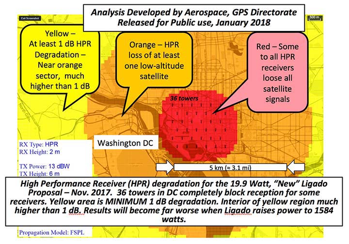
LightSquared/Ligado
Readers may remember when the original confrontation with LightSquared began in 2011, and the subsequent battle over the frequency ranges adjacent to the GPS bandwidth. The FCC gave LightSquared initial but conditional approval to move forward with terrestrial-based transmission for 4G cellular transmission for up to 40,000 land-based stations. Testing by private and governmental agencies through 2011 and 2012 proved that LightSquared would greatly harm GPS activity for both public and private use. Once exposed, the conditional FCC approval was rescinded and LightSquared retreated into the shadows…until now.
Reformed as Ligado, it has fresh investors and is making a charge into 5G technology with a revised game plan. While it is also looking to use other spectrums for communication, it once again is dangerously close to other current uses. Couple the proximity of adjacent bandwidth with the intense land-based signal versus a very weak satellite signal, there will be significant overriding by the new user. All of this is still being worked out through the FCC and the Department of Defense, so final resolution is yet to be seen.
IMAGES Act
The National Flood Insurance Program (NFIP), as part of FEMA, is looking to move forward with legislation introduced as Improvement of Mapping, Addresses, Geography, Elevations and Structures (IMAGES) Act (H.R 4905). This act intends to reform the NFIP program by utilizing new elevation data collected through the 3DEP program, which will be combined with other parcel attributes including addresses and structure types. This data will then be combined with refined floodway information to identify parcels that are more susceptible to damage caused by storms and flooding.
New legislation can be a good thing, but only if funding can be provided. This bill could provide a major upgrade to the flood mapping and insurance program, but it will hit a big snag with lack of monetary support. The proposed funding for FY2019 is $100 million, yet the project costs for the FY2018 budget is $178 million. This significant difference will make a large impact on the effectiveness of the program and proposed revamp.
Railroad reauthorization
NSPS has spent several years working with various legislators trying to find the right bill to insert language to require railroads to monument their routes before removing tracks. But with the recent accidents of various rail lines, the spotlight has been put on various factors that cause the incidents and how to eliminate their occurrence.
Positive train control (PTC) systems incorporate geospatial data collected through GNSS, lidar and conventional surveying means to work with operational systems to assess dangerous situations. Surveyors will need to be at the forefront of the necessary data collection so our efforts to continue lobbying for railroad funding will continue.
Net Neutrality Act
A political hot topic the surveyor doesn’t typically think about is net neutrality. Most people think they will be affected by lack of neutrality slowing down their home internet or streaming service, but for surveyors it will be a much bigger deal.
A remarkable number of surveyors and mappers use cellular data streaming to provide a connection to a positional correction service. The throttling of this data will effectively slow down the performance and quality of the positional data, leading to less reliability and productivity. It will also slow down the data interaction of office and field staff exchanging data and image files critical to project productivity and success.
So, when the call goes out to contact your federal representative to protect net neutrality, remember how it will affect your surveying business model and make that call.
How professional land surveying associations get it done
Many thanks to the countless hours put in by the NSPS Joint Government Affairs team, consisting of Committee Chair Pat Smith, NSPS Government Consultant John Palatiello, NSPS Federal Lobbyist John “JB” Byrd and NSPS Executive Director Curt Sumner. This group is constantly monitoring legislative action across the country as well as in D.C. and is quick to respond when action is needed on legislative issues. They do a tremendous job, yet not many see them in action. Hopefully all surveyors will continue to see and feel the benefits of their results.
As simple as the process is, the political world has gotten much more complicated as time marches on. From local municipal offices to Washington, D.C., getting things done through legislation has become a long process that takes patience and plenty of money to get your voice heard. Surveyors are no different than any other profession in that we must stay out in front of issues that affect our physical and business world. The important part is to stay informed and have a voice.
Let’s also remember those three fine individuals, memorialized on Mount Rushmore, who accomplished great things after their stints as surveyors, so anything is possible if we keep our voice in government.
Surveying has evolved into a highly technical professional with GNSS as a backbone method of data collection. With the U.S. government at the center of that technology, we need to make sure we, as the surveying practitioner, stays engaged.
Travelers taking Amtrak between New York City and Philadelphia are now being protected by a new crash-prevention system.
Amtrak, the United States’ national passenger railroad, has activated positive train control between New York City and Philadelphia, the last stretch of its tracks on the busy Northeast Corridor to get the system, reports the Wall Street Journal.
Amtrak activated the system between Philadelphia and Washington, D.C., earlier this month. It is meeting an original Dec. 31 federal year-end deadline. In October, Congress extended the deadline to December 2018.
If it had been operating, the safety system could have prevented an Amtrak derailment in Philadelphia in May that killed eight and injured more than 200 others.
Positive train control prevents train-to-train collisions, over-speed derailments, incursions into established work zone limits and a train going to the wrong track because a switch was left in the wrong position.