Tag: Reno

  • Iris Automation launches ground-based surveillance system for UAVs

    Iris Automation launches ground-based surveillance system for UAVs

    Photo: Iris Automation
    Photo: Iris Automation

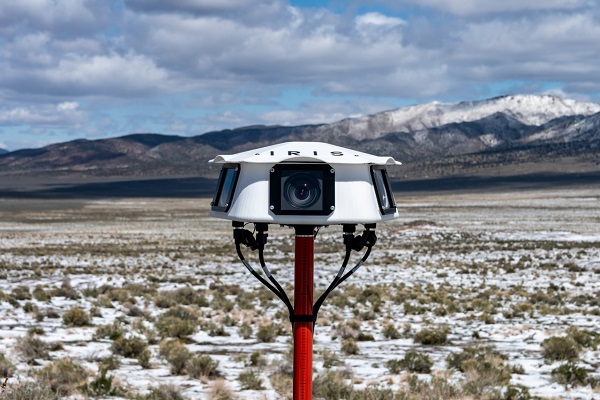
    Iris Automation has announced the commercial availability of Casia G, a ground-based version of its detect-and-avoid surveillance solution.

    Using the same patented artificial intelligence (AI) and computer-vision technology as Iris Automation’s onboard solutions, Casia G provides 360° optical detection with alerts. It enables operators to avoid both cooperative and non-cooperative aircraft for safe beyond-visual-line-of-sight (BVLOS) flight.

    Casia G creates a perimeter of monitored airspace for UAVs to perform work safely, without additional payload. It’s suitable for operations in fixed or temporary locations, supporting drone-in-the-box operations and augmenting or replacing human visual observers. BVLOS flight for unmanned systems has been challenging due to right of way concerns, specifically the inability for unmanned aircraft to successfully see and avoid other aircraft.

    “A human has sufficient visual acuity to see airborne traffic only within a +/-5 degree field of view around our focal point. We have to scan the sky, and are frankly not very good at it,” said Jon Damush, CEO, Iris Automation. “Casia G sees the entire sky, with uniform probability and resolution, 10 times per second — without distractions or breaks. This  solution for airspace awareness covers a large majority of small UAS use cases, but at a price point that is economically viable and without complex integration.”

    Casia G can be expanded by adding additional units in a mesh to create a network of detection nodes for large-area air risk mitigation. The system then provides a single feed of cooperative and non-cooperative air traffic, available to an operator’s traffic management system. This provides a path to approvals for both larger area and one-to-many operations by enabling a holistic view of the airspace, the company said.

    Casia G has already obtained a BVLOS waiver on behalf of the City of Reno. Iris Automation is in the process of proving additional deployment patterns and concepts of operation with the FAA.

  • Research Roundup: GPS reveals volcanic activity under Europe

    Research Roundup: GPS reveals volcanic activity under Europe

    Scientists have discovered new evidence for active volcanism next door to some of the most densely populated areas of Europe. The study crowdsourced GPS monitoring data from antennae across western Europe to track subtle movements in the Earth’s surface, thought to be caused by a rising subsurface mantle plume.

    The Eifel region lies roughly between the cities of Aachen, Trier and Koblenz, in west-central Germany. It is home to many ancient volcanic features, including the circular lakes known as maars. Maars are the remnants of violent volcanic eruptions, such as the one that created Laacher See, the largest lake in the area. The explosion that created the lake is thought to have occurred around 13,000 years ago.

    The mantle plume that fed this ancient activity is thought to still be present, extending up to 400 kilometers (km) into the earth. However, whether or not it is still active is unknown. “Most scientists had assumed that volcanic activity in the Eifel was a thing of the past,” said Corné Kreemer, lead author of the new study. “But connecting the dots, it seems clear that something is brewing underneath the heart of northwest Europe.”

    An aerial view of Laacher See, a volcanic caldera lake with a diameter of 2 km in Rhineland-Palatinate, Germany. Created by volcanic activity, maars like this are also found in other parts of Europe and on other continents, but Eifel-Maars are the classic example worldwide. (Photo: bbsferrari/iStock / Getty Images Plus/Getty Images)
    An aerial view of Laacher See, a volcanic caldera lake with a diameter of 2 km in Rhineland-Palatinate, Germany. Created by volcanic activity, maars like this are also found in other parts of Europe and on other continents, but Eifel-Maars are the classic example worldwide. (Photo: bbsferrari/iStock / Getty Images Plus/Getty Images)

    In the new study, the team — based at the University of Nevada, Reno and the University of California, Los Angeles — used data from thousands of commercial and state-owned GPS stations all over western Europe. The research revealed that the region’s land surface is moving upward and outward over a large area centered on the Eifel, and including Luxembourg, eastern Belgium and the southernmost province of the Netherlands, Limburg.

    “The Eifel area is the only region in the study where the ground motion appeared significantly greater than expected,” said Kreemer. “The results indicate that a rising plume could explain the observed patterns and rate of ground movement.”

    The new results complement those of a previous study in Geophysical Journal International that found seismic evidence of magma moving underneath the Laacher See. Both studies point towards the Eifel being an active volcanic system.

    The implication of this study is that there may not only be an increased volcanic risk, but also a long-term seismic risk in this part of Europe. The researchers urge caution, however. “This does not mean that an explosion or earthquake is imminent, or even possible again in this area. We and other scientists plan to continue monitoring the area using a variety of geophysical and geochemical techniques, to better understand and quantify any potential risks.”

    GPS observations of ground movement under the Eifel area. Colors represent contoured vertical motion inferred from GPS station data, and white and black arrows indicate the direction in which the crust is horizontally stretching or compressing, respectively. The highest upward motion of ~1 mm per year is found near the Eifel volcanic field. (Image: Study authors)
    GPS observations of ground movement under the Eifel area. Colors represent contoured vertical motion inferred from GPS station data, and white and black arrows indicate the direction in which the crust is horizontally stretching or compressing, respectively. The highest upward motion of ~1 mm per year is found near the Eifel volcanic field. (Image: Study authors)

    Citation: “Geodetic evidence for a buoyant mantle plume beneath the Eifel volcanic area, NW Europe” by Corné Kreemer, Geoffrey Blewitt, Paul M. Davis. Geophysical Journal International, Volume 222, Issue 2, Aug. 1, 2020, pp. 1316–1332, https://doi.org/10.1093/gji/ggaa227