Russian satellites have caused GPS outages of as long as 10 seconds across Europe, according to a new research paper, authored in part by GNSS expert Todd Humphreys.
Humphreys is head of the Radionavigation Laboratory at the University of Texas at Austin. Separate research by Richard Bowden at Spanish company GMV supports the findings, according to The New York Times.
In at least three of 75 instances identified since 2019, the interference originated from as many as three Russian satellites. The other cases implicate the same Russian early-warning network; though data is insufficient to pinpoint the source, the same type of signal was identified.
Whether Russia knows of the interference — and its motives — is unknown, but the signals disrupt GPS, Galileo and BeiDou, and not Russia’s own GLONASS. The press office for the Russian Embassy in Washington, D.C. told The Times it had no comment.
The paper, “Chasing Lightning: Detecting, Characterizing, and Identifying a Powerful Space-Based GNSS Interference Source” by Zachary L. Clements, Argyris Kriezis and Todd E. Humphreys, can be accessed here.
The paper provides a comprehensive analysis of the GNSS interference phenomenon: wide-area transient interference from a space-based source causing up to 10-dB GNSS degradation across Europe since 2019 in the L1 band. The interference’s spatial, temporal and spectral properties are detailed. The researchers designed a framework to detect events using 1-Hz carrier-to-noise ratio observables from a network of 165 reference stations.
The three satellites implicated in the interference are part of Russia’s Edinaya Kosmicheskaya Sistema (EKS) constellation, which detects missile launches and nuclear explosions around the world. The first instance of this widespread jamming was recorded in October 2019, a month after the first EKS satellite was launched.
These cases are among the first known examples of GPS interference originating from space. Two historic cases of satellite interference were caused by technical glitches.
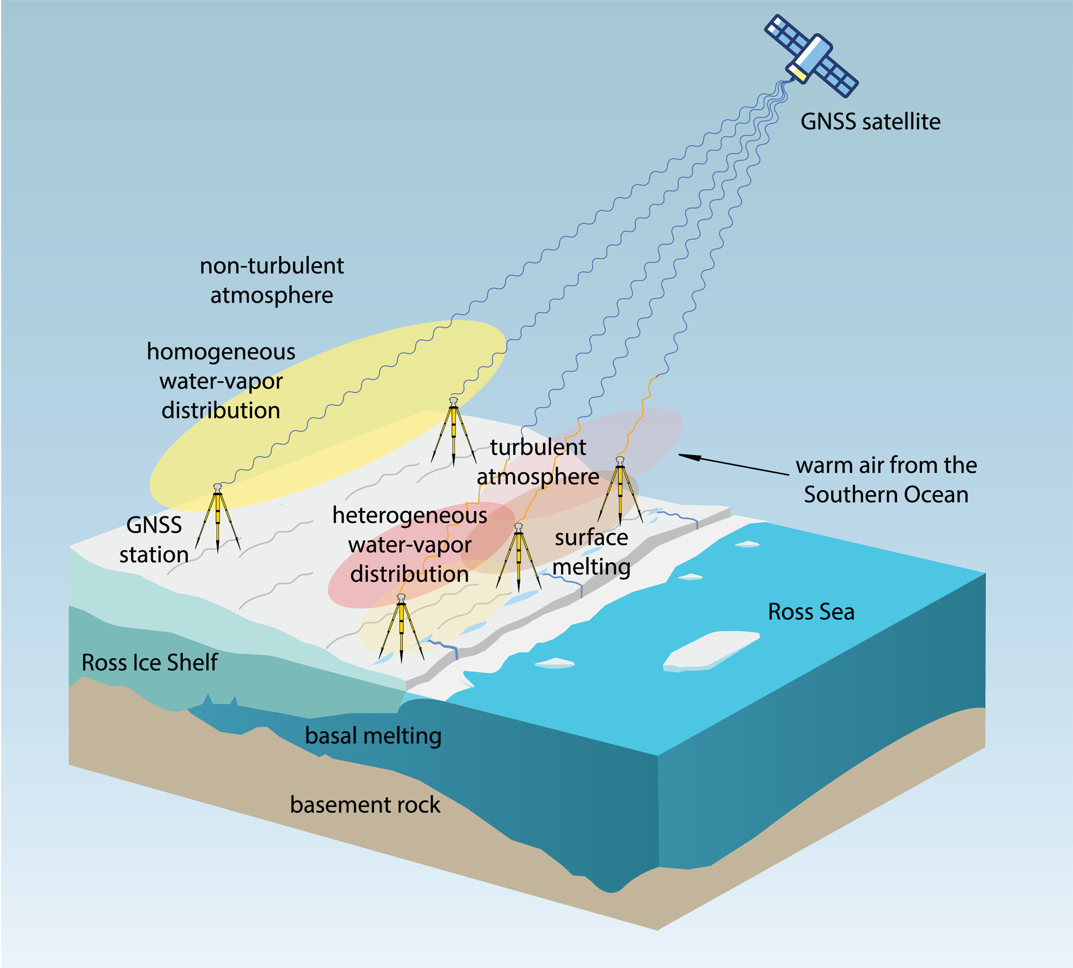
Observations suggest a major melting event at the Ross Ice Shelf was connected to atmospheric turbulence.
The Ross Ice Shelf in Antarctica typically melts on its underside as warmer ocean water flows beneath. But in January 2016, an unusual melting episode occurred on its topside.
A team from the Massachusetts Institute of Technology (MIT) Haystack Observatory used data from existing GNSS stations, in conjunction with 13 stations installed on shelf, to examine the turbulent state of the atmosphere. Key were delay differences at each station and between stations that showed the strength (or rockiness) of atmospheric turbulence over the ice shelf.
Wind, water vapor, and temperature variations drawn in by warm and humid air caused the surface to melt, with turbulence four times greater than usual during the 2016 surface melting event.
The study also demonstrated a novel application of the GNSS station data to remotely observe unusual atmospheric conditions.
The open-access study was published Feb. 27 in Geophysical Research Letters.
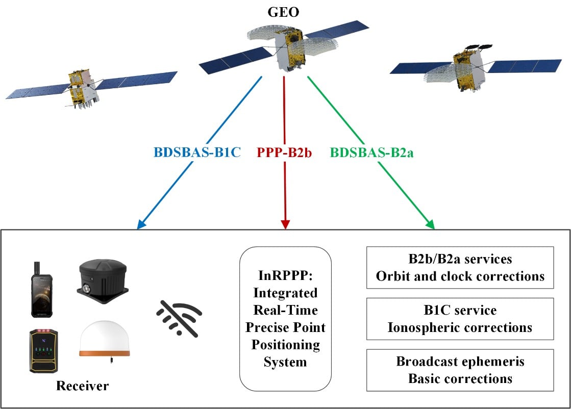
The development of an Integrated Real-Time Precise Point Positioning (InRPPP) system leveraging BeiDou Navigation Satellite System (BDS) B2b, B2a, and B1C services has significantly enhanced satellite-based positioning accuracy.
By resiliently utilizing these augmentation messages, the InRPPP system corrects satellite orbit and clock errors and mitigates ionospheric delays, outperforming traditional methods. Experimental results from both static and kinematic conditions demonstrate superior performance, showing improved positioning accuracy, faster convergence times, and greater stability in challenging environments. This breakthrough offers potential for applications in real-time navigation, precision positioning, and disaster monitoring, with a broader impact on industries requiring reliable and continuous positioning data.
The implications of the InRPPP system are vast, with applications spanning multiple sectors that depend on high-precision satellite navigation.
Satellite-based navigation systems, like the Real-Time Precise Point Positioning (RTPPP), are crucial for many industries that require accurate location data. However, these systems face limitations in areas with weak Internet connectivity or signal interference. BeiDou’s satellite augmentation services, namely B2b, B2a, and B1C, have emerged as a promising solution.
Yet, integrating these services into one cohesive system for optimal performance remained unexplored. This study pioneers the Integrated InRPPP system, which integrates all three services including correcting satellite clock, orbit errors, and ionospheric delays, unlocking new levels of positioning accuracy. The results from this research address critical limitations in current satellite-based positioning technology, setting the stage for real-world applications in complex environments.
In a 2025 Satellite Navigation publication (DOI: 10.1186/s43020-025-00172-x), researchers from the State Key Laboratory of Geo-Information Engineering and Key Laboratory of Surveying and Mapping Science and Geospatial Information Technology of MNR, State Key Laboratory of Spatial Datum, and Hohai University introduced the InRPPP system, a new approach that leverages the B2b, B2a, and B1C services of the BDS.
Scenes of the static experiment. The left and right panels denote the west and south sides of the station. (Photos: Study authors)
By combining these services, the InRPPP system corrects satellite orbit and clock errors while mitigating ionospheric delays. With enhanced accuracy, stability, and faster convergence times, this system has the potential to transform satellite-based positioning, offering more reliable and continuous service in real-time applications, especially in environments where traditional positioning systems struggle to perform.
The InRPPP system brings a new level of precision to satellite navigation by combining the best of BeiDou’s B2b, B2a, and B1C services. Through this integration, the system corrects satellite orbit and clock errors with B2b and B2a services, while B1C handles ionospheric delays. This resilient approach allows the system to deliver superior performance, even in high-occlusion or remote environments. The static experiments showed the InRPPP system surpasses other methods, with a 59.6% improvement in positioning accuracy and a 65.9% reduction in convergence time compared to using B2b, B2a, or B1C individually.
In dynamic conditions, the system demonstrated enhanced stability and reduced signal interruptions, achieving up to a 34.3% improvement in accuracy. The integration of these services increases the number of visible satellites, enhancing the Position Dilution of Precision (PDOP) values and ensuring better satellite geometry. This integrated approach not only improves accuracy but also ensures continuous, reliable solutions, making it a game-changer for fields like geodesy, navigation, and disaster monitoring.
Academician Yuanxi Yang of the Chinese Academy of Sciences, the lead researcher behind the InRPPP system, remarked, “The ability to integrate multiple BeiDou augmentation services into a single real-time positioning system represents a major breakthrough. By leveraging B2b, B2a, and B1C, our system offers a more reliable and accurate solution than anything available today. In both static and kinematic tests, the InRPPP system has outperformed traditional positioning methods, demonstrating its robustness and resilience in environments where signal conditions are far from ideal. This system is already applied in real applications and has potential to reshape industries reliant on satellite navigation and positioning.”
The implications of the InRPPP system are vast, with applications spanning multiple sectors that depend on high-precision satellite navigation. From autonomous vehicles and precision agriculture to disaster management and geospatial services, the enhanced accuracy and stability offered by InRPPP can support real-time decision-making in critical environments. This system also promises to improve the resilience of navigation systems in regions with poor satellite visibility or signal interference. As technology advances, the InRPPP system could pave the way for even more robust solutions, advancing global sustainability goals and improving disaster response capabilities by offering uninterrupted, reliable positioning data.
A five-year research and development program has been launched to enhance GNSS navigation for aviation, encompassing security, integrity and spoofing resilience.
CMC Electronics is partnerinng with École de Technologie Supérieure (ÉTS) in Quebec, Canada, to create the CMC Electronics Industrial Research Chair in Resilient GNSS Navigation. The five-year chair, valued at more than $6 million, unites CMC’s avionics expertise, led by John Studenny, internationally recognized GNSS navigation expert and standards contributor, with ÉTS’s renowned LASSENA laboratory under René Jr. Landry, an expert in aerospace navigation and cybersecurity.
The chair will tackle critical threats to GNSS navigation for aviation, including jamming and spoofing. CMC and ETS aim to develop spoofing-resilient GNSS receivers capable of real-time detection, mitigation and total recovery from spoofing attacks, setting a benchmark in aviation safety and integrity.
Research focus areas
The chair’s work spans several integrated areas that target key GNSS security challenges:
integration of spoofing detection algorithms
spoofing resilience grading and stress testing frameworks
recovery mechanisms and certification benchmarking
advanced integrity algorithms (ARAIM)
sensor fusion and authentication technologies for spoofing mitigation
end-to-end spoofing-resilient GNSS prototype
next-generation inertial sensors with built-in integrity
Together, these areas aim to produce operational, spoofing-resilient GNSS systems suitable for aviation environments.
Broader impact and strategic alignment
The chair will train more than 65 highly qualified personnel (HQPs) and promote equity, diversity and inclusion in engineering. It supports initiatives to increase women’s representation and aligns with ÉTS’s strategic research fields in aerospace, cybersecurity, sensors and intelligent autonomous systems.
CMC Electronics is co-leading the research program and industrial deployment, ensuring that the outcomes are fast-tracked toward secure, export-ready GNSS solutions. Safran Trusted 4D contributes specialized expertise, and Jaunt Air Mobility provides operational insights for flight testing and system integration.
During the geomagnetic storm that took place May 10–11, 2024, GPS users reported significant positioning errors and outages. In particular, farmers in the Central United States reported difficulty in getting a fix with their tractors and other farm equipment.
Also affected, to a lesser extent, was the Southwestern United States.
A new study has identified the cause of the GPS outages by analyzing the data from a 1‐Hz GPS receiver network. Standalone GPS position errors In precise point positioning (PPP) mode in the Central United States reached 70 meters on May 10. The errors were attributed to a steep wall in ionospheric plasma that rapidly moved southward.
In the soutwestern states, the GPS position errors were elevated 10 to 20 meters because of the enhanced plasma density.
Vertical protection level as provided by WAAS.
Then, on May 11, intense auroral activity caused rapid enhancements in the ionospheric plasma, leading to abrupt position errors of 10 meters. Network‐based position systems likely encountered even longer duration of position errors because these ionospheric disturbances are localized.
“These findings highlight the need for more accurate understanding of ionospheric plasma conditions, as well as software and hardware improvements, to reduce disruptions during space weather events,” report the authors of “Spatio‐Temporal Evolution of Mid‐Latitude GPS Scintillation and Position Errors During the May 2024 Solar Storm.” Authors are Waqar Younas, Yukitoshi Nishimura , Weixuan Liao , Josh L. Semeter, Sebastijan Mrak, Jade Morton and Keith M. Groves. The full report will appear in an upcoming issue of the Journal of Geophysical Research: Space Physics and is now available on ResearchGate.
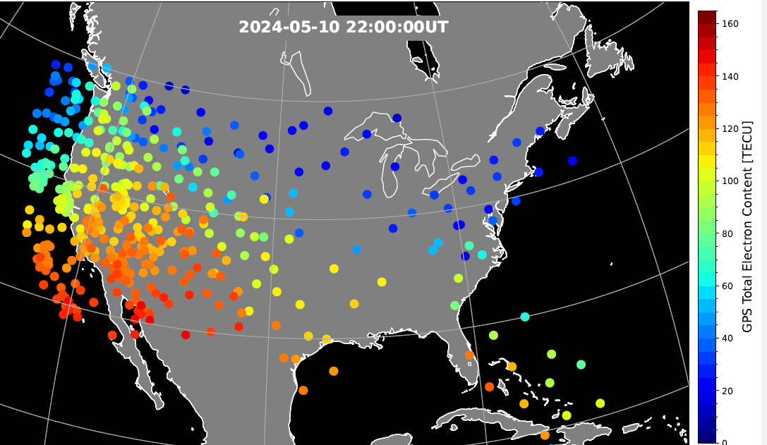
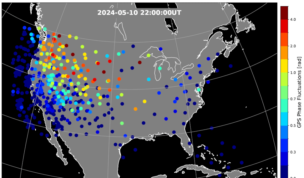
Figure 2. Phase scintillation index over the United States during the geomagnetic storm at 22:00 UT on May 10, 2024. The map is derived from the Global Positioning System (GPS) signals. The map shows enhanced phase fluctuations that impacted GPS position accuracy. Adapted from Figure 4d of the paper. (Credit: Authors)
Key Points
PPP failed to converge in the SED and trough, while PPK became unstable after CME arrival until the recovery phase.
SED, EIA, and trough created position errors on the noon‐evening sector. Substorms caused position errors on the nightside.
Scintillation, cycle slips, satellite geometry and ray bending were identified as contributing factors to the large position errors.
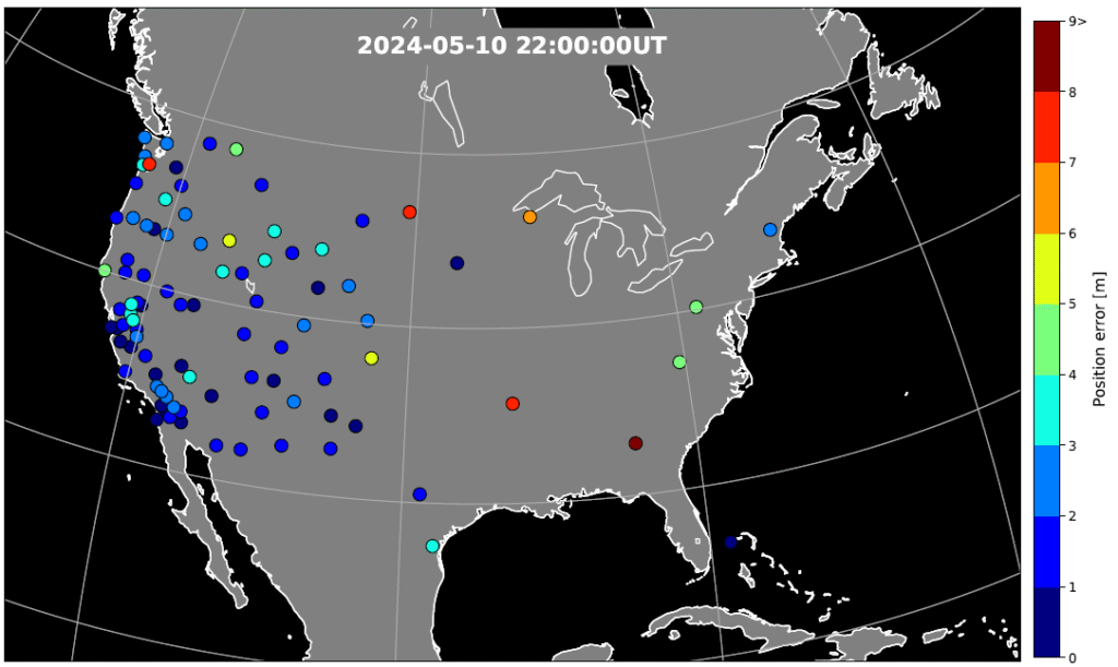
Figure 3. GPS position error over the United States during the geomagnetic storm at 22:00 UT on May 10, 2024. The map is derived from the Global Positioning System (GPS) signals. The map shows large error occurs at trough boundary and enhanced TEC regions. Adapted from Figure 5d of the paper. (Credit: Authors)
The study investigates impacts of the May 2024 superstorm on the mid‐latitude GPS scintillation and position errors. Using 1‐Hz GPS receiver data, the research team identified position errors in PPP mode reaching up to 70 m in the Central United States during the storm main phase on May 10.
The PPK solution becomes unstable following the arrival of storm and lasted till the recovery phase, coinciding with reported GPS outages of farming equipment. The large position errors were attributed to strong scintillation and carrier phase cycle slips around the equator-ward boundary of the ionosphere trough, where large total electron content (TEC) gradients and irregularities were present.
In the Southwestern United States, position errors of 10–20 m were associated with the storm‐enhanced density and equatorial ionization anomaly. Scintillation and cycle slips in this region were minor, and bending of the GPS signal paths (refractive effect) is the probable cause of the position errors. PPP outages were also associated with sudden changes in the geometric distributions of available GPS satellites used in position calculations.
On May 11, energetic particle precipitation during substorms led to abrupt jumps in TEC and scintillation, resulting in rapidly evolving position errors of up to 10 m. These findings highlight the critical role of storm‐time plasma transport, precipitation and irregularity formation in degrading GPS performance.
“The study underscores the need for accurate ionospheric state specification, improved signal processing technique, real‐time ionospheric corrections, and optimized satellite selection algorithms to enhance navigation resilience during severe space weather events,” the authors conclude.
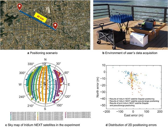
A novel method using signals of opportunity from low-Earth orbit (LEO) satellites is redefining what’s possible in satellite-based navigation. Researchers have developed a joint pseudo-range and Doppler positioning technique that taps into signals from constellations like Starlink and Iridium NEXT — without relying on traditional navigation signal structures.
By employing low-cost, wide-beam antennas and a specially designed time–frequency inversion algorithm, the team achieved remarkable accuracy: 3.6 meters in 2D and 6.2 meters in 3D, surpassing Starlink positioning approaches based on parabolic antennas by 35%.
Technical barriers in using signals of opportunity include signal transmission times, low signal power, and imprecise orbital data, all of which hinder accurate positioning. Addressing these challenges demands a new approach to extracting usable navigation data from LEO constellations.
In response, researchers from the Aerospace Information Research Institute introduced a joint pseudo-range and Doppler positioning method using wide-beam antennas to receive LEO satellite SOPs. The approach centers on a signal time–frequency inversion algorithm that reconstructs key signal parameters, alongside a novel accuracy metric called Equivalent Position Dilution of Precision (EPDOP).
Real-world experiments combining Starlink Doppler data and Iridium NEXT pseudo-range signals confirmed strong performance, especially in long-baseline conditions — reinforcing the method’s global applicability.
To overcome the cost and complexity of existing satellite tracking equipment, the team employed low-noise bock (LNB) wide-beam antennas capable of simultaneously receiving signals from multiple Starlink satellites. The core innovation lies in a signal processing algorithm that estimates transmission time and frequency from the received code phase and Doppler shifts — enabling both pseudo-range and Doppler observations without needing exact satellite clock data or real-time ephemeris.
To quantify system performance under real-world errors, the researchers developed the EPDOP metric, adapted to mixed measurement inputs. Tests demonstrated the method’s robustness: 3.6 m 2D and 6.2 m 3D positioning using Starlink Doppler signals, and up to 24 m (2D) and 41 m (3D) accuracy using Iridium NEXT SOPs over a 40 km baseline. Compared to Doppler positioning techniques, the algorithm reduced positioning errors by over one-third and successfully suppressed the impact of orbital inaccuracies inherent in public two-line element set (TLE) datasets.
“This work marks a key step toward accessible, accurate navigation using commercial satellite constellations,” said lead author Ying Xu. “By integrating Doppler and pseudo-range measurements and introducing a flexible precision metric, we can now harness Starlink and Iridium NEXT signals for high-precision positioning, even without access to proprietary signal structures. The proposed low-cost architecture opens new possibilities for resilient navigation in GPS-denied environments.”
Because of its ability to operate with low-cost antennas and weak, unstructured signals, the technique is poised to support a wide range of applications: from autonomous driving and unmanned aerial vehicle (UAV) navigation in remote regions to emergency response and IoT asset tracking. Its resilience to satellite orbital prediction errors and adaptability across different LEO constellations make it a strong contender for next-generation positioning systems. As LEO deployments continue to expand globally, this approach offers a scalable and practical solution for real-time, high-accuracy navigation—promising enhanced capabilities for both civilian infrastructure and defense operations.
TerraStar-C PRO is the first global correction service from Hexagon to incorporate RTK From the Sky technology to achieve RTK-level accuracy in three minutes with 99.999% availability
In late 2020, Hexagon’s Autonomy & Positioning division announced its technological breakthrough of global RTK From the Sky, demonstrating a future where instantaneous PPP and global RTK-level accuracy is possible.
Integrating this innovation into the core of TerraStar-C PRO, NovAtel’s corrections service, is the first phase in implementing RTK From the Sky technology into the company’s diverse portfolio of correction services for users worldwide.
As a result, TerraStar-C PRO has become the fastest global correction service to provide centimeter-level accuracy, not just in open-sky environments but also across challenging conditions created by buildings and foliage, according to Hexagon | NovAtel.
“RTK From the Sky technology is the foundation that enables our global correction services to be world-leading across agriculture, automotive, defense, survey, marine and autonomous applications,” said Michael Ritter, Autonomy & Positioning division president and CEO. “Our dedication to research culminated in an industry-changing technology; we’ll continue that commitment by providing the best positioning experience in speed, accuracy, availability and reliability anywhere in the world.”
TerraStar-C PRO now converges in less than three minutes by utilizing quad-band receiver and antenna technology to leverage modernized BeiDou III, GPS III and Galileo E6 signals. The resulting process generates state-of-the-art corrections for all GNSS frequencies.
Hexagon is a consistent innovator in GNSS, as seen in its role in developing RTK and PPP solutions. With this next-generation modernization of PPP correction generation and algorithm development, the company continues this tradition in providing the highest quality and best performing global positioning experience to users with land- and air-based applications.
“It’s been a privilege to collaborate across the division to develop RTK From the Sky technology and leverage our collective expertise in correction generation, PPP algorithms and the entire positioning ecosystem,” said Leos Mervart, head of PPP algorithm development at Hexagon’s Autonomy & Positioning division. “I’ve worked with PPP technologies since the beginning of my career and am proud to say that this is a new era of what global positioning can look like.”
The TerraStar-C PRO improvements are accessible now through the 7.08.10 firmware release for users on OEM7700, OEM719 and OEM729 cards and their associated enclosures for land and air applications.
Future firmware releases will include global RTK From the Sky technology throughout Hexagon’s correction service portfolios for its global client base, including precision agriculture and marine applications.
To learn more about TerraStar correction services or to request a free 5-day trial, visit NovAtel.com/TerraStar.
Program will support positioning, navigation and timing (PNT) research at colleges and universities around the world
Orolia has created the Orolia Academic Partnership Program (OAPP) to build a community to help foster global PNT research and collaboration at top engineering schools and research institutions.
Orolia will provide qualified institutions with access to the company’s signature Skydel GNSS simulation engine, an advanced GNSS and PNT testing and simulation tool.
Webinar scheduled
Orolia will host a webinar on Dec. 14 at 11:00 a.m. EST to introduce OAPP and answer questions about the program and Skydel. Register here.
Orolia also created an online forum to support its vision to form an interactive community focused on the future of GNSS and PNT research and education.
The forum allows users to interact with other users and Orolia experts, share information, ask questions and receive feedback. A host of white papers, application notes and detailed technical documents are also available.
The Skydel platform
Skydel is an innovative GNSS simulation platform that leverages software, advanced graphics cards and software-defined radios. Users can build custom signals and connect to other systems and devices (such as sensors and inertial measurement units) through Orolia’s open-source plug-in capabilities.
Skydel also includes the ability to generate and test the vulnerability of GNSS/GPS with integrated interference, jamming and spoofing capabilities. Because Skydel leverages commercial off-the-shelf hardware, it can run independently of simulation vendors’ hardware.
“Skydel platform’s versatility and capabilities allow users to perform tests in the field, in the lab, and at home — whether you are running a turnkey system provided by Orolia, our partners, or through your own proprietary hardware,” said Lisa Perdue, director, PNT Testing and Simulation at Orolia. “Unlike other GNSS simulators, Skydel is the only professional platform offering a plug-in architecture that provides real-time and direct access to the core simulation engine. This plug-in architecture unlocks a new range of application and customization that is impossible to imagine with traditional instruments.”
Perdue added that plug-ins can be shared with the open-source community to leverage all the benefits from a collaborative ecosystem. “We believe this modern architecture is the perfect approach to support academic research as well as allowing users to go further into system integration and customization,” she said.
The University of Stuttgart in Germany is an academic partner. (Photo: Regenscheit, Universität Stuttgart)
Stuttgart Institute a Pioneer
More than 40 schools throughout North America, Europe, South and Central America and Asia-Pacific are enrolled in OAPP, including the Institute of Navigation (INS) at the University of Stuttgart in Germany, where Skydel is fueling pioneering student research.
“Skydel allows our students to carry out complex field tests, such as simulating laboratory scenarios in real time and using radio hardware to send signals to commercial or self-developed receivers,” said Thomas Hobiger, INS. “We can compare our navigation solutions with the simulated trajectories while showing the absolute accuracy of our algorithms, meaning the deviation from the actual position.”
Hobiger added the INS wants graduates to be well-prepared for the demands of the industry and future innovation. According to Statista consumer research, the installed base of GNSS devices worldwide stood at 6.4 billion units in 2019. The Asia-Pacific region led the way, accounting for 3.4 billion GNSS devices, with forecasts suggesting this is set to rise to 5.1 billion devices by 2029.
“OAPP members can contribute to this community to share their advancements, upload code or make their work available to others in our GitHub repository,” Perdue said. “The goal is to ensure that members can access ideas and expertise of other users across the globe.
“The need for continuous and reliable GNSS signals as well as methods to protect those signals from jamming, spoofing or meaconing is growing exponentially worldwide,” Perdue said. “These are the main reasons why engineering students should gain valuable experience using a platform that provides accurate PNT simulation and measurement.”
New service provides PPP convergence for centimeter-level accuracy on land, air and marine applications around the world
Research from Hexagon’s Autonomy & Positioning division has resulted in breakthrough innovations in precise point positioning (PPP) that enable nearly instant global centimeter-level accuracy. These developments pave the way to bring “RTK from the Sky” performance to worldwide users through correction service products and GNSS receivers from Hexagon.
RTK from the Sky technology provides the quick accuracy of an RTK solution with the high accessibility and availability of PPP. Users will no longer have geographic or regional infrastructure restrictions — they will be free to operate anywhere around the world with the same premium level of positioning performance.
RTK from the Sky technology removes the traditional PPP barrier of long convergence times as well as internet and radio communication limitations, delivering instantaneous convergence anywhere in the world. This breakthrough establishes the foundation for assured positioning with no downtime in marine, agriculture, and autonomous applications.
To achieve these results, there must be masterful attention to detail throughout the entire positioning ecosystem: no errors conveniently cancelled and no errors ignored. All errors are carefully estimated and removed from the final GNSS position faster and more reliably than ever before.
This end-to-end fine-tuning of measurement quality and error mitigation establishes the foundation for RTK from the Sky performance. No matter the location or application, users will be able to rely upon the highest availability and accuracy of corrections anywhere in the world, without the convergence time, Hexagon said.
“In 2020, PPP has become RTK — without the mobility limitations,” said Sandy Kennedy, VP of Innovation at Hexagon’s Autonomy & Positioning division. “RTK from the Sky has been a very satisfying development. To see this kind of positioning performance available anywhere in the world is the realization of the next step of innovation for GNSS.”
RTK from the Sky technology will be the foundation for future correction service products and applications from Hexagon built for diverse applications.
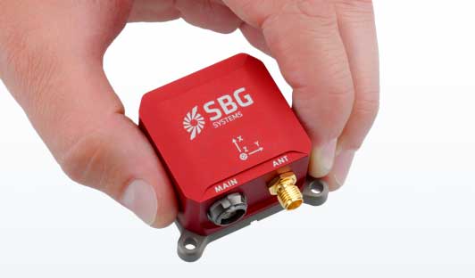
SBG Systems has built a program designed to sponsor student teams participating in competitions, as well as offer discounts for universities and research centers on inertial sensors and post-processing software.
Through the program, the company sponsors students participating in competitions in various fields, such as robotics, autonomous vehicles, UAV, rockets, unmanned and solar boats and more. This includes support during the competition, as well as during the installation of SBG’s latest inertial navigation systems in the teams’ vehicle prototype, the company said.
SBG’s Ellipse series is also eligible through its education program. The series is composed of SBG’s miniature inertial measurement units, attitude and heading reference systems and inertial navigation systems. In addition, the entire product line has been renewed. The new Ellipse INS/GNSS embeds a quad constellation, dual frequency, and dual Antenna RTK GNSS receiver to bring centimetric position and higher accuracy orientation in the smallest package, SBG added.
In addition to being compatible with CAN and ROS, the Ellipse Series’ sensors are compatible with SBG’s Qinertia Post-Processing Software, the SBG Systems’ in-house INS/GNSS post-processing software. Qinertia allows users to replay, analyze, improve their trajectories and access RTK corrections worldwide to bring their project to the centimetric accuracy.
SBG Systems designs and manufactures MEMS-based inertial motion sensing solutions. According to SBG, its products are ideal solutions for industrial and research projects such as unmanned vehicle control, antenna tracking, camera stabilization and surveying applications.
OnTerra Systems has introduced a new version of its MapSavvy aerial imagery service and a corresponding new website, www.MapSavvy.com.
MapSavvy is an affordable Web Map Service providing OGC-compliant images for anyone who needs aerial images in the course of their work or research.
The new version of MapSavvy offers users access to two versions of Bing Maps aerial imagery: original Bing Maps imagery and the recently updated aerial imagery updates introduced in 2017.
Typical users of MapSavvy are GIS and CAD professionals from business, research, or government organizations that need to use aerial imagery as part of projects, presentations, reports, or visual analysis of trends.
Examples of MapSavvy users include:
Architects and developers: Architects and developers use MapSavvy in GIS and CAD applications to obtain aerial imagery of construction sites to incorporate into projects, proposals and presentations that show where new buildings or structures would be located in the context of an existing built environment.
Research teams: Research teams use MapSavvy in GIS and CAD applications to access aerial imagery that will be incorporated into research reports, or to be able to spot trends by visually depicting information on top of an aerial image. MapSavvy is used for wildlife tracking, hydrology, environmental programs and a host of research activities.
Public safety: Law enforcement teams use MapSavvy to access base map where crimes are occurring, either to spot trends or to help solve a specific criminal case.
City planning: City planners use MapSavvy to see base map aerial views of cities, municipalities and unincorporated areas as part of their process of planning city infrastructure and new developments.
Oil and gas: Oil and gas companies use MapSavvy in GIS and CAD applications to view aerial imagery to plan for pipeline facilities placement.
The new MapSavvy aerial imagery service offers the flexibility of access to original Bing Maps imagery as well as the new updated aerial imagery introduced in 2017. The original Bing Maps imagery offers the highest resolution. The newly updated Bing Maps imagery offers the most up-to-date imagery of developed areas that have undergone changes to streets and buildings, or wild land areas that have seen changes due to geological shifts or wildfires.
“By offering MapSavvy users access to the original Bing Maps imagery and the new updated imagery, users get the best of both worlds,” said Steve Milroy, OnTerra Systems president. “This new version of MapSavvy lets users access original Bing Maps imagery if their application requires high-resolution images, or access recently updated Bing maps imagery if they require the most up-to-date images showing changes to cityscapes or wild lands.”
Example of unusual detected signal type likely to have an impact on GNSS performance. (Figures courtesy of Nottingham Scientific Ltd.)
Presented at the European Navigation Conference, Switzerland, May 2017
This paper summarizes major findings from the first year of monitoring by the International Knowledge Exchange, Experimentation and Exploitation (STRIKE3), a new European initiative to support the increasing use of GNSS within safety, security, governmental and regulated applications and addressing concerns about GNSS denial of service attacks. STRIKE3 monitors the international GNSS threat scene to capture the scale and dynamics of the problem and works with international GNSS partners to develop, negotiate, promote and implement standards for threat reporting and receiver testing through an international GNSS interference monitoring network.
European economies are now dependent on uninterrupted access to GNSS services. At the same time, GNSS vulnerabilities are being exposed, and threats to denial of GNSS service are increasing. We must ensure that there is a common standard for GNSS threat monitoring and reporting, and a global standard for assessing the performance of GNSS receivers and applications under threat. This will ensure the dominance of GNSS as the backbone to our positioning, navigation and timing needs.
STRIKE3 has built a network of more than 20 interference monitoring sites in 14 countries. This enables STRIKE3 to assess the incidence of deliberate jamming versus unintentional interference to be estimated, as well as comparisons of the most common types of interference at different types of location. Detailed data about the interference signals is collected and used in the creation of test standards. Common signal types as well as unusual ones that are likely to have a major impact on GNSS performance are extracted from the database and added to a test methodology. These will be used to test different types of receivers to better understand impact and help improve mitigation, finally leading to an international test specification.