Hoptroff’s Traceable Time as a Service to become an option for Orolia’s product portfolio; webinar scheduled for Dec. 15
Orolia and timing solutions provider Hoptroff are partnering to deliver a service combining Orolia’s resilient positioning, navigation and timing (PNT) solutions with Hoptroff’s timing synchronization software.
The collaboration will offer Hoptroff’s Traceable Time as a Service (TTaaS) as an add-on to Orolia’s suite of products, providing precise and verifiable time to customers in enterprise, financial, telecom, utilities, public safety, and other markets where traceable time is critical.
Webinar scheduled
Orolia and Hoptroff will host a joint webinar to discuss the partnership and new resiliency options for customers on Dec. 15 at 12 p.m. EST. Register here.
Hoptroff’s TTaaS offers an additional level of security and precision to meet stringent regulatory and resilient infrastructure requirements by delivering accurate time over the network using a VPN connection over broadband or fiber networks.
The bundled solution will simplify the challenge of getting accurate, traceable time in applications where GNSS access is not available or dependable. It can also serve as an accurate, reliable backup to GNSS to provide a high level of resiliency to timing systems being used in critical infrastructure.
“As industries evolve and computer applications become more complex and widely distributed, it is essential that devices in a distributed process share the same accurate timescale to reconstruct digital events after the fact,” said Tim Richards, COO at Hoptroff. “Network-based traceable timing, such as TTaaS, provides resilient backup to a GNSS installation in the case of signal disruption, monitors the quality of performance of time servers, and keeps a record of this timing quality at a location of the customer’s choice. Our partnership with Orolia means businesses will now be able to back up and monitor physical time servers and virtual servers in the cloud, so that they can be sure they share the same accurate timescale, and they have the records to prove it.”
“The partnership with Hoptroff aligns with Orolia’s resilient PNT strategy by providing a wireline solution to augment its space-based PNT solutions. This allows us to further simplify the challenge customers face when building a highly resilient timing solution,” said Jeremy Onyan, Orolia’s director of time sensitive networks. “By combining Orolia’s anti-jamming and anti-spoofing solutions, high-performance GNSS-based timing products, alternative signals like STL, a local high-quality oscillator, and now a wireline-based TTaaS we have one of the most robust portfolios of resilient PNT solutions in the market. Additionally, with the recent acquisition of Seven Solutions, we are well positioned to extend our capabilities into high-accuracy time distribution.”
Seven Solutions is a global innovator in White Rabbit sub-nanosecond time transfer and synchronization technology. “With the capability to distribute time with little to no accuracy loss, Orolia’s customers using Hoptroff’s TTaaS or other time references such as GNSS can extend that time to other parts of their networks and create a high level of resiliency against potential outages,” Onyan added.
Merger to deliver high-end performance and ultra-accurate timing and frequency products for commercial, critical infrastructure and defense markets worldwide
Orolia has entered into a definitive agreement to acquire Seven Solutions, a global innovator in White Rabbit sub-nanosecond time transfer and synchronization technology. This transaction is subject to customary closing conditions and approvals required by the Spanish government and is expected to close before the end of the year.
This is Orolia’s 11th acquisition in the past seven years.
The merger with Seven Solutions, based in Granada, will enhance Orolia’s portfolio for defense, aerospace, data centers, telecom, financial services, smart grids and other critical infrastructure industries, and will enable the next-generation applications dependent on ultra-precise, resilient timing and frequency technology.
“Orolia and Seven Solutions under one umbrella will combine our world-leading technologies to draw a new frontier in network timing to sub-nanosecond levels, delivering the most robust and accurate resilient PNT solutions for our customers,” said Orolia CEO Jean-Yves Courtois. “Seven Solutions’ long history of delivering cutting-edge time distribution solutions to sectors like telecommunications, smart grids, aerospace, defense and scientific facilities aligns perfectly with Orolia’s DNA.”
Orolia and Seven Solutions will integrate global sales, marketing, product development and operations.
Orolia’s full-scale, modular approach to resilient PNT includes atomic clocks with a combination of GNSS signals protected with interference detection and mitigation technology, together with low-Earth-orbit secure alternative signals. The addition of Seven Solutions’ products will deliver terrestrial sub-nanosecond time distribution from distant and potentially redundant locations.
“We believe the union of our companies will produce the future of time transfer and frequency distribution solutions in terms of accuracy, reliability and interoperability,” said Rafael Rodriguez, chief technology officer and co-founder of Seven Solutions. “Finance, 5G telecommunications, data centers and hyperscalers have new and upgraded functionalities requiring ultra-accurate time distribution accuracy. To maximize interoperability, our solution for time transfer is based on the White Rabbit concept that has been pushed over the last decade to become the basis of the standard high accuracy time transfer profile (within the recent release of IEEE 1588 of precision time protocol).”
Orolia and Seven Solutions are members of the Open PNT Industry Alliance. The international organization focuses on market concepts that strengthen economic and national security by supporting government efforts to implement resilient PNT capabilities for critical infrastructure.
This week Sen. Patrick Leahy (D-Vt.), chair of the Senate Appropriations Committee, released that body’s version of nine different appropriations bills. The accompanying report for the bill to fund the Transportation Department (DOT) outlines the Senate’s intentions and way forward for establishing alternatives to GPS.
The report provides $15 million for the fiscal year that began on the first of October “to establish a program that leads to wide adoption of multiple technologies that provide the necessary GPS backup and complementary PNT as identified by the Department’s report.”
The department report referenced was on a demonstration project that examined GPS backup and complementary technologies from 11 different vendors. That DOT report found, based on the technologies demonstrated, a combination of signals delivered from space, terrestrial low frequency (LF) and ultra-high frequency (UHF) broadcasts, and fiber would best meet the nation’s needs.
The Senate report accompanying the funding bill outlines components of the GPS alternatives program, including:
development of safety-critical PNT requirements and standards,
user adoption models to facilitate responsible use of resilient PNT, and
procurement of services deemed appropriate by the department.
The Senate Committee report can be found here. Relevant provisions are on page 12.
Services Contracts
While not setting a deadline for issuance of a Request for Proposal, the mention of procuring services is seen by many as a strong indication that Congress expects more than just additional studies.
Services contracts, as opposed to the government building its own system, have long been advocated by numerous members of industry and by the Resilient Navigation and Timing Foundation. Contracting for services with commercial providers is a better model, they have argued, as the needed technologies are mature and commercially available. Also, issuing one or more services contracts would avoid the need for the huge funding lines and lengthy delays inherent in a government major systems acquisition.
Many have suggested that services contracts would also be a much more economical approach for the government. They say commercial interests can operate their systems more efficiently, and that they could offer additional services to other customers, potentially reducing costs to the government.
ADS-B Sets Example
Such an approach was used by the Federal Aviation Administration (FAA) for the ADS-B air traffic safety and management system. The FAA needed to monitor and use signals from ADS-B equipment aboard a wide variety of aircraft flying in U.S. airspace. Rather than building a nation-wide ground infrastructure, the FAA issued a long-term service contract for a company to collect and provide the signals. The awardee, Exelis (now L3Harris), won the contract, built the infrastructure, and now provides ADS-B information to the FAA and others on a subscription basis.
Most observers expect the portions of the Senate bill and report about the GPS alternatives program to be adopted in conference with the House and then enacted into law.
How far the Department of Transportation will be able to develop the program this fiscal year remains to be seen. The Senate provisions do require DOT to report on its progress in a year’s time. Earlier informal reports and updates to the committee are likely to inform funding and other legislation on this effort for fiscal year 2023.
Dana A. Goward is President of the Resilient Navigation and Timing Foundation
Admiral Lord Alan West of Spithead has served the United Kingdom as First Sea Lord and led the government’s efforts for counter terrorism and cybersecurity. He has been a member of the House of Lords since 2007 and has stayed engaged with defence and maritime issues. RNT Foundation President Dana A. Goward spoke with him in early September about the UK’s way forward for GPS-like services.
DG: The UK government has been talking for years about the nation’s vulnerability to disruption of space-based signals such as those from GPS and Galileo. What is being done about it?
LW: Unfortunately, the government is not being as transparent as we might like on this. I do know from comments made in the House of Lords that there is a group developing a strategy. Also, that the Cabinet Office — our equivalent of the National Security Council in the United States — is deciding who is to be in charge and how things will be run.
I have heard the strategy group will propose a mix of technologies such as has been discussed in the United States. The idea of having several different systems, I am sure, is so that something interfering with one won’t disrupt them all.
This is all supposed to published in November. But I am concerned that government distractions with COVID, Afghanistan and other issues will delay that.
DG: What about the OneWeb project? That doesn’t seem to be waiting for a November announcement. And there is talk it may provide GPS-like timing and navigation services.
LW: OneWeb is moving forward, but at present it is only about 5G and making it available more quickly and broadly. There may be a OneWeb Phase 2 that includes modified or additional satellites to provide positioning, navigation and timing (PNT), but that is to be decided.
Admiral Sir Alan West, then First Sea Lord, is pictured with the official chart of anchorages for the International Fleet Review. (Photo: DP Kilfeather’s book Trafalgar 200 Through the Lens, Queen Elizabeth II 80th Birthday Edition, CC BY-SA 2.5)
DG: How about the UK rejoining Galileo?
LW: Actually, that makes a lot of sense from a practical point of view for both the UK and Europe. Unfortunately, there were a lot of hurt feelings on the continent with Brexit, some EU leaders seemed to be in punishment mode, and expulsion from Galileo was part of the fallout. I think that in due course as tempers cool, we will fully re-engage with the European Space Agency.
DG: So, no UK project for a GPS equivalent?
LW: The government allocated £90 million to that, which enabled a thorough look at the idea but was woefully inadequate to even start a project. Doing a British version of GPS or Galileo would be hugely expensive and doesn’t make sense. There are better, cheaper ways of getting what we need.
DG: And what does the UK need? What is the goal?
LW: We need several things.
First, we need a global capability that is ours, or that we are closely partnered in, to support the UK’s worldwide military and economic interests.
We also need to have something in place so that, even if space is denied to us — and that is getting to be more and more of a threat each day — we can keep our industries, critical infrastructure and economy going at home.
And third, we need a resilient PNT capability as a foundation for current applications, and to build on for such things as autonomy, intelligent transportation, and the like.
DG: So how do you get there?
LW: For the global bit, the OneWeb, and perhaps an even closer partnership with the United States on GPS.
At home, we definitely need a sovereign capability for when space is denied by solar weather or our adversaries. Also to be a check on space signals because our adversaries and criminals are spoofing them more and more.
I have always thought eLoran was a good choice. The UK pioneered its development and had the world’s first operational system in 2015. It is really hard to interfere with the signal, and there are other features that could be added to it that would make it even more robust.
There was a very interesting report called MarRINav put out last year about what UK maritime needs to ensure it can navigate regardless of whether the satellites are working or not. They came up with a reasonably inexpensive combination of systems anchored by eLoran.
By the way, it is interesting that the MarRINav study was funded by the European Space Agency. They seem to understand that satellites are not the be all and end all for PNT services.
DG: That all seems pretty straightforward and the right thing to do. What’s standing in the way?
LW: Well, so few people understand the problem. The population as a whole is almost completely unaware. At some level government understands all 13 of our critical infrastructure sectors could be impacted, but the people senior enough to drive action have dozens of other issues to deal with that probably seem more urgent.
DG: I wonder what it will take to make it seem urgent enough.
LW: Let’s hope the wakeup call is something short of a national disaster.
Critical infrastructure services such as telecommunications, utilities, transportation and defense are of national strategic importance. The U.S. Cybersecurity and Infrastructure Security Agency (CISA) lists 16 such sectors considered vital for security. Presidential Policy Directive 21 (PPD-21): Critical Infrastructure Security and Resilience advances a national policy to strengthen and maintain secure, functioning and resilient critical infrastructure.
Together, positioning, navigation and timing (PNT) are necessary for the functioning of a nation’s critical infrastructure. However, ubiquitous use of GPS as the primary source of PNT information introduces vulnerabilities. CISA, through the National Risk Management Center, works with government and industry partners alike to strengthen the security and resiliency of the national PNT ecosystem in the U.S. In early 2020, Executive Order (E.O.) 13905 on Strengthening National Resilience through Responsible Use of Positioning, Navigation, and Timing (PNT) Services was signed to strengthen, through policy promotion, the responsible use of PNT services by government and infrastructure operators.
The following is a review of cost considerations and exploration of the three key elements for critical infrastructure that help to strengthen PNT, focused on synchronization and precise timing: redundancy, resiliency and security.
Evaluating Cost and Location
It is often hard for operators to justify the resiliency, redundancy and security costs associated with deploying these capabilities at every layer of the architecture. New timing and synchronization solutions and design choices are leading to the right cost structures to deliver robust and reliable solutions.
The dilemma between cost and solution type is typically related to which deployment location is considered. With the evolution of technologies such as the migration from SDH/TDM to Ethernet and the development of LTE/4G and 5G in mobile, the number of aggregation offices and, above all, of network access sites at the edge has exploded. This inevitably leads to devices becoming much smaller, typically 1U-rack mountable devices, and with a cost in line with the much smaller size of edge base stations (small cells and gNodeBs).
Operators are left with the question: What is the best way to provide redundancy, resiliency and security in this environment? There are two core levels to consider — the architecture level and design level.
Exploring Redundancy
Redundancy at the architecture level can be engineered with core functions at both ends of a deployment (east/west) with dual paths for directional redundancy and high-performance capabilities for efficient high-accuracy time transfer over the long haul for cost-effective distribution. The virtual Primary Time Reference clock (vPRTC) architecture is such an architecture-level solution.
Redundancy can also be considered in the device itself, where the design choices are critical. Smaller devices cannot realistically be cost-effectively designed with modular hardware redundancy. The innovation here is to offer software redundancy, so a distributed, low cost, efficient and high-performance distributed solution can be deployed. A hardware module is typically expensive for two reasons: cost, and because the redundant module takes the space of another module, typically for input and output ports.
Hardware module redundancy often leads to a tradeoff between adding redundancy and losing capabilities, such as a choice between 10-gigabyte Ethernet (GE) support or multi-band GNSS or other compromises if redundancy is enabled. On the other hand, with software redundancy no tradeoff is necessary. Redundancy can be introduced while preserving all existing capabilities; no inputs or outputs are eliminated, no multi-band GNSS capability is eliminated. Redundancy is introduced via a software upgrade; therefore, it does not remove any hardware. Hardware redundancy, however, means duplicating an existing module with a similar module inside the device; this new module takes the slot of an existing module, and the function of that existing module is lost when it is removed from the unit.
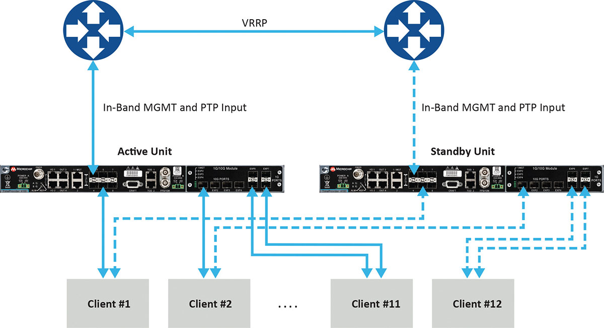
Figure 1 depicts a commonly deployed redundancy use case with two aggregation routers using virtual router redundancy protocol (VRRP).
Figure 1. Example of redundancy connectivity between the active and standby units. (Image: Microchip)
Software redundancy is a dual-unit scheme based on two reasonably priced devices, one active and the other on standby. It is more cost-effective for two reasons. First, it does not involve a costly device design with expensive hardware modules. Second, each unit (passive and active) keeps all of its capabilities compared to a hardware redundant design, which involves duplication of modules in the device, thus reducing the existing possible capabilities to host the redundant module.
Software redundancy provides total redundancy of the whole device because the active and standby units are the same. One hundred percent of the capabilities are redundant, including oscillator, GNSS receiver, ports and input/outputs. A hardware module is only redundant for its own features, not the rest of the unit.
Leveraging Resiliency
Resiliency at the architecture level is key to engineering the network so grandmasters in the deployment can be connected to each other. Some grandmasters are connected to GNSS as their source of time and frequency. It is key to connect these systems to other 1588 grandmasters to enable assisted partial time support (APTS) and to leverage key innovation such as automatic asymmetry correction (AAC).
AAC is a key (patented) differentiator in a resilient design that enables calibration of the different paths a PTP flow may use to/from upstream grandmasters, thus allowing for a backup in case GNSS fails at the location of a grandmaster. A backup path to an upstream grandmaster can guarantee uninterrupted and precise time and phase operation. This architecture makes sure that GNSS can be backed up by IEEE 1588 Precision Time Protocol (PTP) when GNSS is interrupted, with the best path being utilized.
The alternative architecture choice is virtual PRTC (vPRTC), which enables operators to leverage redundancy and resiliency via a chain of high-performance boundary clocks using PTP over long distances for high accuracy, typically over optical networks. This architecture reduces reliance on GNSS and uses PTP as its primary source of time and phase.
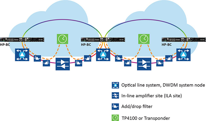
Figure 2 depicts an optical network deployment with a dedicated optical timing channel (OTC) for high-accuracy distribution of phase over long distances.
Figure 2. Optical network deployment with OTC. (Image: Microchip)
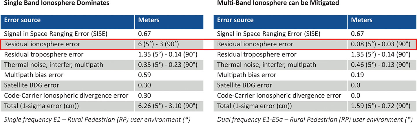
Resiliency at the device level starts with the right choice of an oscillator, from OCXO to atomic clock (Rubidium) — and is dependent on the location, use case and respective requirements for timekeeping holdover performance. Also, the choice of GNSS receiver is key. Some typically support a single frequency, yet ionospheric phenomenon can create significant time delays during cyclical events such as solar storms. To mitigate such delays, a multi-band GNSS receiver is required.
Figure 3 depicts a comparison between single-band and multi-band time delays due to ionospheric effects and shows how multiband clearly mitigates the time error as highlighted in red.
GNSS satellites transmit time information in several frequency bands. The delay difference between signals at different frequencies provides information about ionospheric impact on the absolute delay. This enables multi-band GNSS receivers to compensate for delay variations of radio signals transmitted from the satellite to the receiver. Embedding a multi-band receiver mitigates these time delays, which is critical for applications requiring Primary Reference Time Clock class B (PRTC-B),40 ns, as well as enhanced PRTC (ePRTC) 30 ns.
These device design choices are equally important. The GNSS receiver can be embedded inside the unit on the main board, or it can be offered as a hardware module, often at an additional cost, and may impact and replace an existing module that needs to be ripped and replaced. It may be preferable to have the unit enabled with a multi-band receiver and have the multi-band capability turned on via a license as opposed to offering a multiband option on a hardware module, as this becomes a tradeoff with other important capabilities.
Evaluating Security
Security is of utmost importance. Authentication and authorization via standard mechanisms such as Terminal Access Controller Access Control System + (TACACS+) and Remote Authentication Dial-In User Service (RADIUS) provide the benefit of a standard security framework. In addition, two-factor authentication (2FA) is an extra layer of protection used to ensure the security of accounts beyond just a username and password.
Also, it is key to provide Secure Shell (SSH) extensions with various levels of security profiles to offer more granularity for the types of users and related access rights and limitations. Offering high-security profiles provides for the definition and enforcement of the most stringent access rules to the system. Scripting vulnerabilities and relevant Common Vulnerabilities and Exposures (CVE) need to be addressed to make sure all potential security holes are being reviewed and addressed.
Plus, evolving jamming and spoofing threats need to be part of the precise time security strategy and implementation via monitoring of signals and consistency checks and remediation. Automatic gain control (AGC) and other metrics can be leveraged to provide thresholds with interpretation of results, as well as mitigation actions when encountered.
Final Decision Making
To ensure continued performance, it is critical to make the right architecture choices. A thorough network engineering study should include the locations where grandmaster units need to be deployed and their performance and accuracy requirements. These steps will guide which types of precise time and synchronization devices need to be selected
In addition, network planners and synchronization engineers should pay careful attention to design choices such as fanless devices versus devices that require a fan, modular hardware redundancy versus software redundancy, and the related advantages in terms of cost and tradeoffs — as well as similar choices regarding embedded or modular GNSS.
These choices can lead critical infrastructure operators to deploy redundancy, resiliency and security at all layers.
For architecture choices and solutions, visit vPRTC..White papers on this topic and others are also available. Additional information on devices and redundancy software schema is here.
Eric Colard is head of Emerging Products, Frequency & Time Systems at Microchip. He leads the product line management for Microchip’s TimeProvider 4100 and Integrated GNSS Master solutions for the telecom, utility and other industries.
What should the new administration’s priorities be to make PNT more resilient?
We asked Brad Parkinson, the “Father of GPS” and a GPS World Editorial Advisory Board member, what the new U.S. administration’s priorities should be to make positioning, navigation and timing (PNT) more resilient. For more answers from board members, see below.
Brad Parkinson
Protect the Spectrum. Reverse FCC authorization for relatively high-powered Ligado transmitters that have been proven to degrade GPS and other GNSS operation for thousands of PNT users. All U.S. government departments and major user groups affected have pleaded with the FCC to reverse this terrible decision. There is little benefit from it to the American public.
Protect the rapidly evaporating and self-proclaimed Gold Standard of GPS. The GPS satellite designs are showing their age. They need to go to multiple launch (three at a time) and revert to simpler designs without the spot-beams and other weighty add-ons that greatly increase complexity and cost. The Chinese have added to BeiDou (a) inter-satellite precision ranging and wide-band communications, (b) geosynchronous satellites, probably with good spot-beam acquisition aids, and (c) a WAAS-like correction directly on the satellites, which may have accuracies down to real-time kinematic (RTK, perhaps a few centimeters). Also, they claim their basic accuracies to be better than GPS (it might be true!) — I think they already have operational retro-reflectors.
Allow and encourage export of the basic and quickest fix to jamming and spoofing for high-value PNT users. More than 40 years ago, we demonstrated, in hardware, a high anti-jamming receiver that could fly directly over a 10 kW GPS jammer and not be affected. We know that high-gain, digital beam-steering antennas will create close to immunity, but our manufacturers will not move this way because we cannot sell or use them on the international market.These devices, combined with inexpensive inertial components and the newer signals, would make PNT virtually immune to current threats of interference — both jamming and spoofing.
Move the military focus from alternative PNT techniques to seriously upgrading their receivers and useful signals. No current or reasonably anticipated alternative can provide the accuracy (3D), availability or integrity of GPS. The new M-code and L1C signals have been in the queue for about 20 years. (Loran for ground operations probably is very vulnerable to direct attack in a fluid battlefield operation. Loran’s main value is to distribute time and for maritime users.) In those 20 years, we now have cellphone chips costing less than $5 that can listen to about 200 ranging signals and process RTK, as well as use all the corrections available (WAAS, EGNOS, etc.). Such capability cannot be found in military receivers. The Defense Department must improve its acquisition strategy in terms of both speed and competition, and ncorporate existing civil capability into military user equipment.
Take government actions to rapidly identify, shut down, and prosecute GPS jammers. Some believe this problem is much larger than recognized already. All cellphones should be required to report extraordinary spectrum noise levels or apparent attempts at spoofing. This should be fed to a dynamic national database, perhaps maintained by the Coast Guard. GPS users should have an automated way to find out whether there are substantial threats in their operating area.
Brad Parkinson is the Edward Wells Professor, Emeritus, Aeronautics and Astronautics (recalled) and co-director of the Stanford Center for Position, Navigation and Time at Stanford University.
Editorial Advisory Board PNT Q&A
Here are additional responses to the question from more GPS World Editorial Advisory Board members.
John Fischer
“We hope the new administration continues on the path established with the Executive Order last year for resilient PNT, supporting progress made by DHS and NIST in establishing resilient and cybersecure frameworks. It will be important for them to maintain an open market concept toward future innovative solutions and not mandate a particular PNT approach. Awareness of the criticality for trusted PNT in our mobile connected society is established and we must not lose this.” John Fischer Orolia
Jules McNeff
“Resilient PNT should be a national security priority. Its continuity is vital to both military and economic/social activities of all kinds. Its qualities of spatial awareness and synchronization enable the efficient functioning of the most sophisticated modern technologies in the physical and cyber worlds while also simply getting people and things from point A to point B on schedule. In that context, the elements which comprise resilient PNT should be protected from natural or hostile disruption.” Jules McNeff Overlook Systems Technologies
Greg Turetzky
“Truly resilient PNT requires combining multiple positioning technologies to maximize resiliency. However, the government’s influence in many of the augmentation technologies (sensors, vision, etc.) is limited. What the administration can do is make GPS itself more resilient by speeding up the launch and acquisition schedule of GPS Block III. The new signals, particularly at L5, are invaluable for improved resiliency to jamming and spoofing as well as providing a significant improvement in accuracy.” Greg Turetzky Consultant
Responding to letters from industry, National Security Institute (NSI) Executive Director and Professor Jamil Jaffer said he determined that three of the issues raised, while not fatal to the document, warranted clarification.
ELoran callout. The first was a statement in the backgrounder that the National Timing Resilience and Security Act (NTRSA) “specifies 13 technical requirements for a GPS backup, which essentially define the eLoran system.”
This was a concern to some on the hill as Congress is generally reluctant to specify solutions. Legislators prefer to specify outcomes and then defer to the executive branch on how to make them happen.
Members of industry pointed out that government systems like WWVB and the low-frequency portion of DARPA’s STOIC program, as well as commercial systems like NextNav and Locata, could meet or be adapted to meet the NTRSA requirement.
The revised backgrounder says the NTRSA “specifies 13 mainly technical requirements for a GPS back-up, which align closely with the capabilities of the eLoran system. Other systems may meet the Act’s requirements to varying degrees.”
Multiple technologies. The revised backgrounder also corrects a statement that the NTRSA requires the Department of Transportation to establish an eLoran system. It now says “a system that complies with the Act, and DOT may pursue multiple technologies in implementing the Act.”
Department officials had previously said they were taking a system-of-systems approach and expected to employ multiple technologies. Subsequently, a DOT report was released that documents the need for several diverse systems. It lists transmissions using low frequency (eLoran, STOIC), ultra high frequency (NextNav, Locata) and L-band from space (GPS, Satelles). It also says the terrestrial transmitters should be interconnected by fiber.
Public-private partnership. A third correction was made in the document to reflect how the Congressional Budget Office regarded the possibility of using a public-private partnership in previously proposed legislation.
Members of industry also expressed concern that one of the authors of the document serves on the advisory board for Satelles Inc. and that this was not disclosed in the paper. The backgrounder appeared on the Satelles website the same day it was published.
The university concluded that such disclosure was not necessary as the paper said the author “provides advisory services to industry, including in the PNT area.” At the author’s request, though, his profile on NSI’s webpage will be updated to show his relationship with Satelles.
Senate joined House to override Trump’s veto, making bill into law
The U. S. Congress, especially the Armed Services Committees, have long been concerned about GPS and positioning, navigation and timing (PNT) issues. Over the past two decades, Congressional hearings, demands for reports and investigations have dealt with acquisition, contingency plans for when space is not available, deliberate interference, and a host of other issues.
While these all evidenced Congress’ interest and concern, they were relatively passive measures.
This began to change in 2018 with passage of the National Timing Resilience and Security Act. It requires the Department of Transportation to establish a terrestrial timing system to backup GPS signals.
Then in 2019, Congress appropriated money for a GPS Backup Technology Demonstration. And the National Defense Authorization Act (NDAA) for 2020 required the Air Force to develop a prototype multi-GNSS receiver as part of its resiliency efforts.
The NDAA for 2021 seems to finalize Congress’ transition from an interested observer, mostly on the sidelines, to an active player in national PNT issues and policy.
GPS Under Threat
Capitol Hill observers say this is the result of several factors that have come to a head over the last year. Taken together, they have convinced many legislators that GPS is under threat and PNT issues are not being taken seriously enough by the executive branch. These include increased jamming and spoofing (especially by China and Russia), full implementation of China’s BeiDou system and its marketing to other nations as a superior alternative to GPS, the Federal Communications Commission’s (FCC) decision on Ligado Networks, and the Pentagon’s failure to respond to combatant commanders’ Joint Urgent Operational Needs Statements for non-GPS PNT.
Here are some of the provisions of the 2021 NDAA of interest to the PNT community.
Military Multi-GNSS Prototype
The 2018 NDAA required the Defense Department to incorporate Europe’s Galileo and Japan’s QZSS satellite navigation signals into military user equipment. The idea was to make it more resilient to disruption. Also required was an investigation into using non-allied signals.
Apparently not satisfied with progress on this project, Congress mandated a project to develop a prototype multi-GNSS receiver as part of the 2020 NDAA.
The 2021 NDAA seems to indicate Congress is still not happy. It withholds 20% of the funding for the Office of the Secretary of the Air Force until the department certifies the prototype project is underway and provides briefings to the Senate and House Armed Services Committees.
Resilient, Survivable PNT
Language in the 2021 NDAA also seems to show Congress is impatient with the Pentagon’s lack of responsiveness to combatant commanders’ requests for non-GPS PNT systems.
Section 1611 of the act is entitled “Resilient and Survivable Positioning, Navigation, and Timing Capabilities.” It requires development, integration and deployment of these capabilities for combatant commanders within two years. This, it says, is “… consistent with the timescale applicable to joint urgent operational needs statements…”
The act says the new PNT capabilities shall “generate resilient and survivable alternative positioning, navigation, and timing signals” and “process resilient survivable data provided by signals of opportunity and on-board sensor systems…”
The act also addresses the Defense Department’s 2018 PNT Strategy’s plan for future systems to be classified and for military use only. It directs the department to work with the National Security Council, Departments of Transportation, Homeland Security and others “…to enable civilian and commercial adoption of technologies and capabilities for resilient and survivable alternative positioning, navigation, and timing capabilities to complement the global positioning system.”
To help ensure prompt action on this, the act requires a report to Congress within six months and authorizes the department to reprogram funds from other areas to finance the effort.
Responding to Ligado Decision
By far the most PNT-related text in the 2021 NDAA includes a host of measures responding to FCC Order 20-48 approving an application by Ligado Networks. An order that the executive branch is on record as strongly opposing, saying it will degrade GPS service for many.
Senator Jim Inhofe, chair of the Senate Armed Services Committee, has regularly expressed outrage at the FCC’s decision and has called for its reversal.
Among its provisions, the act:
requires the Department of Defense to estimate and report to Congress the cost of damage to department systems as a result of the FCC order.
prohibits using department funds to upgrade or modify military equipment to make it resilient to interference caused by broadcasts in the spectrum allocated (the FCC order requires this to be funded by Ligado).
prohibits contracting with any entity using the frequency bands allocated to Ligado unless the Secretary of Defense certifies the use will not interfere with GPS services.
requires the Secretary of Defense to contract with the National Academies of Sciences, Engineering, and Medicine for an independent technical review of the FCC order.
Dana Goward is president of the Resilient Navigation and Timing Foundation (rntfnd.org).
Germany is the first United States ally to order the new military code (M-code)-capable Military GPS User Equipment (MGUE).
The Space and Missile Systems Center’s Space Production Corps achieved the major milestone on Sept. 30, when GPS Foreign Military Sales (FMS) office received its first M-code MGUE order.Germany is expected to receive delivery of its first M-code receivers this year.
SMC is facilitating international access and availability of M-code user equipment as directed by the Secretary of the Air Force and the Office of the Secretary of Defense to 58 authorized nations. Additional foreign military sales of MGUE are being worked.
Currently, SMC is engaged with several nations in bilateral M-code prototyping, demonstration and lead platform planning efforts. Under a multilateral agreement, MGUE ground-based receivers are on schedule to be loaned to approved partners for early integration and test in national weapons systems.
M-code is an upgrade to the currently available GPS signals that provides enhanced secure positioning, navigation and timing (PNT) performance, anti-jam and anti-spoofing to provide a more resilient PNT solution. It will improve interoperability with our defense partners’ equipment and operations while increasing navigation warfare effectiveness for allied operations.
Senate poised to join House this week and override Trump’s veto
The U. S. Congress, especially the Armed Services Committees, have long been concerned about GPS and positioning, navigation, and timing (PNT) issues. Over the last two decades Congressional hearings, demands for reports, and investigations have dealt with acquisition, contingency plans for when space is not available, deliberate interference, and a host of other issues.
While these all evidenced Congress’ interest and concern, they were relatively passive measures.
The NDAA for 2021 seems to finalize Congress’ transition from an interested observer, mostly on the sidelines, to an active player in national PNT issues and policy.
This began to change in 2018 with passage of the National Timing Resilience and Security Act. It requires the Department of Transportation to establish a terrestrial timing system to backup GPS signals.
Then in 2019, Congress appropriated money for a GPS Backup Technology Demonstration. And the National Defense Authorization Act (NDAA) for 2020 required the Air Force to develop a prototype multi-GNSS receiver as part of its resiliency efforts.
The NDAA for 2021 seems to finalize Congress’ transition from an interested observer, mostly on the sidelines, to an active player in national PNT issues and policy.
Capitol Hill observers say this is the result of several things that have come to a head over the last year. Taken together, they have convinced many legislators that GPS is under threat and PNT issues are not being taken seriously enough by the executive branch. These include increased jamming and spoofing (especially by China and Russia), full implementation of China’s BeiDou system and its marketing to other nations as a superior alternative to GPS, the Federal Communications Commission’s (FCC) decision on Ligado Networks, and the Pentagon’s failure to respond to combatant commanders’ Joint Urgent Operational Needs Statements for non-GPS PNT.
Photo: Andrea Izzotti/Shutterstock.com
Here are some of the provisions of the 2021 NDAA of interest to the PNT community.
Military Multi-GNSS Receiver Prototype
The 2018 NDAA required the Defense Department to incorporate Europe’s Galileo and Japan’s QZSS satellite navigation signals into military user equipment. The idea was to make it more resilient to disruption. Also required was an investigation into using non-allied signals.
Apparently not satisfied with progress on this project, Congress mandated a project to develop a prototype multi-GNSS receiver as part of the 2020 NDAA.
The 2021 NDAA seems to indicate the Congress is still not happy. It withholds 20% of the funding for the Office of the Secretary of the Air Force until such time as the department certifies the prototype project is underway and provides briefings to the Senate and House Armed Services Committees.
Resilient Survivable PNT
Language in the 2021 NDAA also seems to show Congress is impatient with the Pentagon’s lack of responsiveness to combatant commanders’ requests for non-GPS PNT systems.
Section 1611 of the Act is entitled “Resilient and Survivable Positioning, Navigation, and Timing Capabilities.” It requires development, integration, and deployment of these capabilities for combatant commanders within two years. This, it says, is “… consistent with the timescale applicable to joint urgent operational needs statements…”
The act says the new PNT capabilities shall “generate resilient and survivable alternative positioning, navigation, and timing signals” and “process resilient survivable data provided by signals of opportunity and on-board sensor systems.”
The act also reverses the Defense Department’s 2018 PNT Strategy’s plan for future systems to be classified and for military use only. It directs the department to work with the National Security Council, Departments of Transportation, Homeland Security and others “to enable civilian and commercial adoption of technologies and capabilities for resilient and survivable alternative positioning, navigation, and timing capabilities to complement the global positioning system.”
To help ensure prompt action on this, the act requires a report to Congress within six months and authorizes the department to reprogram funds from other areas to finance the effort.
Responding to FCC’s Decision on Ligado Networks
By far the most PNT-related text in the 2021 NDAA includes a host of measures responding to FCC Order 20-48 approving an application by Ligado Networks. An order which the executive branch is on record as strongly opposing saying it will degrade GPS service for many.
Senator Jim Inhofe, chair of the Senate Armed Services Committee, has regularly expressed outrage at the FCC’s decision and has called for its reversal.
Among its provisions the act:
Requires the Department of Defense to estimate and report to Congress the cost of damage to department systems as a result of the FCC order.
Prohibits using department funds to upgrade or modify military equipment to make it resilient to interference caused by broadcasts in the spectrum allocated (the FCC order requires this to be funded by Ligado)
Prohibits contracting with any entity using the frequency bands allocated to Ligado unless the Secretary of Defense certifies the use will not interfere with GPS services
Requires the Secretary of Defense to contract with the National Academies of Sciences, Engineering, and Medicine for an independent technical review of the FCC order.
The ROSS project, conducted in France by companies Marlink and SeaOwl, demonstrated the feasibility of autonomous shipping. Orolia systems ensured resilient PNT. (Photo: Marlink)
The International Maritime Organization (IMO) has issued a resolution for maritime cyber-risk management, effective January 2021. IMO Resolution MSC.428(98) affirms that maritime operators need to address cyber threats that risk the integrity and availability of technology systems.
GPS/GNSS signal jamming and spoofing expose the vulnerabilities of PNT-reliant systems. The single point of failure in the signals used to synchronize military operations or determine a vessel’s location leaves maritime systems open to attack. With resilient PNT, maritime and naval vessels can rely on trusted data.
Remote Operations at Sea. In September, Orolia participated in a Remotely Operated Service at Sea (ROSS) demonstration where an unmanned vessel was tele-operated from more than 800 kilometers (500 miles) away.
With its SecureSync Interference Detection and Mitigation (IDM) suite, Orolia provided the project’s PNT cybersecurity package and delivered precise, reliable data for the control center to pilot the vessel from afar. The IDM suite includes GNSS threat detection and mitigation, as well as the option to include encrypted and alternative signals for use in GNSS-denied environments.
After this successful demonstration, SeaOwl Group, the company leading the ROSS project, obtained the first remotely operated vessel navigation license in France.
Diving Deep. Atomic clocks and oscillators are useful for underwater operations where RF signals are unavailable to provide accurate PNT data. Precision timing technologies, such as Orolia’s Spectratime mRO-50 oscillator, ensure stable timing for navigation systems through radar. They support missions such as:
stabilizing and synchronizing sensor measurement data collection for autonomous underwater vehicles (AUVs)
providing holdover to maintain precise positioning on submarines during extended periods of GNSS signal denial
generating precise frequencies with low phase noise and less burden on radio receiver architecture, such as search-and-rescue control centers
operating with low power consumption and increasing the reliability of radio reception.
Resilient PNT is essential at sea, from military missions and commercial freight shipping to port management, search and rescue, research and fishing operations. Jamming and spoofing detection, threat mitigation, and alternative PNT sources configured in multiple layers of protection can ensure continuous operations, even in compromised environments. In shallow or deep-water environments, Orolia’s portfolio includes critical infrastructure support for naval command-and-control centers, essential GNSS vulnerability testing and services, and wearable solutions that fit in the palm of a hand.
Not just supporting players, alternative positioning, navigation and timing (PNT) systems strengthen, augment and — when needed — replace GNSS. GPS World explores how companies are using alternative PNT, and talks with John Fischer of Orolia about the company’s latest developments.
GPS World: What are Orolia’s latest advances and products regarding alternative PNT?
John Fischer: Regarding timing, which we have been doing for decades, our big alternatives to GNSS are internal atomic clocks and network-based timing, such as precision time protocol (PTP). Regarding positioning and navigation, the two areas on which we focus are IMUs and getting updates from GNSS, so that, when you lose GNSS momentarily, you have something on which to coast. The breakthroughs in MEMS technologies are astounding —they are getting better and cheaper every day. That shows wonderful promise.
The other area is doing satellite navigation using low Earth orbit (LEO) satellites, which are much closer to the Earth than GNSS ones and give you 30 dB or more of signal strength. We are focused the most on the Satellite Time and Location (STL) signal because it is available today. Supplementing your navigation system with updates from LEO satellites provides you some great non-GNSS navigation capability.
GPS World: The positions of LEO satellites are not monitored as closely as those of GPS satellites. Is that an issue?
JF: That is correct. You are losing accuracy by using what is available today because you do not know the positions of those satellites as well as you know those of the GNSS satellites and maybe you do not have the best geometry. All the GNSS satellites are in medium Earth orbit (MEO) because they have much better geometries for a small constellation. With just 24 satellites in MEO orbit, you get great geometries. When you go lower, you need an increasingly greater number of satellites.
The first generation of LEO satellites, the Iridium STL, are a much larger constellation, with 66 satellites, but still not enough to give you the good geometries. Today, you are getting less accuracy, but there are all kinds of new satellites being launched and the capability to track them will improve. We expect to be able to use signals from hundreds, if not thousands, of LEO satellites, so the geometry problem will start to go away and there are other things we can do to improve the accuracy. Meanwhile, we can get rather good performance with what we have today.
GPS World: What are some of your most recent advances, releases or products?
JF: On the timing side we have what we call a mini-Rubidium, the mRO-50, which we launched on June 4. Smaller, better, cheaper atomic clocks are coming out very soon.
GPS World: Do you have any comments on the recent executive order on resilient PNT?
JF: We coined the term “resilient PNT,” so we are glad to see it in use. We fully support those efforts.
GPS World: What about other alternative sources of PNT data, such as radar, lidar and signals of opportunity?
JF: Yes, they are that next level. Loran is ideal because it is so different from GNSS. When you are trying to design a reliable system, you want a lot of diversity, because if two systems have the same kinds of failure modes you have not gained in redundancy. Loran is literally at the other end of the spectrum from GNSS: It is a low-frequency microwave system. Instead of being space-based, it is land-based; instead of being low power, it is high power. However, there still are no stations up. It requires big equipment, so it will take some time.
When it comes to what you can do today, Loran does not contribute much. We support efforts to implement Loran very much, because we do need non-GNSS ways to make things resilient. Prior to GPS, we had to depend only on Loran. Today, with modern digital signal processing (DSP) techniques and receivers, I think we can expect the new Loran system to have much better accuracies than we had in the bad old days of the first generation of Loran.
The auto industry is doing a marvelous job of doing navigation using lidar or cameras. They are pretty much navigating driverless cars the way that humans drive, by just using visual cues. Those things have promise in certain unique areas.