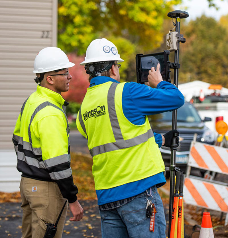
Surveying is both an ancient profession and one of today’s most technologically advanced. Surveyors are among the first on the site of a new construction project, staking out its corners and boundaries, and mapping elevation contours, as well as among the last, surveying the project “as built.” This is particularly important for features that will no longer be visible once the project is complete, such as underground utilities.
While many surveyors work in quiet, uncrowded environments — such as surveying the boundaries of farm fields — those who work on large construction projects operate among the hustle and bustle of bricklayers, carpenters, electricians, plumbers and other tradespeople, as well as cranes, backhoes and other heavy machines. This chaotic environment means that in addition to accuracy and efficiency, surveyors also are concerned with safety.
In the following cover story, a Minnesota-based construction company describes a new system it developed for surveying and mapping underground utilities. Also, professional surveyor Gavin Schrock discusses the benefits of a flexible approach to GNSS rover accuracy and of adding scanning capabilities to robotic total stations.
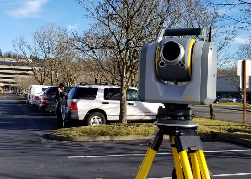
A unique workflow enabled by scanning robotic total stations is the simultaneous operation, with the same data controller and software, of a GNSS rover while scanning and imaging are being performed. Pictured: a Trimble SX12 and R12i GNSS. (Image: Gavin Schrock)
Scanning capabilities, in one form or another, have been added to models of robotic total station (RTS) since 2007 — for instance, on the Trimble VX. Such capabilities were limited to a pattern of individual shots, as the RTS would “nod.” While not designed to compete with traditional scanners, even such painfully slow “pseudo-scanning” capabilities demonstrate the value of new options for capturing detailed features.
It was not long before nearly all RTS offered limited (nodding scanning) capabilities, though at rates as slow as 15 shots per second. By 2013, the release of the Leica MS50 took the nodding scan to the next level, with a rate of up to 1,000 points per second, and then up to 30,000 in the subsequent MS60 model (which now also supports a tilting prism pole).
The end of 2016 saw the release of Trimble’s SX10 (and SX12 more recently). This routed the laser through a pair of rotating prisms to capture a swath of points as it nodded. In 2019, Topcon took the approach of adding a piggy-backed compact conventional scanner to the top of an RTS: the GTL-1000 and GTL-1200 models.
All these implementations were built upon high-quality RTS. Foremost, they can be operated as an RTS, with all the same integrated surveying capabilities as instruments with which surveyors were familiar, and in the same field software.
This includes all the integrated GNSS workflows: resections, combining optical and GNSS captured points in the same survey, and adding a rover to the prism pole for track-on-GNSS methods. One huge advantage of scanning total stations is instant deliverables already fully registered, as adopters of these new systems quickly realized.
Some initial users seemed skeptical of the relatively slow scan rates of these various models: 12 to 30 minutes for full-dome scans, and then a photo capture pass. Others, though, discovered that the time did not necessarily need to go to waste.
First, it is not necessary to do a full-dome scan and image pass every time; it is sufficient to pre-select specific areas to scan and image.
The real kicker is that while the RTS is scanning, it is possible to fire up the GNSS rover and capture points that the RTS cannot see, such as behind curbs, cars and vegetation. This is true especially now, with the advent of no-compensation tilt capabilities on nearly every new GNSS rover system.
This can be done in the same project, using the same software and field controller. This struck this writer as one of the coolest lateral features of scanning total stations when he first tried out an SX10 in 2017.
Considering the benefits scanning total stations deliver (especially with the integrated GNSS bonus), what has the reception been like among surveyors and other segments of the architecture, engineering and construction (AEC) community?
“As an industry, we’re getting better at tying solutions and workflow elements together, and not seeing them, or treating them, as individual functions or pieces of hardware,” said Derek Shanks, director of Geospatial Optical Product Management for Trimble. “We bring the system aspect, a case of using the best tool, using the strengths of each tool to their fullest.”
Accoring to multiple manufacturers, sales numbers indicate that the adoption of scanning total stations for AEC applications — and not just surveying — has exceeded expectations.
“Nothing can remain immense if it can be measured,” Hannah Arendt wrote in 1958 in The Human Condition. This could be the guiding inspiration for any geodesist or surveyor throughout history. In about 240 B.C., Eratosthenes became the father of geodesy by ingeniously measuring Earth’s circumference using the Sun, a well, a vertical column, the distance a camel caravan traveled from Syene to Alexandria and some basic mathematics. His estimate of 46,000 kilometers was 16% too large but remarkably close considering that he lacked any modern measuring tool. (For a great account of this epic feat, see John Noble Wilford’s The Mapmakers.)
Geodesy, a branch of applied mathematics, is concerned with accurately measuring and understanding three of Earth’s fundamental properties: its geometric shape, its orientation in space, and its gravity field. Earth’s true shape varies from the mathematically smooth surface of an ellipsoid due to local differences in its density that cause variations in the strength of the gravitational pull, in turn causing regions to dip below or bulge above a reference ellipsoid.
This undulating shape is the geoid, which geodesists have defined as the three-dimensional surface along which the pull of gravity is a specific constant. It serves as the zero-level surface for height measurements globally, and all GNSS are pegged to it. It is a hypothetical surface that essentially represents an extension of the idealized mean sea level over (actually, mostly under) Earth’s land surface. Unlike the surface of the oceans, however, it is unaffected by wind, waves, the Moon, or forces other than Earth’s gravity.
Surveyors are content with measuring much smaller portions of Earth’s surface, from single lots to national boundaries. Unlike Eratosthenes, they work with the latest fruit of modern science and technology — including GNSS receivers, robotic total stations, inertial measurement units, lidar, other sensors and unmanned aerial vehicles — and can measure distances with millimeter precision.
When I started in this business a little more than 20 years ago, we used to group GPS receivers by accuracy into three buckets: consumer grade, resource/mapping grade and survey grade. As accuracy has increased for all GNSS receivers, the boundaries between those categories, especially between mapping and surveying, have blurred. Additionally, we now have way more GNSS satellites — in some parts of the world, as many as 70 are in view at one time — and a panoply of public and private, ground-based and satellite-based corrections services.
So, surveyors have a growing set of tools, and they are constantly getting more accurate and more user-friendly.
Now, let me throw another number in the mix: 66. That is the average age of surveyors in the United States. In the short run, employment for surveyors hinges in part on the vagaries of the economy. In the long run, however, population growth and climate change will force large investments in infrastructure. On most construction sites, the first to arrive and the last to leave are the surveyors. We know what their tools are, but who will they be?
A module for SurvCE version 6 software enables surveying with mixed brands of GNSS receivers and total stations. SurvCE is a data-collection software package from Carlson Software. SurvPC Hybrid + provides driver support for numerous devices, allowing the surveyor to interface with both types.
Features of SurvPC Hybrid+ include:
Follow Me. An alternative to optical tracking, Follow Me continuously turns the total station towards the prism using the location as determined using GNSS. This eliminates stray reflectors and lengthy searches.
Smart Lock. The software will automatically detect when a user is slowing to take a measurement and lock on the prism so that it’s ready to go.
Smart Staking. With smart staking, it will no longer be necessary to maintain optical tracking during stakeout. Stakeout directions are kept fresh using the GNSS receiver as the surveyor approaches a stakeout point. When close to the point, the total station will automatically turn and lock on the prism for the final staking precision needed.
Cross Check. SurvCE will automatically cross-check the total station and positions determined using GNSS and warn the surveyor when they differ.
Backup Tracking. With backup tracking, SurvCE will automatically show the position determined using GNSS on the map when the total station isn’t locked.
Hybrid-Resection. Easy hybrid-resection allows for setup anywhere using positions determined using GNSS to calculate the total station occupied point and orientation. Measurements from the GPS and total station are time-synchronized for an accurate and simple one-tap resection measurement.
Auto-Localize. Simplify setup by seamlessly auto-localizing the GPS receiver as total-station points are stored.
Easy Setup Wizard. The easy setup wizard walks users through setup using auto-localization, hybrid resection or hybrid localization, then finishes with a cross-check for quick project start.
Sokkia has launched two robotic total stations designed to improve job site productivity: the iX-1200 and iX-600.
According to Sokkia, the total stations, designed as a part of a full workflow solution, are professional-level positioning tools for survey and layout in the building construction and infrastructure trades. They’re engineered for integration with field controllers, software and GNSS receivers.
In addition, advanced users can take measurements in almost any environment while switching to the most appropriate technology — total station measurement integrated with GNSS measurement — through an optional upgrade to Hybrid Positioning technology, Sokkia said. The stations also can be seamlessly integrated into BIM workflows.
“The high-performance technologies incorporated into the design provide increased prism-tracking strength,” said Ray Kerwin, director of global product planning. “Through a combination of optical sensing and ultrasonic motors, UltraTrac technology helps users stay locked onto the prism — and productive with less down time resulting from the need to reacquire prism lock — even in dynamic job site conditions. The system also features the RC-PR5A remote controller option used on the prism pole so the user can quickly and simply reestablish the connection between prism and total station.”
The total stations, available in multiple accuracy models, can be used with the SHC6000 field controller and GeoPro or MAGNET Field software for optimal performance, Sokkia added.
The new the GT series of total stations are part of a full workflow solution, including a new field computer, a full-version update to Topcon field and office software and GNSS receivers. The system is designed to work in sync for improved performance and better data handling with built-in, field-to-office connectivity.
The speed, tracking and accuracy of the GT series, combined with the intuitive software system, creates a flexible solution capable of satisfying the technology needs of surveyors and contractors performing survey, layout or machine guidance projects, Topcon said.
“The new total stations perform at a faster 10-Hz positioning update rate,” said Ray Kerwin, director of global product planning. “Combining the GT series with the new field computer and software enhancements, this tracking improvement makes layout easier and guidance more fluid, within an intuitive map view. More layout and survey points can be collected in less time.”
“Surveyors, contractors, as well as heavy machinery automation operators and other construction professionals can benefit from the time-savings and accuracy the series provides,” Kerwin said.
Advanced UltraTrac prism tracking combines optical sensing with a new ultrasonic motor control algorithm designed to maintain superior prism lock.
“Tracking fast-moving targets and maintaining prism lock is now easier on challenging job sites as well as in machine guidance applications. If you’re performing a machine control project where the prism is vibrating on the end of the blade, for instance, the GT will lock onto the prism better and provide smoother machine guidance,” Kerwin said.
Magnet software improves field-based quality reporting and data handling for larger files, graphical processing, and 3D models. Magnet Field features more visual- and map-based workflows in addition to menu-driven functionality popular with power users.
An optional upgrade incorporating hybrid positioning technology helps advanced users get instant location updates via GNSS receivers so positioning data points can be captured, even with the loss of line-of-sight from job site obstructions.
The complete GT series workflow solution — Magnet software, FC-6000 field computer, and HiPer Series GNSS receivers — combine for easy-to-use digital processes designed to help surveyors and contractors increase precision, reduce rework and improve quality control.
Spectra Precision‘s Focus 35 robotic total stations are helping build the world’s largest expressway network. For instance, the Focus 35, with its time-saving automatic scan template, is checking the cross-section quality of the twin Nan Kunshan tunnels for the new six-lane Shazhan S14 regional highway.
Excavation under Nankun Mountain for the twin tunnels, each 4.1 kilometers (km) long and each capable of carrying three lanes of vehicular traffic, began in September 2016.
In the current second phase of construction, the Focus 35 is being used to gather data that will be used to compare the as-built tunnels to the design specifications to determine what adjustments to the tunnel surfaces may need to be made.
The Focus 35 was selected for the scanning work because it offers a streamlined and efficient workflow that yields significant time-savings, the company said. The workflow of a conventional total station requires time-consuming manual scanning followed by export to a separate post-processing function after which a DXF file is generated.
The Focus 35, with its Trimble Access Tunnel software, saves significant time because it automatically scans and directly generates DXF reports for submission to the contractor to check over-break and under-break values, the company said.
When completed, the new six-lane 800-km Shazhan highway will connect Shantou and Zhanjiang, two important coastal cities in southern Guangdong province. The contractor for the Nan Kunshan tunnels is ChangDa Highway Engineering Co. Ltd.
The iX series of robotic total stations uses ultrasonic technology.
Sokkia has introduced a new line of robotic total stations. Featuring ultrasonic technology, the iX series is designed to provide smooth, accurate prism-tracking and is “lighter and faster,” according to a Sokkia news release.
“Ultrasonic technology is the driving force for the iX series,” said Ray Kerwin, director of global surveying products. “The Ultrasonic motors are the thinnest, lightest and most reliable on the market. With a rotation speed of 150 degrees per second, the iX series offers the efficiency of a single-operator robotic system and the power of long-range reflectorless measurements of up to 800 meters and 6,000 meters with a reflector.
“Our new UltraTrac technology gives you increased prism-tracking strength in all conditions. Advanced instrument algorithms deliver the confidence you need to move ahead,” he said.
The system is designed to be a compact solution and is a third smaller and lighter than previous robotic Sokkia instruments.
Along with complementing Sokkia products, the instrument is designed with an open platform for additional compatibility with non-proprietary software and controllers. The iX series also features a five-year motor warranty.
Leica Geosystems announced that it is taking the first step toward bringing live-streamed intelligent cloud-based imagery into all field applications, beginning with the launch of the Leica Nova MS60 MultiStation, Leica Nova TS60 Total Station, Leica Viva TS16 Total Station and Leica Zeno 20 handheld.
Geospatial professionals in the U.S. and Canada who invest in these new solutions can become part of this pioneering effort and add even more intelligence to their dataset with up to one year of introductory free access to georeferenced imagery from the Hexagon Imagery Program (HxIP), the company said.
A high-quality, accurate and professional dataset, HxIP imagery is 30-cm (1-foot) resolution, with set specification and accuracy standards and a regular refresh schedule. The natural color RGB backdrop imagery (tile cache) is fast and easy to access and gives context to survey and construction maps and overlays, Leica Geosystems said. All content is captured using Leica Geosystems airborne sensors for the highest reliability.
Access to HxIP imagery adds spatial and contextual awareness to surveys, enables better planning and decision-making for more efficient and productive time onsite, and eliminates the need to georeference data to the basemap during post-processing, the company said. Through Leica Infinity software, users can access HxIP imagery to view field measured data and imported design data in the office.
Users can also prepare job data with the HxIP imagery and then clip and store georeferenced images that can be exported to the new Leica Captivate field software for use as background imagery and basemaps on the newest robotic total stations. The imagery can also be live-streamed to the Leica Zeno 20 handheld.
The georeferenced HxIP airborne imagery is available to everyone on a subscription basis through the cloud via multiple content service providers, including Esri’s ArcGIS Marketplace, Hexagon Geospatial’s Power Portfolio and Valtus Imagery Services. Complimentary access to live-streamed HxIP image tiles is being offered through June 2016 to customers in the U.S. and Canada that have an active Leica Infinity Customer Care Package (CCP) or that purchase a Leica Zeno 20 handheld.
“We’re quickly moving toward a world in which every geospatial sensor will have cloud-based access to real-time, high-quality imagery for invaluable survey intelligence,” said Ken Mooyman, president of Hexagon Geosystems NAFTA. “The integration of HxIP with Leica Infinity, Captivate and the Leica Zeno 20 in North America is the first step in bringing that rich, detailed imagery to users where and when it is available so they can be part of leading the way into the future.”