It is a beautiful, crisp afternoon, the last of the summer, as I write and as we prepare for next week’s ION GNSS+ conference, where GPS World and sponsors Harris Corporation, Rockwell Collins and Spirent Federal Systems will host the 2017 Leadership Dinner and confer this year’s Leadership Awards in Satellites, Signals, Services and Products.
The engraved glass awards nestle snug in their boxes beside me, the names upon them known only by a few.
However, as you read this, it is early October — and hopefully another beautiful crisp afternoon among autumn’s best — and those glass awards are safe at home with their new owners. Their names are known by all 125 Leadership Dinner attendees, and now by you as well. We will publish their spoken remarks in the December issue. Here now are the basic details.
The voting ballot for the awards was assembled by polling a group of roughly 25 industry VIPs for their nominations, and that same group plus another 40 voted for the final recipients.
The 2017 Leadership Award for Satellites went to Wolfgang Paetsch, director of Navigation for OHB, primarily responsible for the space projects that the company executes for the European Space Agency (ESA) and the European Union. He was nominated for his leadership in setting up the routine production of the Galileo satellites leading to Galileo constellation deployment, including the quadruple Ariane 5 launch in November 2016. As one voter remarked as he cast his ballot, “The quadruple launch capability is a key enabler for the future.”
The Leadership Award for Signals was conferred upon Christopher Hegarty, director for Communications, Navigation and Surveillance Engineering and Spectrum at The MITRE Corporation, for contributions to the Department of Transportation’s GPS Adjacent Band Compatibility Assessment. Said Compatibility Assessment has been a long and winding road, and has required several sure hands, Chris’ among them, to guide it. We hope to publish something on its outcomes soon.
The Leadership Award for Services was given to Patricia Doherty, director and senior scientist at the Institute for Scientific Research at Boston College, for initiating and leading the Africa GNSS Outreach program since 2009. The program’s mission is to help developing countries derive social and economic benefits from satellite-based positioning, navigation and timing. Each year, around 50 graduate students and faculty from African and other countries attend these GNSS workshops. The faculty reads like a Who’s Who of satnav scientists and teachers, testifying to both Doherty’s formidable recruiting talents and the dedication of this community to knowledge-sharing around the world.
2017 GPS World Leadership Awards.
The Leadership Award for Products was a tri-partite affair, going to colleagues Charles Abraham and Andreas Warloe, vice president of Engineering and senior director of GPS Engineering, respectively, at Broadcom. As the chief designer and the architect of the first dual-frequency L1/L5 E1/E5 GNSS chip for smartphones, they are helping to usher in a new era of high-precision GNSS in mass-market products. See this article for more details on the just-launched product.
The two shared the award with Javier de Salas, director of Software Engineering at Broadcom, for leadership in establishing Galileo-ready receiver products.
A good time was had by all at the Leadership Dinner, which also included the PNT Powerplay Puzzle and Pig-in-a-Poke Live Auction. Details in December!
The German Ministry of Defense selected Rockwell Collins’ NavHub navigation system to provide GNSS availability to a variety of its military vehicles.
The NavHub system serves as a next-generation GNSS- and Military-code (M-code)-enabled solution for the German Armed Forces.
Customizable for ground and maritime platforms, NavHub provides a variety of vehicle interfaces, meets the standards required by military vehicle operators, and allows users to receive data from multiple secure and open-service GNSS constellations to simultaneously confirm the navigational solution.
Access to multi-constellation GNSS and GPS M-Code will provide a significantly enhanced navigational solution over the current GPS-only solution.
Work under the contract will be performed in Rockwell Collins’ facilities in in Europe.
About the NavHub GNSS navigation system
NavHub (Image:: Rockwell Collins)
Based on Rockwell Collins Selective Availability/Anti-Spoofing Module (SAASM) GPS receivers, NavHub is strategically designed to meetfast-moving and demanding combat environments.
Through the use of dual-installed GNSS receivers, NavHub provides an assured navigational solution, interfaces and GNSS upgrade path to support modern operations platforms.
SAASM security (expansion to M-code), expansion to multi constellation GNSS
Extended platform interfaces, including Ethernet, USB and CAN
Extended performance in a jammed environment (i.e., 41 dB while tracking and 24 dB during initial acquisition)
“NavHub meets the critical mission need for accurate navigation support for fast-moving platforms and challenging environments,” said Claude Alber, vice president and managing director, Europe, Middle East and Africa for Rockwell Collins. “Our military GNSS receivers will provide significantly enhanced navigational capabilities to military vehicles and will mitigate terrain, forest and urban degradation as it will raise the number of satellites used from 28 to well over 100.”
Rockwell Collins new generation GPS-4000-100 receiver
It’s still exceptionally difficult to qualify GNSS receivers for airborne use so there are only a few existing suppliers.
They include CMC Electronics with its line of OEM and enclosure products, Rockwell Collins with a new generation of airborne receivers just entering the market, Thales in Europe continuing to offer ARINC standard and multi-mode packaged receivers, Garmin still leading the panel-mount market for business aviation, Trimble/Ashtech continuing to promote its GPS/GLONASS airborne receiver, and newer entrants including Aspen/Accord with the NexNav GNSS line, and Avidyne with a home-grown embedded receiver in its flight management systems.
It’s been a while since we reviewed the status of certified airborne receivers, and I was prompted to do so by news that Rockwell Collins has a new generation of receiver which has just received Technical Standard Order (TSO) approval from FAA.
Rockwell Collins has fielded GPS products for 20+ years, and the GPS-4000S — with SBAS capability — has been fielded for more than 8 years, so parts obsolescence may become an issue. With new constellations, and with more countries implementing Space Based Augmentation Systems (SBAS), the 10 channel + 2 SBAS design needed an update. So Rockwell Collins undertook a bold step to develop and certify a radically new architecture for airborne applications — a software defined receiver.
Some Members of the Rockwell Collins Navigation Center of Excellence, in Melbourne FL (L-R); Jeremy Kazmierczak – Senior Systems Engineer; Eyal Wilamowski – GNSS Project Engineer; De Yao – Senior Electrical Engineer; Angelo Joseph – GNSS Architect, Technical Project Manager; and Principal Systems Engineer Vikram Malhotra – Senior Systems Engineer
A multi-frequency prototype first came together during two years of intense work by a couple of individuals, led by Angelo Joseph, an ex-NovAtel Aviation Group engineer with 15 years of GNSS design experience. When this proof-of-concept receiver demonstrated the required capability, a new GNSS receiver team was put together in Melbourne, Florida, to develop a fully qualified receiver, designed and built to stringent airborne standards.
Over the next six years, hardware was proven to meet performance, environmental, electrical, safety, high-integrity and reliability standards, and software was carefully developed and tested to meet the highest aviation qualification requirements — referred to as “Level A.”
In the process, a number of patents were generated — two have so far been approved in the United States:
Low-cost high integrity integrated multi-sensor precision navigation system, US 9513376 B1
Universal channel for location tracking system, US 9702979 B1
The universal-channel technique enables the new receiver to be configured to track any satellite navigation signal on all 14 + 4 SBAS channels (ultimately, this GNSS engine is anticipated to be able to track 100+ GNSS satellite signals), so the receiver is ready for when other constellations are approved for airborne navigation — for instance, European approval for Galileo use may be high on the list of new capabilities.
CMA-6024 GPS/SBAS/GBAS sensor
The new receiver is capable of LPV (localizer performance with vertical guidance) precision approaches to CAT I (down to ~200ft height in ~1/2 mile visibility). It features combined Required Navigation Performance (RNP) and approach capability, 10-Hz deviation output computations (20-Hz outputs), plug-and-play replacement for existing Rockwell Collins GPS receivers. It is Automatic Dependent Surveillance (ADS-B) compliant and has fast cold-start (<2 mins @ low SNR).
With production spooling up in Melbourne, Florida, it is available now for installation on business and regional aircraft.
An additional TSO application is underway to enable anticipated installations on Airbus and Boeing commercial transport aircraft. Work on the Rockwell Collins Next Generation Multi-Mode Receiver, the GLU-2100, is well advanced with an estimated availability at the end of this year.
In Europe, Thales markets the TopStar-C certified GNSS receiver solution for aircraft and helicopter navigation and approach, providing LPV, RNP and ADS-B, with Ground Based Augmentation System (GBAS) capability promised in the near future. Compliant with all these latest navigation functions, TopStar-C is available as both standard fit (installed as basic fit on a new aircraft) and for retrofit on aircraft and helicopters alike.
CMA-4124 GNSSA Precision Approach Receiver
The Thales Multi-Mode Receiver (MMR) is part of the TopFlight Line, which includes comprehensive solutions for communication, navigation and surveillance. The MMR is configured with GNSS landing system (GLS) and navigation capability, Instrument Landing System (ILS) and Microwave Landing System (MLS) receivers in one package.
ILS still provides Cat III precision landing system (effectively 700 ft visibility of the runway down to 50 ft) capability at a few key airports where severe weather can really disrupt scheduled airline operations. Nevertheless, ILS may encounters integrity problems due to FM interference and multipath reflection, which may degrade landing capabilities under low-visibility conditions — just when its most needed. MLS can provide Cat. III B (effectively 600 ft visibility of the runway down to 35 ft) landing alternative to ILS, but is fielded at very few airports.
Meanwhile, GLS is part of the international strategic plan to provide precision approach capability worldwide to an increasing number of runways. So airlines may soon have a number of precision-landing options at airports around the world — ILS, MLS or GLS — and the Thales MMR provides all three capabilities.
Garmin GTN-650 panel-mount Nav/Comm System
CMC Electronics introduced the CMA-6024 GPS Satellite Based Augmentation System and Ground Based Augmentation System (SBAS/GBAS) CAT-l/ll/lll Precision Approach Solution at the National Business Aircraft Association show in November 2016. CMC has been in the business of supplying certified GPS receivers for commercial air transport, business aviation and helicopter markets, either directly or through Honeywell and other partners for over 35 years — almost as long as GPS has been around! The CMC family of airborne receivers also has another connection with NovAtel — they were developed as a collaborative effort with NovAtel and incorporate patented Narrow Correlator signal tracking technology.
The CMA-6024 aviation GPS/SBAS/GBAS sensor has an embedded VHF Data Broadcast (VDB) receiver and an integrated GPS navigation sensor, is self-contained, and fully certified Precision Approach and navigation GBAS/GLS solution, certified to Design Assurance Level A.
Garmin GPS/Nav/Comm/Multi-Function Display.
The CMA-6024 provides a navigation solution that is fully compliant with Automatic Dependent Surveillance-Broadcast (ADS-B) and Required Navigation Performance (RNP). It comes with SBAS Localizer Performance/Localizer Performance with Vertical Guidance (LP/LPV) and GBAS Global Navigation Satellite System Landing System (GLS) GAST-C/D Precision Approach guidance for all aircraft. And it meets or exceeds the most stringent environmental requirements set out in RTCA/DO-160G, meeting additional requirements for specific aircraft, such as higher vibration levels for helicopters.
CMC’s family of GPS products includes the CMA-5024 GPS Landing System Sensor that meets the requirements for Instrument Flight Rules (IFR), civil certified GNSS, and also the CMA-4124 OEM GNSSA receiver card for embedded applications.
An SBAS/WAAS-certified, 15-channel GPS with 5-Hz outputs is embedded in the Garmin GTN-650 Nav/Comm unit, enabling GPS-guided LPV glide-path instrument approaches down to 200 ft. The system also includes VHF navigation capabilities, with a 200-channel VOR (VHF Omnidirectional Range) and ILS receiver for approaches with ILS localizer and glideslope. VOR navigation using the extensive ground VOR beacon system uses radial direction and distance to each VOR beacon within receiver range.
FreeFlight FMS/GPS
In addition, course deviation and roll steering outputs may be coupled to compatible autopilots so that IFR flight procedures may be flown automatically. And, when coupled with a flight display and compatible autopilot, the aircraft can fly fully coupled missed approaches, including heading legs as well as holds and search and rescue patterns.
In 2015, Aspen Avionics acquired Accord Technology, an Indian company which claims to have developed the first GPS WAAS airborne sensor to be authorized under US FAA TSO-C145c. These receivers are now marketed as the ‘NexNav’ product line. This receiver was apparently the first to comply with FAA AC20-165A for ADS-B GPS position source and is also sold as an OEM GPS SBAS card-level receiver authorized to TSO-204.
There are currently three NexNav receiver versions:
Mini (TSO-C145c SBAS Class Beta-1 only)
Max (TSO-C145c SBAS Class Beta -1, -2, -3) and
Micro-i GPS SBAS for TSO-C199 TABS for aircraft and experimental aircraft.
SBAS/GNSS (WAAS/GPS) 1201 Sensor
All NexNav GPS WAAS receivers are compatible with other SBAS systems around the world, including the European EGNOS, Japanese MSAS and Indian GAGAN.
FreeFlight also markets two GNSS sensors and a suite of aircraft avionics.
The 1203C sensor houses a high-performance 15-channel GPS engine with advanced interference protection and quick update rates, and is designed for business, regional, airline transport and heavy rotary-wing aircraft. The 1203C is certified to TSO-C145c and meets position source requirements for ADS-B and Required Navigation Performance (RNP) and other L-NAV operations. Another 1201 Sensor GNSS is specifically for General Aviation aircraft.
Bendix/King KSN 770 Flight Information Management System
Bendix/King GNSS navigation capability, like other General Aviation avionics suppliers, is often buried within a cockpit display system that serves to tune radios, and display information from weather radar, Enhanced Ground Proximity Warning System (EGPWS), XM Datalink Weather, Terrain awareness and warning System (TAWS) and Traffic Collision Avoidance System (TCAS).
Nevertheless, the KSN 770 features Wide Area Augmentation System (WAAS) and Localizer Performance with Vertical Guidance (LPV), and is specified as a “WAAS GPS enroute and approach navigation system.”
Ashtech, now a Trimble subsidiary, still lists the venerable GG12 OEM GPS/GLONASS receiver on its website, now somewhat updated to include SBAS as the GG12W.
Ashtech is careful to describe its OEM receiver as “capable of being qualified” within a TSO-ed FMS systems — presumably the approach has been to provide all the required qualification data to integrator companies, who include this receiver within the FMS as the GNSS navigation and approach receiver. The integrator then submits the Ashtech data to FAA to support their system TSO application.
Avidyne now integrates its own in-house-developed GNSS receiver into its line of cockpit mount FMS and related GNSS navigation and approach systems. And here there is another connection with Angelo Joseph — his work at Avidyne before he went to Rockwell Collins was to develop this Avidyne receiver to replace a bought-out embedded OEM GNSS receiver. The FMS has been certified using this new receiver to TSO-C146d — Stand-Alone Airborne Navigation Equipment using GPS augmented by WAAS, including Airborne Supplemental Navigation Equipment using the Global Positioning System (GPS) — Gamma 3.
Avidyne IFD540 display
There are clearly other companies who supply avionics for GA and Commercial Air Transport aircraft, but this article has attempted to capture a cross-section of GNSS offerings. Other notables include Sagem/Safran in France, Universal Avionics in Tucson, and quite possibly several others that we will no doubt hear about shortly!
As aviation agencies move towards adding the use of other constellations beyond GPS into approved, international navigation standards, there surely has to be significant change across the board for aviation as a whole as improved integrity and availability provide more options and capability. The existing avionics suppliers should be able to maintain market by offering more capability, and there might even be more opportunity for new entrants to come into the market with disruptive products, but for sure the future looks good for the industry.
Working well after midnight on July 19, 1977, a Rockwell Collins engineer named David Van Dusseldorp sat on the rooftop of a company building in Cedar Rapids, Iowa, adjusting an antenna every five minutes to receive a signal from the world’s first Global Positioning System (GPS) satellite, known as NTS-2.
Within a small window of time, the satellite was turned on and the message was successfully received and decoded by the team working the GPS receiver below.
The receiver station used by Rockwell Collins in 1977 was about six feet tall and had two seats, becoming a part of history for receiving and decoding the world’s first GPS signal. (Photo: Rockwell Collins)
Since then, the technology has grown to be the standard of navigation around the world and touches nearly every part of our daily lives. To commemorate the 40-year anniversary, Rockwell Collins invited retirees involved in the project to share their firsthand stories at an event held in Cedar Rapids today.
“We had leaders and team members working together and I knew we could meet the challenge put before us,” said Van Dusseldorp. “The future of GPS was uncertain at the time, but I really felt like we had just accomplished something important.”
Soon after successfully receiving the signal, the U.S. Air Force awarded Rockwell Collins the NAVSTAR GPS user equipment contract. This was the first of many wins that would position the company as a market leader in GPS products for aerospace and defense.
Since that time, Rockwell Collins has continued to pioneer advancements in GPS such as being the first to complete a transatlantic flight using GPS navigation in 1983. In 1994, a secure, military-grade Precision Lightweight GPS Receiver (PLGR) was first fielded that provided warfighters a tactical navigational advantage on the battlefield.
In 2014, Rockwell Collins achieved another milestone in navigation technology by successfully developing a prototype to track a satellite in the Galileo navigation system being created by the European Union to provide global coverage for its nations.
The Rockwell Collins GPS-4000S.
A modern version of the GPS receiver used in 1977 is the Rockwell Collins GPS-4000S, which has the ability to process the transmissions of up to 10 GPS satellites and two Space-Based Augmentation Systems (SBAS) geostationary satellites simultaneously. Compared to the first GPS receiver station that was six feet tall, the GPS-4000S receiver is only 7.87 inches tall.
Size and power of receivers have evolved for different applications, like the Micro GPS Receiver Application Module (MicroGRAM). The receiver is only one inch tall, can use data from up to 12 GPS satellites and consumes the least power of any receiver in its class. Other advancements in receivers include anti-jamming and anti-spoofing technologies crucial to security and efficiency when used within critical military and aircraft operations.
Since that historic day 40 years ago, Rockwell Collins has introduced more than 50 GPS products including GPS anti-jam and precision landing systems, and has delivered more than one million GPS receivers for commercial avionics and government applications, helping shape how the world navigates both on the ground and in the air.
Rockwell Collins and QinetiQ have signed a global alliance agreement to collaborate on the development of next-generation, multi-constellation open-service and secure GNSS receivers.
The effort will support the mission needs of military, government and critical national infrastructure.
The family of receivers being developed will provide military, government and professional users the flexibility of selecting relevant GNSS capability to meet operational, geographical or budgetary needs and provide GNSS accuracy and timing.
This will improve safety, increase mission effectiveness and reduce operational costs for ground troops, vehicles and high-dynamics GNSS-guided weapons, Rockwell Collins said.
Rockwell Collins is major contractor for secure military GPS receivers and QinetiQ is an expert in the field of open-service solutions with access to critical satellite navigation system technologies that enable the development of multi-constellation solutions.
“This alliance agreement with QinetiQ is a great opportunity to bring together our strengths,” said Colin Mahoney, senior vice president of international and service solutions for Rockwell Collins. “Working together, our customers will experience unprecedented levels of availability, accuracy and assurance of positioning, navigation and timing for conducting their missions.”
“As we move into the era of multi-constellation satellite receivers, this market-leading agreement and the investments of both companies sends a clear message to our customers and shareholders that QinetiQ and Rockwell Collins are taking every step necessary to stay at the forefront of GNSS technical development and product delivery,” said Steve Wadey, CEO of QinetiQ. “The development will be centered in Europe, led from the U.K., supporting the global market.”
Rockwell Collins has awarded a contract to Systron Donner Inertial (SDI) for an inertial measurement unit (IMU) needed for the new Boeing 777X Integrated Flight Control Electronics (IFCE) fly-by-wire system.
The SDI300 aviation-grade inertial measurement unit by Systron Donner Inertial.
The core of SDI’s solution is its SDI300 aviation-grade IMU, which delivers reliable high performance and stability over full temperature and vibration environments, the company said.
The compact, low-power, high-quality SDI300 IMU enables efficient and smooth aircraft maneuvers through the most complex flight scenarios and challenging environments, while improving total system cost-effectiveness, reduced obsolescence and increased sustainability.
“SDI is honored to be selected and partnered with Rockwell Collins, BAE Systems, and Boeing for the 777X IFCE Program. The collaboration, teamwork and support provided by Rockwell Collins and the IFCE program team has been outstanding,” said David Hoyh, director of sales and marketing for SDI. “Systron Donner Inertial has a strong execution and service record on today’s B777.
“The new, smaller, lighter SDI300 aviation IMU will leverage SDI’s next generation quartz gyros and system architecture and be certified to DO-160/DO-254 Level A requirements, creating an innovative MEMS solution for the 777X’s advanced fly-by-wire system,” Hoyh said.
For more information and specifications on the COTS SDI300 or for information on the complete SDI product line, call +1 925-979-4500, e-mail: [email protected]; or go to www.systron.com.
Q: What is the single most important take-away from the new Federal Aviation Administration rule on UAVs?
Al Simon, Marketing Manager, Navigation Products, Rockwell Collins
A: This regulation brings some stability to industry looking to invest in UAS operations and should stimulate technology development that benefits all classes of UAS. This first step should also allow the FAA to turn their attention to the more compelling parts of the market such as Beyond Visual Line of Sight operations and integration into the non-segregated airspace like Class A and Class E.
Mitch Narins, Principal, Strategic Synergies
A: UAV proliferation and safe operation is and will be a continuing challenge. Two of the many concerns I have are: the means that state and local governments will be able to be involved in UAS operations, specifically with privacy issues, as I am sure that the FAA does not want to deal with local complaints; and the FAA’s continued acceptance of GPS/GNSS sole means for positioning, navigation, and timing information and, in the case of UAS, potentially to support command and control links.
Eric Gakstatter Contributing Editor, GIS & UAV, Geospatial Solutions
A: The new UAV FAA Part 107 rules, effective August 29, 2016, opened up the entire United States to the world of UAVs for business use. Part 107 rules significantly lower the barrier to operating UAVs for business by no longer requiring the traditional FAA pilot certificate to operate a UAV for business. The response to the new rules echo the hyper-demand for UAVs for business use. In the first 15 days, more than 5,000 people took the Part 107 test.
Rockwell Collins is bringing its NavFire Precision Positioning Service (PPS) GPS to Leonardo-Finmeccanica’s Vulcano family for naval and artillery applications.
NavStrike military GPS offers high performance GPS for tightly coupled GPS/INS integrations.
Derived from the field-proven 12-channel NavFire Precise Positioning Service GPS receiver, Rockwell Collins’ NavStrike military GPS offers high performance GPS for tightly coupled GPS/inertial navigation system (GPS/INS) integrations.
“We have customized the NavFire receivers for the particular caliber of the ammunition, and provided full support to the customer during and after the firing trials,” said Claude Alber, vice president and managing director, Europe, Middle East and Africa for Rockwell Collins. “In the end, our product perfectly matched the demanding performance requirements of our customer.”
The NavFire GPS includes the Selective Availability Anti-Spoofing Module (SAASM) to allow decryption of precision GPS observations through over-the-air rekeying. The positioning information is used by the guidance system of the projectile.
Nearly 30 years ago, Rockwell Collins assisted the U.S. Air Force in developing GPS technology and that legacy continued when the company created the world’s first all-digital miniature GPS receiver under contract with DARPA. Over the years, Rockwell Collins has produced more than 50 GPS products and delivered more than 1 million GPS receivers for commercial avionics and government applications. This recent GPS contract continues this legacy to create leading edge military navigation solutions.
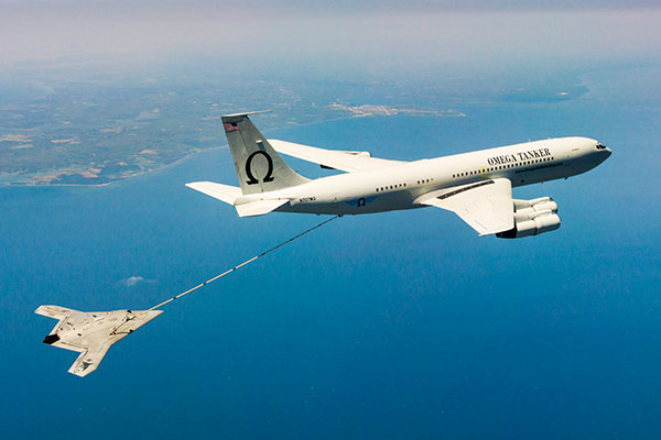
The X-47B unmanned combat aircraft receives fuel from an Omega K-707 tanker on April 22 while operating in the Atlantic Test Ranges over the Chesapeake Bay. This test marked the first time an unmanned aircraft refueled in flight. The X-47B is a tailless, jet-powered, blended-wing-body aircraft capable of semi-autonomous operation and aerial refueling.
STOIC Technology to Augment or Substitute for GPS
The Defense Advanced Research Projects Agency (DARPA) selected Rockwell Collins to develop technologies that could serve as a backup to GPS. The research, being conducted as part of DARPA’s Spatial, Temporal and Orientation Information in Contested Environments (STOIC) program, aims to reduce warfighter dependence on GPS for modern military operations.
Rockwell Collins will develop new architectures and techniques to enable communication systems that will support time transfer and positioning between moving platforms independent of GPS, with no impact on primary communications functionality.
“STOIC technology could augment GPS, or it may act as a substitute for GPS in contested environments where GPS is degraded or denied,” said John Borghese, vice president of the Rockwell Collins Advanced Technology Center. “The time-transfer and ranging capabilities we are developing seek to enable distributed platforms to cooperatively locate targets, employ jamming in a surgical fashion, and serve as a backup to GPS for relative navigation.”
Borghese added that the goal of the STOIC program is to develop positioning, navigation and timing (PNT) systems that provide GPS-independent PNT, achieving timing that surpasses GPS levels of performance. The program is comprised of three primary elements that, when integrated, have the potential to provide global PNT independent of GPS, including long-range robust reference signals, ultra-stable tactical clocks, and multifunctional systems that provide PNT information among cooperative users in contested environments.
For this third technical element, Rockwell Collins is tasked with developing multifunction communication system solutions that yield DARPA STOIC objective picosecond-accurate time transfer and enable GPS levels of relative positioning accuracy in contested environments.
“Future applications of STOIC technology could include a variety of precision relative navigation operations, such as autonomous aerial refueling and cooperative navigation and collision avoidance within unmanned aerial vehicle swarms,” Borghese said. “It also could support precise time transfer for networking operations in contested environments.”
ELORAN
Wildwood eLoran Tests Continue
The Wildwood, N.J.,eLoran 100-kHz transmitter continuously broadcast a signal from 0900 (EDT) on Oct. 20 through 1800 on Oct. 22, with plans to transmit further eLoran test signals from 0900 (EST) on Nov. 3 until 1200 on Nov. 6, and again from 0900 on Nov. 9 until1500 on Nov. 13.
The purpose of these tests is to gather data on differential Loran performance in the Boston Metro and D.C. Metro areas. “Besides fixed eLoran receivers at our N. Billerica, Mass., and Leesburg, Va., offices, we also have additional fixed eLoran receivers located at the USNO and at the Harris Corporation offices in Herndon, Va.,” stated UrsaNav. The company also plans to gather temporal and spatial decorrelation data in both Metro areas. Note that these signals are for test purposes only and should not be used for any other purpose.
In May, Exelis, UrsaNav, the Department of Homeland Security’s Science and Technology Directorate (DHS S&T) and the U.S. Coast Guard entered into a cooperative research and development agreement (CRADA) for testing and demonstration at former Loran-C sites, including Wildwood. The team will evaluate eLoran as a potential complementary system to GPS.
The sites are the legacy ground-based radio navigation infrastructure of the decommissioned Loran-C service that could be retained and upgraded to provide eLoran low-frequency service.The broadcasts will provide a usable signal at a range up to 1,000 miles.
INERTIAL
MEMS Perspective on SatNav Gathering
By Alissa M. Fitzgerald
In September, I attended the Institute of Navigation GNSS+ 2015 conference, where I chaired a technical session on commercial
micro-electro-mechanical sensors (MEMS). As the founder of a MEMS product development firm, I was eager to gain perspective from the world’s largest technical meeting and showcase of satnav technology, products and services.
Overall, the navigation community is enthusiastic about integrating MEMS into navigation systems. They like the idea of getting more data from small, relatively low-cost sensors. Recently, U.S. Secretary of Defense Ashton Carter declared his wish that we move to MEMS-based position, navigation and timing (PNT) information.
What navigators want from MEMS depends on who they are.
The “high integrity” navigators — the people whose systems land airplanes or steer self-driving cars — would like MEMS sensors with enough performance to enable accurate inertial navigation without GPS for at least 10 minutes. If a GPS receiver can’t see at least four satellites in the sky, it can’t produce accurate navigation data. High integrity navigators are the original developers of sensor fusion systems; they know that no one sensor is perfect, so they design systems to detect loss of a reliable signal, and then adeptly switch between sensor data streams as needed to maintain accurate navigation information. Ten minutes of GPS-independent inertial navigation buys you enough time to get to higher altitudes, out of a tunnel or around a skyscraper, to a position that improves your view of the sky.
The “consumer” navigators — the people who want you to help them find the nearest Starbucks in downtown San Francisco — would like better low-cost MEMS gyroscopes and magnetometers, specifically with improved stability, to improve pedestrian inertial navigation. Although pedestrians are relatively slow-moving compared to vehicles, a key challenge to their accurate navigation is maintaining inertial position fixes while their smartphones unexpectedly change orientation: waving about in a person’s hand or sliding around in a purse or pants pocket.
It’s clear we MEMS people need to spend more time with these end-users, to first understand how MEMS will integrate with their other sensors and GNSS, and then to derive the essential MEMS sensor specifications for each specific navigation system and use case. The quest for seamless navigation has been and will continue to be an exercise in sensor fusion.
Alissa Fitzgerald is managing member, A.M. Fitzgerald & Associates, a MEMS consulting firm serving diverse industries.
During the first week in September, Rockwell Collins completed Contractor Test and Evaluation flights at Eglin Air Force Base, Fla., for the Common Range Integrated Instrumentation System (CRIIS). The demonstration included ground-to-air uplink of GPS correction messages and network services from multiple data-link towers.
In cooperation with the CRIIS System Program Office (SPO), contractors and the University of Iowa Operator Performance Laboratory (OPL), 13 test flights were conducted using an L-29 from the University of Iowa OPL. Throughout the testing, the high reliability of the CRIIS equipment resulted in all test flights being performed as scheduled. Only a single test flight was scrubbed due to bad weather. All the flights were conducted using production form, fit, function airborne and ground equipment.
The CRIIS program fulfills critical Department of Defense (DoD) requirements to provide Time, Space, Position Information (TSPI) and additional platform test data, while employing a more robust, spectrally efficient data link, including Multiple Independent Levels of Security (MILS). The MILS encryption recently completed certification on the program, and is capable of simultaneously protecting four levels of Top Secret through Unclassified data flowing between aircraft and ground components.
“These flight tests demonstrate the mature, production ready level that the CRIIS program has reached,” said Tommy Dodson, vice president and general manager of Surface Solutions for Rockwell Collins. “Tests were an end-to-end validation of the complete CRIIS system using production representative hardware and software. This testing validated that the next generation of secure, common test and training instrumentation is mature.”
Rockwell Collins is the prime contractor and systems integrator for the next-generation military test range system that will replace the Advanced Range Data System (ARDS) currently in use at major U.S. military test ranges. CRIIS equipment will support a variety of platforms, including advanced fifth-generation aircraft, and implements the DoD’s vision of common test and training infrastructure for improved operational realism.
The following key functions were demonstrated on these flights:
End-to-end system validation with production representative hardware
High confidence in ability to meet TSPI performance requirements
Data-link network ingress after takeoff
Ground-to-air uplink of GPS correction messages and network services from multiple data-link towers
Air-to-ground downlink of TSPI messages
High dynamic scenarios involving a total of 133 dynamic maneuvers representative of flight profiles fighter jets undertake during air combat training
In addition to the multi-level secure ground equipment, the CRIIS flight hardware is configurable in either a pod mounted package or internally mounted on aircraft. This gives CRIIS the flexibility to adapt to use by a wide range of aircraft from all over the world, and the ability to fully integrate those aircraft into complex training scenarios.
Following the completion of CT&E, the CRIIS SPO will conduct Government Test and Evaluation (GT&E) later this year to support a planned final Production Readiness Review in the near future.
Rockwell Collins has been selected by the Defense Advanced Research Projects Agency (DARPA) to develop technologies that could serve as a backup to GPS. The research, being conducted as part of DARPA’s Spatial, Temporal and Orientation Information in Contested Environments (STOIC) program, aims to reduce warfighter dependence on GPS for modern military operations.
Under the terms of the agreement, Rockwell Collins will develop innovative architectures and techniques to enable communication systems that will support time transfer and positioning between moving platforms independent of GPS, with no impact on primary communications functionality.
“STOIC technology could augment GPS, or it may act as a substitute for GPS in contested environments where GPS is degraded or denied,” said John Borghese, vice president of the Rockwell Collins Advanced Technology Center. “The time-transfer and ranging capabilities we are developing seek to enable distributed platforms to cooperatively locate targets, employ jamming in a surgical fashion, and serve as a backup to GPS for relative navigation.”
Borghese added that the goal of the STOIC program is to develop positioning, navigation, and timing (PNT) systems that provide GPS-independent PNT, achieving timing that far surpasses GPS levels of performance. The program is comprised of three primary elements that, when integrated, have the potential to provide global PNT independent of GPS, including long-range robust reference signals, ultra-stable tactical clocks, and multifunctional systems that provide PNT information between cooperative users in contested environments.
For this third technical element, Rockwell Collins is tasked with developing multifunction communication system solutions that yield DARPA STOIC objective picosecond-accurate time transfer and enable GPS-levels of relative positioning accuracy in contested environments.
“Future applications of STOIC technology could include a variety of precision relative navigation operations, such as autonomous aerial refueling and cooperative navigation and collision avoidance within unmanned aerial vehicle swarms,” said Borghese. “It also could support precise time transfer for networking operations in contested environments.”
The first Gen III F-35 Helmet Mounted Display System has been delivered. (Photo: Rockwell Collins)
Lockheed Martin and Rockwell Collins have delivered the first Gen III F-35 Helmet Mounted Display System (HMDS). The advanced technology for warfighters provides pilots with unprecedented levels of situational awareness and allows them to “look through” the airframe.
Company executives commemorated the delivery of the first HDMS on Aug. 11 with Sen. Joni Ernst in Cedar Rapids, Iowa. In addition to the HMDS, the Lockheed Martin F-35 Lightning II demonstrator was on site at the Cedar Rapids headquarters of Rockwell Collins for Sen. Ernst to get a first-hand experience of “flying” the military’s most advanced fighter jet following the delivery ceremony.
Rockwell Collins, through its joint venture, Rockwell Collins ESA Vision Systems LLC, is providing the most advanced technology for warfighters with the F-35 HMDS, which provides pilots with unprecedented levels of situational awareness and allows them to “look through” the airframe.
The Gen III helmet, which includes an improved night vision camera, improved liquid-crystal displays, automated alignment and software improvements is to be introduced to the fleet in low rate initial production Lot 7 in 2016. Rockwell Collins ESA Vision Systems LLC also developed the Gen II helmet that F-35 pilots currently use, which met the needs for the U.S. Marine Corps and will allow the service to declare Initial Operational Capability.
All the information that pilots need to complete their missions — through all weather, day or night — is projected on the helmet’s visor. Additionally, the F-35’s Distributed Aperture System (DAS), made by Northrop Grumman, streams real-time imagery from six infrared cameras mounted around the aircraft to the helmet, allowing pilots to “look through” the airframe.
“Today’s visit was an opportunity to place focus on Rockwell Collins, as manufacturing makes up such an important part of our economy here in Iowa,” said Senator Ernst. “Having served in the military for over 20 years, I appreciate the company’s efforts in support of our national defense, our armed forces and our veterans.”
“We’re pleased to be able to demonstrate the advanced capabilities of the F-35 Lightning II at Rockwell Collins today to Sen. Ernst and members of the Cedar Rapids community,” said Steve Callaghan, director, F-35 Program, Lockheed Martin Washington Operations. “The employees at Rockwell Collins are contributing to the F-35s flying today, and we’re pleased to have the opportunity to showcase the superior performance capabilities of this aircraft with them.”
Overall, Rockwell Collins has built and fit more than 200 helmets for F-35 pilots who are being trained for the program.