The high-accuracy service (HAS) offered by Galileo is now available and provides sub-meter accuracy over most of the globe. It will help enable emerging technologies such as UAVs and autonomous vehicles, which require stringent levels of accuracy for better navigation, safety and efficient traffic management.
Other industries expected to benefit include transportation, agriculture, geodesy and entertainment.
Thierry Breton, European commissioner for Internal Market, announced that the service was now live during the annual European Space Conference in Brussels, Belgium, on Jan. 24.
The European Union Agency for the Space Programme (EUSPA) developed Galileo HAS along with the European Commission and the European Space Agency (ESA). The new service will become a pillar of government programs such as EU sectorial policies and national policies by EU Member States.
“This new service has been made possible thanks to the outstanding cooperation and team commitment of all involved partners,” said Rodrigo da Costa, EUSPA executive director.
“Galileo is not standing still,” said Javier Benedicto, ESA director of navigation. “This new High Accuracy Service offers a new dimension of precision to everyone who needs it, while the Open Service Navigation Message Authentication — already available — allows users to authenticate Galileo signals as they make use of it, to minimize any risk of spoofing. An upgraded integrity message of the signal rolled out last year reduces the time to first fix while enhancing the overall robustness of Galileo.”
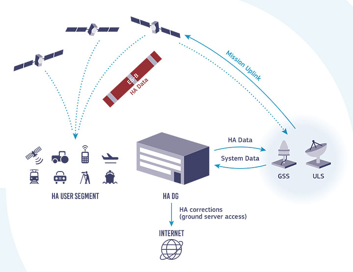
Galileo HAS delivers horizontal accuracy down to 20 cm and vertical accuracy of 40 cm in nominal use conditions, according to ESA. The service is transmitted directly via the Galileo signal in space (E6-B) and through the internet.
With HAS, Galileo becomes the first constellation worldwide able to provide a high-accuracy service globally and directly through the signal in space.
The service is freely accessible to all users with a receiver capable of processing the HAS corrections broadcast in the E6-B signal and via the internet. The precise corrections provided by Galileo HAS will allow users to reduce the error associated with the orbit and clocks provided through the Galileo Open Service broadcast navigation messages and the GPS Standard Positioning Service navigation data.
“With the Galileo HAS we are ready to unleash the full potential of new technologies such as drones and bring autonomous driving closer to reality,’’ da Costa said. “At EUSPA, our role is to link space to user needs. With the launch of this new service, we met a clear market demand for accurate, robust, and reliable navigation.”
As PNT becomes critical to more economic activities, any disruption in availability, reliability, resilience and integrity would weaken the critical infrastructure that sustains national security, business operations and public safety, according to experts speaking at the Geospatial World Forum.
This growing dependency on PNT services — and the potentially high economic cost of vulnerabilities — underscores how vital GPS and GNSS systems are to the global economy and national security of countries worldwide, the experts said. Resilient PNT systems are necessary to combat GPS/GNSS outages.
Robert Cardillo (Photo: GWF)
Building resilience into these systems will require multiple technologies ranging from network time-transfer services to terrestrial wireless infrastructure and low-Earth-orbit (LEO) satellites.
The Geospatial World Forum opened in Amsterdam on May 10. The second plenary of the day focused on the value of PNT in the global economy. Geospatial World is a global think tank working towards raising awareness around the use of geospatial data and technologies among governments and policymakers, businesses, and the public at large.
Robert Cardillo, president of The Cardillo Group and former director of the U.S. National Geospatial Intelligence Agency (NGA), headed the panel of experts.
“Our existence on this planet has been shaped by our individual and collective awareness of place and our confidence to be able to move securely and efficiently from one place to another, all within that common framework of position, navigation and timing, or PNT,” he said.
“The smartphone is a wonderful example of how far PNT has been integrated into our lives,” said Trimble founder Charlie Trimble. He laid down three basic phases involved in leading PNT to its place in the world economy.
“The path from the dawn of space age to the smartphone was anything but obvious or straightforward,” Trimble said. “First, Sputnik led to the global navigation systems. Second, the Shuttle disaster led us to the realization that the satellite system was an information utility. And now, the integration of PNT into the mobile and immobile internet is changing our world.”
From left: Charlie Trimble, Martin Sweeting, Rodrigo da Costa and Gillian Smith. (Photo: GWF)
“Our first contract was with ESA (European Space Agency) to look at the feasibility of using a navigation and timing satellite using small-satellite techniques, which in 1985 was considered a wacky idea,” recounted Martin Sweeting, executive chairman of Surrey Satellite Technology Ltd. “At ESA, we have embarked on a project called Hydro GNSS, which uses Surrey’s GNSS reflectometry to address several climate related issues, be it water detection or biomass, etc. This doesn’t stop here; we are looking at the lunar economy. PNT has indeed a very bright future, not just on Earth but also looking through this decade into the use of PNT on the lunar surface.”
Rodrigo da Costa
“New things are happening, particularly in the area of governmental satellite communications, space situational awareness and others, which are benefitting citizens every day,” said Rodrigo da Costa, executive director, EU Agency for the Space Programme (EUSPA). “Galileo, EGNOS (European Geostationary Navigation Overlay Service), Copernicus and GOVSATCOM programs are key areas of EU space activities. All these programs are massive investments and in the end, the result comes from their utilization in the different areas of our economy and daily life.”
“Just in the United States alone, GPS is approaching USD 1 trillion in terms of economic impact and is doubling every 2-3 years. But it is a single point of failure. This highlights the need for resilient PNT,” said Gillian Smith, vice president of marketing, NextNav. “We believe that our needs have evolved beyond technology that was really created in the ’60s. We need increased accuracy and availability in the urban environments in particular.
“I think many of you have experienced it if you’ve tried to use it in any major city,” Smith said. “That blue dot is going to bounce off of buildings and not be very accurate. We need indoor tracking and mapping. We need altitude data so that you know what floor you’re on when you’re thinking about accurate location. We also need to increase resilience and redundancy. That’s going to give us all increased security as well.”
The Value of GPS
GPS jamming and interference is a grave issue that has come under the spotlight particularly since the Russian invasion of Ukraine, according to Geospatial World.
In 2019, a Washington, D.C., think tank documented more than 10,000 cases of GPS interference (jamming and spoofing) in the previous five years from Russia. By 2021, these had become increasingly sophisticated. In a peculiar case, the crew onboard NATO ships in Odessa saw their position being given as Crimea.
In the past six months, even before the war on Ukraine began, there were reports of GPS jamming in and around that region. In March, the EU Aviation Safety Agency had issued warnings of GNSS spoofing and jamming for flights over Europe, in particular around countries neighboring Ukraine and Russia.
Globally, the economic impact of GPS/GNSS disruption is difficult to state. The potential economic consequences of failing to sufficiently protect sources of PNT are enormous, with estimates ranging from millions to billions of dollars depending on the type, length, severity and geographic scope of the disruption.
Furthermore, the impact of a GPS/GNSS outage extends beyond basic economics and could result in risk to life. Emergency services, distress beacons and telecommunications networks all rely on PNT services — any disruption could cause serious consequences.
A 2019 report sponsored by the National Institute of Standards and Technology estimated that the loss of GPS would cost the U.S. economy USD 1 billion a day.
A 2017 study in the United Kingdom estimated a five-day GNSS disruption would lead to an economic impact of GBP 5.2 billion (USD 7.2 billion), with road, maritime and emergency service impacts accounting for 88 percent of the cost.
A new space agency launched in Europe today, taking the place of the European GNSS Agency (GSA) and adding responsibilities to encourage Europe’s space enterprises.
The European Union Agency for the Space Program (EUSPA) marks the start of a new era for European Union space, according to an agency statement. EUSPA will build on the legacy of the GSA, which was established to promote use of Galileo and EGNOS, with additional responsibilities to create even more opportunities from space for European Union citizens and its economy.
An April 27 space regulation established EUSPA. Under the new space regulation, EUSPA’s mandate includes promoting Galileo and EGNOS, but with increased responsibilities, including their service provision and operational security. The agency also will coordinate the user-related aspects of government satellite communication in close collaboration with Member States and other entities.
Including Copernicus
Rodrigo da Costa, executive director, EUSPA (Photo: EUSPA)
EUSPA is also responsible for the development of downstream markets and fostering of innovation based on Galileo, EGNOS, and now also commercial uses of Copernicus (Europe’s Earth observation satellite program), leveraging funding mechanisms such as Fundamental Elements and Horizon Europe.
EUSPA is also responsible for security accreditation of all the components of the EU Space Program. The European Commission may also decide to entrust the agency with other tasks.
“More and more, our economies, our society and our safety depend on space,” said EUSPA Executive Director Rodrigo da Costa, former director of GSA. “Europe has incredible opportunities ahead that cannot be missed. By creating EUSPA, the European Union will further increase the return on investment made by EU citizens in the EU Space Program by strengthening its contribution to the priorities of the union. We will achieve this primarily by leveraging synergies between the various program components — particularly navigation, Earth observation and secure communications — to drive innovation across a broad range of sectors.”
In particular, bringing management of downstream and combined applications based on Galileo, EGNOS and Copernicus under the umbrella of one agency will make it possible to leverage synergies, according to the agency statement. “On their own, these technologies can play a key role supporting a digital and green transformation, but leveraging their synergetic and combined use will facilitate the generation of innovative solutions that bring a higher societal impact,” the statement read.
Focus on security
“The teams of committed professionals we have in place at our sites in Europe — from the EGNOS center in Toulouse to the European GNSS Service Centre in Spain and the Galileo Reference Centre in the Netherlands — will continue to ensure the high quality, robustness and reliability of EUSPA’s service provision,” reads the statement. “This will be backed up Galileo security monitoring centers in France and in Spain, and the industrial teams managed by EUSPA in the Galileo control centers in Germany and Italy, along with facilities around the world.”
In addition, the Security Accreditation Board will continue to initiate and monitor implementation of security requirements to ensure a robust and uniform level of security for the entire EU Space Program.
“The new agency has a core role in the security accreditation of all the components of the EU Space Program,” said Bruno Vermeire, chair of EUSPA’s Security Accreditation Board.
Looking to the future
While EUSPA’s mission has expanded, its core aim remains the same – to link EU investment in space to the needs of users in the European Union and around the world.
“The agency remains committed to its traditional users and will continue to deliver the high level of GNSS services that users have come to rely on,” the agency stated. Copernicus and satellite communications will also benefit from the former GSA’s user-oriented focus and “the experience it has gained in developing markets for Galileo and EGNOS.”
Fucino, Italy, hosts a Galileo Control Centre. (Image: Telespazio/ESA)
The European GNSS Agency (GSA), with the European Commission, has published an information note on the Galileo High Accuracy Service (HAS). The 16-page document provides an overview of the main characteristics of the service, information on features such as service levels, target performance, an implementation roadmap, and an overview of the target markets for the service.
Target markets for Galileo HAS include geomatics, precision agriculture, consumer solutions and the space sector.
The market for high-accuracy positioning is dynamic, driven by various factors, including
emerging applications such as autonomous vehicles and drones;
technological advances such as dual-frequency chipsets for the mass-market; and
the market situation, with cheap or free-of-charge augmentation services available in some countries.
These factors are resulting in the democratization of high accuracy, which is becoming a more widespread commodity, rather than the exclusive domain of professional applications.
With the Galileo HAS, Galileo will pioneer a worldwide, free high-accuracy positioning service aimed at applications that require higher performance than that offered by the Galileo Open Service.
Benefitting several markets
Target markets for the HAS include geomatics, agriculture or consumer solutions. Transport is also a major potential target market, with possible applications in aviation, road, rail and maritime and inland waterways.
In these markets, the HAS will provide high-accuracy precise point positioning corrections for Galileo and GPS free of charge, in the Galileo E6-B data component and by terrestrial means, to achieve real-time improved user positioning performances, with a positioning error of less than two decimetres in nominal conditions.
“With its High Accuracy Service, Galileo will be the first satellite constellation able to provide a high-accuracy precise point positioning service globally, directly through the Signal in Space,” said GSA Executive Director Rodrigo da Costa. “This will be another key differentiator of the Galileo system, giving it a competitive advantage over other systems and allowing it to foster innovation in both consolidated and emerging markets.”
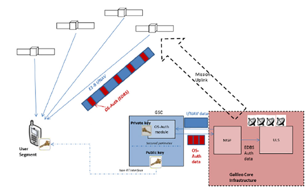
Galileo HAS high-level architecture. (Image: GSA)
HAS Initial Service
HAS Phase 1 will cover the provision of an initial Galileo HAS resulting from the implementation of a high-accuracy data-generation system that processes Galileo data only.
Phase 2 will see full provision of the Galileo HAS, meeting its target performance of 20-cm worldwide positioning accuracy after 2024.
Through the HAS, Galileo will offer a unique service with the transmission of corrections directly via Galileo satellites, allowing free high-accuracy positioning globally, for everyone.
In a first for any satellite navigation system, Galileo has achieved the first position fix based on navigation signals carrying authenticated data, according to the European Space Agency.
Galileo’s Open Service Navigation Message Authentication (OSNMA) is intended as a way to combat malicious spoofing of satnav signals.
OSNMA receivers successfully calculated an OSNMA-protected position fix after Galileo satellites started transmitting authentication data at 15:28 UTC on Nov. 18, 2020. The first tests used eight Galileo satellites for around two hours on Nov. 18. Tests have continued ever since, for intermittent periods, and will continue over the next months ahead of a public observation phase.
The first authenticated signal position, velocity and timing fixes were made using a total of eight Galileo satellites for around two hours on Nov. 18, 2020. The tests represent a first proof-of-concept for an eventual operational service offering positioning with authenticated data to users. (Image: ESA)
Pioneering a long-awaited service
The Galileo OSNMA authentication mechanism allows GNSS receivers to verify Galileo information, making sure that received data are indeed from Galileo and not modified in any way.
“Ensuring the validity of positions elaborated by GNSS is one of the main challenges before addressing an entirely new set of applications demanding dependability and resilience,” said Matthias Petschke, director of space at the European Commission, DG DEFIS. “Galileo is now set on course to deliver on this highly anticipated feature and has many more novel features in store for the coming years.”
Testing is taking place at ESA’s Navigation Laboratory at ESTEC in the Netherlands, the same site where the first Galileo positioning fix took place in 2013.(Photo: ESA)
Increased robustness
OSNMA test signals are being broadcast by the Galileo constellation using the spare bits from the current navigation message, therefore not impacting the legacy OS receivers implementing the current OS Signal-In-Space Interface Control Document (OS SIS ICD).
“Galileo’s Open Service Navigation Message Authentication is one of its key differentiators,” said Rodrigo da Costa, executive director of the European GNSS Agency. “The additional robustness that it will provide to the Galileo signal will be critical for many applications, particularly those where security and trustworthiness are a priority, making the OSNMA a key component in any resilient PNT solution.”
OSNMA works on a comparable basis to everyday encryption, where sending a digitally signed document involves both sender and recipient using compatible cryptographic keys (private and public) to validate the document’s source of origin.
“Up until now, as a navigation satellite disseminates navigation and timing data, there is no way of confirming these data are indeed coming from their apparent originator,” explained Paul Verhoef, director of navigation at the European Space Agency. “As a result, the data could be falsified, a phenomenon known as spoofing, where corrupt false signals mislead receivers about their position, misleading their users in turn, with potentially serious consequences.”
An ESA Navigation Directorate team at the ESTEC technical centre in the Netherlands worked with their European GNSS Agency (GSA) counterparts at the twin Galileo Control Centres in Italy and Germany and the Galileo Service Centre (GSC) in Spain to develop and test the OSNMA.
Next steps
Upon successful completion of the internal testing phase, a public observation phase will begin, in which the OSNMA signal will be publicly accessible. In preparation for this phase, the OSNMA user Signal-In-Space Interface Control Document (OSNMA SIS ICD), receiver implementation guidelines, and the necessary cryptographic materials will be published. This will allow receiver manufacturers and application developers to test and prepare their products.
During the public observation phase, feedback will be gathered from users, leading to the consolidation of the service.
Testbed vehicle by ESA’s Navigation Lab. (Photo: ESA)
Authors Javier Benedicto (ESA), left, and Rodrigo da Costa (GSA). (Image: ESA)
Throughout 2020, the Galileo Programme under the responsibility of the European Commission, the European GNSS Agency (GSA) and the European Space Agency (ESA), has been delivering continuous and reliable global PNT and Search and Rescue (SAR) services, developed improvements to Galileo First Generation ground and space system infrastructure for increased robustness and new service capabilities, and launched a full modernization program aiming in the future at Galileo Second Generation.
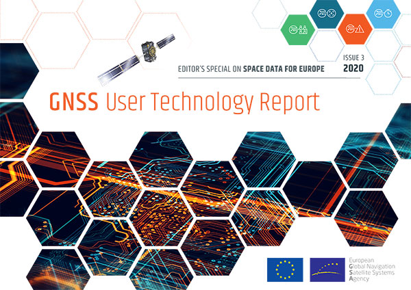
The GNSS User Technology Report 2020 has just been released by GSA, providing a complete overview of the current status and trends of the GNSS worldwide market with focus on user technology and in particular European GNSS (Galileo and EGNOS) applications and services.
In addition to providing a high quality open service based on innovative signals in the E1 and E5 bands, Galileo is also the first GNSS constellation to comprise a SAR capability, including the provision of a return link to users in distress. Galileo also features unique capabilities, such as the provision of Navigation Message Authentication (OS-NMA) and of an encrypted navigation signal on E6, the Commercial Authentication Service (CAS). These functions will offer the first protection against spoofing available to civilian GNSS users.
Finally, Galileo will provide free access to a High Accuracy Service (HAS) through the use of an open data channel used to broadcast high-accuracy augmentation messages.
Performance Meeting Expectations
The Galileo constellation consists today of 22 operational spacecraft (24 satellites are available for the Search and Rescue service). Two additional satellites (GSAT0201/E18 and GSAT0202/E14) are currently under testing with regard to potential operational as auxiliary usage in the near future.
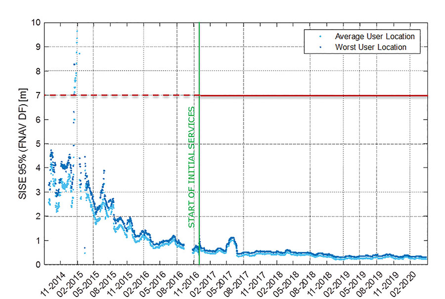
The long-term evolution of performance parameters reveals that the Galileo system is continuously improving. In particular, an excellent quality of the navigation message in terms of ranging accuracy can be observed. Since the Initial Service declaration in 2016, ranging accuracy has steadily improved reaching a level of ~25 cm (95%) by mid of 2020, see Figure 1.
FIGURE 1. F/NAV SISE as observed by user receivers (constellation average, 30 days moving average). (Image: ESA)
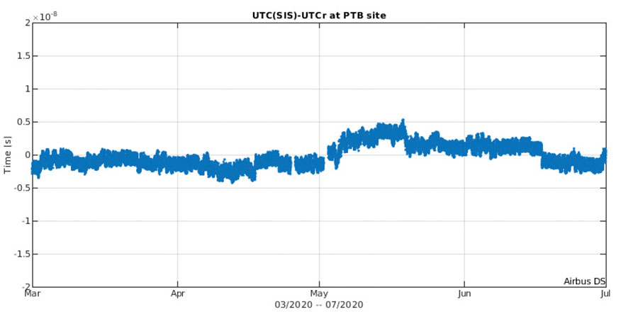
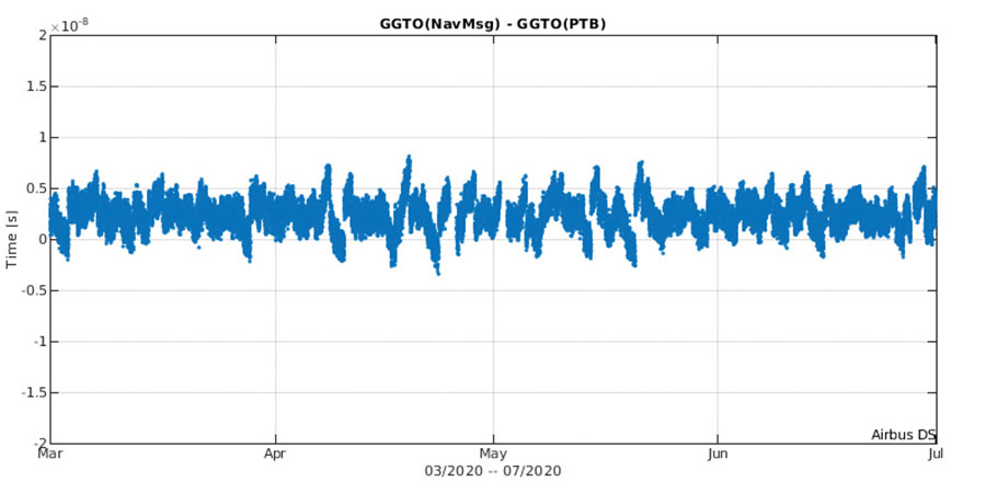
The timing accuracy benefits from the larger number of satellites in service. Figures 2 and 3 present the evolution of the UTC dissemination accuracy and GGTO accuracy performance better than 2.5 nsec and 4.2 nsec (95%) respectively, which are largely within Galileo service commitments.
Probably the most significant discriminator of Galileo versus other GNSS is its capability to broadcast multi-frequency (E1, E6, E5) signal components on all operational satellites. In the high-end and mid-range smartphone chipset market, dual frequency is becoming the norm. All large players have released dual-frequency chipsets, and the first dual-frequency chipsets targeting the budget device market are now becoming available. Dual-frequency receivers offer improved accuracy and robustness, and potential access to high-accuracy techniques. Multi-constellation is now standard for high-volume chipsets and Galileo with its multi-frequency capability is one of the largest GNSS contributors to this emerging dual-frequency PNT market.
Expanding Galileo Services Portfolio
Galileo offers the Galileo Open service (OS) for positioning and timing services, and Europe’s Search and Rescue (SAR) service contribution to COSPAS-SARSAT, equipped with its unique Return Link Message (RLM) declared operational in January 2020. Furthermore, the Galileo system is expanding its infrastructure capabilities such that, once fully operational, it will offer additional high-performance services worldwide.
Public Regulated Service (PRS) is restricted to government-authorized users for sensitive applications that require a high level of service continuity.
Open Service INAV message improvements on Galileo E1-B are under implementation, namely robust symbol level synchronization patterns, additional insertion of clock and ephemeris data with flexible outer encoding and frequent provision of shortened clock and ephemeris for improved robustness in terms of navigation data retrieval in challenging environments, in addition to facilitating a reduced time to first six (TTFF); these improvements ensure backwards compatibility with previously released OS SIS ICDs.
Open Service Navigation Message Authentication (OS-NMA) providing the free authentication of the Galileo Open Service (OS) for geolocation information through the Navigation Message (I/NAV) broadcast on the E1-B signal component.
Commercial Authentication Service (CAS), complementing the OS, providing a ranging authentication function implemented by encrypting the spreading code of the E6C (pilot) channel with a secret key. To ensure backward compatibility, CAS is based on the only civilian signal including cryptographic features (E6). When using both OS-NMA and CAS, users will benefit from data (navigation message) and range authentication, allowing PVT authentication worldwide.
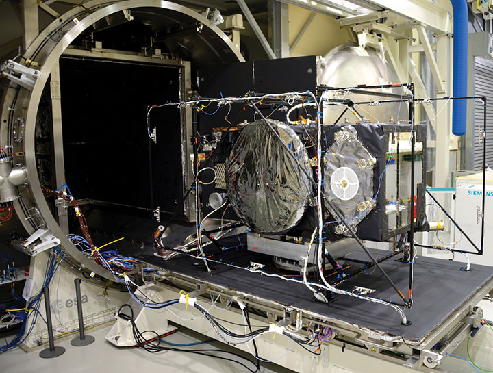
Galileo Batch 3 satellite under test at ESA’s ESTEC facility in the Netherlands. (Photo: ESA)
High Accuracy Service (HAS) complementing the OS by delivering free access high accuracy data and providing better ranging accuracy, enabling users to achieve sub-meter level positioning accuracy.
Support to Safety of Life (SoL) Services through Dual Frequency Multi-Constellation (DFMC) SBAS and supporting the provision of integrity through the concept of Horizontal Advanced Receiver Autonomous Integrity Monitoring (H-ARAIM). In this context, the Galileo Integrity Failure Mode and Effect Analysis (IFMEA) Process is implemented through measurements and review of the system design, including characterization of feared events.
Galileo Batch 3 satellite under test at ESA’s ESTEC facility in the Netherlands. (Photo: ESA)
Infrastructure Modernization
The Galileo System infrastructure is being upgraded and modernized to support the full service portfolio, provide additional robustness and resilience, ensure security and improve operations.
The Galileo Ground Segment is being upgraded implementing ground segment virtualization technologies. This modernized infrastructure will make it possible to easily accommodate technology refresh and will minimize impact to Galileo service operations, under the responsibility of Spaceopal GmbH, during future deployment activities.
Current ground segment upgrades under production by prime contractor Thales Alenia Space in France (in charge of Ground Mission Segment and Security Monitoring) are addressing the deployment of improved robustness of the navigation and precise timing solutions, the full scope of PRS service capabilities, the expansion of the sensor station and up-link ground station networks, and additional security monitoring coverage to protect Galileo ground and space assets.
Ground segment upgrades under production by prime contractor GMV in Spain are addressing the deployment of a new Ground Control Segment providing increased constellation monitoring and control capabilities up to 38 satellites, enhanced operability features, expansion of the TTC network and additional security protection capabilities.
Upgrades of the Galileo Service Facilities are underway as well, notably the evolution of the GNSS Service Center toward the integration of the OS-NMA and HAS capabilities, and the extension of the reference measurement capabilities of the Galileo Reference Centre, by the prime contractor GMV in Spain. The robustness of the SAR service operations, under the prime contractor CNES in France, is also under improvement.
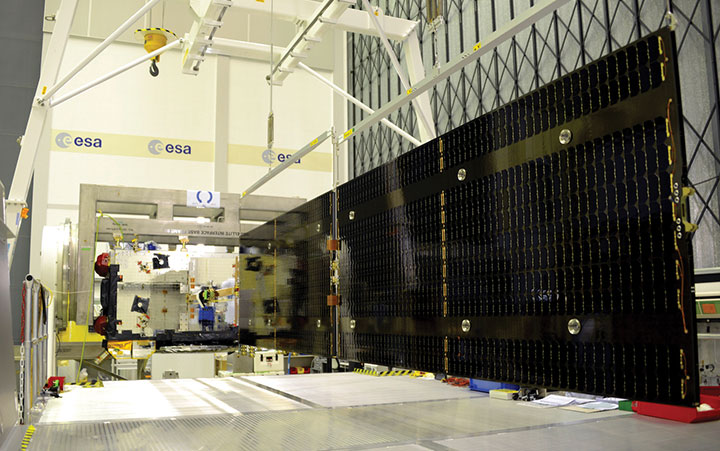
The production of 12 additional Batch 3 Galileo first generation satellites is proceeding, aiming at readiness for launch from mid 2021 onward. Batch 3 satellites are comparable to the 22 FOC satellites launched previously and built by the same prime contractor OHB Systems in Germany. With Batch 3 satellites, Galileo will reach its full constellation capability, including a number of in-orbit spares.
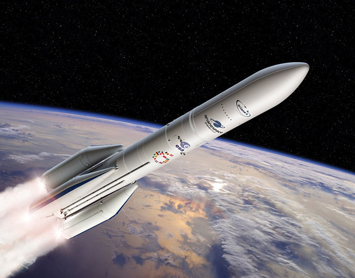
Galileo Batch 3 satellites will be progressively launched with the new Ariane 62 launcher vehicle, the two strap-on solid booster variant of Ariane 6, currently undergoing the final stages of development led by prime contractor ArianeGroup. Meanwhile, France’s space agency CNES is preparing the Ariane 6 launch facilities at Europe’s Spaceport in French Guiana. Ariane 6 is scheduled for its first launch in 2022.
Europe’s new Ariane 6 launch vehicle. (Artist’s concept: ESA)
Toward Galileo Second Generation
The Galileo Programme is fully engaged in the process of developing Galileo 2nd Generation (G2G). Procurement activities for system, satellite and ground segment have been initiated in 2020 with the ambitious goal of starting deployment of the new infrastructure in 2024.
The design of G2G is driven by overarching principles, including backward compatibility, providing an extended portfolio of services and the quality of services, but also the absolute need to meet user demands in a timely and effective manner. The European Commission, in close consultation with EU member states, has converged onto an ambitious set of long term PNT goals for the future European GNSS infrastructures.
G2G Service Portfolio and High-Level Mission Objectives agreed with Programme Stakeholders Service include service evolutions in the areas of signals evolution for increased performance and reduced complexity and power consumption at the user receiver level, time to first-fix, accuracy, authentication and other service attributes, PRS evolutions, advanced timing services, enhanced integration with terrestrial systems (5G/6G), complementarity with external sensors (such as INS, barometer, lidar) and application environments (such as low power devices and internet of things), SAR service evolution, Emergency Warning services, Space Service Volume and Ionosphere Prediction Service.
G2G will build on advanced navigation technology developed over the past 10 years under ESA’s European GNSS Evolution Programme (EGEP) and EU’s Horizon 2020 Programme. This technological leap will allow the early introduction of novel Galileo system features:
Open service capabilities (reduce power consumption and convergence time)
High-accuracy evolution (integrity, availability)
PRS robustness and transmit power
System and SIS in-orbit flexibility, reconfiguration and time-to-market
Inter-satellite links (ranging, mission dissemination, command and control)
SAR second-generation beacons
Reduce operations and maintenance cost
Accelerate time-to-market of new services
Ground technology virtualization and modernization
Acknowledging the changing nature of user requirements, the Galileo second-generation is designed to evolve incrementally and with sufficient flexibility to provide new services or signal features, if and when required, by dynamic reconfiguration of space and ground infrastructure.
The full GNSS User Technology Report 2020 is available for download. (Cover: GSA)
News from the European GNSS Agency
The European GNSS Agency (GSA) has released its latest GNSS User Technology Report, providing a comprehensive analysis of GNSS trends and developments.
With four GNSS available and more than 100 satellites in operation broadcasting multiple frequencies, the GNSS industry is shifting towards the wide adoption of multifrequency receivers across market segments to meet the diverging user needs of emerging applications.
The report includes contributions from leading GNSS receiver, chipset manufacturers and service providers, and serves as a valuable tool to support planning and decision-making with regards to developing, purchasing and using GNSS technology.
Published biennially since 2016, the User Technology Report has become a point of reference for the GNSS industry, research and policy-makers.
Rapid Evolution
‘’The GNSS industry is evolving at a rapid pace and is shaped by the dynamics of emerging applications and user needs as well as the upgrade of existing and new GNSS and Satellite Based Augmentation Systems (SBAS),” said Rodrigo da Costa, GSA executive director. “The industry has understood the potential of Galileo’s unique features.”
The third edition of the report begins with a chapter devoted to technology trends common to all segments: receiver design, position processing and signal processing. It also discusses protection measures against GNSS jamming and spoofing, such as authentication, including what 5G and other technologies and sensors can do, in combination with GNSS.
With multi-constellation now being the norm, the industry is moving towards the wide adoption of multi-frequency receivers even for usually power- and cost-constrained consumer solutions. The Galileo E5 is becoming the preferred frequency with about 20% of all receiver models in the market already using it.
The report is built around four macro segments defined on the basis of commonalities from a technology point of view:
high volume
safety- and liability-critical
high-accuracy
timing devices and solutions (a new-entry in this edition)
Each chapter starts with the macrosegment characteristics and receiver capabilities, depicts the industry landscape and typical receiver form factor, it then delves into the key current and future drivers and trends, and finishes with the added value of the EGNSS, Galileo and EGNOS, for the macrosegment at stake.
Space Data for Europe
This year editor’s special “Space Data for Europe” sheds light on the role that Copernicus and Galileo play within the European Space Programme in the data management and use, now and in the future. It also provides a vision of major transformations underway within our society and our economy and the benefits expected from this digital transformation, paving the way towards the European Data Strategy and Green Deal.
“Today, Galileo and EGNOS already provide increased capabilities which are being used across a broad range of applications, and are already igniting the next generation of location-based applications. In the future, new services — the Galileo High Accuracy Service (HAS), Galileo Open Service Navigation Message Authentication (OS-NMA) and Commercial Augmentation Service (CAS) — will raise the accuracy and reliability bar even higher, and dramatically enhance positioning, navigation and timing solutions for businesses and citizens.
By bringing insight and understanding into the evolutions of GNSS technology, we are creating opportunities for innovation,” concluded da Costa.
On Oct. 16, Rodrigo da Costa took up his duties as executive director of the European GNSS Agency (GSA), soon to become the EU Space Programme Agency.
He was elected by the GSA Administrative Board on Sept. 15 and met with the ITRE Committee of the European Parliament on Oct. 12.
Da Costa, a Portuguese national who has worked in a number of EU countries, joined the GSA as the Galileo Services Programme manager in March 2017. In this position he was responsible for leading Galileo, the European Union GNSS, in its service provision phase.
He has previously held several senior project management, business development, and institutional account management positions in space industry, in the areas of human space flight, exploration, launchers and research and development.
Da Costa will now be working on transforming the GSA into the EU Space Programme Agency (EUSPA). He will ensure that its existing activities continue to be successfully delivered while also performing new ones required to undertake with the Agency’s new mandate.
Since its creation in 2004, the GSA has made an unparalleled contribution to the EU flagship satellite systems Galileo and EGNOS, which have significantly contributed to the union’s independence and economic growth.
Staffed with highly skilled and dedicated personnel, the agency has boosted innovation, fostered entrepreneurship, led the provision of services, and stimulated the EU economy, in particular through ensuring Galileo and EGNOS uptake across a wide range of market segments thanks to high-quality and secure satellite services.
Rodrigo da Costa, executive director of the European GNSS Agency. (Photo: GSA)
With eyes fixed on the future, EUSPA will further build on the work of the GSA, and will take on additional new responsibilities for further components to the EU Space Programme, including activities in Copernicus (the European Earth observation programme), GOVSATCOM (the EU secure satellite communication system).
Commenting on his new duties da Costa said: “Becoming Executive Director of the Agency means, above all, to lead a team of excellent, dedicated professionals. I’m immensely excited by the opportunity we have to build a successful EUSPA, a key contributor of the EU Space Programme. I’m looking forward to working with all our stakeholders. The task is vast, but I am confident we will be able to play our part, demonstrating to EU citizens what we can do together in EU space activities as GSA/EUSPA.’’