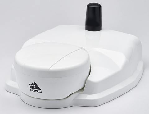
NovAtel’s SMART6-L attaches to the Relay RTK radio module to create a single unit for easy system integration.
NovAtel Inc. has launched the Relay RTK radio module, a docking station that provides radio connectivity for its SMART6-L L-band capable GNSS receiver.
The Relay RTK module combined with NovAtel’s SMART6-L receiver creates a compact, easy to integrate positioning solution, NovAtel said. It is available in four radio versions: 400 MHz UHF licensed band; 900 MHz UHF unlicensed band; HSPA (3G) cellular; and CDMA (1xRTT/EV-DO) cellular. The CDMA version is approved for use on the Verizon cellular network.
The 400 MHz and 900 MHz versions support both base and rover configurations. The base station is configured via the integrated web-server/Wi-Fi access point using the web browser on any compatible personal computer, tablet or smartphone. The cellular radio versions support the reception of NTRIP and RTK corrections over the cellular network.
SMART6-L customers can connect to the Relay using their existing SMART6-L interface cables. Relay has support for both screw and magnetic mounting; optional mounting plates are available for roof and pole mounting. NovAtel’s SMART6-L with Relay provides the same level of performance as a standalone SMART6-L unit with the added convenience of radio connectivity to support RTK and NTRIP corrections.
Saneamento Basico do Estado de São Paulo (SABESP), a Brazilian water and sewage collection utility owned by São Paulo state and Latin America’s largest water company by market capitalization, has selected Spectra Precision ProMark 120 and 220 GNSS receivers to assist in gathering the geographic location of all SABESP network assets and the location of all customers.
SABESP provides water to more than 28.7 million customers, or 67 percent of the population of São Paulo state. Water loss due to leakage in the SABESP network is a significant problem. The biggest reason behind water loss is leaks in the network; additional factors include sub-metering, caused by low water pressure; unauthorized consumption; and fraud.
Improving water management, recovering lost revenue and improving the quality of the customer experience is a priority for SABESP, Spectra Precision said. To help improve revenue generation and reduce water loss, SABESP developed two projects: LigGeo, to geo-reference the water meter location of approximately 4.8 million SABESP customers; and CadGeo, to geo-reference and register the location of the SABESP water and sewage network infrastructure.
According to Marcos Almir, sanitation systems analyst for the metropolitan department of development and management of SABESP, the twin projects of LigGeo and CadGeo were motivated by SABESP’s desire to improve productivity and competitiveness. “We created an innovative GIS effort to geo-reference and register SABESP distribution networks and buried assets. Tests showed the technical feasibility of using ProMark GNSS receivers and collectors with NTRIP technology to efficiently and effectively register all SABESP equipment in real time with geo-referenced attributes connected to the technical and commercial enterprise systems to optimize processes and reduce costs.”
To implement the LigGeo and CadGeo projects, SABESP purchased 50 ProMark 120 and 220 GNSS receivers from Hezolinem Equipamentos Topograficos, Spectra Precision’s Brazil dealer. Both SABESP technicians and outsourced service providers will use the receivers.
ProMark 120/220 GNSS receivers were chosen for their multiple advantages: They could be purchased as rovers only; they could run LigGeo and CadGeo proprietary software; they are compatible with local third-party networks, including CEGAT, Brazil’s largest private RTK geodetic base network, that delivers RTK network corrections enabling real-time accuracy of less that 20 cm; and they offered direct two-way 3G communication of information with the SABESP central cartographic base raster files.
The event will be held October 23-25 at the Clarion Congress Hotel in Prague, Czech Republic.
After abstracts are reviewed, authors will be notified of acceptance or rejection by April 15.
Speakers include Satoshi Kogure of the Japan Aerospace Exploration Agency, GPS World author Dorota Grejner-Brzezinska of the Institute of Navigation and The Ohio State University, Günter Hein of the European Space Agency, and more.
Topics of the event include:
satellite navigation systems — GPS, GLONASS, Galileo, BeiDou/Compass, QZSS, etc.;
augmentation systems — SBAS, GBAS, etc.;
GNSS modernization;
signal processing in navigation systems and systems integration;
GNSS receivers and antenna technologies;
interference and spectrum management, jamming and spoofing;
autonomous navigation;
MEMS, atomic clock and micro PNT;
space and atmospheric weather effects on GNSS;
aviation applications;
marine applications;
terrestrial applications;
precision agriculture and machine control applications;
healthcare applications;
urban and indoors applications;
automobile navigation;
space applications and remote sensing;
precise positioning, RTK;
radar and alternative sensors;
GNSS environmental monitoring;
ionosphere monitoring with GNSS;
algorithms and methods;
collaborative methods;
alternative signals for PNT;
backups to GNSS;
time and frequency distribution;
and other PNT topics.
IAIN says it is a “non-governmental, nonprofit organization with the objective of uniting national and multinational institutes and organizations which aim to foster human activities at sea, in the air, in space and on land, and who may benefit from the development of the science and practice of navigation and related information techniques.”
Visitors from non-European countries must possess a valid passport for at least three months after the event date.
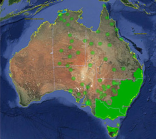
Trimble VRS Now coverage in Australia. Photo: Trimble
Trimble, together with its distribution partner Ultimate Positioning Group, announced the availability of Trimble VRS Now correction service in Queensland, New South Wales, South Australia, Tasmania and Victoria.
Trimble is also now offering the Trimble VRS Now correction service in Oregon’s Willamette Valley.
The commercial subscription service provides surveyors, civil engineers, geospatial professionals and other industry specialists in these areas with instant access to real-time kinematic (RTK) GNSS corrections without the need for a base station.
Using both GPS and GLONASS constellations, the Trimble service delivers centimeter-level RTK corrections customized for each GNSS receiver’s location anywhere in the network via cellular communications. The Trimble VRS Now service supplies accurate, reliable and easy-to-use GNSS positioning for a variety of applications including surveying, urban planning, urban and rural construction, environmental monitoring, resource and territory management, disaster prevention and relief and scientific research, Trimble said.
“The addition of VRS Now to Trimble’s current portfolio of corrections technologies and services in Australia highlights our ability to meet any accuracy, delivery, availability and financial consideration across a variety of applications and markets,” said John Sprivulis, business area director of Trimble’s Positioning Services Division in the Asia Pacific. “Trimble is effectively creating a national positioning infrastructure to meet Australia’s future needs.”
Trimble VRS Now in Australia is a continuation of Trimble’s focus on providing solutions that enable customers to increase productivity by simplifying access to high-precision accuracy around the world. Similar VRS Now services are operating in parts of the U.S. and Europe.
In addition, the Australian VRS Now service supports the Trimble Pivot Field Mobile App, which provides up-to-the-minute information on the VRS Now system status for users in the region.
Because OmniSTAR CORS service in the area is being phased out, existing Australian users will be automatically transitioned to the Trimble VRS Now service, which provides easy access to high accuracy and reliable positioning within the network coverage area.
Service in Australia and Oregon is a continuation of Trimble’s focus on providing solutions that enable customers to increase productivity by simplifying access to high-precision positioning around the world. Similar VRS Now services are operating in Illinois, Indiana, Iowa, Nebraska, Colorado, Florida, Alabama, Mississippi, Texas, and parts of Europe.
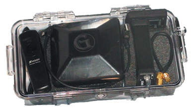
Components easily pack into a baseball-style case. Photo: Nicholas DiGruttolo
By Nicholas DiGruttolo
When asked to do a small survey job overseas, we were concerned about shipping bulky and expensive survey equipment. Shipping costs are not trivial. Add to that the real possibility that your survey equipment may be confiscated by the local authorities, as ours was in Djibouti, and the cost of shipping equipment becomes a substantial part of the overall job. There should be alternatives, especially if accuracy requirements are not stringent.
Faced with this problem for a second time, we considered a new receiver system that has many advantages over conventional survey-grade GNSS receivers: It is small, lightweight and low-cost without sacrificing performance, making it ideal for precision surveying in remote areas of the world and for traveling to the job site by commercial airline. All the components, including the tripods, rods and batteries, are constructed from commercial off-the-shelf (COTS) components. A complete base and rover kit fits in a baseball bag and weighs less than 10 kilograms. The kit is sized and approved as carry-on luggage.
The system is scalable from a simple single-frequency semi-mobile receiver for control networks and some semi-kinematic mapping applications, to a dual-frequency network RTK solution.
The system comes with free processing software that supports carrier-phase relative positioning in real time and post mission, as well as precise-point positioning (PPP) and CA-code differential correction. The software is designed with a simple user interface for easy selection of base and rover data or automatic data download of the closest Continuously Operating Reference Station (CORS) from the U.S. National Geodetic Survey database.
Complete survey set including GNSS receiver, antenna, battery and cables, fits in a small handheld plastic case. Photo: Nicholas DiGruttolo
The system fills a gap between survey applications, where centimeter-level precision is an absolute necessity, and mapping applications, where meter-level is tolerable. The product offers sub-foot precision in most cases and centimeter precision in ideal situations.
Our team recently performed topographic mapping of an oil refinery site in Saudi Arabia and surveyed a precise-elevation network in Sarasota, Fla., to research the effects of sea-level rise. The small size of the COTS components simplified transport to Saudi Arabia, eliminating additional airline baggage fees and easing import through customs. Researchers performing the sea-level study reduced field time by increasing the number of receivers needed to observe a robust vertical control network.
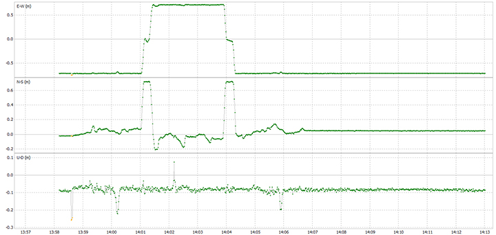
Oil Refinery. The oil refinery project entailed mounting a GNSS antenna on the roof of an off-road vehicle and driving multiple transects around the 18-kilometer perimeter of the site to record the elevation of the terrain. Kinematic data was recorded at 1 Hz using a GPS-only version of the single-frequency receiver. Baseline length to the local reference station varied from less than 1 kilometer to about 10 kilometers. The site was open desert with no overhead obstructions or sources of multipath other than the roof of the vehicle on which the antenna was mounted. Post-processing and comparison to simultaneously collected data from a high-precision survey-grade receiver revealed positional accuracy of about 5 centimeters horizontal and 10 centimeters vertical, when the system’s trajectory was compared to the truth trajectory provided by the survey-grade receiver. Figure 1 shows the difference between the two trajectories. The system’s antenna was 2 feet away from the survey-grade antenna along the driving direction of the vehicle; the trajectory was mostly in the north-south direction and hence the 0.6-m offset in the plot!
Figure 1. Antenna location difference in the sub-decimeter range between the survey-grade system and the compact low-cost system. Note: A 0.6-m offset is to be removed from the difference, as the two antennas were mounted 0.6 m apart in the vehicle driving direction.
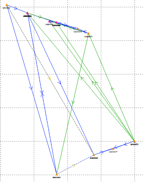
Sea Level. The sea-level-rise study required a high-accuracy vertical control network to cover a 2,500 hectare area. The purpose of the network is to determine the shortest term effects of sea-level rise with a rate of 1.8 millimeter/year in the affected area. Ten benchmarks were established throughout the area of interest, and a robust network of static observations was performed with a combination of two dual-frequency and two single-frequency receivers. The single-frequency receivers were GPS-only units where two standard 4-inch patch antennas were mounted on rods adjusted to a 0.9-meter height. The addition of two receivers provided greater redundancy and a stronger network solution in much less time than would have been possible with only one pair of survey-grade receivers. Figure 2 shows the addition of several loop ties to the network as a result of adding the two roving, lightweight receivers.
Figure 2. Sea-level rise monitoring network showing increased tie points and redundancy as a result of adding the extra lightweight precision receivers to the survey-grade receivers.
Nicholas DiGruttolo works as a field surveying manager for JBrown Professional Group Inc., Northrop Grumman Corporation, and has recently become vice president of surveying.
DigPilot, a Norwegian supplier of surveying equipment and instruments for building and construction, has developed a flexible 3D machine guidance system based on Septentrio’sAsteRx2eH OEM GNSS receivers.
AsteRx2eH is a single-board dual-frequency dual-antenna 272-channel GPS/GLONASS OEM heading receiver, which provides 20-Hz data output of position, heading and pitch/roll data to the machine guidance system. As a member of Septentrio’s AsteRx family of compact OEM boards, the AsteRx2eH receiver is built around the same advanced GNSS chipset and shares the family’s all-in-view GPS and GLONASS tracking and advanced signal processing algorithms for robust tracking and high-precision positioning, even in challenging environments.
The DigPilot machine guidance system uses wireless technology for all of the installed sensors, instead of being hard-wired into the machine. All the components come packed in a hardened plastic case for transportation from one machine to another. The sensors can be clipped into brackets on the excavator arm and cab and calibrated to the machine and bucket in a matter of minutes, Septentrio said. The operator uses an intuitive graphics display on a rugged touchscreen console to control the arm and shovel following a preloaded grade plan.
The DigPilot machine guidance systems have been documented to improve on-the-job safety, productivity and quality of work while reducing costs dramatically. With the DigPilot system, companies can move the 3D guidance system around the fleet of construction equipment as needed, at a fraction of the cost of installing hard-wired systems on multiple machines, Septentrio said.
DigPilot customers are also using APS-3 GNSS RTK receivers from Altus Positioning Systems, a Septentrio company, in conjunction with the on-board machine guidance system for high-precision site surveys and as-builts.
“With the Septentrio OEM receivers we know we can count on the highest levels of accuracy, reliability, ruggedness and performance,” said Jan Floberg, CEO and founder of DigPilot. “We tested all other available GNSS products on the market before deciding on Septentrio. The AsteRx2eH outperforms the other brands in its ability to obtain and hold fix and heading in the rugged terrain of western Norway. We have deployed over 1,000 systems to date.”
Altus and Septentrio products will be on display at World of Concrete in Outdoor Booth 032025 at the Las Vegas Convention Center, Feb. 3-6.
Eos Positioning Systems has introduced a new line of high-accuracy GNSS receivers for smartphones and tablet computers, including both sub-meter and RTK performance for all mobile platforms: iOS, Android, and Windows.
Eos’s entry-level product, the Arrow Lite, is Bluetooth compatible with all mobile devices.
The Arrow 100 is Eos’s advanced real-time, sub-meter GNSS receiver that utilizes both GPS and GLONASS, and is expandable to Galileo, Beidou and QZSS. It offers superior tracking under tree canopy, around buildings and in rugged terrain, the company said. In addition to supporting SBAS in North/Central America, Europe, Northern Africa, Japan, India and Russia, the Arrow 100 also supports OmniSTAR’s worldwide, real-time sub-meter service.
The most advanced Arrow receiver is the Arrow 200, a dual-frequency, multi-constellation RTK GNSS receiver capable of 1-cm accuracy in real time. The Arrow 200 is an iOS-compatible RTK and OmniSTAR receiver that works with all models of iPads and iPhones via wireless Bluetooth connection. An iOS NTRIP app that allows the user to log into any available RTK network. The Arrow 200 will provide quality RTK performance for years to come because it supports current and future satellite constellations: GPS, GLONASS, Galileo, BeiDou and QZSS, the company said. It also supports OmniSTAR’s G2, XP and HP real-time worldwide decimeter services.
“After spending more than 12 years designing high-accuracy Bluetooth GNSS receivers, I believe Eos has set the new standard for high- accuracy GNSS receivers that work across all mobile platforms, no matter if it’s iOS, Android or Windows,” said Chief Technology Officer Jean-Yves Lauture.
All Arrow receivers employ long-range (1-km) universal Bluetooth connectivity so the user can interface to any brand of smartphone or tablet, whether it’s iOS, Android, or Windows-based. A variable-power Bluetooth implementation allows the Arrow receivers to communicate up to one kilometer from the mobile device.
Arrow receivers have been optimized to run all day on battery power. The battery pack is field-replaceable and rechargeable separately. It contains smart charging logic so expensive battery chargers are not needed.
All Arrow receivers have been designed to meet IP-67 specifications for immersion in water and are completely dust-proof so they will survive in the harshest environments.
The Arrow receiver product line is targeted at high-accuracy applications like GIS, environmental, agriculture, electric/gas/water utilities, surveying, machine control, and federal/state/local government.
GeoLearn is offering seven new GNSS courses taught by Bill Henning, a professional land surveyor who was instrumental in developing RTK guidelines for surveyors at the National Geodetic Survey (NGS). With GeoLearn, he expands on the basics of positioning with RTK and adds a special three-course series on heighting with GNSS.
Henning’s four courses on RTK dissect how GNSS works, covering the physics and surveying implications of what affects the signals from space, benefits and costs of single base versus real-time networks, and best field methods to maximize a surveyor’s effectiveness with RTK. His heighting series (three courses) covers the interrelationships between gravity and heights, use of the NGS hybrid geoid model and height modernization procedures, and use of the NGS 58 and 59 guidelines and real-time precision.
Instructor Bill Henning
“I’ve tried to incorporate the very latest in the science and practical knowledge that many have developed at NGS in collaboration with public and private partners on the subject of effective RTK use and heighting with GNSS,” Henning said.
“We were so pleased when Bill agreed to teach this series of courses,” said Joe Paiva, CEO of GeoLearn. “Bill is a national treasure to surveyors and we are pleased to be able to extend his legacy to the public beyond his tenure with NGS.”
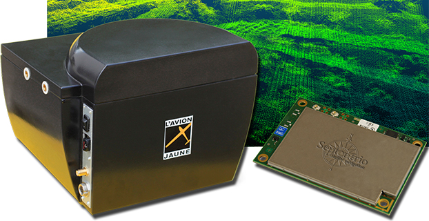
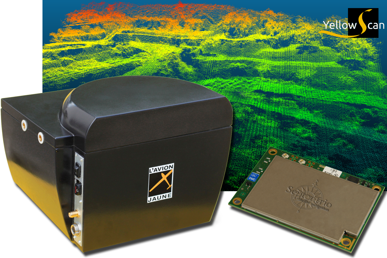
L’Avion Jaune, a service provider and airborne sensors integrator in the field of aerial surveys, has selected the Septentrio AsteRx-m to equip its YellowScan unmanned aerial system. L’Avion Jaune chose the AsteRx-m for its robustness and low-power consumption, Septentrio said.
YellowScan is the a lightweight all-in-one solution designed to deliver quality aerial surveys carried out using a LiDAR sensor aboard UAVs. The self-contained system integrates into a small package all the necessary equipment for conducting airborne surveys: a 3D laser scanner, an AHRS, a controller, an autonomous power supply module and the AsteRx-m, a high-performance precision GNSS receiver.
The AsteRx-m provides a compact and low-power solution for precise positioning in difficult environments where the tracking of both GLONASS and GPS satellites allows the receiver to improve the availability and robustness of a positioning solution. Septentrio’s newest RTK models optimally adapt to situations where GNSS signals can be distorted by reflective surfaces and feature unique countermeasures to disturbances, maintaining accurate and stable measurements wherever and whenever centimeter-level accuracy is needed, the company said.
“The easy-to-integrate AsteRx-m has proven to deliver the most reliable and stable RTK performance of all, in a compact and exceptionally low-power consumption module,” said Michel Assenbaum, CEO of L’Avion Jaune. “The AsteRx-m allows us to extend the operational range and capabilities of the YellowScan, a fully autonomous surveying solution dedicated to UAVs. We have tested the solution in various environments across the world and have never seen it falter.”
“We are delighted that L’Avion Jaune, a respected expert in designing unmanned-aerial remote sensing solutions, has validated the excellent performance of our ultra-compact GNSS receiver,” said Jan Van Hees, head of business development at Septentrio. “We are impressed to see how much interest YellowScan has drawn since its introduction and we are very proud to be contributing to the success of a best of breed solution in this highly competitive market.”
Altus Positioning Systems, a Septentrio company, has integrated its APS-GeoPod product with Entegra Technologies’ Crossfire Pro Tablet. This collaboration, targeting the oil and gas, survey, GIS and transportation industries, provides a high-performance tablet-based solution for enabling ultra-precision RTK of sub-meter or centimeter accuracy.
Altus is showcasing the APS-GeoPod and Crossfire Pro tablet, along with the full range of Altus products, at booth A1.060 and outside Booth FG.006 at InterGeo 2014 being held this week in Berlin, Germany.
According to Altus CEO Neil Vancans, the Altus APS-GeoPod and the Entegra Crossfire Pro Tablet provide a combination of precision, performance and features that make it ideal for energy services, land surveys and other GIS-related applications.
APS-GeoPod is a compact GPS/GLONASS RTK and DGNSS receiver that adds high-precision RTK positioning to USB-compatible tablet PCs. “This unique product gives users the convenience of adding RTK precision to any on-board application on mobile devices geared to the field service professional,” Vancans said.
The Entegra Crossfire Pro tablet. Photo: Altus Positioning Systems
APS-GeoPod features include:
Compact dual-frequency GNSS module
Low power consumption (<1 Watt)
USB 2.0 interface
Internal L1 GPS/GLONASS antenna
NMEA integration with GIS software
The Crossfire Pro tablet features the multi-touch interface and communication capabilities of smartphones, the large display and ergonomics of consumer tablets, and the daylight-readable screen and durability of rugged tablets. Safety features include UL 1604 Class I/Division II certification for operation in hazardous locations. To users, Crossfire Prodelivers a customizable tablet for exacting daily activities, resulting in greater efficiencies, response times, productivity and customer service levels, the companies said.
Hemisphere GNSS has announced two low profile, multipurpose antennas that it says will exceed expectations in all GNSS applications. With unique filtering patterns and precise attention paid to mitigation of multipath and interference, the A25 and A45 antennas complement all GNSS products, from L1 GPS to multi-frequency, multi-constellation.
The A25 and A45 have been designed to support millimeter accuracy for land and marine applications. Both antennas support present and future GNSS signals, including GPS, GLONASS, BeiDou, QZSS, and Galileo. The A25 supports the previously mentioned signals at a single-frequency level, while the A45 supports these signals at a multi-frequency level.
“We’ve designed these antennas to excel in challenging environments such as near buildings or under foliage,” said Lyle Geck, senior manager of product marketing at Hemisphere GNSS. “They have superior multipath mitigation, stable phase centers and strong SNR’s, even at low elevations.”
The ruggedized housing used by both antennas is made of an aluminum base that has been pretreated for the marine environment and will withstand salt, fog, and spray. The antennas pass the two-meter pole drop test.
The A25 is a multi-GNSS precision antenna, designed for a variety of applications including GIS, single-frequency RTK positioning and navigation, and precision guidance. The A45 is a survey-grade, multi-GNSS precision antenna for a variety of applications including surveying, RTK positioning and navigation, precision guidance, and machine control.
Topcon Positioning Group and MAVinci GmbH have released the latest version of the Sirius Pro surveying UAS (Unmanned Aerial System) program, designed to be compatible with existing RTK (real-time kinematic) base stations or NTRIP (network transport of RTCM data over IP).
“By connecting an external base station, Sirius Pro will receive the RTCM correction signals and deliver 2-5 centimeter accuracy without using ground control points,” said Eduardo Falcon, executive vice president and general manager for the Topcon GeoPositioning Solutions Group. “When you have mobile Internet on your site, you can achieve the same accuracy even without a local base station using NTRIP.”
Sirius Pro is designed to deliver orthofotos and three-dimensional elevation models with a high absolute accuracy of 2-5 centimeters without using ground control points. “Combining MAVinci‘s precision timing technology with Topcon sub-centimeter grade L1/L2 GPS/GLONASS RTK receivers, this robust system stands up with a clever solution that helps in the realizing of projects in a better and faster way,” said Johanna Claussen, CEO at MAVinci.
For users who do not have an RTK base station, an internal base station add-on for the Sirius Pro is available. “It upgrades the Sirius Pro to its full functionality: Use of an internal or external base station depending on your needs,” Claussen said. “This add-on is available anytime via Internet without changing your hardware.”
Sirius Basic is an entry-level solution for UAS surveying, and delivers orthofotos and 3-D elevation models. The system is designed to offer high-accuracy when using ground control points. “Sirius Basic offers you full flexibility,” said Falcon. “It can be upgraded to Sirius Pro via an Internet update later on — no hardware change is necessary.”
The system will be available at the Intergeo trade show for geodesy in October and thereon. The Topcon and MAVinci UAS was first introduced at Intergeo 2013 for the European market and was recently made available in the North American market.
 World Congress 2015, sponsored by the