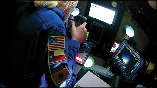
New solution eliminates positioning errors in logistics, rail, and public safety by providing lane-level accuracy natively on rugged mobile devices.
Swift Navigation, a global leader in precise positioning technology, and RugGear, a manufacturer of rugged mobile devices for professional use, have joined to embed high-accuracy positioning capabilities into RugGear’s enterprise and mission-critical mobile devices.
The partnership integrates Swift Navigation’s Skylark Precise Positioning Service directly into RugGear devices built on the Qualcomm Snapdragon 6 Gen Platform. This native integration delivers reliable lane-level accuracy — an order of magnitude improvement over standard GPS — without requiring any external receiver or configuration. Precise positioning is available out of the box, ensuring seamless performance across rugged mobile form factors.
This integration is a major step in bringing high-accuracy positioning to industrial mobility. All location-based applications benefit automatically, meaning developers do not need to modify their existing apps.
Enhanced Capabilities with the RG940
The first device to integrate Skylark will be the RG940, a high-performance, rugged 10.1-inch tablet designed for demanding industrial uses. The high accuracy improves operational efficiency and accountability across enterprise segments, including:
Logistics and Waste Management. Optimizes routes, reduces fuel costs, and provides indisputable proof of service records for liability claims.
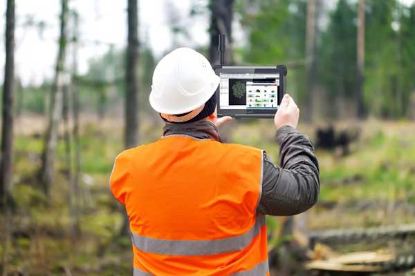
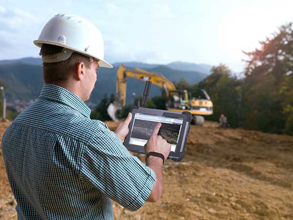
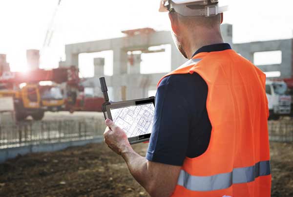
Construction. Provides a value-engineered approach for GIS mapping assets and enhances worker safety through geofenced “no-go” zones.
Rail. Enhances safety and efficiency for trains and prevents freight car loading errors.
Interested customers and partners are invited to contact RugGear directly for availability and technical specifications.
The Algiz 10XR’s screen features a glove/rain mode. (Photo: Handheld)
Handheld Group, a manufacturer of rugged mobile computers, has released the Algiz 10XR, a rugged 10-inch Windows tablet that combines durability with a GNSS receiver, 5G and future-proof features.
The Algiz 10XR was developed for field work or other challenging environments in markets such as logistics, mining, public transport, public safety, waste management or geographic information systems (GIS). It also has also been designed with customization in mind.
The tablet has a dedicated multiband GNSS u-blox NEO-M8U receiver for accurate positioning. The NEO-M8U module offers u-blox’s untethered dead-reckoning technology, which provides continuous navigation even under weak GNSS conditions.
Other key features
future-proof 5G communication for live video streams and bandwidth-heavy tasks such as mapping
Intel Elkhart Lake x6000 platform for reliable performance
Windows 10 Enterprise LTSC (64 bit)
high-resolution, sunlight-readable 10-inch touchscreen with super-hardened glass and rain-and-glove mode
future-proof 5G capabilities, 4G/LTE high-speed data, Wi-Fi, Bluetooth
IP65 and MIL-STD ruggedness
full-day, hot-swappable battery
optional, integrated barcode scanner and near-field communications.
The tablet is supported by a broad set of accessories for field professionals: carry cases, vehicle cradles, pole mounts, extended batteries, and a vehicle dock with antenna pass-through for both GPS and Wi-Fi.
“The Algiz 10XR will bring some great performance gains for our partners and customers who rely on Windows tablets in the field,” says Johan Hed, Handheld chief product officer. “We’ve worked with this segment for decades now and are confident that we’ve developed a device with not only great specs, but a complete accessory package to help our customers with their fieldwork.”
The new device will ship in the fourth quarter of this year and is available for pre-order
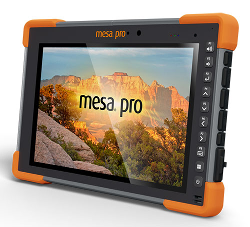
Juniper Systems is entering the 10-inch rugged tablet market with the launch of its Mesa Pro rugged tablet. The Mesa Pro features 11th Generation Intel Core processors, a Windows 11 operating system, device customization options, a large sunlight-readable display and “Juniper Rugged” company design.
“We are excited to be entering the 10-inch rugged tablet segment for the first time,” said Darren Hellstern, the Mesa Pro product manager at Juniper Systems. “Mesa Pro offers powerful processing, a rugged design meant for any environment, and is a versatile workstation that can be used in the office or the field.”
Standard Mesa Pro units come equipped with an 11th Gen Intel Core i5 processor and 16 GB of LPDDR4x RAM. Core i7 and Celeron versions of the device are also available.
Each Mesa Pro configuration offers powerful performance and allows users to select a level of computing performance that best fits their needs while having options that meet their budgets.
“It was important for us to offer performance tiers,” said Hellstern. “This is the first time we have offered various performance levels in one of our devices. The needs that our customers and users have varies greatly. From running CAD programs, viewing construction plans, mapping and mounted-vehicle solutions, we feel that we have an offering with Mesa Pro that fits the processing need of the user. We are also available to help users determine what level of performance they need.”
Mesa Pro joins the current Mesa family of 7-inch devices and helps Juniper Systems achieve its mission of providing powerful rugged computing and data-collection devices to mobile field workers everywhere. The Mesa 3 runs on either Windows or Android operating systems. The Mesa family started in 2010 with the launch of the Mesa Rugged Notepad.
“Mesa devices have served our customers for over a decade,” said Hellstern. “We are proud to add Mesa Pro to that list of incredible devices and offer more options to our customers and users around the world.”
Juniper Systems is now accepting pre-orders for the Mesa Pro.
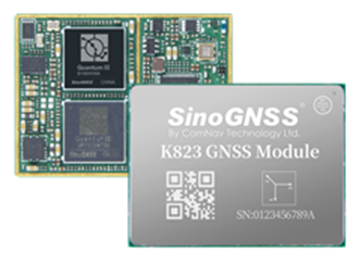
ComNav Technology has released the P300 Series GNSS tablet to the global market. Based on the company’s K8 GNSS OEM platform, the high-precision in-cab Android rugged tablet brings innovative performance and ease of use to various operations in precision agriculture, autonomous driving, machine control and other industries, the company said.
Embedded with the new-generation K8 OEM module, the P300 series GNSS tablet can track all current and planned constellations (including GPS, BeiDou, BeiDou-3, GLONASS, Galileo, QZSS) and reach centimeter-level accuracy. Using the advanced Quantum III technology in combination with upgraded SinoGNSS ASIC chip and advanced microprocessor unit, the P300 series is capable of providing enhanced heading and positioning performance for everyday field use.
Photo: ComNav
Features of the P300 include dual-card, dual-standby, various interfaces, multiple wireless connections and data transmission modules for CAN, PPS and Event. The P300 can adapt to a variety of application scenarios to meet different needs of users. The aluminum-magnesium alloy body makes the P300 robust, able to cope with the rigors and demands of tough construction jobs and strenuous vibrations.
The P300 series runs the Android operating system and is compatible with most Android apps. Compared to traditional GNSS receivers the high-definition color touchscreen and intuitive interface make it easy for both beginner and advanced users to operate.
The P300 series tablet includes P300 Plus (10.1-inch) and P300 Mini (8-inch). Both deliver the same high performance, user-friendly design, powerful connectivity and rugged construction to users. Both sizes are available now.
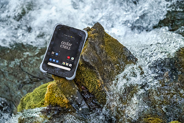
Juniper Systems is has launched its latest rugged tablet, the Cedar CT8X2. The new tablet offers increased processing power, RAM and storage, running on the Android 10 operating system. Despite these features, the CT8X2 retains the same powerful GNSS functionality of the previous Cedar generation for the same price.
“The CT8X2 is our best Cedar tablet to date,” said Cody Draper, Cedar product manager. “It exceeds expectations in terms of price, performance and versatility. It is a perfect device for those looking for a mobile data-collection device that offers a much greater degree of ruggedness than a consumer product.”
Powered by an octa-core Snapdragon CPU from Qualcomm, the CT8X2 allows for larger files compared to the previous Cedar. Greater onboard storage prevents users from needing to offload data frequently and provides sufficient space for applications. With GNSS accuracy of about one meter in open skies and five meters under tree canopy, the CT8X2 offers capable GNSS positioning that far exceeds the accuracy of typical consumer devices. The CT8X2 also has a high-resolution screen.
“The performance increase of the CT8X2 gives users a very capable device in the field,” Draper said. “We were able to provide these advancements in performance and GNSS accuracy while maintaining our affordable price point.”
The T100 tablet is designed for use in the field. (Photo: Trimble)
Rugged tablet operates seamlessly with Trimble Site Positioning Systems and Trimble Siteworks Software
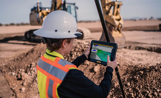
Trimble has announced the Trimble T100 Tablet, a high-performance tablet providing fast data processing for construction surveying applications. The rugged tablet brings fast computing and a large screen to the field, incorporating:
Directional keypad with programmable function keys
Large internal battery (92Wh)
Powerful Intel i5 processor for fast data collection, processing and quality assurance
USB-C fast-charging capabilities
Expandable dual EMPOWER module system, engineered to exceed the expectations of the outdoor field worker
User-configurable performance settings
IP-65 environmental specifications
Two bracket options for different display angles on the pole, enabling users to measure different locations more easily, with maximum flexibility for hard-to-measure locations
Optimized for Trimble Siteworks Software and supporting office applications such as Trimble Business Center, the T100 is suitable for both experienced and novice users. With accessories designed to specifically complement user workflows, the T100 avoids the burden of carrying multiple computing devices, while enabling users to complete quality assurance and quality control before leaving the field.
“The T100 tablet features the quality you expect from Trimble, with the flexibility to adapt to a variety of configurations and job site conditions,” said Scott Crozier, vice president of Trimble Civil Construction. “It is engineered to be ergonomic and portable on and off the pole, enabling users to stay mobile while they work, with features that increase productivity and reduce downtime.”
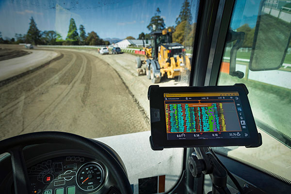
Earthworks Upgraded for Soil Compactors
Wider Range of Machine Types Now Available on the Trimble Earthworks Platform
Trimble Earthworks for soil compactors is a GNSS-based, 3D compaction control solution designed to make soil compaction more accurate, faster and easier. Operators will experience the same intuitive, easy-to-use Trimble Earthworks software interface currently available for excavators, dozers and motor graders for improved productivity.
Trimble Earthworks now includes soil compactors. (Photo: Trimble)
Compaction Control. Trimble Earthworks for soil compactors enables contractors to accurately control the compaction process, while reducing unnecessary passes that can result in over compaction. The platform makes the overall compaction process more efficient, with a higher level of accuracy and less rework. With soil compaction part of the extensible Trimble Earthworks platform, contractors can take advantage of shorter training times, less downtime and increased remote operator support in the field as well as benefiting from ongoing platform developments.
“Trimble Earthworks for soil compactors is easy to learn and more accessible for many different types of users because it leverages the intuitive Trimble machine-control interface and applies it to soil compactors,” said Scott Crozier, vice president of Trimble Civil Construction. “Adding this new machine type to the Trimble Earthworks platform gives contractors the ability to more easily manage their mixed fleets, train operators and manage jobsite data.”
Improvements in material/surface lifts and layer management allow for more accurate data and easier data management. Office-to-field connectivity enables efficient communication and data transferring across the project. In the field and office, contractors can easily interpret the valuable productivity data collected from the machine, such as work previously completed versus work completed that day.
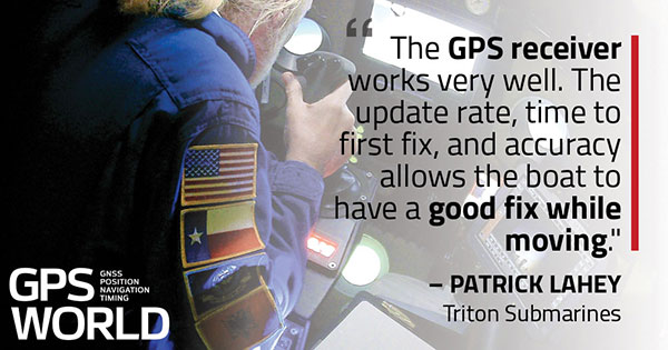
Triton Submarines — famous for underwater explorations including that of the Titanic — has replaced large, outdated computers onboard with rugged tablets. Each sub is equipped with two Panasonic Toughpad FZ-G1 tablets to monitor depth, light, voltage, gases and alarms, as well as input data and run analytic software. On the surface, a Toughbook 54 is used for tracking and communication.
Photo: Caladan Oceanic
Integrated GPS receivers simplify mapping, allowing teams to plot the location of a vessel in real time. “We use the GPS receiver inside the Toughbook 54 for positioning of the surface boat to aid in tracking of the sub,” said Patrick Lahey, president of Triton Submarines. “The GPS receiver works very well. The update rate, time to first fix, and accuracy allows the boat to have a good fix while moving, and for a quick restart during operations at sea.”
Photo: Caladan Oceanic
Once the sub is submerged, it loses all radio communications including GPS. An underwater positioning system based on acoustics is used instead, Lahey explained. The USBL system uses a surface base station mounted on a boat and GPS to determine its location. Then, using an array of acoustic transducers, it sends a ping to the sub and the sub pings back. The surface unit then measures the travel time to each transducer to find the sub’s position.
Technology continues to develop and put more capability, data storage and ease of use into many professional’s hands, and surveyors are no different in their needs.
Spatial data collection has become an important task in the diverse service world of today’s surveyor with a variety of platforms, sensors and techniques being used to provide this operation.
The movement toward completing a “digital twin” of existing improvements and facilities worldwide has opened the door for new means and methods for data collection. Surveyors are taking a front-line role in producing the spatial data necessary for much of the internal and external infrastructure being used in today’s cutting-edge digital modeling.
Necessary accuracy and precision
However, not all data-collection systems offer the accuracy and precision deemed necessary by today’s surveying profession. These systems also need to be tough enough to handle the environmental conditions surveyors face in their everyday work, yet be user-friendly enough to make the data-collection process efficient.
Surveyors require a system designed for rugged use, yet built with a high-visibility screen, easy-to-use interface and reasonable battery life to allow effective and confident data collection. Many data collectors tout these features, but many of them fail when subjected to the harsh conditions of surveying and construction sites.
Times, however, are a changing and a new tablet is raising eyebrows.
DT Research Inc., a Silicon Valley electronics provider, has provided mobile and medical computing devices to many professions for more than 20 years. They have taken one of their most popular models, the DT301, and added integrated significant upgrades that brings it squarely into the surveying and geospatial world.
This rugged tablet can now include a multi-frequency GNSS module and a second, 3D-capable, stereo-imaging camera for capturing photometric information.
High-capacity, hot-swappable battery pack with power-saving modes
IP65-rated for water and dust resistance
MIL-STD-810G for shock and vibration protection
MIL-STD-461F for EMI and EMC tolerance
Multi-frequency GNSS (including GPS, GLONASS, Galileo and BeiDou)
External GNSS antenna capable
Intel RealSense Depth camera, 2D barcode scanner
Long-range Bluetooth, 4G LTE, digital pen support
Sturdy external keyboard with various mounts for static installation
Rugged yet reasonable weight of 3.1 pounds
Multiple mounting options for precise measurement
Rugged, but not too heavy
The first impression a new user of the DT301X-TR will notice is that while it is heavier than the normal personal tablet, it is very rugged yet not noticeably heavy. The additional weight it does carry, however, gives the user a sense of durability and confidence to take it into fouler environments without fear of infiltration or hazardous climate concerns.
The external bumpers can take significant abuse, and the rubber rear guard is used for gripping the tablet effectively during data collection tasks. Several mounts are available for this unit, including a pole mount in conjunction with the external GNSS antenna for higher accuracy location determination.
This unit runs the Microsoft Windows 10 IoT (internet of things) Enterprise operating system, so most users will already have a general feel for the overall interface. All the normal Windows tools are there (email, browser, etc.), so little training is needed for beginners.
Connectivity is available through dual-band Wi-Fi and/or 4G LTE communications as well as long-range Bluetooth connections where needed. The unit runs on an Intel 8th-generation core processor and SSD storage for fast computing and data access needs.
In addition to computing performance, this model also exceeds expectations with its robust screen. Where most high-def screens on phones and tablets suffer in daylight conditions, the DT301X-TR allows the user to maintain great visibility and keep working with visual confidence.
GNSS module and antenna
The DT301X-TR can be loaded with several data-collection software packages, depending on your application. For traditional surveying, Microsurvey’s Field Genius is used for locating survey points with the GNSS module. Several programs for data collection are available, depending on the accuracy required by the user.
Photo: DT Research
A helical mobile dual-frequency GNSS antenna is mounted directly on the tablet for receiving survey-grade positions with an RTK correction service. The tablet can also be used with an external GNSS antenna mounted on an extendable pole for a more conventional surveyor-style method of data collection while providing stability for the user.
The data-collection process for mapping is intuitive and allows for uploading existing shapefiles for reference to existing conditions. Exporting information after the data-collection task can be completed in two different formats: shapefiles and KML files.
Photo: DT Research
For the higher accuracies typically required for surveyors, the unit utilizes the pole mount to ensure the accuracy level is not compromised by human interaction, and it connects to an external GNSS antenna. The software allows the user to collect more precise locations through several means: static, real-time kinematic from the user’s base station, or through a real-time network solution from an external source.
The data collection process in Field Genius is very user friendly and allows for customized point naming and automatic linework between points. Field Genius also contains standard COGO tools and routines that allow the user to perform field calculations right on the job, saving valuable time and money for the practitioner and the client.
Exporting of field data is robust and allows for creation of DXF/DWG files of linework and LandXML files for surface and point downloads. The user can also export raw data in a GNSS Survey format or the industry standard “field book” format as well. Importing background files is just as simple, so the user can have additional information at their fingertips for reference during their data collection process.
Also, the DT301X-TR can be utilized for construction staking with an extensive array of staking reports available for user verification. Proposed TIN surface models can be imported for site and roadway staking for placing cut/fill points on the fly.
Cameras make it shine
The DT301X-TR, however, is not just a fancy conventional surveying data collector; the Intel RealSense Depth camera and DOT3D Pro software from DOT Product is the latest development to be added to the rugged tablet that makes this platform shine. This latest technology from Intel allows the user to photograph and video spaces that even the newest laser and lidar scanning equipment can’t access.
Stereo depth modeling is enhancing the data-collection process for surveyors as a new tool to collect important information for engineers, architects and contractors. By collecting close quarters information in real time, a more complete BIM and/or “digital twin” data set can be accomplished faster and more cost efficiently than ever.
This version of remote sensing is becoming very popular with other vehicles and platforms (such as UAVs), yet being integrated into a single unit with GNSS capability is key to making the DT301X-TR a game changer.
The divide between the macro (GIS mapping) and micro (traditional surveying) of spatial data collection is closing, but it will take some time before satisfying the surveying community. The DT301X-TR is closing that gap by marrying the accuracy of GNSS measurement with the precision of 3D analyzation technology.
DT Research began by creating a bulletproof tablet made for durability and dependability, but has raised the bar with a state-of-the-art satellite measurement module and remote-sensing capability through the RealSense camera system.
Wrapping all this technology into a rugged unit running on an industry-standard software platform, DT Research has provided an insight to what the future of data collection looks like, no matter what profession one is in.
DT Research has designed a new rugged tablet with 3D imaging that is purpose-built for 3D mapping with a built-in GNSS module.
The DT301X has an Intel RealSense Depth camera that provides real-time 3D imaging combined with dual-frequency GNSS module for real-time mapping and positioning. The digital images are better than high-definition standard, and are suitable for construction building information management (BIM) graphics.
The DT301X rugged tablet is compatible with existing applications with Microsoft Windows 10 IoT Enterprise operating systems for flexible integration, and it brings together the advanced workflow for data capture, accurate positioning and data transmitting.
Key features of the DT301X
Highly durable. IP65 and MIL-STD-810G rated tablet in a slim case offers the versatility to be used in the field, office and vehicles.
Indoor/outdoor display. A high brightness 10.1-inch touchscreen offers flexible viewing in a wide range of lighting.
Wi-Fi and Bluetooth. Long-range Bluetooth for 1000-foot range and 4G LTE mobile broadband for the latest in high-speed communications.
High performance. Intel 8th-generation Core i5 or i7 processor offers high-performance while still being energy efficient.
Hot-swappable batteries. With high-capacity 60- or 90-watt hot-swappable batteries, the DT301X keeps working continuously.
CHC Navigation has launched its LT700 rugged Android tablet. The LT700 is designed to increase the efficiency and productivity of the mobile workforce in different industries and applications.
An integrated GNSS module (GPS/GLONASS/BDS/SBAS) provides robust positioning performance. The LT700 dual-SIM 4G modem ensures fast and reliable connection with mobile teams.
The LT700 tablet features an 8-inch sunlight-viewable touchscreen. It displays geospatial information system (GIS) data tables, complex vector and raster maps, or high-resolution pictures in direct sunshine and high-bright areas, CHC Navigation said.
Unlike consumer-grade tablets, the L700 is intended for mobile field workers. Its industrial IP67 design withstands all-day use in harsh environments and conditions, and is protected from dust, rain, extreme temperatures and accidental drops from 1.2 meters. Rugged design, soft corner bumpers and long battery life provide the LT700 with the capability to perform uninterrupted for a complete working day.
The LT700’s octa-core 2.2-GHz CPU supports running large maps and datasets without any lag or slowdown. Driven by Android 8.1 and bearing the GMS (Google Mobile Service) certification, the LT700 runs seamlessly the most common professional data collection applications available from the Google Play store.
RealSense 3D Camera is Fully Integrated to Capture Detailed Images
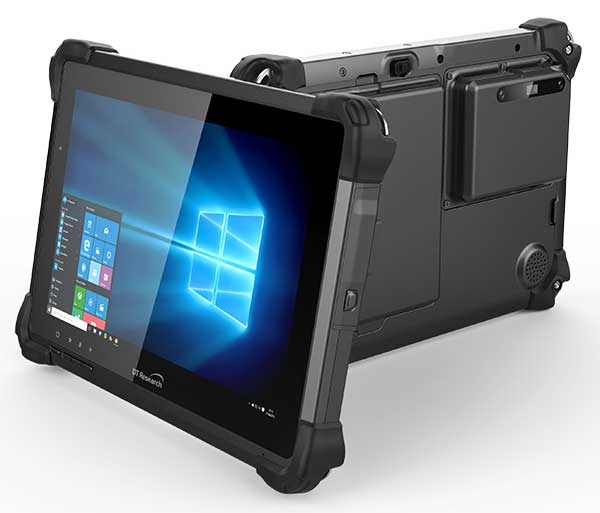
DT301X-TR rugged tablet. (Photo: DT Research)
DT Research is offering the new DT301X-TR rugged tablet, a lightweight military-grade tablet. The tablet is purpose-built to enhance the precision for bridge and construction inspections, 3D surveying and mapping of underground utilities.
The DT301X-TR provides multi-frequency GNSS real-time kinematic (RTK) with carrier phase for mapping and positioning, and supports GPS, GLONASS, BeiDou, Galileo and QZSS.
The optional foldable antenna supports high-accurate measuring field work, which can be measured with RTK GNSS positioning directly, or used to connect to an external antenna for higher precision.
Its 10.1-inch high-brightness capacitive touch screen can be read in a wide range of lighting indoors and outdoors. The tablet comes with a choice of Intel 8th-generation Core i5 or i7 processors. Its MIL spec and IP ratings means it holds up to real-world hazards and performs in many industries and environments.
Integrated 3D camera. The DT301X-TR integrates the optional Intel RealSense Depth camera which provides real-time 3D imaging to quickly and accurately create measurements for CAD, engineering, design, utility and project management, and crime/crash scene forensics. Scientific grade data, which is important for evidence as well as building plans, is now easier to access and use for specialists and non-credentialed workers alike.
With this 3D camera technology, depth perception is integrated to add the most accurate image to make projects stay factual and consistent. The integration of the 3D camera with a rugged handheld tablet improves the mobility and reduces the bulk and limitations of a laser scanner for small, hard-to-reach spaces and brings the measurement, real- time scanning, and positioning together in one device which can also be used to process and transmit the data.
Using rugged tablets with 3D technology allows the as-built status of a project to be tracked and documented in real time, reducing the project cycle time, and also allows data to be shared with the owner, general contractor and subs as it is captured. This boost to efficiency and accuracy validation shortens payment cycles as well as improving the overall BIM (building information modeling), getting infrastructure going quickly and getting payments to contractors faster.
“The combination of the DT Research rugged tablet with the RealSense depth camera and DotProduct’s Dot3D Pro software enables projects to be quickly set up, tracked, and completed for all staff and tasks whether in the office or on the site. The ease of use these tools bring to 3D workflows can benefit a wide range of applications from construction verification to asset management to crime scene mapping.” says Tom Greaves, chief marketing officer at DotProduct.
Data capture options besides the 3D camera are a 2D barcode scanner for equipment/location tags, long-range Bluetooth for 1,000-foot range suitable for connecting to robotic total stations and 4G LTE mobile broadband for the latest in high speed communications.
The flexibility for set up and use is enhanced in the DT301X-TR rugged tablet with Microsoft Windows 10 IoT Enterprise operating systems for convenient integration with existing applications, bringing together the advanced workflow for data capture, accurate positioning and data transmitting.
Another option is a bright LED light that can be attached to the DT301X-TR and stay consistently on for up to two hours, bringing light to underground infrastructure mapping and scanning.
With high capacity 60 or 90 watt hot-swappable batteries, the rugged yet lightweight DT301X-TR keeps working continuously whether in the field, office, or vehicles, complemented with a variety of battery chargers so fully charged batteries are always available.
This rugged tablet gives detailed accuracy combined with the latest 3D camera technology all in one tablet that is rugged and easy to use in the field. Whether at the construction site, mapping underground utilities, or at the freeway crash scene, the cost-effective DT301X-TR is ideal for accurate measurements to enable data-driven decisions, able to travel to wherever the work is.
The DT301X-TR rugged tablet will be available in May 2019 from DT Research’s authorized resellers and partners. DT Research will be at booth 217 at AEC’s BuildTech show.
RealSense 3D camera is fully integrated to capture real-time detailed images
DT301X rugged tablet. (Photo: DT Research)
DT Research has released the DT301X rugged tablet, a lightweight military-grade tablet that is purpose-built to enhance the precision of crime and crash scene reconstruction, bridge and other construction inspections, and 3D surveying.
DT Research made the announcement at Intergeo, being held Oct. 16-18 in Frankfurt, Germany.
The DT301X rugged tablet has MIL spec and IP ratings, yet is lightweight — offering the versatility to be used in the field, office and vehicles, the company said. A high brightness 10.1-inch touchscreen offers flexible viewing in a wide range of lighting, and an Intel eighth-generation Core i5 or i7 processor offers high-performance while still being energy-efficient.
With high-capacity 60- or 90-watt hot-swappable batteries, the DT301X keeps working continuously, complemented with a variety of battery chargers so fully-charged batteries are always available.
The DT301X integrates the Intel RealSense depth camera, which provides real-time 3D imaging to shorten the workflow and create extremely accurate measurements for CAD, engineering, design, utility management and crime-scene forensics.
Scientific grade data, which is important for court evidence as well as building plans, just got easier and is now available to a wider group of workers. With this 3D camera technology, depth perception is integrated to add the most accurate image to make projects stay factual and consistent, DT Research said.
Optional data capture offered on the DT301X besides the 3D camera are a 2D barcode scanner for equipment/location tags, a dual-frequency GNSS module for real-time mapping and positioning, long-range Bluetooth for 1000-foot range, and 4G LTE mobile broadband for the latest in high speed communications.
The rugged tablet gives detailed accuracy combined with the latest 3D camera technology all in one device that is rugged and easy to use in the field.
“DT Research’s high-performance rugged tablet equipped with the RealSense depth camera combined with DotProduct’s Dot3D Scan software allows speedy and efficient field-to-office 3D workflows for a wide range of applications from construction verification to asset management to crime scene mapping,” said Tom Greaves, chief marketing officer at DotProduct.
The DT301X is built to operate in real-world situations, with an IP65 rating for water and dust, MIL-STD-810G for shock and vibration protection, and MIL-STD-461F for EMI and EMC tolerance. The tablet can be paired with a detachable keyboard for ease of use, and Wi-Fi and Bluetooth for smooth networking and constant communications.
The DT301X rugged tablet is compatible with existing applications with Microsoft Windows 10 IoT Enterprise operating systems for flexible integration, and it brings together the advanced workflow for data capture, accurate positioning and data transmitting.
Whether at the electrical substation, at the crash scene, or at the construction site, the DT301X is ideal for accurate measurements as well as other needed tasks, able to travel to wherever the work is.
The DT301X rugged tablet will be available in November 2018 from DT Research’s authorized resellers and partners.