Collins Aerospace has introduced NavHub-200M, a vehicle navigation system for the international market compatible with military code (M-code) receiver technology. The NavHub-200M is not controlled by the International Traffic in Arms Regulations (ITAR).
Collins Aerospace made the announcement at Eursatory 2022, taking place June 13-17 in Parsis.
NavHub-200M’s message formats and signal modulation techniques ensure faster and more accurate performance for ground vehicles on the connected battlespace, the company said.
NavHub-200M provides assured positioning, navigation and timing (APNT) capabilities while improving overall resistance to existing and emerging threats to GPS, such as jamming and spoofing.
“With GPS-based Selective Availability Anti-Spoofing Module (SAASM) receivers set to become obsolete, it is critical that M-Code receiver technology is made available to ground forces around the world as quickly as possible so they can trust that the signals they receive in a fast-moving, hostile environment are accurate and actionable,” said Ryan Bunge, vice president and general manager, Communication, Navigation and Guidance Solutions for Collins Aerospace. “Our NavHub-200M provides an improved resistance to jamming and interference, as well as advanced security features to prevent unauthorized access or exploitation.”
NavHub-200M also includes the open interface standards and sensor-fusion capabilities required for a GNSS upgrade path, such as that for Europe’s Galileo constellation, as well as the ability to interface with key vehicle sensors such as the inertial measurement unit (IMU) and odometer, among others.
Collins, a leader in APNT solutions for ground platforms, has delivered more than 10,000 navigation systems to military armed forced around the world.
Attendees at Eurosatory can learn more by visiting Collins Aerospace at booth number C523.
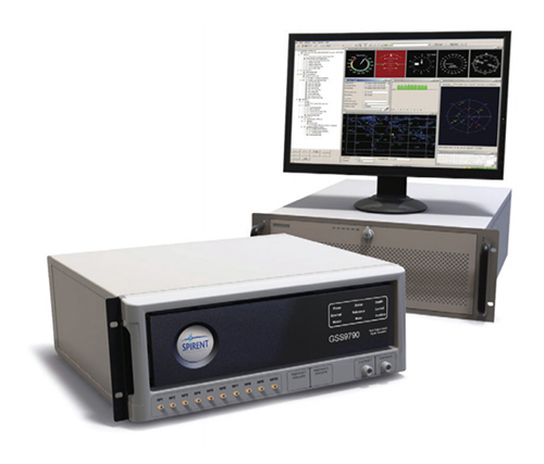
Spirent Federal Systems has been awarded a contract to support anechoic chamber testing for a major U.S. military agency.
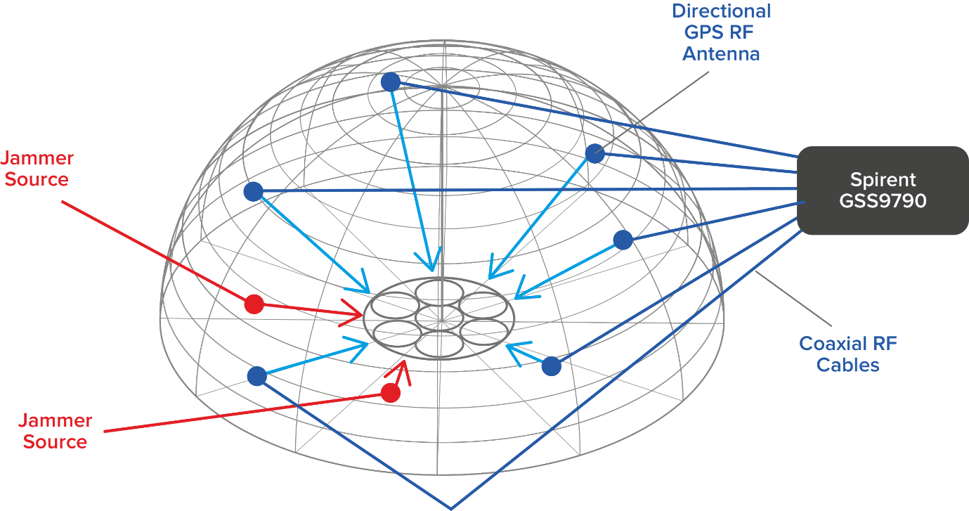
Spirent’s GSS9790 multi-output, multi-GNSS RF constellation wave-front simulator will be used as the signal generator attached to multiple transmission antennas for broadcast into the chambers.
Within this design, the antennas are structurally distributed to represent the correct arrival vectors of the simulated satellite signals on the device under test, creating the most realistic test environment possible. In addition, the GSS9790 supports interference sources located anywhere in the chamber to imitate different threat scenarios.
Image: Spirent
“Interference can threaten GNSS signals in multiple ways,” explained Jeff Martin, VP Sales. “We recognize the need for controlled, repeatable conditions to combat these threats. The GSS9790 delivers all the tools needed to successfully mitigate them.”
The GSS9790 simulator. (Photo: Spirent)
The Spirent GSS9790 supports classified Y-code, SAASM and M-code and can be found in key government labs across the country.
The Spirent GSS9790 enables verification of CRPA systems, spatial testing of single-antenna devices, and real-world-time-synchronized indoor GNSS implementations. The system is a development of the Spirent GSS9000. Combined with Spirent’s SimGEN software, it offers a powerful test platform for anti-jam and interference testing.
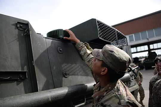
Sixty-two of the first iteration of mounted anti-jam GPS devices were equipped into light armored vehicles in Germany over the past month, with thousands more scheduled to be installed into U.S. European Command vehicles by 2028, said Army leaders in charge of location data on future battlefields.
The Mounted Assured Precision Navigation & Timing System — known as MAPS — was developed to provide trusted positioning, navigation and timing (PNT) to a platform, such as Stryker vehicles, by pairing a GPS receiver with an anti-jam antenna, said Col. Nickolas Kioutas, PNT project manager.
Read more about MAPS, along with other anti-jam systems, here. Also look for our anti-jam feature coming in the December issue of GPS World magazine.
The electronic technology comes amid the Army’s vision for 2028, to best prepare soldiers for possible warfare with near-peer competitors, who have used electronic warfare to disrupt communications vital to Western forces in recent years.
This year, more than 300 Stryker vehicles, all from the 2nd Cavalry Regiment, are expected to be fielded with MAPS technology, said Willie Nelson, the director of the Army’s Assured PNT Cross-Functional Team.
Upgraded first-generation and second-generation technology is also expected to be unveiled in the future.
The Army also plans to equip armored brigades with the technology, and put MAPS in vehicles such as the Bradley Fighting Vehicle, M1 Abrams tank, and the M109 Paladin self-propelled howitzer. After those “priority vehicles,” the Army will evaluate the mounted device in second-tier priority vehicles, Nelson said.
Soldiers from 2-2 Stryker Brigade Combat Team move out in their Stryker during their training rotation at the National Training Center on Fort Irwin, Calif., Sept. 2, 2019. (Photo: Sgt. Ryan Barwick/U.S. Army)
In the past, armored vehicles have used multiple Defense Advanced GPS receivers, known as DAGR devices.
MAPS replaces multiple DAGR devices with one “really good system,” said Kioutas. The new system uses a chip-scale atomic clock for timing, Selective Availability and Anti-Spoof Module, or SAASM, for GPS, and anti-jamming antenna to distribute PNT information.
In addition, future iterations of MAPS will include non-GPS sensors by fusing GPS with alternate navigation and timing technologies to ensure accurate PNT that soldiers can trust while operating in various threat or denied environments, according to a statement.
A single-point GPS also creates multiple practical benefits for soldiers, such as less maintenance and system key-failing, Kioutas said, adding many of his team’s decisions are based on Soldier feedback, because listening to them today helps prepare them for tomorrow.
Simply put, “MAPS continues to work whenever a GPS signal is weakened or compromised,” he said.
“This is the first technology equipping for the Assured Positioning, Navigation and Timing Cross-Functional Team, and one of the first for Army Futures Command,” Kioutas said.
Nelson noted that they’re “working in parallel with both mounted vehicles and dismounted soldier’s PNT gear.”
A soldier checks part of a Mounted Assured Precision Navigation & Timing System — known as MAPS. Sixty-two of the first iteration of mounted anti-jam GPS devices were equipped into light armored vehicles in Germany over the past month, with thousands more scheduled to be installed into U.S. European Command vehicles by 2028. (Photo: John Higgins)
Earlier this year, a requirements document for the dismounted soldier’s PNT was signed. Now, currently in the prototyping phase, the latest iteration of a dismounted GPS receiver can send secure PNT data wired or wirelessly, Kioutas said.
“A lot is happening here, a lot of good success,” Nelson said, adding, the most important thing for his team is to get the best equipment to “warfighters on the front lines and getting their feedback rolled back into the next generation.”
Nelson will host a Warrior’s Corner presentation Oct. 15 focusing on the PNT CFT’s Tactical Space Line of Effort, at the Walter E. Washington Convention center in Washington, D.C.
Acquisition Expands Orolia’s Global Footprint into Canada.
Orolia has acquired Skydel Solutions, a GPS/GNSS signal simulation company based in Montreal, Canada.
Orolia made the announcement at the Association of the U.S. Army’s Global Force Exhibition in Huntsville, Alabama.
Orolia is a resilient positioning, navigation and timing (PNT) solutions company and a partner of U.S., NATO and allied forces. The company provides end-to-end resilient PNT solutions, including scalable, modular and cost-effective technology to support PNT-reliant and critical defense and commercial applications.
Skydel’s capabilities allows Orolia to offer customers more diverse resilient PNT solutions with sophisticated testing and simulation protocols, additional customized signals, and superior vulnerability assessments for military and commercial applications where GNSS failure is not an option.
According to Orolia, as the latest addition to the Orolia portfolio, Skydel brand solutions bring a new paradigm to the GNSS simulator scene by combining innovative algorithms and off-the-shelf hardware to help protect the world’s most critical GNSS-reliant systems operating through GPS, Galileo and other GNSS.
Skydel technology also supports secure communications signals such as SAASM, M-code, PRS and other alternative signals with approved partners to provide real-world PNT vulnerability testing for critical infrastructure applications worldwide.
“The need for continuous, reliable GNSS signals is growing exponentially worldwide, particularly for military and commercial systems that depend on accurate PNT data,” said Orolia CEO Jean-Yves Courtois. “The threats to these systems are growing too, whether it’s through signal jamming, spoofing or meaconing. With Skydel’s unique industry expertise, Orolia now offers even more rigorous, broad spectrum testing and simulation solutions to ensure continuous signals, even in GNSS-denied environments.”
By combining graphics processing unit (GPU) accelerated computing and software-defined radios (SDR), Skydel-powered simulation solutions generate signals in real time, with uncompromising performance for demanding use cases. They are available as complete turnkey systems suitable for all GNSS simulation needs, including everything from compact test benches to complete CRPA test systems.
“Since our inception in 2014, Skydel has enjoyed exponential growth,” said Stéphane Hamel, CEO of Skydel. “This strategic move with Orolia will allow us to keep our focus on disruptive innovation and accelerate our global reach.”
Above: A montage of screenshots showing the various updates, from a February 2019 story about Skydel updating its SDX GNSS simulator to version 19.1 with Galileo Alt-BOC and more. (Image: Skydel)
Microsemi Corporation’s new SyncServer S650 SAASM server incorporates a Selective Availability Anti-Spoofing Module (SAASM).
The SAASM capability provides a highly secure, accurate and flexible time and frequency platform for synchronizing mission-critical electronics systems and instrumentation applications in the defense market, such as satellite communications and defense operational infrastructure, the company said.
Military Grade. The new SyncServer S650 SAASM, designed for use by the U.S. Department of Defense (DOD) and other government agencies as well as their approved suppliers, received the GPS Directorate Security Approval to incorporate a military-grade, GPS SAASM receiver module.
Microsemi SyncServer S650 SAASM Time and Frequency Server.
This enables U.S. armed forces to confidently deploy features of Microsemi’s popular commercial SyncServer S650 in a military-grade configuration. In addition, the integrated SAASM module adheres to industry standards allowing for a migration path to GPS Military Code (M-code) support.
“Our key military and DOD-related customers require flexible, secure and extremely reliable time and frequency technology for their most critical applications, which they have come to rely upon from Microsemi. Enabling support for SAASM provides the extra security and reliability necessary for this market,” said Randy Brudzinski, vice president and business unit manager of the Frequency and Timing Division at Microsemi. “The addition of the SyncServer S650 SAASM to our product line further demonstrates Microsemi’s commitment to providing the highest quality time and frequency technology in support of vital government programs.”
The SyncServer S650 SAASM is a highly versatile time and frequency system with the company’s FlexPort technology for multiport, user-definable output signal configurations for time codes, pulses and a variety of signal types essential for system synchronization.
This makes the SyncServer S650 SAASM ideal for DoD electronics system engineers synchronizing mission-critical, system-level instruments. This is coupled with Microsemi’s NTP Reflector technology for robust security, accuracy and reliability of network-based time services such as Network Time Protocol (NTP) and Precision Time Protocol (PTP).
Resilience to Threats. According to a 2017 GNSS Market Report, global navigation satellite system (GNSS) jamming and spoofing are specifically identified as increasing and notable cybersecurity threats to critical infrastructure.
Furthermore, resilience to these threats has become mandatory by critical infrastructure policy makers and GNSS receiver manufacturers. Without the use of SAASM technology in the presence of these threats, deliberate or unintentional, the most mission-critical systems operated by the DOD may be subject to the side effects of degraded time and frequency performance.
Microsemi’s new SyncServer S650 SAASM is designed to generate precise time and frequency signals to synchronize high bandwidth mission-critical communications systems and critical infrastructure requiring the highest levels of security support.
In addition to offering superior low phase noise performance, the device is compliant with the Joint Chiefs of Staff SAASM GPS mandate and developed for authorized military users only.
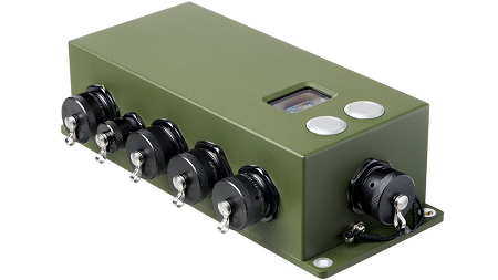
The German Ministry of Defense selected Rockwell Collins’ NavHub navigation system to provide GNSS availability to a variety of its military vehicles.
The NavHub system serves as a next-generation GNSS- and Military-code (M-code)-enabled solution for the German Armed Forces.
Customizable for ground and maritime platforms, NavHub provides a variety of vehicle interfaces, meets the standards required by military vehicle operators, and allows users to receive data from multiple secure and open-service GNSS constellations to simultaneously confirm the navigational solution.
Access to multi-constellation GNSS and GPS M-Code will provide a significantly enhanced navigational solution over the current GPS-only solution.
Work under the contract will be performed in Rockwell Collins’ facilities in in Europe.
About the NavHub GNSS navigation system
NavHub (Image:: Rockwell Collins)
Based on Rockwell Collins Selective Availability/Anti-Spoofing Module (SAASM) GPS receivers, NavHub is strategically designed to meetfast-moving and demanding combat environments.
Through the use of dual-installed GNSS receivers, NavHub provides an assured navigational solution, interfaces and GNSS upgrade path to support modern operations platforms.
SAASM security (expansion to M-code), expansion to multi constellation GNSS
Extended platform interfaces, including Ethernet, USB and CAN
Extended performance in a jammed environment (i.e., 41 dB while tracking and 24 dB during initial acquisition)
“NavHub meets the critical mission need for accurate navigation support for fast-moving platforms and challenging environments,” said Claude Alber, vice president and managing director, Europe, Middle East and Africa for Rockwell Collins. “Our military GNSS receivers will provide significantly enhanced navigational capabilities to military vehicles and will mitigate terrain, forest and urban degradation as it will raise the number of satellites used from 28 to well over 100.”
GPS Source has received Global Positioning Systems Directorate security approval for its family of Selective Availability Anti-spoofing Module (SAASM)-based Host Application Equipment (HAE).
GPS Source announced security approval for the Enhanced D3 (ED3) and Enhanced FLO-G (E-FLO-G) with integrated SAASM receivers. The ED3 and E-FLO-G are upgradeable versions of the popular DAGR Distributed Device (D3) and are capable of distributing SAASM today, and M-code protected GPS data when implemented.
Enhanced DAGR Distributed Device by GPS Source.
GPS Sources’ family of PNT distribution products represents the most advanced, cost effective and comprehensive solution available on the market to support Department of Defense’s GPS modernization efforts. Moreover, the ED3 and the E-FLO-G bridge the gap between legacy systems deployed today and the C4ISR/EW architectures of the future.
“We understand the importance of designing products that comply with all GPS Directorate security requirements,” said Robert Horton, CEO of GPS Source. “This security approval makes it possible for the ED3 and E-FLO-G to be deployed by military forces without reservation. GPS Source is proud to be a key supplier of such important enablers to the warfighter and to be the provider of innovative military GPS solutions to our defense customers.”
“Integrating legacy equipment utilizing SAASM receivers with future equipment relying on M-code receivers is challenging,” Horton continued. “But through Independent Research and Development, GPS Source ensured the ED3 and E-FLO-G integrate appropriately with SAASM today and M-code in the future. These accomplishments exemplify the technology in development by GPS Source to sustain the equipment that warfighters will employ today and tomorrow.”
GPS Source has begun taking orders for the ED3 and GLI-FLO-G. Production will start mid-year. Questions about this technology can be directed to Kurt Williams, director of Sales and Marketing.
Rockwell Collins is bringing its NavFire Precision Positioning Service (PPS) GPS to Leonardo-Finmeccanica’s Vulcano family for naval and artillery applications.
NavStrike military GPS offers high performance GPS for tightly coupled GPS/INS integrations.
Derived from the field-proven 12-channel NavFire Precise Positioning Service GPS receiver, Rockwell Collins’ NavStrike military GPS offers high performance GPS for tightly coupled GPS/inertial navigation system (GPS/INS) integrations.
“We have customized the NavFire receivers for the particular caliber of the ammunition, and provided full support to the customer during and after the firing trials,” said Claude Alber, vice president and managing director, Europe, Middle East and Africa for Rockwell Collins. “In the end, our product perfectly matched the demanding performance requirements of our customer.”
The NavFire GPS includes the Selective Availability Anti-Spoofing Module (SAASM) to allow decryption of precision GPS observations through over-the-air rekeying. The positioning information is used by the guidance system of the projectile.
Nearly 30 years ago, Rockwell Collins assisted the U.S. Air Force in developing GPS technology and that legacy continued when the company created the world’s first all-digital miniature GPS receiver under contract with DARPA. Over the years, Rockwell Collins has produced more than 50 GPS products and delivered more than 1 million GPS receivers for commercial avionics and government applications. This recent GPS contract continues this legacy to create leading edge military navigation solutions.
Sponsored by: Loctronix Corporation Broadcast Date: Thursday, May 22, 2014
Host: Dr. Michael B. Mathews, CEO and Founder, Loctronix Corporation
Speakers: Franck Boynton, Vice President and CTO, NavtechGPS; Peter F. MacDoran, Chief Scientist, Loctronix Corporation; Michael O. Davies, Senior Engineer, Loctronix Corporation Summary: The need for robust, highly-reliable, navigation information in GNSS-denied environments is fast becoming a critical issue for unmanned aerial vehicles (UAV) / unmanned aircraft systems (UAS) in both commercial and military applications. Total reliance on GNSS can lead to disastrous consequences when signals are interfered with or obstructed. Low-cost, non-SAASM, GPS sensors are particularly vulnerable to jamming and interference. Attendees will learn how robust, cost-effective Hybrid GNSS Technologies (HGT) offer unique capabilities for UAV navigation in environments where traditional GPS receivers may fail. Combining signals of opportunity (SoOps), inertial sensing, and multi-frequency GNSS using Spectral Compression Positioning, assures continuous navigation by detecting typical GNSS interference and mitigating their effects through alternative navigation means. Download a PDF of the webinar slides
Mayflower Communications Company Inc. will develop a small security-certifiable GPS module for the United States Air Force’s Modernized GPS User Equipment (MGUE) Program.
The Mayflower NavAssure 125a GPS receiver.
Mayflower was awarded a Phase III SGUE (Small GPS User Equipment) contract with the U.S. Air Force Research Laboratory sponsored by the Space and Missile Systems Center/GPS Directorate (SMC/GPSD).
Under the contract, the company will develop a small SWaP (Size, Weight, and Power) security certifiable Common GPS Module (CGM).
Mayflowers’ small SWaP GPS receiver technology will allow the Department of Defense (DoD) and its agencies to benefit from increased competition, enhanced capability and reduction in overall program costs to DoD program managers and prime contractors in upgrading their navigation systems to the modernized M-code receiver.
Mayflower’s SGUE program is aimed at the development of advanced GPS receiver technology to support future military GPS requirements. The goal of the program is to develop a NAVWAR (Navigation Warfare) compatible CGM form factor that will support SWaP-constrained military users.
The SGUE CGM development effort will expand Mayflower’s military GPS receiver product line to include modernized NavAssure-M product offerings so that current customers will have a form-fit-function upgrade path from SAASM to MGUE.
“Mayflower is a leader in small SWaP and miniaturized military GPS receiver and anti-jam products,” said Triveni Upadhyay, Mayflower founder and CEO. “I am confident in the quality and innovation expertise of our GPS engineering team to successfully develop the SGUE CGM. The development of small SWaP MGUE form factors, enabled by SGUE CGM, will have a significant impact in the M-Code market, providing secure modernized GPS signals to the warfighters and lowering total ownership costs on many military programs.”
“The Air Force is very pleased to see innovative GPS technology developed under its SBIR Program to find commercialization opportunity in the MGUE market. Mayflower has performed well and we are confident of the SGUE program success,” said Dana Howell, Air Force Research Laboratory (AFRL) program manager.
“The AFRL/GPSD objective in the SGUE Program is to advance MGUE technology and make it affordable to the warfighter,” said Eddy Emile, chief of the Advanced Technology and International Branch, GPS Directorate. ”
The SGUE Program fits the need and will lower the cost to the user by increased competition enabled by the SGUE Program.”
According to Mayflower, the NavAssure-M MGUE receiver form factors, focused toward small SWaP GPS receiver applications, will be backward compatible to SAASM, therefore, lowering the platform integration cost and total life-cycle cost.
Garmin’s eTrex Touch 25, 35 and 35t outdoor handhelds have an updated user interface and 2.6-inch capacitive touchscreen display. The eTrex Touch series also features activity profiles for navigation for multiple activities and an enhanced track manager to start and stop recording.
The eTrex Touch series has a high-sensitivity, WAAS-enabled GPS receiver with GLONASS support and HotFix satellite prediction to locate users’ position quickly and precisely, even in heavy cover and deep canyons. All units have a three-axis tilt-compensated electronic compass, which gives directional information even when standing still. The eTrex 35 and 35t also have a barometric altimeter to get more accurate altitude, elevation and climb information, as well as indications of weather changes.
Garmin, www.garmin.com
Fleet Management
Supervisor App for Fleets
The Supervisor app for the FieldMaster suite of mobile applications allows managers to leave the office and still have visibility into their fleet and mobile workers from their smartphone or tablet, as well as manage day-to-day operations remotely.
FieldMaster Supervisor is available with Trimble Fleet Management and Work Management. Features include viewing the team’s locations on a map; seeing their job progress, including tasks at risk; finding the nearest worker to another team member or customer; turn-by-turn navigation; inspecting job performance and documenting status in the field; and receiving vehicle and driver performance alerts in real-time.
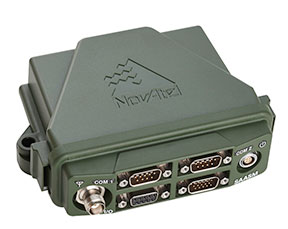
NovAtel’s SPAN GNSS/INS technology is now available on the company’s OEM625S dual-frequency SAASM GPS plus civil RTK receiver. SPAN offers system developers with SAASM requirements the benefit of continuously available 3D positioning, velocity and attitude (roll, pitch, yaw) for their defense applications. Authorized defense customers need access to the Precise Positioning Service (PPS) for DOD applications. When keyed, the existing OEM625S board-level receiver provides an RTK PPS solution by taking the raw measurements from an L-3 XFACTOR SAASM and applying them to NovAtel’s RTK algorithm. SPAN technology couples NovAtel’s precision GNSS receivers with robust IMUs to provide a more reliable, stable solution, even during short periods of time when satellite signals are blocked or unavailable.
The Averna RP-6100 series is an RF tool offering high-performance record-and-playback and real-time simulation in one platform for RF application validation.
The RP-6100 can capture all GNSS bands, as well as HD Radio, Wi-Fi, LTE, radar, and cognitive radio — plus impairments — to advance RF projects and harden product designs. It features up to four channels, 160 MHz of recording bandwidth, tight channel synchronization, an extended frequency range of 10 MHz to 6 GHz and 14-bit resolution. The RP-6100 can be equipped with Skydel Solutions’ software-defined, real-time GNSS simulator, which delivers easy setups, integrated maps, dynamic scenario creation, high precision and tight parameter controls to enable highly repeatable simulations of current and future GNSS conditions, as well as corner cases.
The AirPrime WP Series of smart wireless modules is designed for the development of connected products. The WP Series provides an integrated device-to-cloud architecture enabling developers to build a Linux-based product using a single module that sends user and product data to the cloud. The AirPrime WP series offers an application processor, GNSS receiver, and cellular modem with an optional ultra-low power mode that reduces power consumption by 200 times, opening up new use-case possibilities for cellular connectivity.
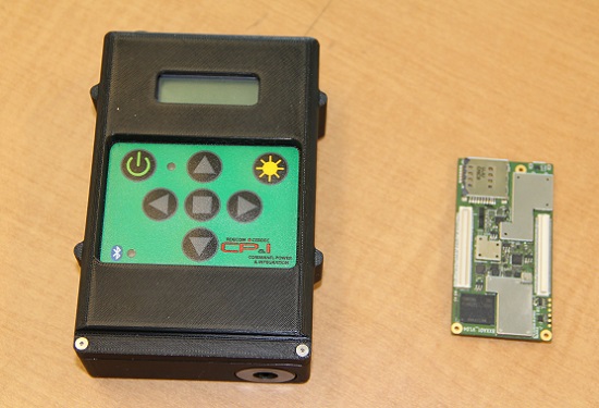
The current WINS form factor (left) sits beside a prototype for the future incarnation.
The Evolution of the Warfighter Integrated Navigation System
A new device is being developed to enable foot soldiers to find their exact location in GPS-denied situations. If satellite signals are blocked by heavy jungle canopy, or because of enemy interference, soldiers — and Headquarters — will still know where they are with the Warfighter Integrated Navigation System (WINS).
WINS will be a compact, wearable navigation device capable of operating either as a standalone system or networked to distribute position location information to other soldier platforms. WINS will extend positioning capability for soldiers in environments where GPS is not available, reducing the effect of GPS interference and enabling integrity monitoring for trusted position reporting.
The technology behind WINS is being developed at the U.S. Army’s Communications Electronics Research Development and Engineering Center (CERDEC) labs. “WINS will be not just one technology; it’s a soldier-worn multi-sensor source incorporating information from GPS, inertials, vision-aided navigation, RF ranging, etc.,” explained John DelColliano, chief for CERDEC’s PNT Branch, which falls under CERDEC’s Command, Power and Integration Directorate (CP&I).
“All these will tie in to making a more robust navigation system, so if you’re in a situation where GPS fails, you can have other things to back you up.” For instance, inertial sensors will calculate an offset from the last-known GPS location using footsteps taken, speed, acceleration and time.
“The bottom line is that the soldier, without having to do any extra work on his own, will have a navigation system on his person that will provide him with a solution that he can count on when he needs it,” DelColliano said.
WINS is expected to help eliminate dependence on vulnerable commercial receivers. It will improve positioning in GPS-degraded environments, enduring some jamming and providing positioning indoors and in urban areas. It will enable soldier-based cooperative engagements and provide trusted dismounted soldier position through integration with Selective Availability Anti-Spoofing Module (SAASM) GPS receivers and redundant navigation sensors.
“CP&I’s PNT branch has worked on these individual technologies for many years, but we’ve always had the vision of an integrated solution,” DelColliano said. “That’s where we are today. It makes the most sense for what the soldier is going to need in the battlefield.” With a WINS-equipped solder, DelColliano said, “We’ll be able to know where he is and at what time, and we’ll be able to track if something happened to him. This capability will also enable our forces to be more mobile and maneuverable. It allows the commander and HQ to see where each squad is.”
As part of a technology demonstration program at Fort Dix, N.J., WINS is being developed under an incremental build process as researchers consider what functionality should be incorporated. The engineering specifications for WINS are expected to be transferred to Program Executive Office, Intelligence and Electronic Warfare & Sensors by 2017, and from there eventually be made available to soldiers.
Future WINS capabilities
The final version of the WINS will have the following capabilities:
Military GPS for a protected signal and anti-jam capability on the soldier.
Inertial measurement unit for soldiers to track their location.
RF ranging using a radio or radio-like device to communicate between soldier-worn nodes and determine the range between soldiers, computing positions through triangulation relative to GPS.
Vision-aided navigation using the same kind of camera as in a cell phone, which is ideal for SWaP-C (size, weight and power compliance), to help navigate by tracking the soldier’s motion through an environment.